|
Central Highlands Regional Council
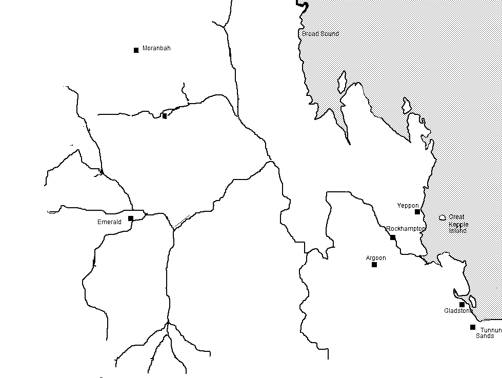
Central Highlands Region is a local government area in Queensland, Australia. History '' Wadja'' (also known as ''Wadjigu'', ''Wadya'', ''Wadjainngo'', ''Mandalgu'', and ''Wadjigun)'' is an Australian Aboriginal language in Central Queensland. The language region includes the local government areas of the Aboriginal Shire of Woorabinda and Central Highlands Region, including the Blackdown Tableland, the Comet River, and the Expedition Range, and the towns of Woorabinda, Springsure and Rolleston. '' Yambina'' (also known as ''Jambina'' and ''Jambeena'') is an Australian Aboriginal language of Central Queensland. Its traditional language region is the local government area of Central Highlands Region, including Peak Downs, Logan Creek, south to Avon Downs, east to Denham Range and Logan Downs, west to Elgin Downs and at Solferino. '' Yetimarala'' (also known as ''Jetimarala'', ''Yetimaralla'', and ''Bayali'') is an Australian Aboriginal language of Central Queensland. Its ... [...More Info...] [...Related Items...] OR: [Wikipedia] [Google] [Baidu] |
Queensland
) , nickname = Sunshine State , image_map = Queensland in Australia.svg , map_caption = Location of Queensland in Australia , subdivision_type = Country , subdivision_name = Australia , established_title = Before federation , established_date = Colony of Queensland , established_title2 = Separation from New South Wales , established_date2 = 6 June 1859 , established_title3 = Federation , established_date3 = 1 January 1901 , named_for = Queen Victoria , demonym = , capital = Brisbane , largest_city = capital , coordinates = , admin_center_type = Administration , admin_center = 77 local government areas , leader_title1 = Monarch , leader_name1 = Charles III , leader_title2 = Governor , leader_name2 = Jeannette Young , leader_title3 = Premier , leader_name3 = Annastacia Palaszczuk ( ALP) , legislature = Parliament of Queensland , judiciary = Supreme Court of Queensland , national_representation = Parliament of Australia , national_representation_type ... [...More Info...] [...Related Items...] OR: [Wikipedia] [Google] [Baidu] |
Aboriginal Shire Of Woorabinda
The Aboriginal Shire of Woorabinda is a local government area in Central Queensland, Australia. Geography Most local government areas are a single contiguous area (possibly including islands). However, Aboriginal Shires are often defined as a number of disjoint areas each containing an Indigenous community. In the case of the Aboriginal Shire of Woorabinda, the distinct regions are: * part of the locality of Balcomba (remainder in Central Highlands Region) * part of the locality of Bauhinia (remainder in Central Highlands Region) * part of the locality of Duaringa (remainder in Central Highlands Region) * part of the locality of Wallaroo (remainder in Central Highlands Region) * the town and locality of Woorabinda (entirely in the Aboriginal Shire of Woorabinda) History '' Wadja'' (also known as ''Wadjigu'', ''Wadya'', ''Wadjainngo'', ''Mandalgu'', and ''Wadjigun)'' is an Australian Aboriginal language in Central Queensland. The language region includes the local gove ... [...More Info...] [...Related Items...] OR: [Wikipedia] [Google] [Baidu] |
Fitzroy River (Queensland)
The Fitzroy River (Darumbal: ''Toonooba'') is a river located in Central Queensland, Australia. Its catchment covers an area of , making it the largest river catchment flowing to the eastern coast of Australia. It is also the largest river basin that discharges onto the Great Barrier Reef. Course and features Formed by the confluence of the Mackenzie and Dawson rivers that drain the Expedition Range and the Carnarvon Range respectively, the Fitzroy River rises near Duaringa and flows initially north by east, then northward near the Goodedulla National Park. The river then flows in an easterly direction near the Lake Learmouth State Forest and parallel with the Bruce Highway through the settlement of , before turning south to where the river is crossed by the Bruce Highway. After flowing through Rockhampton, the river flows south by east past the Berserker Range past Humbug Point to the south of the Flat Top Range and eventually discharging into Keppel Bay in the Coral Sea nea ... [...More Info...] [...Related Items...] OR: [Wikipedia] [Google] [Baidu] |
Boomer Range
Baby boomers, often shortened to boomers, are the Western demographic cohort following the Silent Generation and preceding Generation X. The generation is often defined as people born from 1946 to 1964, during the mid-20th century baby boom. The dates, the demographic context, and the cultural identifiers may vary by country. The baby boom has been described variously as a "shockwave" and as "the pig in the python". Most baby boomers are children of either the Greatest Generation or the Silent Generation, and are often parents of late Gen Xers and Millennials. Late baby boomers can also be the parents of older members of Generation Z. In the West, boomers' childhoods in the 1950s and 1960s had significant reforms in education, both as part of the ideological confrontation that was the Cold War, and as a continuation of the interwar period. In the 1960s and 1970s, as this relatively large number of young people entered their teens and young adulthood—the oldest turned 18 in 196 ... [...More Info...] [...Related Items...] OR: [Wikipedia] [Google] [Baidu] |
Yetimarala Language
Biri, also known as Biria, Birri Gubba, Birigaba, Wiri, Perembba and other variants, is an Australian Aboriginal language of the Mackay area of Queensland spoken by the Birri Gubba people. There are at least eight languages regarded as dialects of Biri, and two which are related but whose status is not yet fully determined (see the table to the right). All are covered in this article. A grammar of Biri proper was written before the language became nearly extinct. some of the dialects have been undergoing a revival for some years. Dialects The following languages are regarded as confirmed dialects of Biri by the AUSTLANG database maintained by AIATSIS. Only one alternative name is given, for brevity; most have many more. All of these dialects appear to be extinct; AUSTLANG shows no speakers for any of them since 1975. *E38: Garaynbal (Garingbal) *E40: Gangulu (Kaangooloo) *E48: Baradha (Thar-ar-ra-burra) *E51: Yambina (Jampal) *E52: Yangga (Jangga) *E54: Yuwi (Juipera) ... [...More Info...] [...Related Items...] OR: [Wikipedia] [Google] [Baidu] |
Denham Range
Denham may refer to: People *Denham (surname) *Denham Price (1940–2013), South African cricketer Places ;In the United Kingdom: * Denham, Buckinghamshire **Denham Aerodrome ** Denham Country Park **Denham Film Studios ** Denham railway station ** Denham Roundabout * Denham, Mid Suffolk, Suffolk * Denham, St Edmundsbury, Suffolk * Denham Street, Suffolk * Corton Denham, Somerset * Great Denham, Bedfordshire ;Elsewhere: * Denham, Western Australia, within Shark Bay * Denham Town, Kingston, Jamaica * Denham, Indiana, United States * Denham, Minnesota, United States * Den Ham, Twenterand, Netherlands Other * Denham baronets, a baronetcy created in 1693 See also * Dinham (other) * Denholm Denholm is a small village located between Jedburgh and Hawick in the Scottish Borders region of Scotland, UK. The estimated population of Denholm is 600. There is a village green in the centre. It lies in the valley of the River Teviot. Denho ... * Dunham (disambiguatio ... [...More Info...] [...Related Items...] OR: [Wikipedia] [Google] [Baidu] |
Shire Of Peak Downs
Shire is a traditional term for an administrative division of land in Great Britain and some other English-speaking countries such as Australia and New Zealand. It is generally synonymous with county. It was first used in Wessex from the beginning of Anglo-Saxon settlement, and spread to most of the rest of England in the tenth century. In some rural parts of Australia, a shire is a local government area; however, in Australia it is not synonymous with a "county", which is a lands administrative division. Etymology The word ''shire'' derives from the Old English , from the Proto-Germanic ( goh, sćira), denoting an 'official charge' a 'district under a governor', and a 'care'. In the UK, ''shire'' became synonymous with ''county'', an administrative term introduced to England through the Norman Conquest in the later part of the eleventh century. In contemporary British usage, the word ''counties'' also refers to shires, mainly in places such as Shire Hall. In regions with ... [...More Info...] [...Related Items...] OR: [Wikipedia] [Google] [Baidu] |
Yambina Language
Biri, also known as Biria, Birri Gubba, Birigaba, Wiri, Perembba and other variants, is an Australian Aboriginal language of the Mackay area of Queensland spoken by the Birri Gubba people. There are at least eight languages regarded as dialects of Biri, and two which are related but whose status is not yet fully determined (see the table to the right). All are covered in this article. A grammar of Biri proper was written before the language became nearly extinct. some of the dialects have been undergoing a revival for some years. Dialects The following languages are regarded as confirmed dialects of Biri by the AUSTLANG database maintained by AIATSIS. Only one alternative name is given, for brevity; most have many more. All of these dialects appear to be extinct; AUSTLANG shows no speakers for any of them since 1975. *E38: Garaynbal (Garingbal) *E40: Gangulu (Kaangooloo) *E48: Baradha (Thar-ar-ra-burra) *E51: Yambina (Jampal) *E52: Yangga (Jangga) *E54: Yuwi (Juipera) * ... [...More Info...] [...Related Items...] OR: [Wikipedia] [Google] [Baidu] |
Rolleston, Queensland
Rolleston is a rural town and locality in the Central Highlands Region, Queensland, Australia. In the , the locality of Rolleston had a population of 309 people. Geography Rolleston is located on the Comet River, west of Gladstone, 263 kilometres (163 mi) north of Roma and northwest of Brisbane. Springsure, the nearest town, lies to the north-west. Rolleston is at the junction of the Carnarvon, Gregory and Dawson highways. There is a large coal mine west called the Rolleston coal mine. History Rolleston was built on Kanolu land. '' Wadja'' (also known as ''Wadjigu'', ''Wadia'', ''Wadjainngo'', ''Mandalgu'', and ''Wadjigun)'' is an Australian Aboriginal language in Central Queensland. The language region includes the local government areas of the Aboriginal Shire of Woorabinda and Central Highlands Region, including the Blackdown Tablelands. the Comet River, and the Expedition Range, and the towns of Woorabinda, Springsure and Rolleston. The town is named afte ... [...More Info...] [...Related Items...] OR: [Wikipedia] [Google] [Baidu] |
Springsure
Springsure is a town and a Suburbs and localities (Australia), locality in the Central Highlands Region, Queensland, Australia. It is south of Emerald, Queensland, Emerald on the Gregory Highway. It is the southern terminus of the Gregory Highway and the northern terminus of the Dawson Highway. It is northwest of Brisbane. At the , Springsure had a population of 950 people. Geography Today, Springsure is a pastoral settlement serving cattle farms, and sunflower, sorghum, wheat and chickpea plantations. Springsure is the hub for several coal mines such as the Minerva Mine and the Rolleston Mine. Significant exploration is ongoing in the district. It is also a staging point for expeditions to Carnarvon National Park. History ''Gangulu language, Gangalu (Gangulu, Kangulu, Kanolu, Kaangooloo, Khangulu)'' is an Australian Aboriginal language spoken on Gangula country. The Gangula language region includes the towns of Clermont, Queensland, Clermont and Springsure extending south t ... [...More Info...] [...Related Items...] OR: [Wikipedia] [Google] [Baidu] |
Woorabinda, Queensland
Woorabinda is a rural town and locality in the Aboriginal Shire of Woorabinda, Queensland, Australia. In the , Woorabinda had a population of 962 people. It is an Aboriginal community. Geography Woorabinda is in Central Queensland, inland about two hours' drive west of Rockhampton. The seasonal Mimosa Creek is nearby and is a source of local water. During rainy season, the town can be isolated due to road flooding. Access is via the Fitzroy Developmental Road, which is sealed north towards Duaringa and where it meets the Capricorn Highway to Rockhampton. To the south, it is gravel road to Bauhinia, where it meets the Dawson Highway and access to Gladstone. East is the sealed Baralaba-Woorabinda Road, seasonally cut off by flooding. West has a number of cattle properties until the base of the Blackdown Tablelands, serviced by gravel roads. There is also a sealed airstrip along the north road into town, used by chartered flights and aeromedical retrieval services. No commercia ... [...More Info...] [...Related Items...] OR: [Wikipedia] [Google] [Baidu] |


