|
Central African Republic–Republic Of The Congo Border
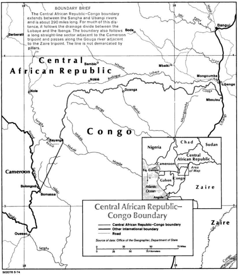
The Central African Republic–Republic of the Congo border is 487 km (303 mi) in length and runs from the tripoint with Cameroon in the west to the tripoint with the Democratic Republic of the Congo in the east. Description The border starts in the west at the tripoint with Cameroon in the Sangha River, and then proceeds via a straight line overland towards the northwest. It then proceeds via a series of irregular lines to the north, generally following the Sangha- Ubangi drainage divide, before turning a broad arc to the east, and then continuing in that direction broadly following the Ibenga- Bodingué drainage divide. It then follows the Lobaye-Gouga drainage divide up to the Democratic Republic of the Congo tripoint at the confluence of the Gouga and Ubangi. History The border first emerged during the Scramble for Africa, a period of intense competition between European powers in the later 19th century for territory and influence in Africa. The process culminated i ... [...More Info...] [...Related Items...] OR: [Wikipedia] [Google] [Baidu] |
Congo-Brazzaville
The Republic of the Congo (french: République du Congo, ln, Republíki ya Kongó), also known as Congo-Brazzaville, the Congo Republic or simply either Congo or the Congo, is a country located in the western coast of Central Africa to the west of the Congo river. It is bordered to the west by Gabon, to its northwest by Cameroon and its northeast by the Central African Republic, to the southeast by the Democratic Republic of the Congo, to its south by the Angolan exclave of Cabinda and to its southwest by the Atlantic Ocean. The region was dominated by Bantu-speaking tribes at least 3,000 years ago, who built trade links leading into the Congo River basin. Congo was formerly part of the French colony of Equatorial Africa. The Republic of the Congo was established on 28 November 1958 and gained independence from France in 1960. It was a Marxist–Leninist state from 1969 to 1992, under the name People's Republic of the Congo. The country has had multi-party elections since 1 ... [...More Info...] [...Related Items...] OR: [Wikipedia] [Google] [Baidu] |
Borders Of The Central African Republic
A border is a geographical boundary. Border, borders, The Border or The Borders may also refer to: Arts, entertainment and media Film and television * ''Border'' (1997 film), an Indian Hindi-language war film * ''Border'' (2018 Swedish film), a fantasy film * ''Border'' (2018 Bhojpuri film), a war film * ''The Border'' (1982 film), an American drama * ''The Border'' (1996 film), an Italian war drama * ''The Border'' (2007 film), a Finnish-Russian war drama * ''The Border'' (2009 film), a Slovak documentary * ''The Border'' (TV series) a 2008–10 Canadian drama series Literature * "The Border", a 2004 short story by Richard Harland * "The Border", a 2019 novel by Don Winslow Music * "Border" (song), by Years & Years, 2015 * "Borders" (Feeder song), 2012 * "Borders" (M.I.A. song), 2015 * "Borders" (The Sunshine Underground song), 2007 * ''The Border'', soundtrack to the 1982 film, by Ry Cooder * "The Border" (America song), 1983 * "The Border" (Mr. Mister song), ... [...More Info...] [...Related Items...] OR: [Wikipedia] [Google] [Baidu] |
Central African Republic–Republic Of The Congo Border
The Central African Republic–Republic of the Congo border is 487 km (303 mi) in length and runs from the tripoint with Cameroon in the west to the tripoint with the Democratic Republic of the Congo in the east. Description The border starts in the west at the tripoint with Cameroon in the Sangha River, and then proceeds via a straight line overland towards the northwest. It then proceeds via a series of irregular lines to the north, generally following the Sangha- Ubangi drainage divide, before turning a broad arc to the east, and then continuing in that direction broadly following the Ibenga- Bodingué drainage divide. It then follows the Lobaye-Gouga drainage divide up to the Democratic Republic of the Congo tripoint at the confluence of the Gouga and Ubangi. History The border first emerged during the Scramble for Africa, a period of intense competition between European powers in the later 19th century for territory and influence in Africa. The process culminated i ... [...More Info...] [...Related Items...] OR: [Wikipedia] [Google] [Baidu] |
Central African Republic-Republic Of The Congo Relations
Central is an adjective usually referring to being in the center of some place or (mathematical) object. Central may also refer to: Directions and generalised locations * Central Africa, a region in the centre of Africa continent, also known as Middle Africa * Central America, a region in the centre of America continent * Central Asia, a region in the centre of Eurasian continent * Central Australia, a region of the Australian continent * Central Belt, an area in the centre of Scotland * Central Europe, a region of the European continent * Central London, the centre of London * Central Region (other) * Central United States, a region of the United States of America Specific locations Countries * Central African Republic, a country in Africa States and provinces * Blue Nile (state) or Central, a state in Sudan * Central Department, Paraguay * Central Province (Kenya) * Central Province (Papua New Guinea) * Central Province (Solomon Islands) * Central Province, Sri ... [...More Info...] [...Related Items...] OR: [Wikipedia] [Google] [Baidu] |
French Community
The French Community (1958–1960; french: Communauté française) was the constitutional organization set up in 1958 between France and its remaining African colonies, then in the process of decolonization. It replaced the French Union, which had reorganized the colonial empire in 1946. While the Community remained formally in existence until 1995, when the French Parliament officially abolished it, it had effectively ceased to exist and function by the end of 1960, by which time all the African members had declared their independence and left it. The Community had a short lifespan because, while the African members did not refuse it, they refrained from giving it real life. Under the appearance of equality, the constitution of the Community restricted the sovereignty of the twelve new African states, and reaffirmed the preeminence of France, by placing in the ''domaine commun'' (exercised in common) critical functions such as foreign affairs, defence, the currency, economic po ... [...More Info...] [...Related Items...] OR: [Wikipedia] [Google] [Baidu] |
Second World War
World War II or the Second World War, often abbreviated as WWII or WW2, was a world war that lasted from 1939 to 1945. It involved the vast majority of the world's countries—including all of the great powers—forming two opposing military alliances: the Allies and the Axis powers. World War II was a total war that directly involved more than 100 million personnel from more than 30 countries. The major participants in the war threw their entire economic, industrial, and scientific capabilities behind the war effort, blurring the distinction between civilian and military resources. Aircraft played a major role in the conflict, enabling the strategic bombing of population centres and deploying the only two nuclear weapons ever used in war. World War II was by far the deadliest conflict in human history; it resulted in 70 to 85 million fatalities, mostly among civilians. Tens of millions died due to genocides (including the Holocaust), starvation, ma ... [...More Info...] [...Related Items...] OR: [Wikipedia] [Google] [Baidu] |
Lobaye
Lobaye is one of the 16 prefectures of the Central African Republic. Its capital is Mbaïki. Emperor Duy Tân of Vietnam died here on December 26, 1945 in a plane crash. David Dacko, the first and third president of the Central African Republic from 1960-1965 and 1979–1981, was from Lobaye. Location The prefecture is located in the southern part of the country, bordering the Republic of the Congo and the Democratic Republic of the Congo. It shares borders with the prefectures of Mambéré-Kadéï to the northwest, Sangha-Mbaéré to the west, and Ombella-M'Poko to the northeast. It is named for the Lobaye River. Economy Besides Mbaïki, other important cities include Boda, in the north, and Mongoumba, by the Ubangi River. Most of the inhabitants are coffea ''Coffea'' is a genus of flowering plants in the Family (biology), family Rubiaceae. ''Coffea'' species are shrubs or small trees native to tropical and southern Africa and tropical Asia. The seeds of some species, cal ... [...More Info...] [...Related Items...] OR: [Wikipedia] [Google] [Baidu] |
Mbaïki
Mbaïki (also spelt Mbaki or M'Baiki) is the capital of Lobaye, one of the 14 prefectures of the Central African Republic. It is situated in the southwest of the country, 107 km from the capital Bangui. The economy is based on the coffee and timber industries. Lobaye people and Pygmy people live in the area. There is also a waterfall near the town. Mbaïki was ceded by France to Germany under the terms of the 1911 Morocco-Congo Treaty, becoming part of the German colony of Neukamerun until it was reconquered by the French during World War I. In 1995, the Roman Catholic Diocese of Mbaïki was established in the city. As a consequence of the Central African Republic conflict (2012–present) {{Infobox military conflict , conflict = Central African Republic Civil War , image = , caption = Current military situation in Central African Republic (For a detailed map of the current military situation, see ..., its previously large Muslim popu ... [...More Info...] [...Related Items...] OR: [Wikipedia] [Google] [Baidu] |
French Equatorial Africa
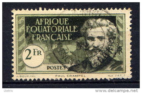
French Equatorial Africa (french: link=no, Afrique-Équatoriale française), or the AEF, was the federation of French colonial possessions in Equatorial Africa, extending northwards from the Congo River into the Sahel, and comprising what are today the countries of Chad, the Central African Republic, the Republic of the Congo, and Gabon. History Established in 1910, the Federation contained four (later five) colonial possessions: French Gabon, French Congo, Ubangi-Shari and French Chad. The Governor-General was based in Brazzaville with deputies in each territory. In 1911, France ceded parts of the territory to German Kamerun as a result of the Agadir Crisis. The territory was returned after Germany's defeat in World War I, while most of Cameroon proper became a French League of Nations mandate not integrated into the AEF. French Equatorial Africa, especially the region of Ubangi-Shari had a similar concession system as the Congo Free State and similar atrocities were also c ... [...More Info...] [...Related Items...] OR: [Wikipedia] [Google] [Baidu] |
Ubangi-Shari
Ubangi-Shari (french: Oubangui-Chari) was a French colony in central Africa, a part of French Equatorial Africa. It was named after the Ubangi and Chari rivers along which it was colonised. It was established on 29 December 1903, from the Upper Ubangi (') and Upper Shari (') territories of the French Congo; renamed the Central African Republic (CAR) on 1 December 1958; and received independence on 13 August 1960.''World Statesmen''.Central African Republic" Accessed 29 Mar 2014. History French activity in the area began in 1889 with the establishment of the outpost Bangi at the head of navigation on the Ubangi. The Upper Ubangi was established as part of the French Congo on 9 December 1891. Despite a France-Congo Free State convention establishing a border around the 4th parallel, the area was contested from 1892 to 1895 with the Congo Free State, which claimed the region as its territory of Ubangi-Bomu ('). The Upper Ubangi was a separate colony from 13 July 1894, ... [...More Info...] [...Related Items...] OR: [Wikipedia] [Google] [Baidu] |


