|
Celaya, Guanajuato
Celaya (; ) is a city and its surrounding municipality in the state of Guanajuato, Mexico, located in the southeast quadrant of the state. It is the third most populous city in the state, with a 2005 census population of 310,413. The municipality for which the city serves as municipal seat, had a population of 415,869. The city is located in the geographic center of the municipality, which has an areal extent of 553.18 km2 (213.58 sq mi) and includes many smaller outlying communities, the largest of which are San Miguel Octopan, Rincón de Tamayo and San Juan de la Vega. There are many smaller towns around Celaya including Rincón de Tamayo, Tarimoro, Villagrán, La Moncada, Panales Jamaica (Cañones), Panales Galera, La Calera, La Estancia, La Noria, Los Fierros, El Acebuche, Cacalote, and Charco Largo. It is also not far away from Cortazar, Salamanca, Salvatierra, Apaseo el Grande, Querétaro City and among others. The city was founded in 1570 as ''Villa de la Puris� ... [...More Info...] [...Related Items...] OR: [Wikipedia] [Google] [Baidu] |
Bajío
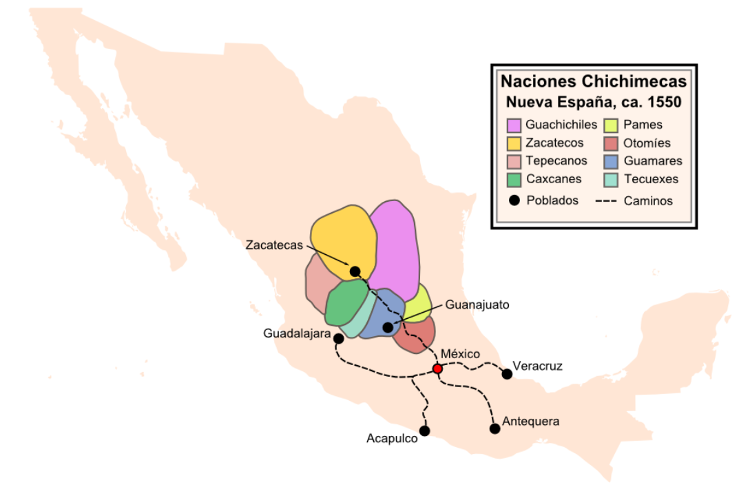
El Bajío (the ''lowland'') is a cultural and geographical region within the central Mexican plateau which roughly spans from north-west of the Mexico City metropolitan area to the main silver mines in the northern-central part of the country. This includes (from south to north) the states of Querétaro, Guanajuato, parts of Jalisco (Centro, Los Altos de Jalisco), Aguascalientes and parts of Zacatecas, San Luis Potosí and Michoacán. Located at the border between Mesoamerica and Aridoamerica, El Bajío saw relatively few permanent settlements and big civilizations during Pre-Columbian history, being mostly inhabited by nomadic tribes known to the Aztecs as " The Chichimeca" peoples (''the barbarians''), another Nahua group from whom the Toltec and the Aztecs were probably descended. The tribes that inhabited El Bajío proved to be some of the hardest to conquer for the Spanish, but due to its strategic location in the Silver route, it also drew prominent attention from ... [...More Info...] [...Related Items...] OR: [Wikipedia] [Google] [Baidu] |
Tarimoro
Tarimoro is the municipal seat of the municipality A municipality is usually a single administrative division having municipal corporation, corporate status and powers of self-government or jurisdiction as granted by national and regional laws to which it is subordinate. The term ''municipality ... of Tarimoro in the Mexican state of Guanajuato. History The original settlement was a community of Otomi people who were later conquered by the '' Tarascós''. The latter named this place Tarimoro, which means "Place of willows." The town was founded back in the epic of colonization by Don Lucas of San Juan on January 3, 1563. In 1910, its name was changed to Ciudad Obregon Gonzalez, by decree of the state Congress, in honor of the then state governor, Joaquin Gonzalez Obregon. However, the official name was later changed back to Tarimoro. Geography and climate Tarimoro is located in Guanajuato. It is bordered to the north by Celaya, to the northwest by Apaseo del Alto, t ... [...More Info...] [...Related Items...] OR: [Wikipedia] [Google] [Baidu] |
Chichimecas
Chichimeca () is the name that the Nahua peoples of Mexico generically applied to nomadic and semi-nomadic peoples who were established in present-day Bajio region of Mexico. Chichimeca carried the meaning as the Roman term "barbarian" that described Germanic tribes. The name, with its pejorative sense, was adopted by the Spanish Empire. For the Spanish, in the words of scholar Charlotte M. Gradie, "the Chichimecas were a wild, nomadic people who lived north of the Valley of Mexico. They had no fixed dwelling places, lived by hunting, wore little clothes and fiercely resisted foreign intrusion into their territory, which happened to contain silver mines the Spanish wished to exploit." In spite of not having temples or idols, they practiced animal sacrifice, and they were feared for their expertise and brutality in war. The Spanish invasion resulted in a "drastic population decline of all the peoples known collectively as Chichimecas, and to the eventual disappearance as peoples ... [...More Info...] [...Related Items...] OR: [Wikipedia] [Google] [Baidu] |
Purépecha People
The Purépecha (endonym pua, P'urhepecha ) are a group of indigenous people centered in the northwestern region of Michoacán, Mexico, mainly in the area of the cities of Cherán and Pátzcuaro. They are also known by the pejorative " Tarascan", an exonym, applied by outsiders and not one they use for themselves. The Purépecha occupied most of Michoacán but also some of the lower valleys of both Guanajuato and Jalisco. Celaya, Acambaro, Cerano, and Yurirapundaro. Now, the Purépecha live mostly in the highlands of central Michoacán, around Lakes Patzcuaro and Cuitzeo. History Prehispanic history It was one of the major empires of the Pre-Columbian era. The capital city was Tzintzuntzan. Purépecha architecture is noted for step pyramids in the shape of the letter "T". Pre-Columbian Purépecha artisans made feather mosaics that extensively used hummingbird feathers, which were highly regarded as luxury goods throughout the region. During the Pre-Colonial era, t ... [...More Info...] [...Related Items...] OR: [Wikipedia] [Google] [Baidu] |
Street Vendors In The Celaya Train Station
A street is a public thoroughfare in a built environment. It is a public parcel of land adjoining buildings in an urban context, on which people may freely assemble, interact, and move about. A street can be as simple as a level patch of dirt, but is more often paved with a hard, durable surface such as tarmac, concrete, cobblestone or brick. Portions may also be smoothed with asphalt, embedded with rails, or otherwise prepared to accommodate non-pedestrian traffic. Originally, the word ''street'' simply meant a paved road ( la, via strata). The word ''street'' is still sometimes used informally as a synonym for ''road'', for example in connection with the ancient Watling Street, but city residents and urban planners draw a crucial modern distinction: a road's main function is transportation, while streets facilitate public interaction. [...More Info...] [...Related Items...] OR: [Wikipedia] [Google] [Baidu] |
Panorama De La Ciudad De Celaya, Guanajuato
A panorama (formed from Greek πᾶν "all" + ὅραμα "view") is any wide-angle view or representation of a physical space, whether in painting, drawing, photography, film, seismic images, or 3D modeling. The word was originally coined in the 18th century by the English (Irish descent) painter Robert Barker to describe his panoramic paintings of Edinburgh and London. The motion-picture term ''panning'' is derived from ''panorama''. A panoramic view is also purposed for multimedia, cross-scale applications to an outline overview (from a distance) along and across repositories. This so-called "cognitive panorama" is a panoramic view over, and a combination of, cognitive spaces used to capture the larger scale. History The device of the panorama existed in painting, particularly in murals, as early as 20 A.D., in those found in Pompeii, as a means of generating an immersive " panoptic" experience of a vista. Cartographic experiments during the Enlightenment era pr ... [...More Info...] [...Related Items...] OR: [Wikipedia] [Google] [Baidu] |
Querétaro City
Santiago de Querétaro (; Otomi: Dähnini Maxei), known simply as Querétaro City ( es, Ciudad de Querétaro), is the capital and largest city of the state of Querétaro, located in central Mexico. It is part of the macroregion of Bajío. It is northwest of Mexico City, southeast of San Miguel de Allende and south of San Luis Potosí. It is also the seat of the municipality of Querétaro, divided into seven boroughs. In 1996, the historic center of Querétaro was declared a World Heritage Site by the UNESCO. The city is a strong business and economic center and a vigorous service center that is experiencing an ongoing social and economic revitalization. All this has resulted in high levels of migration from other parts of Mexico. Querétaro has seen outstanding industrial and economic development since the mid-1990s. Querétaro metropolitan area has the 2nd highest GDP per capita among Mexico's metropolitan areas with US$20,000 after Monterrey. The city is the fastest-growing i ... [...More Info...] [...Related Items...] OR: [Wikipedia] [Google] [Baidu] |
Apaseo El Grande
Apaseo el Grande is a city and municipality located in Guanajuato, Mexico. The municipality covers 415.26 square kilometres (160 sq mi). It is bordered on the north by Comonfort and San Miguel de Allende, on the east by Querétaro, on the south by Apaseo el Alto, and on the west by Celaya. The municipality had a population of 85,319 inhabitants according to the 2010 census. In pre-Columbian times, the region was known as Andahe ("Close to the water") and Atlayahualco ("Place where water flows") by the Otomí and Nahua inhabitants. It was eventually known as Apatzeo ("Yellow flower") by the Purépecha. Following the Spanish conquest 1525, Apaseo was the first town founded in what is now the state of Guanajuato. It received its present name of Apaseo el Grande in 1957, to avoid confusion with the neighboring town of Apaseo el Alto. Etymology The initial name of the town and municipality was Apatzeo, first used by Hernán Pérez de Bocanegra y Córdoba, who was ... [...More Info...] [...Related Items...] OR: [Wikipedia] [Google] [Baidu] |
Salvatierra, Guanajuato
Salvatierra () is a Mexican city (and municipality) located in the valley of Huatzindeo in the lowlands of the state of Guanajuato. It is rich in civil and religious architecture; haciendas, bridges, convents and large houses surrounded in tradition and history. With an area of 507.70 square kilometres, Salvatierra accounts for 1.66% the total area of the state. It is bordered to the north by Tarimoro and Cortazar, to the south by Acámbaro and the state of Michoacán, to the west by Yuriria and Santiago Maravatío, and to the northeast by Jaral del Progreso. The municipality had a total of 94,558 inhabitants of which 34,066 lived in the city of Salvatierra, according to the 2005 census. As of 2020 the municipality had a total of 94,126 inhabitants, compared to 2010, the population in Salvatierra decreased by -3.02% In pre-Columbian times the area was known as Huatzindeo (or Guatzindeo) which means "Place of beautiful vegetation" by the mostly Purépecha inhabitants. In 1646 S ... [...More Info...] [...Related Items...] OR: [Wikipedia] [Google] [Baidu] |
Salamanca, Guanajuato
Salamanca ( Otomi: ''Xidoo'' "Place of Tepetate") is a city in the Mexican state of Guanajuato. Founded January 1, 1603 as 'Villa de Salamanca' by the Viceroy Gaspar de Zuniga and Acevedo, fifth Earl of Monterrey, who was originally from Salamanca (Spain). The town was founded in the lands of Bajio, after cattle ranchers and poor farmers, a few Spaniards, and small groups of Otomi Indians who formerly occupied a village named Xidoo, already lived in the area. In recent years, many refineries have opened, and Salamanca has grown rapidly to become an important site for manufacturing and service industry in the region. Also, the University of Guanajuato has made many scientific contributions to develop agricultural and industrial technologies, giving a boost to the local and regional industries. The city reported a 2020 census population of 273,417. The fourth-largest city in the state (behind León, Irapuato, and Celaya), it is also the largest of four places called "Salamanca" i ... [...More Info...] [...Related Items...] OR: [Wikipedia] [Google] [Baidu] |
Cortazar, Guanajuato
Cortazar is a city and its surrounding municipality located in the southeastern quadrant of the state of Guanajuato in Mexico. It is bordered to the north by Villagrán, to the north and east by Celaya, to the southeast by Tarimoro, to the south by Salvatierra, and to the west by Jaral del Progreso and Salamanca. The city had a 2005 census population of 57,748 inhabitants, while the municipality had a population of 83,175. The municipality has an area of 331.8 km² (128.1 sq mi) and includes many smaller outlying communities, the largest of which are Tierra Fría to the west and La Cañada de Caracheo to the south. In pre-Columbian times the region was inhabited primarily by Otomí and Mexicas people. Founded in 1721 by Franciscan friars, the village of San José de los Amoles was under the order of the congress of Guanajuato given the present name of Cortázar in 1857 after Luis Cortazar y Rábago, a Mexican patriot and leader of Mexico's war of independence against Spa ... [...More Info...] [...Related Items...] OR: [Wikipedia] [Google] [Baidu] |


