|
Cascade-Sierra Province
The Cascade-Sierra province is a physiographic region of mountains in the western United States, east and adjacent to Pacific Border province and west and adjacent to the Basin and Range Province (in the south) and Columbia Plateau Province (in the north). About the region The Cascade-Sierra province stretches approximately from the high desert region of the Mojave Desert in Southern California to just north of the border between British Columbia and the state of Washington. The region is extremely diverse geologically and ecologically and is commonly divided into two regions: the Cascade Mountains and the Sierra Nevada Mountains. This province is part of a larger physiographic region that extends from Alaska in the north to the southern tip of South America. Several tectonic plates meet and form this region and make it one of the most geologically active places in North America. The province is home to several national forests, including the Lassen, Modoc, and Plumas Nat ... [...More Info...] [...Related Items...] OR: [Wikipedia] [Google] [Baidu] |
Mount Shuksan
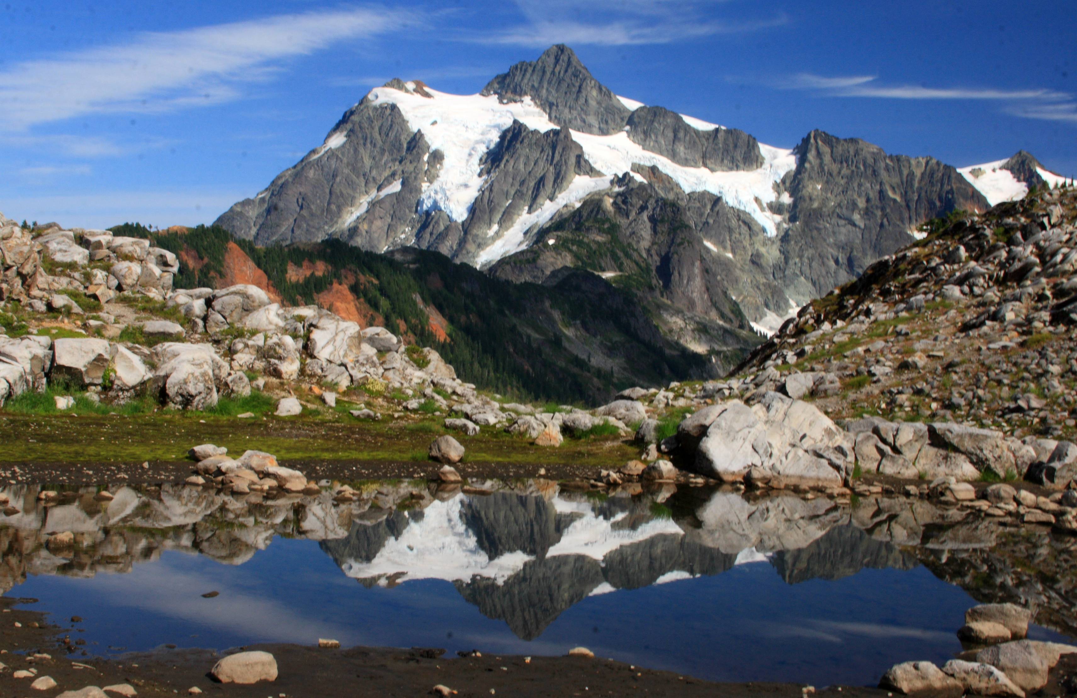
Mount Shuksan is a glaciated massif in the North Cascades National Park. Shuksan rises in Whatcom County, Washington immediately to the east of Mount Baker, and south of the Canada–US border. The mountain's name ''Shuksan'' is derived from the Lummi word '' �éqsən', said to mean "high peak". The highest point on the mountain is a three-sided peak known as Summit Pyramid. The mountain is composed of Shuksan greenschist, oceanic basalt that was metamorphosed when the Easton terrane collided with the west coast of North America, approximately 120 million years ago. The mountain is an eroded remnant of a thrust plate formed by the Easton collision. The Mount Baker Highway, State Route 542, is kept open during the winter to support Mt. Baker Ski Area. In late summer, the road to Artist Point allows visitors to travel a few miles higher for a closer view of the peak. Picture Lake is accessible on the highway and reflects the mountain, making it a popular site for photography. ... [...More Info...] [...Related Items...] OR: [Wikipedia] [Google] [Baidu] |
Modoc Plateau
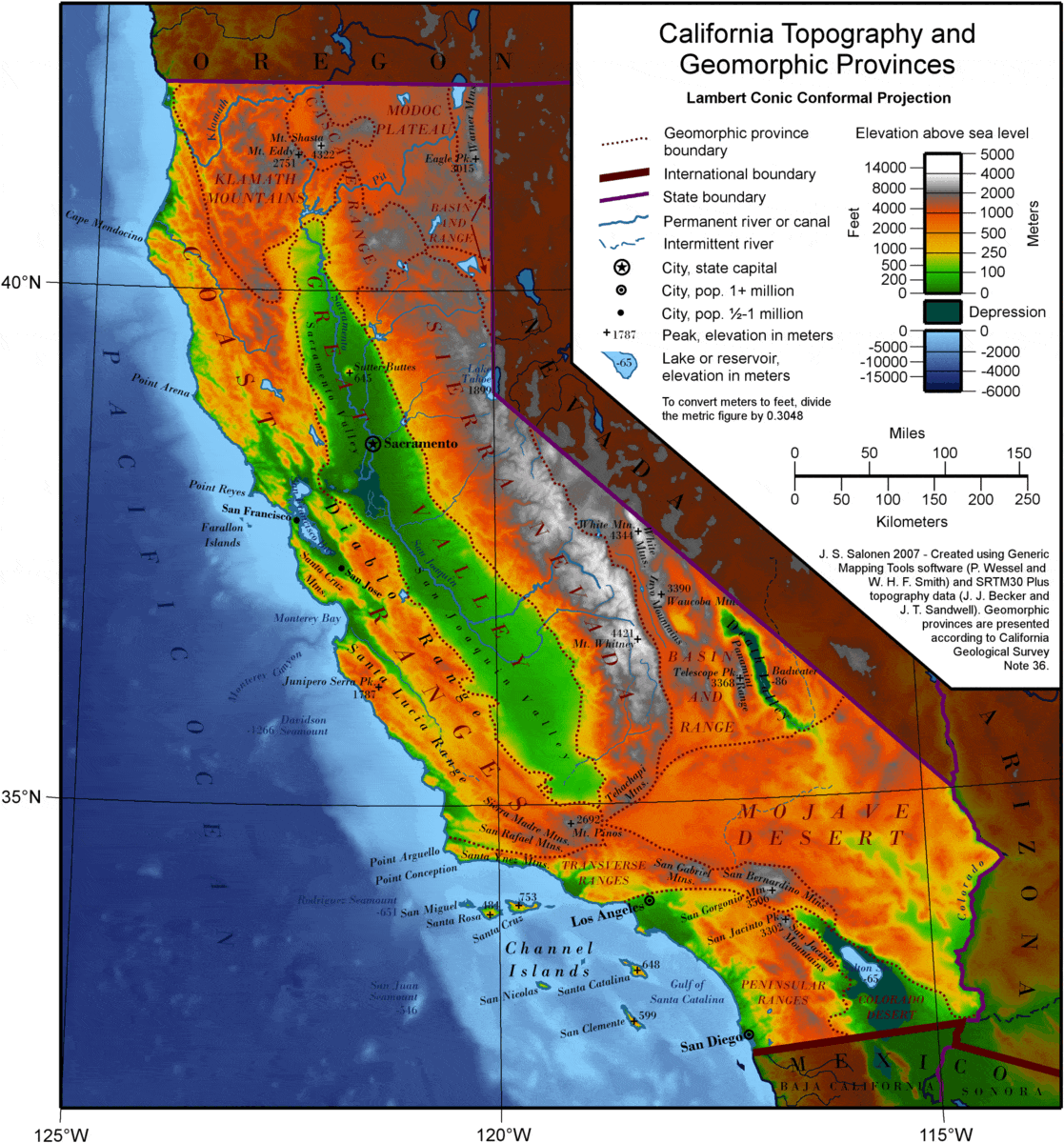
__NOTOC__ The Modoc Plateau lies in the northeast corner of California as well as parts of Oregon and Nevada. Nearly of the Modoc National Forest are on the plateau between the Medicine Lake Highlands in the west and the Warner Mountains in the east. Its landform is volcanic table land ranging from 4,000 to 6,000 feet above sea level, cut by many north–south faults. "Occasioned lakes, marshes, and sluggishly flowing streams meander across the plateau."‘’California Geologic Provinces,’’ Note 36, page 2 It is a thick accumulation of and [...More Info...] [...Related Items...] OR: [Wikipedia] [Google] [Baidu] |
Plate Tectonic
Plate tectonics (from the la, label=Late Latin, tectonicus, from the grc, τεκτονικός, lit=pertaining to building) is the generally accepted scientific theory that considers the Earth's lithosphere to comprise a number of large tectonic plates which have been slowly moving since about 3.4 billion years ago. The model builds on the concept of ''continental drift'', an idea developed during the first decades of the 20th century. Plate tectonics came to be generally accepted by geoscientists after seafloor spreading was validated in the mid to late 1960s. Earth's lithosphere, which is the rigid outermost shell of the planet (the crust and upper mantle), is broken into seven or eight major plates (depending on how they are defined) and many minor plates or "platelets". Where the plates meet, their relative motion determines the type of plate boundary: '' convergent'', '' divergent'', or ''transform''. Earthquakes, volcanic activity, mountain-building, and oceanic tren ... [...More Info...] [...Related Items...] OR: [Wikipedia] [Google] [Baidu] |
Physiographic Regions Of The World
Physiographic regions of the world are a means of defining Earth's landforms into distinct regions, based upon the classic three-tiered approach by Nevin M. Fenneman in 1916, that separates landforms into physiographic divisions, physiographic provinces, and physiographic sections. Originally used in North America, the model became the basis for similar classifications of other continents, and was still considered valid . Physiography During the early 1900s, the study of regional-scale geomorphology was termed "physiography". Physiography later was considered to be a contraction of "''physi''cal" and "ge''ography''", and therefore synonymous with physical geography, and the concept became embroiled in controversy surrounding the appropriate concerns of that discipline. Some geomorphologists held to a geological basis for physiography and emphasized a concept of physiographic regions while a conflicting trend among geographers was to equate physiography with "pure morphology," sepa ... [...More Info...] [...Related Items...] OR: [Wikipedia] [Google] [Baidu] |
Pacific Northwest
The Pacific Northwest (sometimes Cascadia, or simply abbreviated as PNW) is a geographic region in western North America bounded by its coastal waters of the Pacific Ocean to the west and, loosely, by the Rocky Mountains to the east. Though no official boundary exists, the most common conception includes the U.S. states of Oregon, Washington (state), Washington, and Idaho, and the Canadian province of British Columbia. Some broader conceptions reach north into Alaska and Yukon, south into northern California, and east into western Montana. Other conceptions may be limited to the coastal areas west of the Cascade Mountains, Cascade and Coast Mountains, Coast mountains. The variety of definitions can be attributed to partially overlapping commonalities of the region's history, culture, geography, society, ecosystems, and other factors. The Northwest Coast is the coastal region of the Pacific Northwest, and the Northwest Plateau (also commonly known as "British Columbia Interi ... [...More Info...] [...Related Items...] OR: [Wikipedia] [Google] [Baidu] |
Mountain Formation
Mountain formation refers to the geological processes that underlie the formation of mountains. These processes are associated with large-scale movements of the Earth's crust (List of tectonic plates, tectonic plates). Fold (geology), Folding, Fault (geology), faulting, Volcano, volcanic activity, igneous intrusion and metamorphism can all be parts of the Orogeny, orogenic process of mountain building. The formation of mountains is not necessarily related to the structural geology, geological structures found on it. The understanding of specific landscape features in terms of the underlying tectonics, tectonic processes is called ''geomorphology, tectonic geomorphology'', and the study of geologically young or ongoing processes is called ''neotectonics''. From the late 18th century until its replacement by plate tectonics in the 1960s, geosyncline, geosyncline theory was used to explain much mountain-building. Types of mountains There are five main types of mountains: volcani ... [...More Info...] [...Related Items...] OR: [Wikipedia] [Google] [Baidu] |
Geology Of The Yosemite Area
The exposed geology of the Yosemite area includes primarily granitic rocks with some older metamorphic rock. The first rocks were laid down in Precambrian times, when the area around Yosemite National Park was on the edge of a very young North American continent. The sediment that formed the area first settled in the waters of a shallow sea, and compressive forces from a subduction zone in the mid-Paleozoic fused the seabed rocks and sediments, appending them to the continent. Heat generated from the subduction created island arcs of volcanoes that were also thrust into the area of the park. In time, the igneous and sedimentary rocks of the area were later heavily metamorphosed. Most of the rock now exposed in the park is granitic, having been formed 210 to 80 million years ago as igneous diapirs 6 miles (10 km) below the surface. Over time, most of the overlying rock was uplifted along with the rest of the Sierra Nevada and was removed from the area by erosion. This exposed t ... [...More Info...] [...Related Items...] OR: [Wikipedia] [Google] [Baidu] |
Geography Of California
California is a U.S. state on the western coast of North America. Covering an area of , California is among the most geographically diverse states. The Sierra Nevada, the fertile farmlands of the Central Valley, and the arid Mojave Desert of the south are some of the major geographic features of this U.S. state. It is home to some of the world's most exceptional trees: the tallest (coast redwood), most massive (Giant Sequoia), and oldest (bristlecone pine). It is also home to both the highest (Mount Whitney) and lowest (Death Valley) points in the 48 contiguous states. The state is generally divided into Northern and Southern California, although the boundary between the two is not well defined. San Francisco is decidedly a Northern California city and Los Angeles likewise a Southern California one, but areas in between do not often share their confidence in geographic identity. The US Geological Survey defines the geographic center of the state at a point near North Fork, Calif ... [...More Info...] [...Related Items...] OR: [Wikipedia] [Google] [Baidu] |
Fault (geology)
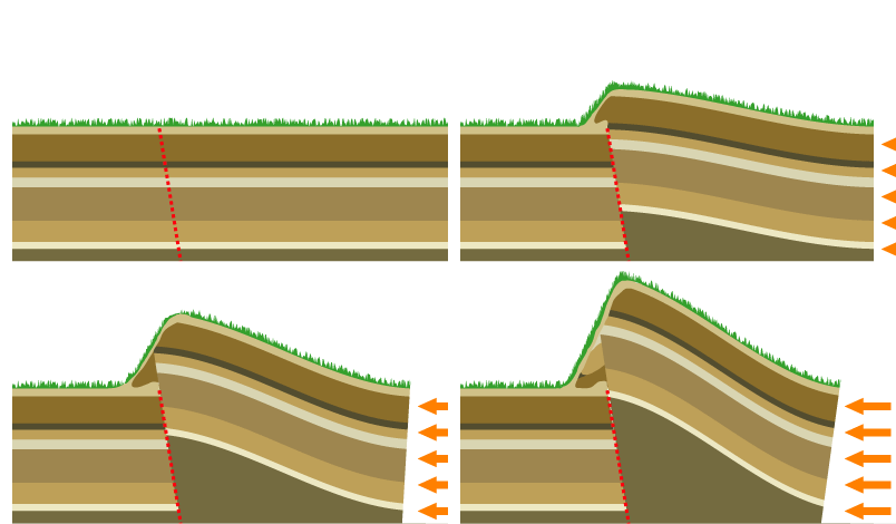
In geology, a fault is a planar fracture or discontinuity in a volume of rock across which there has been significant displacement as a result of rock-mass movements. Large faults within Earth's crust result from the action of plate tectonic forces, with the largest forming the boundaries between the plates, such as the megathrust faults of subduction zones or transform faults. Energy release associated with rapid movement on active faults is the cause of most earthquakes. Faults may also displace slowly, by aseismic creep. A ''fault plane'' is the plane that represents the fracture surface of a fault. A ''fault trace'' or ''fault line'' is a place where the fault can be seen or mapped on the surface. A fault trace is also the line commonly plotted on geologic maps to represent a fault. A ''fault zone'' is a cluster of parallel faults. However, the term is also used for the zone of crushed rock along a single fault. Prolonged motion along closely spaced faults can blur the ... [...More Info...] [...Related Items...] OR: [Wikipedia] [Google] [Baidu] |
Yosemite National Park
Yosemite National Park ( ) is an American national park in California, surrounded on the southeast by Sierra National Forest and on the northwest by Stanislaus National Forest. The park is managed by the National Park Service and covers an area of and sits in four County, countiescentered in Tuolumne County, California, Tuolumne and Mariposa County, California, Mariposa, extending north and east to Mono County, California, Mono and south to Madera County, California, Madera County. Designated a World Heritage Site in 1984, Yosemite is internationally recognized for its granite cliffs, waterfalls, clear streams, Sequoiadendron giganteum, giant sequoia groves, lakes, mountains, meadows, glaciers, and Biodiversity, biological diversity. Almost 95 percent of the park is designated National Wilderness Preservation System, wilderness. Yosemite is one of the largest and least fragmented habitat blocks in the Sierra Nevada, and the park supports a diversity of plants and animals. The ... [...More Info...] [...Related Items...] OR: [Wikipedia] [Google] [Baidu] |
1980 Eruption Of Mount St
__NOTOC__ Year 198 (CXCVIII) was a common year starting on Sunday (link will display the full calendar) of the Julian calendar. At the time, it was known as the Year of the Consulship of Sergius and Gallus (or, less frequently, year 951 ''Ab urbe condita''). The denomination 198 for this year has been used since the early medieval period, when the Anno Domini calendar era became the prevalent method in Europe for naming years. Events By place Roman Empire *January 28 **Publius Septimius Geta, son of Septimius Severus, receives the title of Caesar. **Caracalla, son of Septimius Severus, is given the title of Augustus. China *Winter – Battle of Xiapi: The allied armies led by Cao Cao and Liu Bei defeat Lü Bu; afterward Cao Cao has him executed. By topic Religion * Marcus I succeeds Olympianus as Patriarch of Constantinople (until 211). Births * Lu Kai (or Jingfeng), Chinese official and general (d. 269) * Quan Cong, Chinese general and advisor (d. ... [...More Info...] [...Related Items...] OR: [Wikipedia] [Google] [Baidu] |
Lassen Peak
Lassen Peak ( ), commonly referred to as Mount Lassen, is a lava dome volcano and the southernmost active volcano in the Cascade Range of the Western United States. Located in the Shasta Cascade region of Northern California, it is part of the Cascade Volcanic Arc, which stretches from southwestern British Columbia to northern California. Lassen Peak reaches an elevation of , standing above the northern Sacramento Valley. It supports many flora and fauna among its diverse habitats, which are subject to frequent snowfall and reach high elevations. Lassen Peak has a volume of , making it one of the largest lava domes on Earth. The volcano arose from the former northern flank of now-eroded Mount Tehama about 27,000 years ago, from a series of eruptions over the course of a few years. The mountain has been significantly eroded by glaciers over the last 25,000 years, and is now covered in talus deposits. On May 22, 1915, a powerful explosive eruption at Lassen Peak devastated near ... [...More Info...] [...Related Items...] OR: [Wikipedia] [Google] [Baidu] |


