|
Carnetown
Carnetown (or 'Carne') is a district of Abercynon, within the Cynon Valley in the County Borough of Rhondda Cynon Taf Rhondda Cynon Taf (; RCT; also spelt as Rhondda Cynon Taff) is a county borough in the south-east of Wales. It consists of five valleys: the Rhondda Fawr, Rhondda Fach, Cynon, Taff (Welsh: ''Taf'') and Ely valleys, plus a number of towns and vil ..., Wales. Carnetown is located to the south and west of Abercynon, and comprises Carnetown itself to the west, and the large modern housing estate of 'Grovers Field' to the south. The area is home to 'Carnetown Primary School', 'St. Donat's Church' (built in 1898), 'Carne Park Hotel' and various shops/businesses, and previously had its own post office until 2005. Gallery Image:Grove Field Estate - geograph.org.uk - 564649.jpg, Grovers Field References {{authority control Villages in Rhondda Cynon Taf ... [...More Info...] [...Related Items...] OR: [Wikipedia] [Google] [Baidu] |
Abercynon
Abercynon (), is both a village and a community (and electoral ward) in the Cynon Valley within the unitary authority of Rhondda Cynon Taf, Wales. The community comprises the village and the districts of Carnetown and Grovers Field to the south, Navigation Park to the east, and Glancynon (or Aber-taf) to the north. The population of Abercynon was recorded as 6,428 in the 2001 Census,Davies (2008), p.4 decreasing to 6,390 at the 2011 Census, despite more than a hundred additional households built over this period (from 2,582 in 2011 to 2,694 by 2011). The electoral ward of Abercynon includes both the community of Abercynon, but also takes into account the nearby villages of Pontcynon, Ynysboeth and Tyntetown further north. Abercynon is approximately north of Cardiff and approximately from Swansea. The rivers Taff and Cynon converge at Watersmeet near Martin's Terrace. Abercynon used to have many churches, chapels and pubs. There are now only four public houses left - The Tho ... [...More Info...] [...Related Items...] OR: [Wikipedia] [Google] [Baidu] |
Cynon Valley
Cynon Valley () is a former coal mining valley in Wales. Cynon Valley lies between Rhondda and the Merthyr Valley and takes its name from the River Cynon. Aberdare is located in the north of the valley and Mountain Ash is in the south of the valley. From 1974 to 1996 Cynon Valley was a local government district. According to the 2001 census, the Cynon Valley has a population of 63,512. In 2001 12.1% of the inhabitants were recorded as Welsh speakers. In common with some of the other South Wales Valleys, Cynon Valley had a high percentage of Welsh speakers until the early 20th century. Former district From 1974 to 1996 the Borough of Cynon Valley was one of thirty-seven districts of Wales. The district was formed from the Aberdare and Mountain Ash urban districts, the parish of Rhigos from Neath Rural District and the parish of Penderyn from Brecknockshire. It was one of six districts of Mid Glamorgan, and in 1996 was merged into the larger unitary authority of Rhondda ... [...More Info...] [...Related Items...] OR: [Wikipedia] [Google] [Baidu] |
Cynon Valley (UK Parliament Constituency)
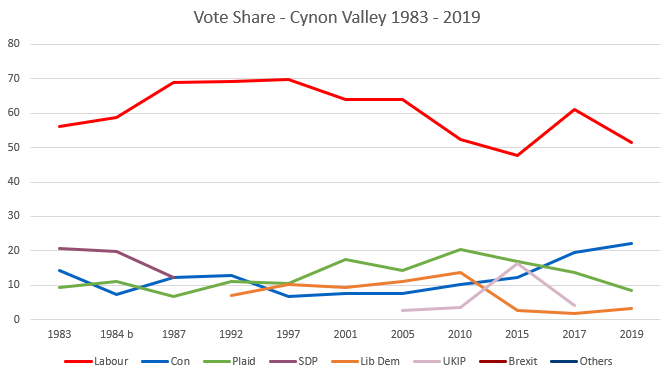
Cynon Valley ( cy, Cwm Cynon) is a constituency represented in the House of Commons of the UK Parliament since 2019 by Beth Winter of the Labour Party. The Cynon Valley Senedd constituency was created with the same boundaries in 1999 (as an Assembly constituency). Boundaries 1983–2010: The Borough of Cynon Valley. 2010–present: The Rhondda Cynon Taff County Borough electoral divisions of Aberaman North, Aberaman South, Abercynon, Aberdare East, Aberdare West/Llwydcoed, Cilfynydd, Cwmbach, Glyncoch, Hirwaun, Mountain Ash East, Mountain Ash West, Penrhiwceiber, Pen-y-waun, Rhigos, and Ynysybwl. The constituency encompasses the towns of Aberdare, Mountain Ash, Cilfynydd, Abercynon and Hirwaun. Members of Parliament Elections Elections in the 1980s * Death of Ioan Evans 10 February 1984 Elections in the 1990s Elections in the 2000s Elections in the 2010s ... [...More Info...] [...Related Items...] OR: [Wikipedia] [Google] [Baidu] |
Rhondda Cynon Taf
Rhondda Cynon Taf (; RCT; also spelt as Rhondda Cynon Taff) is a county borough in the south-east of Wales. It consists of five valleys: the Rhondda Fawr, Rhondda Fach, Cynon, Taff (Welsh: ''Taf'') and Ely valleys, plus a number of towns and villages away from the valleys. Results from the 2011 census showed 19.1% of its 234,410 residents self-identified as having some ability in the use of the Welsh language. The county borough borders Merthyr Tydfil County Borough and Caerphilly County Borough to the east, Cardiff and the Vale of Glamorgan to the south, Bridgend County Borough and Neath Port Talbot to the west and Powys to the north. Its principal towns are - Aberdare, Llantrisant with Talbot Green and Pontypridd, with other key settlements/towns being - Maerdy, Ferndale, Hirwaun, Llanharan, Mountain Ash, Porth, Tonypandy, Tonyrefail and Treorchy. The most populous individual town in Rhondda Cynon Taf is Aberdare ( cy, Aberdâr) with a population of 39,550 (2011), followed ... [...More Info...] [...Related Items...] OR: [Wikipedia] [Google] [Baidu] |
Mid Glamorgan
, Government= Mid Glamorgan County Council , Status= Non-metropolitan county (1974–1996) Preserved county (1996–) , Start= 1974 , End= 1996 , Arms= ''Coat of arms of Mid Glamorgan County Council'' , Replace= Bridgend Merthyr Tydfil Rhondda Cynon Taff Caerphilly Preserved county of Mid Glamorgan , Map= ''Mid Glamorgan shown within Wales as a preserved county'' , PopulationLast= 423,200 (est; 2003 borders) Ranked 4th , PopulationLastYear= 2007 , AreaFirst= Ranked 7th , AreaFirstYear= 2003 , AreaLast= , AreaLastYear= , Divisions= Non-metropolitan districts , DivisionsNames= 1. Cynon Valley 2. Ogwr 3. Merthyr Tydfil 4. Rhondda 5. Rhymney Valley 6. Taff-Ely , HQ = County Hall, Cathays Park, Cardiff (extraterritorial) Mid Glamorgan ( cy, Morgannwg Ganol) is a preserved county of Wales. From 1974 until 1996 ... [...More Info...] [...Related Items...] OR: [Wikipedia] [Google] [Baidu] |
Cynon Valley (National Assembly For Wales Constituency)
, constituency_type = Senedd county constituency , parl_name=Senedd, image = , image2 = , caption2 = Cynon Valley shown within the South Wales Central electoral region and the region shown within Wales , year = 1999 , member_label = MS , member = Vikki Howells , party_label = Party , party = Welsh Labour , parts_label = Preserved county , parts = Mid Glamorgan Cynon Valley ( cy, Cwm Cynon) is a constituency of the Senedd. It elects one Member of the Senedd by the first past the post method of election. It is also one of eight constituencies in the South Wales Central electoral region, which elects four additional members, in addition to eight constituency members, to produce a degree of proportional representation for the region as a whole. Boundaries The constituency was created for the first election to the Assembly, in 1999, with the name and boundaries of the ... [...More Info...] [...Related Items...] OR: [Wikipedia] [Google] [Baidu] |
Pontcynon
Pontcynon is a small village of around 200 households within the Cynon Valley in the County Borough of Rhondda Cynon Taf, Wales, near Abercynon. Most of the village consists of terraced housing fronting the B4275 Abercynon Road; but also consists of the adjoining streets of Pontcynon Terrace, Vale View and Cemetery Road. Geography Pontcynon is located along the B4275, and is bounded by the village of Abercynon just under a mile to the south, by the A4059 to the east and by Quakers Yard beyond, and by Ynysboeth to the northwest. Although at one time considered an outlying district of the community of Abercynon, the sign signifying the southbound approach to Abercynon is today located south of the village at a point where there is a 150m break between the terraced housing along Abercynon Road, the start and end of which indicating the boundaries of the village and of Abercynon. Pontcynon however remains part of the electoral ward of Abercynon. The village is noted for its bridg ... [...More Info...] [...Related Items...] OR: [Wikipedia] [Google] [Baidu] |
Ynysybwl
Ynysybwl ( cy, Ynys-y-bŵl ) is a village in Cwm Clydach in Wales. It is situated in the county borough of Rhondda Cynon Taf, roughly north-north-west of Cardiff, north of Pontypridd and south of Merthyr Tydfil, and forms part of the community of Ynysybwl and Coed-y-Cwm. Cwm Clydach is flanked by the Rhondda and Cynon Valleys. The market town of Pontypridd lies to the south at the meeting point of the three valleys; and to the north lies the large Llanwynno forestry. Before the local government reforms of 1996 Ynysybwl was in the Cynon Valley district of Morgannwg Ganol, and the area is historically a part of Glamorgan (Morgannwg). Name There is uncertainty over the meaning of the name of the village. ''Ynys'' means 'island' or 'river meadow' in Welsh and probably refers to such a meadow on the banks of the Clydach stream. The 'bŵl' element is more difficult. Some theories include 'bowl/ball' ee 'bŵl' GPCpossibly a reference to the shape of the river-meadow ... [...More Info...] [...Related Items...] OR: [Wikipedia] [Google] [Baidu] |


