|
Caribou Tuya
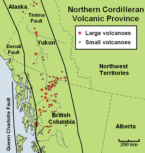
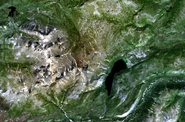
Caribou Tuya is a basaltic subglacial mound in far northwestern British Columbia that began eruptive activity under glacial ice during the Fraser glaciation (25 to 10 Annum, ka). Like Ash Mountain (British Columbia), Ash Mountain and South Tuya, sections of the subglacial mound reveal a consistent stratigraphic progression from pillow lavas to hyaloclastite deposits from the base upward. Locally the sections are capped by subaerial basaltic lava flows. Samples of the glassy pillow basalts and hyaloclastites along with crystalline basalt flows were collected at Caribou Tuya. The volcano is believed to have formed and last erupted during the Pleistocene Epoch. See also *List of volcanoes in Canada *List of Northern Cordilleran volcanoes *Volcanism of Canada *Volcanism of Western Canada *Volcanic history of the Northern Cordilleran Volcanic Province References Cassiar Country One-thousanders of British Columbia Volcanoes of British Columbia Subglacial mounds of Canada Northe ... [...More Info...] [...Related Items...] OR: [Wikipedia] [Google] [Baidu] |
British Columbia
British Columbia (commonly abbreviated as BC) is the westernmost province of Canada, situated between the Pacific Ocean and the Rocky Mountains. It has a diverse geography, with rugged landscapes that include rocky coastlines, sandy beaches, forests, lakes, mountains, inland deserts and grassy plains, and borders the province of Alberta to the east and the Yukon and Northwest Territories to the north. With an estimated population of 5.3million as of 2022, it is Canada's third-most populous province. The capital of British Columbia is Victoria and its largest city is Vancouver. Vancouver is the third-largest metropolitan area in Canada; the 2021 census recorded 2.6million people in Metro Vancouver. The first known human inhabitants of the area settled in British Columbia at least 10,000 years ago. Such groups include the Coast Salish, Tsilhqotʼin, and Haida peoples, among many others. One of the earliest British settlements in the area was Fort Victoria, established ... [...More Info...] [...Related Items...] OR: [Wikipedia] [Google] [Baidu] |
Lava Flows
Lava is molten or partially molten rock (magma) that has been expelled from the interior of a terrestrial planet (such as Earth) or a moon onto its surface. Lava may be erupted at a volcano or through a fracture in the crust, on land or underwater, usually at temperatures from . The volcanic rock resulting from subsequent cooling is also often called ''lava''. A lava flow is an outpouring of lava during an effusive eruption. (An explosive eruption, by contrast, produces a mixture of volcanic ash and other fragments called tephra, not lava flows.) The viscosity of most lava is about that of ketchup, roughly 10,000 to 100,000 times that of water. Even so, lava can flow great distances before cooling causes it to solidify, because lava exposed to air quickly develops a solid crust that insulates the remaining liquid lava, helping to keep it hot and inviscid enough to continue flowing. The word ''lava'' comes from Italian and is probably derived from the Latin word ''labes'' ... [...More Info...] [...Related Items...] OR: [Wikipedia] [Google] [Baidu] |
Stikine Ranges
The Stikine Ranges are a group of mountain ranges and mountainous plateaus in northwestern British Columbia, Canada. They are the northernmost subdivision of the Cassiar Mountains and among the least explored and most undeveloped parts of the province. The Sifton Ranges, which are also part of the Cassiar Mountains, lie immediately east of the Stikine Ranges just north of the Finlay River; northwest of there the larger Kechika Ranges lie between the Stikine Ranges and the Rocky Mountain Trench. The Stikine Plateau lies to the west of the Stikine Ranges. Extent The ranges run on a NW-SE axis from the Yukon boundary, adjacent to the Nisutlin Plateau at c. , to the Finlay River at c. . Sub-ranges * Beady Range *Nisutlin Plateau* * Skree Range * Three Sisters Range * Thudaka Range *Tuya Range The Tuya Range is a mountain range in the Stikine Ranges of the Cassiar Mountains in the far north of the Canadian province of British Columbia, near its border with the Yukon Territo ... [...More Info...] [...Related Items...] OR: [Wikipedia] [Google] [Baidu] |
Subglacial Mounds Of Canada
Subglacial means "formed, or occurring beneath a glacier or other body of ice". It may refer to: * Subglacial eruption * Subglacial lake * Subglacial stream * Subglacial volcano A subglacial volcano, also known as a glaciovolcano, is a volcanic form produced by subglacial eruptions or eruptions beneath the surface of a glacier or ice sheet which is then melted into a lake by the rising lava. Today they are m ... {{Disambiguation Glaciology ... [...More Info...] [...Related Items...] OR: [Wikipedia] [Google] [Baidu] |
Volcanoes Of British Columbia
British Columbia is the westernmost province of Canada, bordered by the Pacific Ocean. With an area of it is Provinces and territories of Canada, Canada's third-largest province. The province is almost four times the size of the United Kingdom and larger than every States of the United States, United States state except Alaska. It is bounded on the northwest by the U.S. state of Alaska, directly north by Yukon and the Northwest Territories, on the east by Alberta, and on the south by the U.S. states of Washington (state), Washington, Idaho, and Montana. Formerly part of the British Empire, the southern border of British Columbia was established by the 1846 Oregon Treaty. The province is dominated by mountain ranges, among them the Canadian Rockies but dominantly the Coast Mountains, Cassiar Mountains, and the Columbia Mountains. Most of the population is concentrated on the Pacific Ocean, Pacific coast, notably in the area of Vancouver, located on the southwestern tip of the main ... [...More Info...] [...Related Items...] OR: [Wikipedia] [Google] [Baidu] |
Cassiar Country
The Cassiar Country, also referred to simply as the Cassiar, is a historical geographic region of the Canadian province of British Columbia. The Cassiar is located in the northwest portion of British Columbia, just to the northeast of the Stikine Country, while to the south is the Omineca Country. The area is noted for the Cassiar gold rush of the 1870s, when Laketon became its unofficial capital. The ghost town of Cassiar is also located in the Cassiar region. Collins Telegraph Line In the early 1860s, Perry Collins obtained financing from Western Union Telegraph to build a telegraph line from San Francisco through British Columbia and Alaska and across the Bering Strait to Russia and ultimately Europe. The line was begun in 1865 at New Westminster, and continued as far as the Skeena River in 1866, but then the project was abandoned as the transatlantic line was built first, making the Collins line redundant. Despite the fact that the Collins line would not be complet ... [...More Info...] [...Related Items...] OR: [Wikipedia] [Google] [Baidu] |
Volcanic History Of The Northern Cordilleran Volcanic Province
The volcanic history of the Northern Cordilleran Volcanic Province presents a record of volcanic activity in northwestern British Columbia, central Yukon and the U.S. state of easternmost Alaska. The volcanic activity lies in the northern part of the Western Cordillera of the Pacific Northwest region of North America. Extensional cracking of the North American Plate in this part of North America has existed for millions of years. Continuation of this continental rifting has fed scores of volcanoes throughout the Northern Cordilleran Volcanic Province over at least the past 20 million years (see Geology of the Pacific Northwest) and occasionally continued into geologically recent times. Eruptive activity in the Northern Cordilleran Volcanic Province throughout its 20 million year history has been mainly the production of alkaline lavas, including alkaline basalts. A range of alkaline rock types not commonly found in the Western Cordillera are regionally widespread in th ... [...More Info...] [...Related Items...] OR: [Wikipedia] [Google] [Baidu] |
Volcanism Of Western Canada
Volcanism of Western Canada has produced lava flows, lava plateaus, lava domes, cinder cones, stratovolcanoes, shield volcanoes, greenstone belts, submarine volcanoes, calderas, diatremes and maars, along with examples of more less common volcanic forms such as tuyas and subglacial mound A subglacial mound (SUGM) is a type of subglacial volcano. This type of volcano forms when lava erupts beneath a thick glacier or ice sheet. The magma forming these volcanoes was not hot enough to melt a vertical pipe right through the overlying g ...s. Volcanic belts * * * * * * * * * External links Erica A. Massey: A Comparative Study of Glaciovolcanic Palagonitization of Tholeitic and Alkaline Sideromelane in Helgafell, Icland, and Wells Gray-Clearwater Volcanic Filed, BC, Canada. B.Sc., The University of British Columbia, 2014 Volcanic fields * * * See also * * * * ReferencesVolcanoes of Canada . . . . {{Manitoba-geo-stub ... [...More Info...] [...Related Items...] OR: [Wikipedia] [Google] [Baidu] |
Volcanism Of Canada
Volcanism, Volcanic activity is a major part of the geology of Canada and is characterized by many types of volcanic landform, including lava flows, volcanic plateaus, lava domes, cinder cones, stratovolcanoes, shield volcanoes, submarine volcanoes, calderas, diatremes, and maars, along with less common volcanic forms such as tuyas and subglacial mounds. Though Canada's volcanic history dates back to the Precambrian eon, at least 3.11 billion years ago, when its part of the North American continent began to form, volcanism continues to occur in Western Canada, Western and Northern Canada in modern times, where it forms part of an encircling chain of volcanoes and frequent earthquakes around the Pacific Ocean called the Pacific Ring of Fire. Because volcanoes in Western and Northern Canada are in relatively remote and sparsely populated areas and their activity is less frequent than with other volcanoes around the Pacific Ocean, Canada is commonly thought to occupy a gap in th ... [...More Info...] [...Related Items...] OR: [Wikipedia] [Google] [Baidu] |
List Of Northern Cordilleran Volcanoes
The geography of northwestern British Columbia and Yukon, Canada is dominated by volcanoes of the Northern Cordilleran Volcanic Province formed due to continental rifting of the North American Plate. It is the most active volcanic region in Canada. Some of the volcanoes are notable for their eruptions, for instance, Tseax Cone for its catastrophic eruption estimated to have occurred in the 18th century which was responsible for the death of at least 2,000 Nisga'a people from poisonous volcanic gases, the Mount Edziza volcanic complex for at least 20 eruptions throughout the past 10,000 years, and The Volcano (also known as Lava Fork volcano) for the most recent eruption in Canada during 1904. The majority of volcanoes in the Northern Cordilleran Volcanic Province lie in Canada while a very small portion of the volcanic province lies in the U.S. state of Alaska. Volcanoes of the Northern Cordilleran Volcanic Province are a part of the Pacific Ring of Fire. The larg ... [...More Info...] [...Related Items...] OR: [Wikipedia] [Google] [Baidu] |
List Of Volcanoes In Canada
List of volcanoes in Canada is an incomplete list of volcanoes found in Mainland Canada, in the Canadian islands and in Canadian waters. All but one province, Prince Edward Island, have at least one volcano. Alberta British Columbia New Brunswick Newfoundland and Labrador Northwest Territories Nova Scotia Nunavut Ontario Quebec Saskatchewan Yukon See also * Outline of Canada * Bibliography of Canada * Index of Canada-related articles * Volcanism of Canada ** Volcanism of Northern Canada ** Volcanism of Western Canada ** Volcanism of Eastern Canada ** List of Northern Cordilleran volcanoes * List of mountains in Canada * List of Cascade volcanoes External links Catalogue of Canadian Volcanoes {{Canadian volcanism Canada Volcanoes Volcanoes Volcanoes A volcano is a rupture in the crust of a planetary-mass object, such as Earth, that allows hot lava, volcanic ash, and gases to escape from a magma chamber below the surface. ... [...More Info...] [...Related Items...] OR: [Wikipedia] [Google] [Baidu] |


