|
Cape Hooker (Antarctica)
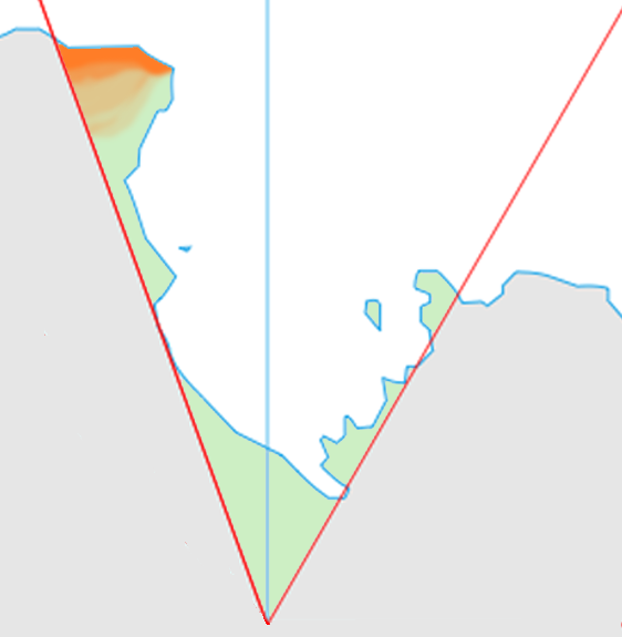
Cape Hooker () is a cape on the northeastern portion of the peninsula which includes Davis Ice Piedmont, on the north coast of Victoria Land, Antarctica.Cape Dayman lies situated to the immediate east-southeast, forming an outer entrance point to Yule Bay. This headland was first discovered by Captain James Clark Ross in 1841, who named it for Joseph Dalton Hooker (later Sir Joseph), naturalist and assistant surgeon on the ''Erebus'' who became internationally famous as a botanist. This headland lies situated on the Pennell Coast, a portion of Antarctica lying between Cape Williams Cape Williams () is an ice-covered cape in Antarctica. It is the termination of Buell Peninsula at the east side of the terminus of Lillie Glacier at the lower ends of George Glacier and Zykov Glacier. The peninsula is 15 nautical miles (28 ... and Cape Adare. References Headlands of Victoria Land Pennell Coast {{VictoriaLand-geo-stub ... [...More Info...] [...Related Items...] OR: [Wikipedia] [Google] [Baidu] |
Davis Ice Piedmont
Davis Ice Piedmont () is an ice piedmont about long and wide, located along the north side of Missen Ridge on the north coast of Victoria Land, Antarctica. The name ''Cape Davis'', after John E. Davis, Second Master of the ''Terror'', was given to a cape in the immediate area by Captain James C. Ross in 1841. Since no significant cape exists here, the Advisory Committee on Antarctic Names and the New Zealand Antarctic Place-Names Committee have reapplied the name "Davis" to this ice piedmont. The geographical feature lies situated on the Pennell Coast, a portion of Antarctica lying between Cape Williams and Cape Adare. References See also *Nella Island Davis Ice Piedmont () is an ice piedmont about long and wide, located along the north side of Missen Ridge on the north coast of Victoria Land, Antarctica. The name ''Cape Davis'', after John E. Davis, Second Master of the ''Terror'', was giv ... Ice piedmonts of Antarctica Landforms of Victoria Land Pennell Coas ... [...More Info...] [...Related Items...] OR: [Wikipedia] [Google] [Baidu] |
Victoria Land
Victoria Land is a region in eastern Antarctica which fronts the western side of the Ross Sea and the Ross Ice Shelf, extending southward from about 70°30'S to 78°00'S, and westward from the Ross Sea to the edge of the Antarctic Plateau. It was discovered by Captain James Clark Ross in January 1841 and named after Queen Victoria. The rocky promontory of Minna Bluff is often regarded as the southernmost point of Victoria Land, and separates the Scott Coast to the north from the Hillary Coast of the Ross Dependency to the south. The region includes ranges of the Transantarctic Mountains and the McMurdo Dry Valleys (the highest point being Mount Abbott in the Northern Foothills), and the flatlands known as the Labyrinth. The Mount Melbourne is an active volcano in Victoria Land. Early explorers of Victoria Land include James Clark Ross and Douglas Mawson. In 1979, scientists discovered a group of 309 meteorites A meteorite is a solid piece of debris from an ... [...More Info...] [...Related Items...] OR: [Wikipedia] [Google] [Baidu] |
Antarctica
Antarctica () is Earth's southernmost and least-populated continent. Situated almost entirely south of the Antarctic Circle and surrounded by the Southern Ocean, it contains the geographic South Pole. Antarctica is the fifth-largest continent, being about 40% larger than Europe, and has an area of . Most of Antarctica is covered by the Antarctic ice sheet, with an average thickness of . Antarctica is, on average, the coldest, driest, and windiest of the continents, and it has the highest average elevation. It is mainly a polar desert, with annual precipitation of over along the coast and far less inland. About 70% of the world's freshwater reserves are frozen in Antarctica, which, if melted, would raise global sea levels by almost . Antarctica holds the record for the lowest measured temperature on Earth, . The coastal regions can reach temperatures over in summer. Native species of animals include mites, nematodes, penguins, seals and tardigrades. Where ve ... [...More Info...] [...Related Items...] OR: [Wikipedia] [Google] [Baidu] |
Cape Dayman
Tapsell Foreland () is a borad, mostly snow-covered foreland jutting into the sea between Yule Bay and Smith Inlet, northern Victoria Land. Much of the central portion of this feature rises above . Exploration and naming The name Tapsell, applied by New Zealand Antarctic Place-Names Committee (NZ-APC) in 1969, is the surname of the Master of the barque ''Brisk'', one of the whaling vessels based on Enderby Settlement at Port Ross, Auckland Islands, 1849–52. In an exploratory voyage in February 1850, Tapsell sailed south to the Balleny Islands and then west along the parallel of 67°S as far as 143°E. No land was sighted. Location Tapsell Foreland extends eastward into the Pacific Ocean to the south of Yule Bay and the Lyall Islands, and to the north of Barnett Glacier, which empties into Smith Inlet. The Kirkby Glacier flows north past its west end. Glaciers rising on the foreland include O'Hara Glacier and Fortenberry Glacier, which flow north, and McElroy Glacier w ... [...More Info...] [...Related Items...] OR: [Wikipedia] [Google] [Baidu] |
Yule Bay
Yule Bay is a bay indenting the coast of northern Victoria Land between Cape Hooker and Cape Dayman. An inner (western) portion of the bay is circumscribed by Bates Point and Ackroyd Point. Discovered by Captain James Clark Ross, 1841, who named it for Henry B. Yule, Second Master Second master was a rating introduced into the Royal Navy in 1753 that indicated a deputy master on third-rate ships of the line or larger. Second masters were paid significantly more than master's mate Master's mate is an obsolete rating whic ... on . In 2020 a penguin colony has been sighted at the bay. References Bays of Victoria Land Pennell Coast {{PennellCoast-geo-stub ... [...More Info...] [...Related Items...] OR: [Wikipedia] [Google] [Baidu] |
James Clark Ross
Sir James Clark Ross (15 April 1800 – 3 April 1862) was a British Royal Navy officer and polar explorer known for his explorations of the Arctic, participating in two expeditions led by his uncle Sir John Ross, John Ross, and four led by Sir William Parry, William Edward Parry, and, in particular, for Ross expedition, his own Antarctic expedition from 1839 to 1843. Biography Early life Ross was born in London, the son of George Ross and nephew of Sir John Ross, John Ross, under whom he entered the Royal Navy on 5 April 1812. Ross was an active participant in the Napoleonic Wars, being present at an action where HMS Briseis (1808), HMS ''Briseis'', commanded by his uncle, captured ''Le Petit Poucet'' (a French privateer) on 9 October 1812. Ross then served successively with his uncle on HMS Acteon (1805), HMS ''Actaeon'' and HMS Driver (1840), HMS ''Driver''. Arctic exploration Ross participated in John's unsuccessful first Arctic voyage in search of a Northwest ... [...More Info...] [...Related Items...] OR: [Wikipedia] [Google] [Baidu] |
Joseph Dalton Hooker
Sir Joseph Dalton Hooker (30 June 1817 – 10 December 1911) was a British botanist and explorer in the 19th century. He was a founder of geographical botany and Charles Darwin's closest friend. For twenty years he served as director of the Royal Botanical Gardens, Kew, succeeding his father, William Jackson Hooker, and was awarded the highest honours of British science. Biography Early years Hooker was born in Halesworth, Suffolk, England. He was the second son of the famous botanist Sir William Jackson Hooker, Regius Professor of Botany, and Maria Sarah Turner, eldest daughter of the banker Dawson Turner and sister-in-law of Francis Palgrave. From age seven, Hooker attended his father's lectures at Glasgow University, taking an early interest in plant distribution and the voyages of explorers like Captain James Cook. He was educated at the Glasgow High School and went on to study medicine at Glasgow University, graduating M.D. in 1839. This degree qualified ... [...More Info...] [...Related Items...] OR: [Wikipedia] [Google] [Baidu] |
HMS Erebus (1826)
HMS ''Erebus'' was a constructed by the Royal Navy in Pembroke dockyard, Wales, in 1826. The vessel was the second in the Royal Navy named after Erebus, the personification of darkness in Greek mythology. The 372-ton ship was armed with two mortars – one and one – and 10 guns. The ship took part in the Ross expedition of 1839–1843, and was abandoned in 1848 during the third Franklin expedition. The sunken wreck was discovered by the Canadian Victoria Strait expedition in September 2014. Ross expedition After two years' service in the Mediterranean Sea, ''Erebus'' was refitted as an exploration vessel for Antarctic service, and on 21 November 1840 – captained by James Clark Ross – she departed from Van Diemen's Land (now Tasmania) for Antarctica in company with HMS ''Terror''. In January 1841, the crews of both ships landed on Victoria Land, and proceeded to name areas of the landscape after British politicians, scientists, and acquaintances ... [...More Info...] [...Related Items...] OR: [Wikipedia] [Google] [Baidu] |
Botanist
Botany, also called plant science (or plant sciences), plant biology or phytology, is the science of plant life and a branch of biology. A botanist, plant scientist or phytologist is a scientist who specialises in this field. The term "botany" comes from the Ancient Greek word (') meaning " pasture", "herbs" " grass", or "fodder"; is in turn derived from (), "to feed" or "to graze". Traditionally, botany has also included the study of fungi and algae by mycologists and phycologists respectively, with the study of these three groups of organisms remaining within the sphere of interest of the International Botanical Congress. Nowadays, botanists (in the strict sense) study approximately 410,000 species of land plants of which some 391,000 species are vascular plants (including approximately 369,000 species of flowering plants), and approximately 20,000 are bryophytes. Botany originated in prehistory as herbalism with the efforts of early humans to identify – ... [...More Info...] [...Related Items...] OR: [Wikipedia] [Google] [Baidu] |
Pennell Coast
Pennell Coast is that portion of the coast of Antarctica between Cape Williams and Cape Adare. To the west of Cape Williams lies Oates Coast, and to the east and south of Cape Adare lies Borchgrevink Coast. Named by New Zealand Antarctic Place-Names Committee (NZ-APC) in 1961 after Lieutenant Harry Pennell, Royal Navy, commander of the Terra Nova, the expedition ship of the British Antarctic Expedition, 1910–13. Pennell engaged in oceanographic work in the Ross Sea during this period. In February 1911 he sailed along this coast in exploration and an endeavor to land the Northern Party led by Lieutenant Victor Campbell. The name is also used more loosely to refer to both the coast itself and the hinterland extending south to the watershed of the Southern Cross Mountains Southern Cross Mountains is the name applied to the group of Antarctic mountain ranges lying between the Mariner and Priestley Glaciers in Victoria Land. Seaward parts of this area were first viewed b ... [...More Info...] [...Related Items...] OR: [Wikipedia] [Google] [Baidu] |
Cape Williams
Cape Williams () is an ice-covered cape in Antarctica. It is the termination of Buell Peninsula at the east side of the terminus of Lillie Glacier at the lower ends of George Glacier and Zykov Glacier. The peninsula is 15 nautical miles (28 km) long and is situated at the extremity of the Pennell Coast portion of Victoria Land Victoria Land is a region in eastern Antarctica which fronts the western side of the Ross Sea and the Ross Ice Shelf, extending southward from about 70°30'S to 78°00'S, and westward from the Ross Sea to the edge of the Antarctic Plateau. I ..., lying between Cape Williams and Cape Adare. It was discovered in February 1911 when the Terra Nova of the British Antarctic Expedition, 1910–13, explored the area westward of Cape North, and it was named for William Williams, Chief Engine-room Artificer on the Terra Nova. Headlands of Victoria Land Pennell Coast {{VictoriaLand-geo-stub ... [...More Info...] [...Related Items...] OR: [Wikipedia] [Google] [Baidu] |
Cape Adare
Cape Adare is a prominent cape of black basalt forming the northern tip of the Adare Peninsula and the north-easternmost extremity of Victoria Land, East Antarctica. Description Marking the north end of Borchgrevink Coast and the west end of Pennell Coast, the cape separates the Ross Sea to the east from the Southern Ocean to the west, and is backed by the high Admiralty Mountains. Cape Adare was an important landing site and base camp during early Antarctic exploration. Off the coast to the northeast are the Adare Seamounts and the Adare Trough. History Captain James Ross discovered Cape Adare in January 1841 and named it after his friend the Viscount Adare (the title is derived from Adare, Ireland). In January 1895, Norwegian explorers Henrik Bull and Carsten Borchgrevink from the ship ''Antarctic'' landed at Cape Adare as the first documented landing on Antarctica, collecting geological specimens. Borchgrevink returned to the cape leading his own ex ... [...More Info...] [...Related Items...] OR: [Wikipedia] [Google] [Baidu] |


