|
Cap-Acadie
Cap-Acadie is a town in the Canadian province of New Brunswick. It was formed through the 2023 New Brunswick local governance reforms. Geography It is located on the Northumberland Strait The Northumberland Strait (French: ''détroit de Northumberland'') is a strait in the southern part of the Gulf of Saint Lawrence in eastern Canada. The strait is formed by Prince Edward Island and the gulf's eastern, southern, and western sh ... approximately 50 kilometres (30 miles) east of Moncton. Approximately 88% of its residents are Francophone. History Cap-Acadie was incorporated on January 1, 2023 via the amalgamation of the former rural community of Beaubassin East and the former village of Cap-Pélé. Aboiteau Beach Cap-Acadie is home to the well known Aboiteau Beach that stretches out for approximately 2.5 kilometres (1½ miles), located inside Aboiteau Park. The beachside complex offers many services including a licensed restaurant with seafood and bar service, a gi ... [...More Info...] [...Related Items...] OR: [Wikipedia] [Google] [Baidu] |
2023 New Brunswick Local Governance Reform
Local governance reform in the Canadian province of New Brunswick in was implemented on January 1, 2023. This resulted in a significant reorganization of the municipal entities in the province, including a reduction in the number of entities from 340 to 89, consisting of 77 local governments and 12 rural districts nested within 12 regional service commissions. The local governance reform review was commenced by the Government of New Brunswick in January 2021 and was promoted as the most consequential restructuring of the local governance system since Premier Robichaud's Equal Opportunity Program. Background Immediately prior to the 2023 reform, New Brunswick's local governance system consisted of 340 entities including 104 local governments (i.e., municipalities), 236 local service districts, and 12 regional service commissions. Following the appointment of Daniel Allain as Minister of Local Government and Local Governance Reform, the Government of New Brunswick commen ... [...More Info...] [...Related Items...] OR: [Wikipedia] [Google] [Baidu] |
Northumberland Strait
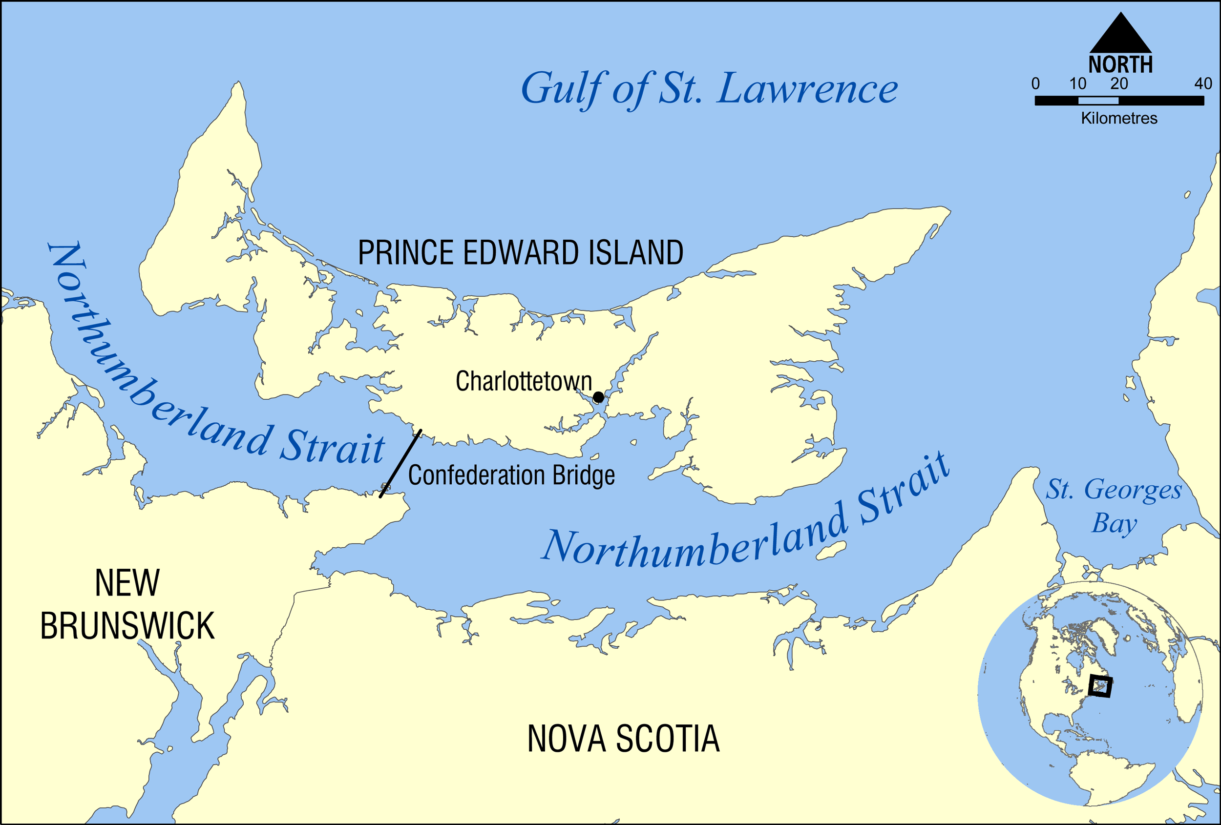
The Northumberland Strait (French: ''détroit de Northumberland'') is a strait in the southern part of the Gulf of Saint Lawrence in eastern Canada. The strait is formed by Prince Edward Island and the gulf's eastern, southern, and western shores. Boundaries The western boundary of the strait is delineated by a line running between North Cape, Prince Edward Island and Point Escuminac, New Brunswick while the eastern boundary is delineated by a line running between East Point, Prince Edward Island and Inverness, Nova Scotia. Hydrography The Northumberland Strait varies in depth between 17 and 65 metres, with the deepest waters at either end. The tidal patterns are complex; the eastern end has the usual two tides per day, with a tidal range of 1.2 to 1.8 metres, while the western end effectively has only one tide per day. The strait's shallow depths lend to warm water temperatures in summer months, with some areas reaching 25° C, or 77° F. Consequently, the strait is rep ... [...More Info...] [...Related Items...] OR: [Wikipedia] [Google] [Baidu] |
2023 Establishments In New Brunswick
3 (three) is a number, numeral and digit. It is the natural number following 2 and preceding 4, and is the smallest odd prime number and the only prime preceding a square number. It has religious or cultural significance in many societies. Evolution of the Arabic digit The use of three lines to denote the number 3 occurred in many writing systems, including some (like Roman and Chinese numerals) that are still in use. That was also the original representation of 3 in the Brahmic (Indian) numerical notation, its earliest forms aligned vertically. However, during the Gupta Empire the sign was modified by the addition of a curve on each line. The Nāgarī script rotated the lines clockwise, so they appeared horizontally, and ended each line with a short downward stroke on the right. In cursive script, the three strokes were eventually connected to form a glyph resembling a with an additional stroke at the bottom: ३. The Indian digits spread to the Caliphate in the 9th ... [...More Info...] [...Related Items...] OR: [Wikipedia] [Google] [Baidu] |
List Of Municipalities In New Brunswick
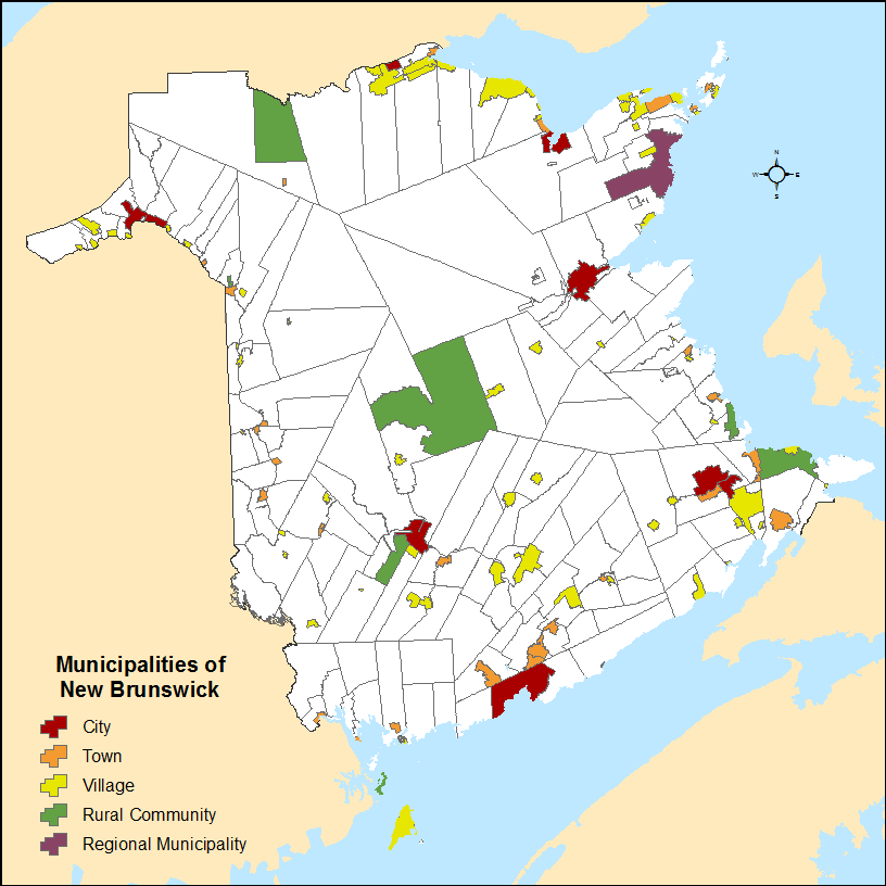
New Brunswick is the eighth-most populous province in Canada, with 775,610 residents as of the 2021 census, and the third-smallest province by land area, at . New Brunswick's 104 municipalities cover only of the province's land mass but are home to of its population. Municipalities in New Brunswick may be incorporated under the Municipalities Act of 1973 as a city, town, village, regional municipality, or rural community. Municipal governments are led by elected councils and are responsible for the delivery of services such as civic administration, land use planning, emergency measures, policing, road, and garbage collection. New Brunswick has 8 cities, 26 towns, 61 villages, 1 regional municipality, and 8 rural communities. Although rural communities are under the Municipalities Act, the provincial government distinguishes them from municipalities. In 1785, Saint John became the first community in what would eventually become Canada to be incorporated as a city. Moncto ... [...More Info...] [...Related Items...] OR: [Wikipedia] [Google] [Baidu] |
List Of Communities In New Brunswick
This is a list of communities in New Brunswick, a province in Canada. For the purposes of this list, a community is defined as either an incorporated municipality, an Indian reserve, or an unincorporated community inside or outside a municipality. Cities New Brunswick has eight cities. Indian reserves First Nations Parishes New Brunswick has 152 parishes, of which 150 are recognized as census subdivisions by Statistics Canada. Local service districts Rural communities New Brunswick has seven rural communities. Towns and villages New Brunswick has 27 towns and 66 villages. Neighbourhoods Local service districts Other communities and settlements This is a list of communities and settlements in New Brunswick. A–B ; A * Aboujagne * Acadie * Acadie Siding * Acadieville * Adams Gulch * Adamsville * Albert Mines * Albrights Corner * Alderwood * Aldouane * Allainville * Allardville * Allison * Ammon * Anagance * ... [...More Info...] [...Related Items...] OR: [Wikipedia] [Google] [Baidu] |
Beaubassin East
Beaubassin East is a Canadian rural community in Westmorland County, New Brunswick. The French form of the name is Beaubassin-Est. History Incorporation The rural community was incorporated on May 8, 1995 from the Local Service Districts of Boudreau West, Grand Barachois, Haute-Aboujagane, and Saint-André & LeBlanc Office, and portions of the parishes of Botsford, Sackville, and Shediac. It completely surrounds the village of Cap-Pelé. Beaubassin East is divided into six wards, numbered counterclockwise from its eastern boundary. # Ward 1 includes Bas-Cap-Pelé, Petit-Cap, Portage, and Shemogue # Ward 2 includes Saint-André-LeBlanc # Ward 3 includes Grand-Barachois # Ward 4 includes Boudreau-Ouest # Ward 5 includes Haute-Aboujagane # Ward 6 includes Cormier-Village In 2006, Trois-Ruisseaux became part of Beaubassin East. [...More Info...] [...Related Items...] OR: [Wikipedia] [Google] [Baidu] |
Francophone
French became an international language in the Middle Ages, when the power of the Kingdom of France made it the second international language, alongside Latin. This status continued to grow into the 18th century, by which time French was the language of European diplomacy and international relations. According to the 2022 report of the Organisation internationale de la Francophonie (OIF), 409 million people speak French. The OIF states that despite a decline in the number of learners of French in Europe, the overall number of speakers is rising, largely because of its presence in African countries: of the 212 million who use French daily, 54.7% are living in Africa. The OIF figures have been contested as being inflated due to the methodology used and its overly broad definition of the word francophone. According to the authors of a 2017 book on the world distribution of the French language, a credible estimate of the number of "francophones réels" (real francophones), tha ... [...More Info...] [...Related Items...] OR: [Wikipedia] [Google] [Baidu] |
Moncton
Moncton (; ) is the most populous city in the Canadian province of New Brunswick. Situated in the Petitcodiac River Valley, Moncton lies at the geographic centre of the Maritime Provinces. The city has earned the nickname "Hub City" because of its central inland location in the region and its history as a railway and land transportation hub for the Maritimes. As of the 2021 Census, the city had a population of 79,470, a metropolitan population of 157,717 and a land area of . Although the Moncton area was first settled in 1733, Moncton was officially founded in 1766 with the arrival of Pennsylvania German immigrants from Philadelphia. Initially an agricultural settlement, Moncton was not incorporated until 1855. It was named for Lt. Col. Robert Monckton, the British officer who had captured nearby Fort Beauséjour a century earlier. A significant wooden shipbuilding industry had developed in the community by the mid-1840s, allowing for the civic incorporation in 1855. But the s ... [...More Info...] [...Related Items...] OR: [Wikipedia] [Google] [Baidu] |
Provinces And Territories Of Canada
Within the geographical areas of Canada, the ten provinces and three territories are sub-national administrative divisions under the jurisdiction of the Canadian Constitution. In the 1867 Canadian Confederation, three provinces of British North America—New Brunswick, Nova Scotia, and the Province of Canada (which upon Confederation was divided into Ontario and Quebec)—united to form a federation, becoming a fully independent country over the next century. Over its history, Canada's international borders have changed several times as it has added territories and provinces, making it the world's second-largest country by area. The major difference between a Canadian province and a territory is that provinces receive their power and authority from the ''Constitution Act, 1867'' (formerly called the '' British North America Act, 1867''), whereas territorial governments are creatures of statute with powers delegated to them by the Parliament of Canada. The powers flowing from ... [...More Info...] [...Related Items...] OR: [Wikipedia] [Google] [Baidu] |
New Brunswick
New Brunswick (french: Nouveau-Brunswick, , locally ) is one of the thirteen provinces and territories of Canada. It is one of the three Maritime provinces and one of the four Atlantic provinces. It is the only province with both English and French as its official languages. New Brunswick is bordered by Quebec to the north, Nova Scotia to the east, the Gulf of Saint Lawrence to the northeast, the Bay of Fundy to the southeast, and the U.S. state of Maine to the west. New Brunswick is about 83% forested and its northern half is occupied by the Appalachians. The province's climate is continental with snowy winters and temperate summers. New Brunswick has a surface area of and 775,610 inhabitants (2021 census). Atypically for Canada, only about half of the population lives in urban areas. New Brunswick's largest cities are Moncton and Saint John, while its capital is Fredericton. In 1969, New Brunswick passed the Official Languages Act which began recognizing French as ... [...More Info...] [...Related Items...] OR: [Wikipedia] [Google] [Baidu] |
Town
A town is a human settlement. Towns are generally larger than villages and smaller than cities, though the criteria to distinguish between them vary considerably in different parts of the world. Origin and use The word "town" shares an origin with the German word , the Dutch word , and the Old Norse . The original Proto-Germanic word, *''tūnan'', is thought to be an early borrowing from Proto-Celtic *''dūnom'' (cf. Old Irish , Welsh ). The original sense of the word in both Germanic and Celtic was that of a fortress or an enclosure. Cognates of ''town'' in many modern Germanic languages designate a fence or a hedge. In English and Dutch, the meaning of the word took on the sense of the space which these fences enclosed, and through which a track must run. In England, a town was a small community that could not afford or was not allowed to build walls or other larger fortifications, and built a palisade or stockade instead. In the Netherlands, this space was a garden, ... [...More Info...] [...Related Items...] OR: [Wikipedia] [Google] [Baidu] |


.jpg)