|
Canton Of La Côte Vermeille
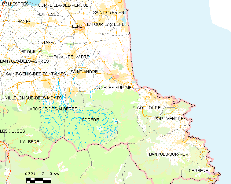
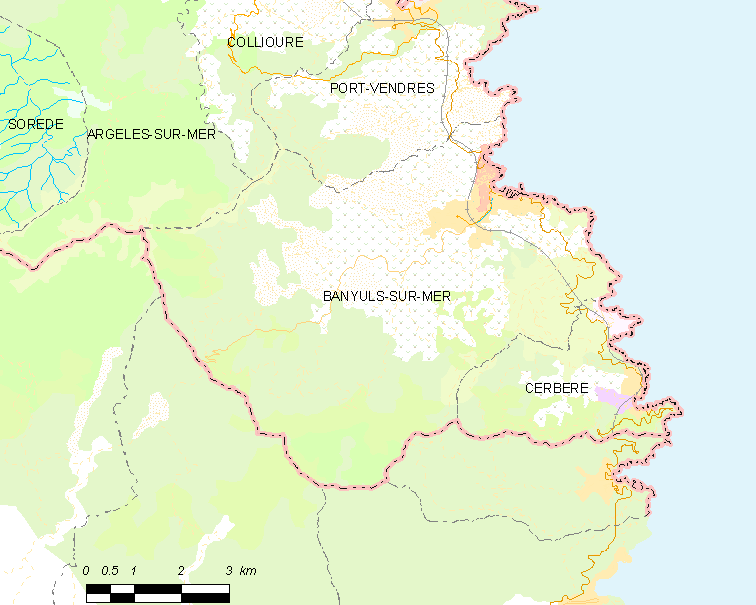
The canton of La Côte Vermeille is a canton of France, in the Pyrénées-Orientales department. Its chief town is Argelès-sur-Mer (before 2015: Port-Vendres). Composition At the French canton reorganisation which came into effect in March 2015, the canton was expanded from 4 to 7 communes: *Argelès-sur-Mer *Banyuls-sur-Mer *Cerbère *Collioure *Palau-del-Vidre *Port-Vendres * Saint-André See also * Cantons of the Pyrénées-Orientales department * Communes of the Pyrénées-Orientales department The Pyrénées-Orientales department is composed of 226 communes. Most of the territory (except for the district of Fenolheda) formed part of the Principality of Catalonia until 1659, and Catalan is still spoken (in addition to French) by a ... References Cote vermeille {{PyrénéesOrientales-geo-stub ... [...More Info...] [...Related Items...] OR: [Wikipedia] [Google] [Baidu] |
Argelès-sur-Mer
Argelès-sur-Mer (, literally ''Argelès on Sea''; ca, Argelers de la Marenda or ; oc, Argelers de Mar), commonly known as Argelès, is a commune in the Pyrénées-Orientales department in the administrative region of Occitania, France. It is about 25 km from Perpignan. Geography Argelès-sur-Mer is located in the canton of La Côte Vermeille and in the arrondissement of Céret. Argelès-sur-Mer is on the Côte Vermeille at the foot of the Albères mountain range, close to the Spanish border. It has the longest beach in the Pyrenées Orientales. History During World War II, Argelès-sur-Mer was the location of a concentration camp, where up to 100,000 defeated Spanish Republicans were interned next to a windy beach in abysmal sanitary conditions by the French government after the defeat of the Spanish Republic. The refugees streamed to the camp from the winter of 1938/39 after the collapse of the Catalan front following the rebel offensive. Government and politics ... [...More Info...] [...Related Items...] OR: [Wikipedia] [Google] [Baidu] |
Cantons Of France
The cantons of France are territorial subdivisions of the France, French Republic's Departments of France, departments and Arrondissements of France, arrondissements. Apart from their role as organizational units in relation to certain aspects of the administration of public services and justice, the chief purpose of the cantons today is to serve as Constituency, constituencies for the election of members of the representative assemblies established in each of France's territorial departments (Departmental council (France), departmental councils, formerly general councils). For this reason, such elections were known in France as "cantonal elections", until 2015 when their name was changed to "departmental elections" to match the departmental councils' name. As of 2015, there were 2,054 cantons in France. Most of them group together a number of Communes of France, communes (the lowest administrative division of the French Republic), although larger communes may be included in mo ... [...More Info...] [...Related Items...] OR: [Wikipedia] [Google] [Baidu] |
France
France (), officially the French Republic ( ), is a country primarily located in Western Europe. It also comprises of Overseas France, overseas regions and territories in the Americas and the Atlantic Ocean, Atlantic, Pacific Ocean, Pacific and Indian Oceans. Its Metropolitan France, metropolitan area extends from the Rhine to the Atlantic Ocean and from the Mediterranean Sea to the English Channel and the North Sea; overseas territories include French Guiana in South America, Saint Pierre and Miquelon in the North Atlantic, the French West Indies, and many islands in Oceania and the Indian Ocean. Due to its several coastal territories, France has the largest exclusive economic zone in the world. France borders Belgium, Luxembourg, Germany, Switzerland, Monaco, Italy, Andorra, and Spain in continental Europe, as well as the Kingdom of the Netherlands, Netherlands, Suriname, and Brazil in the Americas via its overseas territories in French Guiana and Saint Martin (island), ... [...More Info...] [...Related Items...] OR: [Wikipedia] [Google] [Baidu] |
Pyrénées-Orientales
Pyrénées-Orientales (; ca, Pirineus Orientals ; oc, Pirenèus Orientals ; ), also known as Northern Catalonia, is a department of the region of Occitania, Southern France, adjacent to the northern Spanish frontier and the Mediterranean Sea. It also surrounds the tiny Spanish exclave of Llívia, and thus has two distinct borders with Spain. In 2019, it had a population of 479,979.Populations légales 2019: 66 Pyrénées-Orientales INSEE Some parts of the Pyrénées-Orientales (like the ) are part of the . It is na ... [...More Info...] [...Related Items...] OR: [Wikipedia] [Google] [Baidu] |
Departments Of France
In the administrative divisions of France, the department (french: département, ) is one of the three levels of government under the national level ("territorial collectivities"), between the administrative regions and the communes. Ninety-six departments are in metropolitan France, and five are overseas departments, which are also classified as overseas regions. Departments are further subdivided into 332 arrondissements, and these are divided into cantons. The last two levels of government have no autonomy; they are the basis of local organisation of police, fire departments and, sometimes, administration of elections. Each department is administered by an elected body called a departmental council ( ing. lur.. From 1800 to April 2015, these were called general councils ( ing. lur.. Each council has a president. Their main areas of responsibility include the management of a number of social and welfare allowances, of junior high school () buildings and technical staff, ... [...More Info...] [...Related Items...] OR: [Wikipedia] [Google] [Baidu] |
Port-Vendres
Port-Vendres (; ca, Portvendres) is a commune in the Pyrénées-Orientales department, southwestern France. A typical Mediterranean fishing port, situated near the Spanish border on the Côte Vermeille in southwestern France, Port-Vendres is renowned for its numerous fish and sea food restaurants. Geography Port-Vendres is located in the canton of La Côte Vermeille and in the arrondissement of Céret. Port-Vendres is one of the few deep-water ports in this part of the French Mediterranean coast. It takes freighters and cruise ships, as well as large and small fishing boats which may be seen arriving with their daily catch. The geomorphology of Port-Vendres meant that it developed in a different way from the nearby port of Collioure. Whereas Collioure has two beaches which slowly descend into a relatively shallow sandy-bottomed harbour, Port-Vendres is deeper and rockier. Collioure and Port-Vendres have therefore been used for different purposes - Collioure for small com ... [...More Info...] [...Related Items...] OR: [Wikipedia] [Google] [Baidu] |
Communes Of France
The () is a level of administrative division in the French Republic. French are analogous to civil townships and incorporated municipalities in the United States and Canada, ' in Germany, ' in Italy, or ' in Spain. The United Kingdom's equivalent are civil parishes, although some areas, particularly urban areas, are unparished. are based on historical geographic communities or villages and are vested with significant powers to manage the populations and land of the geographic area covered. The are the fourth-level administrative divisions of France. vary widely in size and area, from large sprawling cities with millions of inhabitants like Paris, to small hamlets with only a handful of inhabitants. typically are based on pre-existing villages and facilitate local governance. All have names, but not all named geographic areas or groups of people residing together are ( or ), the difference residing in the lack of administrative powers. Except for the municipal arrondi ... [...More Info...] [...Related Items...] OR: [Wikipedia] [Google] [Baidu] |
Banyuls-sur-Mer
Banyuls-sur-Mer (; ) is a commune in the Pyrénées-Orientales department in southern France. It was first settled by Greeks starting in 400 BCE. Geography Location Banyuls-sur-Mer is located in the canton of La Côte Vermeille and in the arrondissement of Céret. Banyuls-sur-Mer is neighbored by Cerbère, Port-Vendres, Argelès-sur-Mer and Collioure on its French borders, and by Espolla, Rabós, Colera and Portbou on its Spanish borders. The foothills of Pyrenees, the ''Monts Albères'', run into the Mediterranean Sea in Banyuls-sur-Mer, creating a steep cliff line. Toponymy Banyuls-sur-Mer was first mentioned in 981 as ''Balneum'' or ''Balneola''. In 1074, the town started being called ''Bannils de Maritimo'' in order to distinguish it from Banyuls-dels-Aspres, which lies away. In 1197, the town was mentioned as ''Banullis de Maredine'' and in 1674. In Catalan, it has been called ''Banyuls de la Marenda'' since the 19th century. The name Banyuls indicates the presence ... [...More Info...] [...Related Items...] OR: [Wikipedia] [Google] [Baidu] |
Cerbère
Cerbère (; ca, Cervera de la Marenda) is a commune and railway town in the Pyrénées-Orientales department in southern France.Commune de Cerbère (66048) INSEE Its inhabitants are called ''Cerbériens'' (''Cerverins'' / ''Cerverines'' in Catalan). The village is best known for the border railway station, , on the French side of the on the railway line between Perpignan and |
Collioure
Collioure (; ca, Cotlliure, ) is a commune in the southern French department of Pyrénées-Orientales. Geography The town of Collioure is on the Côte Vermeille (Vermilion Coast), in the canton of La Côte Vermeille and in the arrondissement of Céret. Toponymy Collioure is named ''Cotlliure'' in Catalan. History There is a record of the castle at "Castrum Caucoliberi" having been mentioned as early as 673, indicating that the settlement here was of strategic and commercial importance during the Visigoth ascendancy. Collioure used to be divided into two villages separated by the river Douy, the old town to the south named ''Port d'Avall'' (in French known as ''Le Faubourg'') and the upstream port, ''Port d'Amunt'' (in French known as ''Le Mouré''). Collioure was taken in 1642 by the French troops of Maréchal de la Meilleraye. A decade later, the town was officially surrendered to France by the 1659 Treaty of Pyrenees. Because of its highly strategic importance, the t ... [...More Info...] [...Related Items...] OR: [Wikipedia] [Google] [Baidu] |
Palau-del-Vidre
Palau-del-Vidre (; ca, Palau del Vidre) is a commune in the Pyrénées-Orientales department in southern France. Geography Palau-del-Vidre is located in the canton of La Côte Vermeille and in the arrondissement of Céret. Population See also *Communes of the Pyrénées-Orientales department The Pyrénées-Orientales department is composed of 226 communes. Most of the territory (except for the district of Fenolheda) formed part of the Principality of Catalonia until 1659, and Catalan is still spoken (in addition to French) by a ... References Communes of Pyrénées-Orientales {{PyrénéesOrientales-geo-stub ... [...More Info...] [...Related Items...] OR: [Wikipedia] [Google] [Baidu] |
Saint-André, Pyrénées-Orientales
Saint-André (; ca, Sant Andreu de Sureda) is a Communes of France, commune in the Pyrénées-Orientales Departments of France, department in southern France. Geography Saint-André is in the canton of La Côte Vermeille and in the arrondissement of Céret. Population See also *Communes of the Pyrénées-Orientales department References Communes of Pyrénées-Orientales {{PyrénéesOrientales-geo-stub ... [...More Info...] [...Related Items...] OR: [Wikipedia] [Google] [Baidu] |


