|
Canton Of Elne
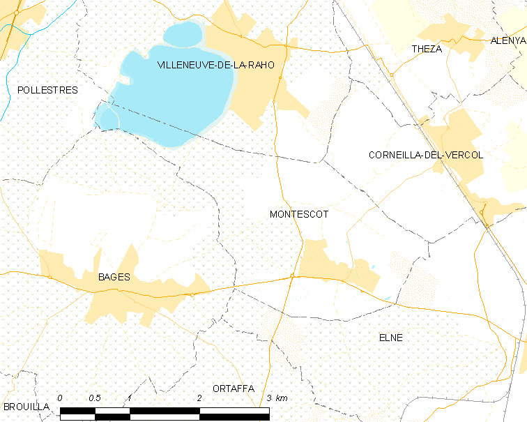
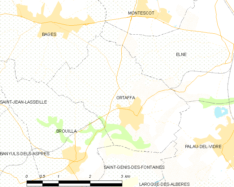
The Canton of Elne is a former French canton of Pyrénées-Orientales department, in Languedoc-Roussillon. Ministère de l'Intérieur It had 22,823 inhabitants (2012).Populations légales 2012: 66 Pyrénées-Orientales INSEE It was disbanded in 2015. Com ...
|
France
France (), officially the French Republic ( ), is a country primarily located in Western Europe. It also comprises of overseas regions and territories in the Americas and the Atlantic, Pacific and Indian Oceans. Its metropolitan area extends from the Rhine to the Atlantic Ocean and from the Mediterranean Sea to the English Channel and the North Sea; overseas territories include French Guiana in South America, Saint Pierre and Miquelon in the North Atlantic, the French West Indies, and many islands in Oceania and the Indian Ocean. Due to its several coastal territories, France has the largest exclusive economic zone in the world. France borders Belgium, Luxembourg, Germany, Switzerland, Monaco, Italy, Andorra, and Spain in continental Europe, as well as the Netherlands, Suriname, and Brazil in the Americas via its overseas territories in French Guiana and Saint Martin. Its eighteen integral regions (five of which are overseas) span a combined area of ... [...More Info...] [...Related Items...] OR: [Wikipedia] [Google] [Baidu] |
Cantons Of France
The cantons of France are territorial subdivisions of the French Republic's departments and arrondissements. Apart from their role as organizational units in relation to certain aspects of the administration of public services and justice, the chief purpose of the cantons today is to serve as constituencies for the election of members of the representative assemblies established in each of France's territorial departments ( departmental councils, formerly general councils). For this reason, such elections were known in France as "cantonal elections", until 2015 when their name was changed to "departmental elections" to match the departmental councils' name. As of 2015, there were 2,054 cantons in France. Most of them group together a number of communes (the lowest administrative division of the French Republic), although larger communes may be included in more than one canton, since the cantons – in marked contrast to the communes, which have between more than two million i ... [...More Info...] [...Related Items...] OR: [Wikipedia] [Google] [Baidu] |
Pyrénées-Orientales
Pyrénées-Orientales (; ca, Pirineus Orientals ; oc, Pirenèus Orientals ; ), also known as Northern Catalonia, is a department of the region of Occitania, Southern France, adjacent to the northern Spanish frontier and the Mediterranean Sea. It also surrounds the tiny Spanish exclave of Llívia, and thus has two distinct borders with Spain. In 2019, it had a population of 479,979.Populations légales 2019: 66 Pyrénées-Orientales INSEE Some parts of the Pyrénées-Orientales (like the Cerdagne) are part of the . It is named after the [...More Info...] [...Related Items...] OR: [Wikipedia] [Google] [Baidu] |
Languedoc-Roussillon
Languedoc-Roussillon (; oc, Lengadòc-Rosselhon ; ca, Llenguadoc-Rosselló) is a former administrative region of France. On 1 January 2016, it joined with the region of Midi-Pyrénées to become Occitania. It comprised five departments, and bordered the other French regions of Provence-Alpes-Côte d'Azur, Rhône-Alpes, Auvergne, Midi-Pyrénées towards the north, and Spain, Andorra and the Mediterranean Sea towards the south. It was the southernmost region of mainland France. Toponymy The first part of the name of the province of Languedoc-Roussillon comes from the French ("language of "), and is also a historical region. In southern France, the word for ''yes'' was the Occitan language word . Prior to the 16th century, the central area of France was referred to as , there the word for ''yes'' was in Old French, later becoming . These old place names referred to the areas where Occitan and Old French were spoken. The Edict of Villers-Cotterets made French the official nati ... [...More Info...] [...Related Items...] OR: [Wikipedia] [Google] [Baidu] |
Institut National De La Statistique Et Des études économiques
The National Institute of Statistics and Economic Studies (french: link=no, Institut national de la statistique et des études économiques), abbreviated INSEE or Insee ( , ), is the national statistics bureau of France. It collects and publishes information about the French economy and people and carries out the periodic national census. Headquartered in Montrouge, a commune in the southern Parisian suburbs, it is the French branch of Eurostat. The INSEE was created in 1946 as a successor to the Vichy regime's National Statistics Service (SNS). It works in close cooperation with the Institut national d'études démographiques (INED). Purpose The INSEE is responsible for the production and analysis of official statistics in France. Its best known responsibilities include: * Organising and publishing the national census. * Producing various indices – which are widely recognised as being of excellent quality – including an inflation index used for determining the rate ... [...More Info...] [...Related Items...] OR: [Wikipedia] [Google] [Baidu] |
Communes Of France
The () is a level of administrative division in the French Republic. French are analogous to civil townships and incorporated municipalities in the United States and Canada, ' in Germany, ' in Italy, or ' in Spain. The United Kingdom's equivalent are civil parishes, although some areas, particularly urban areas, are unparished. are based on historical geographic communities or villages and are vested with significant powers to manage the populations and land of the geographic area covered. The are the fourth-level administrative divisions of France. vary widely in size and area, from large sprawling cities with millions of inhabitants like Paris, to small hamlets with only a handful of inhabitants. typically are based on pre-existing villages and facilitate local governance. All have names, but not all named geographic areas or groups of people residing together are ( or ), the difference residing in the lack of administrative powers. Except for the municipal arr ... [...More Info...] [...Related Items...] OR: [Wikipedia] [Google] [Baidu] |
Elne
Elne (; ca, Elna ) is a commune in the Pyrénées-Orientales department in southern France. It lies in the former province of Roussillon, of which it was the first capital, being later replaced by Perpignan. Its inhabitants are still called ''Illibériens'' in reference to the city's Iberian name, Illiberis, one that it shared with the Illiberis that became Granada, Spain. Geography Elne is located in the canton of La Plaine d'Illibéris and in the arrondissement of Perpignan. It is situated from the Mediterranean near the Tech River, in Pyrénées-Orientales, from Perpignan and from Argelès. History Elne, from the heights of its fortified site, dominates the narrow plain of Roussillon between the Pyrenees and the Mediterranean. Numerous archeological researches have shown that the surrounding countryside has been occupied since Neolithic times. Elne was an Iberian ''oppidum'' or fortified town. Elne is the oldest town in Roussillon and since it is situated on the ... [...More Info...] [...Related Items...] OR: [Wikipedia] [Google] [Baidu] |
Bages, Pyrénées-Orientales
Bages (; ca, Bages de Rosselló) is a commune in the Pyrénées-Orientales department in southern France. Geography Localisation Bages is located in the canton of La Plaine d'Illibéris and in the arrondissement of Perpignan. Government and politics Mayors Population See also *Communes of the Pyrénées-Orientales department The Pyrénées-Orientales department is composed of 226 communes. Most of the territory (except for the district of Fenolheda) formed part of the Principality of Catalonia until 1659, and Catalan is still spoken (in addition to French) by a ... References Communes of Pyrénées-Orientales {{PyrénéesOrientales-geo-stub ... [...More Info...] [...Related Items...] OR: [Wikipedia] [Google] [Baidu] |
Corneilla-del-Vercol
Corneilla-del-Vercol (; ca, Cornellà del Bercol) is a commune in the Pyrénées-Orientales department in southern France. Geography Localisation Corneilla-del-Vercol is located in the canton of La Plaine d'Illibéris and in the arrondissement of Perpignan. Population Notable people * Pierre Jonquères d'Oriola (1920-2011), equestrian born in Corneilla-del-Vercol. See also *Communes of the Pyrénées-Orientales department The Pyrénées-Orientales department is composed of 226 communes. Most of the territory (except for the district of Fenolheda) formed part of the Principality of Catalonia until 1659, and Catalan is still spoken (in addition to French) by a ... References Communes of Pyrénées-Orientales {{PyrénéesOrientales-geo-stub ... [...More Info...] [...Related Items...] OR: [Wikipedia] [Google] [Baidu] |
Montescot
Montescot () is a commune in the Pyrénées-Orientales department in southern France. Geography Montescot is located in the canton of La Plaine d'Illibéris and in the arrondissement of Perpignan. Population See also *Communes of the Pyrénées-Orientales department * Via Domitia The Via Domitia was the first Roman road built in Gaul, to link Italy and Hispania through Gallia Narbonensis, across what is now Southern France. The route that the Romans regularised and paved was ancient when they set out to survey it, and ... References Communes of Pyrénées-Orientales {{PyrénéesOrientales-geo-stub ... [...More Info...] [...Related Items...] OR: [Wikipedia] [Google] [Baidu] |
Ortaffa
Ortaffa (; ca, Ortafà) is a commune in the Pyrénées-Orientales department in southern France. Geography Ortaffa is located in the canton of La Plaine d'Illibéris and in the arrondissement of Perpignan. Population See also *Communes of the Pyrénées-Orientales department The Pyrénées-Orientales department is composed of 226 communes. Most of the territory (except for the district of Fenolheda) formed part of the Principality of Catalonia until 1659, and Catalan is still spoken (in addition to French) by a ... References Communes of Pyrénées-Orientales {{PyrénéesOrientales-geo-stub ... [...More Info...] [...Related Items...] OR: [Wikipedia] [Google] [Baidu] |


