|
Canada Temperance Act
The ''Canada Temperance Act'' (french: Loi de tempérance du Canada), also known as the ''Scott Act'', was an Act of the Parliament of Canada passed in 1878, which provided for a national framework for municipalities to opt in by plebiscite to a scheme of prohibition. It was repealed in 1984. Pre-Confederation colonial legislation Temperance legislation of general application had been enacted by the various colonies as early as 1855, when New Brunswick implemented total prohibition to mixed success. Others, beginning with the Province of Canada on the passage of the ''Dunkin Act'' in 1864, named after its sponsor Christopher Dunkin, opted to allow local municipalities to implement temperance upon an approval by plebiscite. The Act proved to be problematic in its operation following the division of the Province into Ontario and Quebec. In ''Ex parte O'Neill'', RJQ 24 SC 304, it was held that the Legislative Assembly of Quebec could not repeal the ''Dunkin Act'', but it could pass a ... [...More Info...] [...Related Items...] OR: [Wikipedia] [Google] [Baidu] |
Parliament Of Canada
The Parliament of Canada (french: Parlement du Canada) is the federal legislature of Canada, seated at Parliament Hill in Ottawa, and is composed of three parts: the King, the Senate, and the House of Commons. By constitutional convention, the House of Commons is dominant, with the Senate rarely opposing its will. The Senate reviews legislation from a less partisan standpoint and may initiate certain bills. The monarch or his representative, normally the governor general, provides royal assent to make bills into law. The governor general, on behalf of the monarch, summons and appoints the 105 senators on the advice of the prime minister, while each of the 338 members of the House of Commons – called members of Parliament (MPs) – represents an electoral district, commonly referred to as a ''riding'', and are elected by Canadian voters residing in the riding. The governor general also summons and calls together the House of Commons, and may prorogue or dissolve Parliament, ... [...More Info...] [...Related Items...] OR: [Wikipedia] [Google] [Baidu] |
Carleton County, New Brunswick
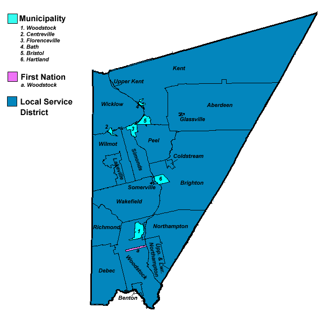
Carleton County (2016 population 26,220) is located in west-central New Brunswick, Canada. The western border is Aroostook County, Maine, Aroostook County, Maine, the northern border is Victoria County, New Brunswick, Victoria County, and the southeastern border is York County, New Brunswick, York County from which it was formed in 1831. The Saint John River (New Brunswick), Saint John River bisects the western section of the county. The Southwest Miramichi River flows through the eastern section of the county. Potato farming is a major industry. The scenic town of Hartland, New Brunswick, Hartland is home to the longest covered bridge in the world. Transportation Major Highways * * * * * * * * * * * * * * * * * * * * Census subdivisions List of communities in New Brunswick, Communities There are five incorporated municipalities within Carleton County (listed by 2016 population): First Nations There is one First Nations reserve in Carleton County, the Woodstock_First_Na ... [...More Info...] [...Related Items...] OR: [Wikipedia] [Google] [Baidu] |
Huron County, Ontario
Huron County is a county of the province of Ontario, Canada. It is located on the southeast shore of its namesake, Lake Huron, in the southwest part of the province. The county seat is Goderich, also the county's largest community. The population reported in the 2021 Census for this predominantly agricultural area with many villages and small towns was 61,366 in a land area of 3,399 square kilometres. Of the total population, 7,628 reside in Goderich. History File:HuronTract.JPG, Original extent of the Huron Tract. File:1850 Tallis Map of West Canada or Ontario ( includes Great Lakes ) - Geographicus - WestCanada-tallis-1850.jpg, Map of Canada West in 1850, with the Huron District outlined in brown. File:1857 Colton Map of Ontario, Canada - Geographicus - CanadaWest-colton-1857.jpg, Canada West in 1857. Huron County is marked in light pink. The portion of the Huron Tract ceded to the Canada Company was established as the "County of Huron" in 1835, with the exception of ce ... [...More Info...] [...Related Items...] OR: [Wikipedia] [Google] [Baidu] |
District Of Manitoulin
Manitoulin District is a district in Northeastern Ontario within the Canadian province of Ontario. It was created in 1888 from part of the Algoma District. The district seat is in Gore Bay. It comprises Manitoulin Island primarily, as well as a number of smaller islands surrounding it, such as Barrie, Cockburn, and Great La Cloche islands. Previously it included the municipality of Killarney on the mainland, until this was transferred to Sudbury District in the late 1990s. Subsequently, more mainland portions were added to Killarney and these, together with Unorganized Mainland Manitoulin District, were also transferred to Sudbury District in 2006, about in all. Geography The district has an area of , making it the smallest district in Ontario. It is in the northern part of Lake Huron, separated from the mainland by the North Channel to the north and by the Georgian Bay to the east. Islands included within the district are: * Barrie Island * Bedford Island * Burnt Islands (Bi ... [...More Info...] [...Related Items...] OR: [Wikipedia] [Google] [Baidu] |
Thetford Mines
Thetford Mines ( Canada 2021 Census population 26,072) is a city in south-central Quebec, Canada. It is the seat of Les Appalaches Regional County Municipality. The city is located in the Appalachian Mountains, 141 miles northeast of Montreal and 107 km south of Quebec City.Thetford Mines thecanadianencyclopedia.ca It is known mostly as the asbestos capital of Canada. History  Before
|
Guysborough, Nova Scotia
Guysborough, officially named the Municipality of the District of Guysborough, is a district municipality in Guysborough County, Nova Scotia, Canada. Statistics Canada classifies the district municipality as a municipal district. It is home to the Boylston and Salsman Provincial Parks. The parks are located between Boylston and Guysborough. History The area was originally called Chedabouctou and was the site of one of a fishing post of Nicolas Denys. In 1682, a permanent settlement was started by Clerbaud Bergier. A group cleared land and spent the winter with the first crops being planted in 1683. Louis-Alexandre des Friches de Meneval landed at Chedabouctou in 1687 when arriving to take up his position as governor of Acadia. The community is named after Sir Guy Carleton. Geography Occupying the eastern half of Guysborough County, the district municipality's administrative centre is the community of Guysborough. The district completely surrounds the Town of Mulgrave and it ... [...More Info...] [...Related Items...] OR: [Wikipedia] [Google] [Baidu] |
Yarmouth, Nova Scotia
Yarmouth is a town in southwestern Nova Scotia, Canada. A port town, industries include fishing, and tourism. It is the terminus of a ferry service to Bar Harbor, Maine, run by Bay Ferries. History Originally inhabited by the Mi'kmaq, the region was known as "Keespongwitk" meaning "Lands End" due to its position at the tip of the Nova Scotia peninsula. European settlement The region was visited in 1604 by Samuel de Champlain, who named it "Cap-Fourchu", meaning "forked or cloven cape." The first Europeans to make a settlement on these shores were the French Acadians. They set up a small fishing settlement known as "Tebouque" in the mid 1600s and by 1750 the population was 50 people. During the Seven Years' War, New England Planters settled at what is now the town of Yarmouth in 1759; the grantees were from Yarmouth, Massachusetts and they requested that Yarmouth be named after their former home. Yarmouth was founded on June 9, 1761, when a ship carrying three families arrived fr ... [...More Info...] [...Related Items...] OR: [Wikipedia] [Google] [Baidu] |
Digby, Nova Scotia
Digby is an incorporated town in southwestern Nova Scotia, Canada. It is in the historical Digby County, Nova Scotia, county of Digby and a separate municipality from the Municipality of the District of Digby. The town is situated on the western shore of the Annapolis Basin near the entrance to the Digby Gut, which connects the basin to the Bay of Fundy. Named after Robert Digby (Royal Navy officer), Admiral Robert Digby, the town has a scallop fishing fleet. The MV Fundy Rose, MV ''Fundy Rose'' ferry service connects the town to Saint John, New Brunswick. History Digby is called Oositookun, meaning ear of land, by the Mi'kmaq. A small group of New England Planters settled in the area of the town in the 1760s naming it Conway. However Digby was formally settled and surveyed as a town in June 1783 by the United Empire Loyalists under the leadership of Sir Robert Digby (admiral), Robert Digby. The town developed a sizable shipping fleet in the 19th century. One famous Digby vessel ... [...More Info...] [...Related Items...] OR: [Wikipedia] [Google] [Baidu] |
Lisgar (electoral District)
Lisgar was a federal electoral district in Manitoba, Canada, that was represented in the House of Commons of Canada from 1871 to 1988. This riding was created following the admission of Manitoba into the Canadian Confederation in 1870. It was abolished in 1987 when it was redistributed into Brandon—Souris, Lisgar—Marquette and Provencher ridings. Election results By-election: As a result of Manitoba joining Confederation, 15 July 1870 By-election: On Mr. Richardson's election being declared void, 20 July 1901 By-election: On Mr. Muir's death, 26 August 1970 See also * List of Canadian federal electoral districts * Past Canadian electoral districts This is a list of past arrangements of Canada's electoral districts. Each district sends one member to the House of Co ... [...More Info...] [...Related Items...] OR: [Wikipedia] [Google] [Baidu] |
Marquette (electoral District)
Marquette was a federal electoral district in Manitoba, Canada, that was represented in the House of Commons of Canada from 1871 to 1979. This riding was created in 1871 following the creation of the province of Manitoba in 1870. It was abolished in 1976 when it was redistributed into Brandon—Souris, Dauphin and Portage—Marquette ridings. Election results By-election: As a result of Manitoba joining Confederation, 15 July 1870 ''double member constituency in 1871'' By-election: During trial of election petition, 25 August 1874 Ryan was declared the sitting member, as a result of the scrutiny of votes. By-election: On Mr. Macdonald being appointed Prime Minister of Canada, 16 October 1878. Macdonald chose to run in another riding in his ministerial by-election. By-election: On Mr. Watson's resignation By-election: On Mr. Roche being appointed Secretary of State for Canada, 10 October 1911 ... [...More Info...] [...Related Items...] OR: [Wikipedia] [Google] [Baidu] |
Westmorland County, New Brunswick
Westmorland County (2016 population: 149,623) is a county in New Brunswick, a province of Canada. It is in the south-eastern part of the province. It contains the fast-growing commercial centre of Moncton and its northern and eastern suburbs. Also located in the county are the university town of Sackville and the tourist destination of Shediac. Westmorland County is centrally located in the Maritimes and is New Brunswick's most populous county. Fishing and tourism are important industries along the Northumberland Strait shore, and there is some mixed farming in the Petitcodiac River Valley and in the Tantramar Marsh region. The city of Moncton accounts for half of the county's population and has developed as a major transportation, distribution, commercial and retail centre. Dorchester is the historic shire town. Origins The county, once a part of Cumberland County, Nova Scotia, was one of the original eight counties delineated shortly after the creation of the British col ... [...More Info...] [...Related Items...] OR: [Wikipedia] [Google] [Baidu] |
Northumberland County, New Brunswick
Northumberland County is located in northeastern New Brunswick, Canada. Geography Northumberland County is covered by thick forests, whose products stimulate the economy. The highest peaks in the province, including Mount Carleton lie in the northwestern corner of the county. The county is dominated by the Miramichi River, world famous for its salmon fishing. The lower portion of the river is an estuary that widens into Miramichi Bay, a part of the Gulf of St. Lawrence. Services The city of Miramichi is a local service centre for the county and surrounding regions with schools, hospitals and government offices and retail locations. The county has several saw mills in the city of Miramichi and up the Southwest Branch of the Miramichi River. There were formerly two large pulp and paper mills at Miramichi. Chatham was also home to an air force base, CFB Chatham, until 1996. Renous-Quarryville, located along the Southwest Miramichi was also home to an army post - a federal ... [...More Info...] [...Related Items...] OR: [Wikipedia] [Google] [Baidu] |
.jpg)


