|
Cameroon–Nigeria Border
The Cameroon–Nigeria border is 1,975 km (1,227 mi) in length and runs from the tripoint with Chad in the north to the Atlantic Ocean in the south. Description The border starts in the north at the tripoint with Chad in Lake Chad, proceeding through the lake via a NW-SE straight line down to the estuary of the Ebedi river. The border follows this river as it flows to the south-east, before turning south, proceeding overland in this direction via a series of irregular lines and some small rivers (such as the Kalia). In the vicinity of the parallel 11°30 the border turns to the south-west, turning north-west at the town of Banki, and then south-west through the Mandara Mountains and Atlantika Mountains, occasionally utilising rivers such as the Mayo Tiel and Benue. At about the parallel of 6°30 the border shifts to the west, using irregular lines and rivers such as the Donga, before continuing in a south-west direction via various overland lines and rivers (such as the Cros ... [...More Info...] [...Related Items...] OR: [Wikipedia] [Google] [Baidu] |
Calabar
Calabar (also referred to as Callabar, Calabari, Calbari and Kalabar) is the capital city of Cross River State, Nigeria. It was originally named Akwa Akpa, in the Efik language. The city is adjacent to the Calabar and Great Kwa rivers and creeks of the Cross River (from its inland delta). Calabar is often described as the tourism capital of Nigeria, especially due to several initiatives implemented during the administration of Donald Duke as governor of Cross River State (1999–2007), which made the city the cleanest and most environmentally friendly city in Nigeria. Administratively, the city is divided into Calabar Municipal and Calabar South Local Government Areas. It has an area of and a population of 371,022 as at 2006 census. History Calabar was the name given by the Portuguese discoverers from the 15th century to the tribes on this part of the Guinea coast at the time of their arrival, when the present inhabitants in the district were the Quas. It was not till th ... [...More Info...] [...Related Items...] OR: [Wikipedia] [Google] [Baidu] |
Order In Council
An Order-in-Council is a type of legislation in many countries, especially the Commonwealth realms. In the United Kingdom this legislation is formally made in the name of the monarch by and with the advice and consent of the Privy Council ('' King-in-Council''), but in other countries the terminology may vary. The term should not be confused with Order of Council, which is made in the name of the Council without royal assent. Types, usage and terminology Two principal types of Order in Council exist: Orders in Council whereby the King-in-Council exercises the royal prerogative, and Orders in Council made in accordance with an Act of Parliament. In the United Kingdom, orders are formally made in the name of the monarch by the Privy Council ('' King-in-Council or Queen-in-Council''). In Canada, federal Orders in Council are made in the name of the Governor General by the King's Privy Council for Canada; provincial Orders-in-Council are of the Lieutenant-Governor-in-Council by the ... [...More Info...] [...Related Items...] OR: [Wikipedia] [Google] [Baidu] |
Southern Cameroons
The Southern Cameroons was the southern part of the British Empire, British League of Nations mandate territory of the British Cameroons in West Africa. Since 1961, it has been part of the Republic of Cameroon, where it makes up the Northwest Region (Cameroon), Northwest Region and Southwest Region (Cameroon), Southwest Region. Since 1994, pressure groups in the territory claim there was no legal document (treaty of union) in accordance to UNGA RES 1608(XV) paragraph 5, and are seeking to restore statehood and independence from the Republic. They renamed the British Southern Cameroons as Ambazonia (from Ambas Bay). League of Nations mandate Following the Treaty of Versailles, the German territory of Kamerun was divided on June 28, 1919, between a French and a British League of Nations Mandate, the French, who had previously administered the whole occupied territory, getting the larger. The French mandate was known as Cameroun. The British mandate comprised two adjacent territorie ... [...More Info...] [...Related Items...] OR: [Wikipedia] [Google] [Baidu] |
Northern Cameroons
British Cameroon or the British Cameroons was a British mandate territory in British West Africa, formed of the Northern Cameroons and Southern Cameroons. Today, the Northern Cameroons forms parts of the Borno, Adamawa and Taraba states of Nigeria, while the Southern Cameroons forms part of the Northwest and Southwest regions of Cameroon. History The area of present-day Cameroon was claimed by Germany as a protectorate during the "Scramble for Africa" at the end of the 19th century. The German Empire named the territory Kamerun. During World War I, French and British troops invaded the German colony Kamerun (Present day Cameroon) and decided to divide the German colony into two regions. One of the regions would be French administered (French Cameroon) and the other would be British administered (British Cameroon). The British were more concerned with other areas of Africa, specifically Nigeria. Thus, the French gained a larger portion of Cameroon when the country was divide ... [...More Info...] [...Related Items...] OR: [Wikipedia] [Google] [Baidu] |
League Of Nations
The League of Nations (french: link=no, Société des Nations ) was the first worldwide intergovernmental organisation whose principal mission was to maintain world peace. It was founded on 10 January 1920 by the Paris Peace Conference that ended the First World War. The main organization ceased operations on 20 April 1946 but many of its components were relocated into the new United Nations. The League's primary goals were stated in its Covenant. They included preventing wars through collective security and disarmament and settling international disputes through negotiation and arbitration. Its other concerns included labour conditions, just treatment of native inhabitants, human and drug trafficking, the arms trade, global health, prisoners of war, and protection of minorities in Europe. The Covenant of the League of Nations was signed on 28 June 1919 as Part I of the Treaty of Versailles, and it became effective together with the rest of the Treaty on 10 January 1920. T ... [...More Info...] [...Related Items...] OR: [Wikipedia] [Google] [Baidu] |
First World War
World War I (28 July 1914 11 November 1918), often abbreviated as WWI, was one of the deadliest global conflicts in history. Belligerents included much of Europe, the Russian Empire, the United States, and the Ottoman Empire, with fighting occurring throughout Europe, the Middle East, Africa, the Pacific, and parts of Asia. An estimated 9 million soldiers were killed in combat, plus another 23 million wounded, while 5 million civilians died as a result of military action, hunger, and disease. Millions more died in genocides within the Ottoman Empire and in the 1918 influenza pandemic, which was exacerbated by the movement of combatants during the war. Prior to 1914, the European great powers were divided between the Triple Entente (comprising France, Russia, and Britain) and the Triple Alliance (containing Germany, Austria-Hungary, and Italy). Tensions in the Balkans came to a head on 28 June 1914, following the assassination of Archduke Franz Ferdina ... [...More Info...] [...Related Items...] OR: [Wikipedia] [Google] [Baidu] |
Yola, Adamawa
Yola (Fulfulde: Ƴoola), meaning 'Great Plain' or 'Vast Plain Land', is the largest city, capital city and administrative center of Adamawa State, Nigeria. Located on the Benue River, it has a population of 336,648 (2010). Yola is splited into two parts. The old town of Yola where the Lamido resides is the traditional city but the new city of Jimeta (about 5 km NW) is the administrative and commercial centre. Generally the term Yola is now used to mean both. To the north are the Mandara Mountains and to the south are the Shebshi Mountains which Mount Dimlang (Vogel Peak) is part of. Yola is an access point to the Gashaka Gumpti Nature Reserve, which is the largest national park in Nigeria, the Ngel Nyaki montane forest reserve, the Mambilla Plateau, the Sukur UNESCO World heritage site, which is Africa's first cultural landscape to receive World Heritage List inscription, the Yadin Waterfalls, the Kiri Dam on the Gongola River, the Benue national park in nearby Cameroon ... [...More Info...] [...Related Items...] OR: [Wikipedia] [Google] [Baidu] |
Rio Del Rey
The Rio del Rey (also called Rio del Ray) is an estuary of a drainage basin in West Africa in Cameroon. It is located in the eastern area of the Niger River system.African Basins pp. 173-176 The Cameroon volcanic line separates Rio Del Rey from the Douala basin. Rio del Rey has been described as an estuary in which "the two rivers N'dian and Massake flow out". pp. 127-133. The mouth is close to the |
Cameroon Boundary Changes
Cameroon (; french: Cameroun, ff, Kamerun), officially the Republic of Cameroon (french: République du Cameroun, links=no), is a country in west-central Africa. It is bordered by Nigeria to the west and north; Chad to the northeast; the Central African Republic to the east; and Equatorial Guinea, Gabon and the Republic of the Congo to the south. Its coastline lies on the Bight of Biafra, part of the Gulf of Guinea and the Atlantic Ocean. Due to its strategic position at the crossroads between West Africa and Central Africa, it has been categorized as being in both camps. Its nearly 27 million people speak 250 native languages. Early inhabitants of the territory included the Sao civilisation around Lake Chad, and the Baka hunter-gatherers in the southeastern rainforest. Portuguese explorers reached the coast in the 15th century and named the area ''Rio dos Camarões'' (''Shrimp River''), which became ''Cameroon'' in English. Fulani soldiers founded the Adamawa Emirate in ... [...More Info...] [...Related Items...] OR: [Wikipedia] [Google] [Baidu] |
Berlin Conference
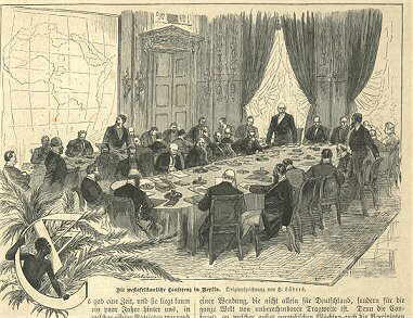
The Berlin Conference of 1884–1885, also known as the Congo Conference (, ) or West Africa Conference (, ), regulated European colonisation and trade in Africa during the New Imperialism period and coincided with Germany's sudden emergence as an imperial power. The conference was organized by Otto von Bismarck, the first chancellor of Germany. Its outcome, the General Act of the Berlin Conference, can be seen as the formalisation of the Scramble for Africa, but some historians warn against an overemphasis of its role in the colonial partitioning of Africa, and draw attention to bilateral agreements concluded before and after the conference. The conference contributed to ushering in a period of heightened colonial activity by European powers, which eliminated or overrode most existing forms of African autonomy and self-governance. Of the fourteen countries being represented, six of them – Austria-Hungary, Russia, Denmark, the Netherlands, Sweden–Norway, and the Unite ... [...More Info...] [...Related Items...] OR: [Wikipedia] [Google] [Baidu] |


