|
Calabasas Peak
Calabasas Peak is a mountain located in the Santa Monica Mountains in the city of Calabasas, California. The summit is accessible via the Calabasas Peak Motorway, a wide trail maintained by the Santa Monica Mountains Conservancy. The Calabasas Peak Motorway is accessible from Old Topanga Canyon Road and Stunt Road trailheads, as well as an informal path on a trailhead on Mulholland Highway. The peak is the highest point in a wide ascent that runs parallel to Mulholland Highway, which is a part of the larger Santa Monica Mountains. The mountain is vegetated by dwarf forest shrubbery and chaparral plants around the mountainside and ascending trail, but is composed of large rock formations and sand at the peak. Certain wildlife and animals are a common sight around the mountain range, including deer, rattlesnakes, and coyotes. The mountain and trail was partially burned during the 2016 Old Fires in Calabasas, and again during the 2018 Woolsey Fire. After these fires, the mountainside ... [...More Info...] [...Related Items...] OR: [Wikipedia] [Google] [Baidu] |
Santa Monica Mountains
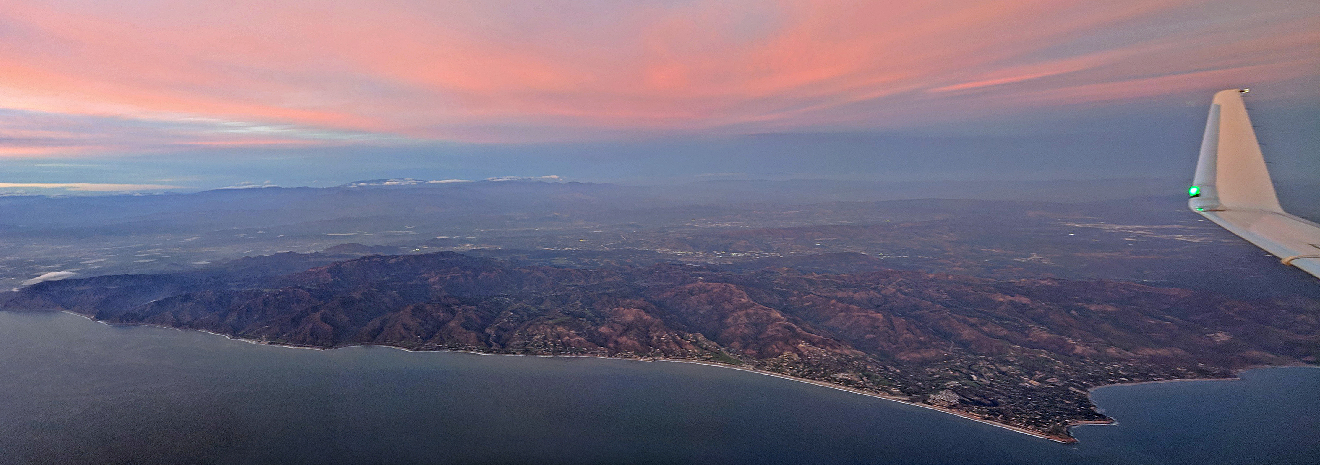
The Santa Monica Mountains is a coastal mountain range in Southern California, next to the Pacific Ocean. It is part of the Transverse Ranges. Because of its proximity to densely populated regions, it is one of the most visited natural areas in California. The Santa Monica Mountains National Recreation Area encompasses this mountain range. Geography The range extends approximately east-west from the Hollywood Hills in Los Angeles to Point Mugu in Ventura County. The western mountains, separating the Conejo Valley from Malibu, suddenly end at Mugu Peak as the rugged, nearly impassible shoreline gives way to tidal lagoons and coastal sand dunes of the alluvial Oxnard Plain. The mountain range contributed to the isolation of this vast coastal plain before regular transportation routes reached western Ventura County. The eastern mountains form a barrier between the San Fernando Valley and the Los Angeles Basin, separating "the Valley" on the north and west-central Los Angeles ... [...More Info...] [...Related Items...] OR: [Wikipedia] [Google] [Baidu] |
Calabasas, California
Calabasas (from Spanish language, Spanish ''calabazas'' "gourds") is a city in the southwestern region of the San Fernando Valley, between the foothills of the Santa Monica Mountains, Santa Monica and Santa Susana Mountains, Santa Susanna mountains.City of Calabasas Official website The city was municipal corporation, incorporated in 1991, prior to which it was an unincorporated portion of Los Angeles County, California, Los Angeles County. As of the 2020 United States Census, 2020 census, the city's population was 23,241, up from 23,058 at the 2010 United States Census, 2010 census. Naming The name ''Calabasas'' is derived from the Spanish language, Spanish , meaning "pumpkin", "squash (plant), squash", or "gour ...[...More Info...] [...Related Items...] OR: [Wikipedia] [Google] [Baidu] |
Mulholland Highway
Mulholland Highway is a scenic road in Los Angeles County, California, that runs approximately 50 miles through the western Santa Monica Mountains from near US Route 101 (Ventura Freeway) in Calabasas to Highway 1 (Pacific Coast Highway) near Malibu at Leo Carrillo State Park and the Pacific Ocean coast – at the border of Los Angeles and Ventura Counties. Mulholland Highway is the western rural portion and with the eastern Mulholland Drive portion, is a scenic route named after Los Angeles civil engineer William Mulholland and built throughout the 1920s "to take Angelenos from the city to the ocean". Only the segment of Mulholland Highway between Pacific Coast Highway and Kanan Dume Road, and through Malibu Creek State Park between Cornell Road and Las Virgenes Road, is officially recognized by the California Department of Transportation as under the California Scenic Highway System, meaning that it is a substantial section of highway passing through a "memorable landsc ... [...More Info...] [...Related Items...] OR: [Wikipedia] [Google] [Baidu] |
Dwarf Forest
Dwarf forest, elfin forest, or pygmy forest is an uncommon ecosystem featuring miniature trees, inhabited by small species of fauna such as rodents and lizards. They are usually located at high elevations, under conditions of sufficient air humidity but poor soil. There are two main dwarf forest ecosystem types, involving different species and environmental characteristics: coastal temperate and montane tropical regions. Temperate coastal dwarf forest is common for parts of Southern California. Montane tropical forests are found across tropical highlands of Central America, northern South America and Southeast Asia. There are also other isolated examples of dwarf forests scattered across the world, while the largest dwarf forest is found in the Philippines. High-elevation tropical dwarf forest High-elevation tropical locations in cloud forests contain mossy wet elfin forests due to high-elevation precipitation. These regions are characterized by low rainfall, with most of the wa ... [...More Info...] [...Related Items...] OR: [Wikipedia] [Google] [Baidu] |
Chaparral
Chaparral ( ) is a shrubland plant community and geographical feature found primarily in the U.S. state of California, in southern Oregon, and in the northern portion of the Baja California Peninsula in Mexico. It is shaped by a Mediterranean climate (mild wet winters and hot dry summers) and infrequent, high-intensity crown fires. Chaparral features summer-drought-tolerant plants with hard sclerophyllous evergreen leaves, as contrasted with the associated soft-leaved, drought-deciduous, scrub community of coastal sage scrub, found often on drier, southern facing slopes within the chaparral biome. Three other closely related chaparral shrubland systems occur in central Arizona, western Texas, and along the eastern side of central Mexico's mountain chains (mexical), all having summer rains in contrast to the Mediterranean climate of other chaparral formations. Chaparral comprises 9% of California's wildland vegetation and contains 20% of its plant species. The name comes from th ... [...More Info...] [...Related Items...] OR: [Wikipedia] [Google] [Baidu] |
Woolsey Fire
The Woolsey Fire was a wildfire that burned in Los Angeles and Ventura Counties of the U.S. state of California. The fire ignited on November 8, 2018, and burned of land. The fire destroyed 1,643 structures, killed three people, and prompted the evacuation of more than 295,000 people. It was one of several fires in California that ignited on the same day. While the nearby Hill Fire was contained with minimal damage on November 16, the Camp Fire in Northern California destroyed most of the town of Paradise, killing 85 people. The fire started in Woolsey Canyon on the Santa Susana Field Laboratory property, and burned 80% of the site, a complex of industrial research and development buildings belonging to Boeing, in the Santa Susana Mountains above the Simi Valley near the boundary between Los Angeles and Ventura counties. The Santa Ana winds, which often are a factor for Southern California fires, pushed the fire in a southerly direction throughout the first day. The Ventura free ... [...More Info...] [...Related Items...] OR: [Wikipedia] [Google] [Baidu] |
List Of Mountains Of The United States
This list includes significant mountain peaks and high points located in the United States arranged alphabetically by state, district, or territory. The highest peak or point in each state, district or territory is noted in bold. Significant mountain peaks and high points Alabama *Brindley Mountain * Cheaha Mountain, highest summit in the State of Alabama *Monte Sano Mountain * Capshaw Mountain * Dirtseller Mountain * Frog Mountain *Hawk Pride Mountain * Gunters Mountain *Sand Mountain (Alabama) * Keel Mountain (Alabama) *Halama Mountain Alaska * Afognak Mountain, summit of Afognak Island * Amak Volcano, active stratovolcano * Amherst Peak * Amulet Peak * Andy Simons Mountain * Annex Peak * Anvil Peak , active stratovolcano that forms the summit of Semisopochnoi Island * Arthur Peak * Asses Ears (Alaska) * Atna Peaks * Atuk Mountain , summit of St. Lawrence Island * Augustine Volcano, active lava dome that forms the summit of Augustine Island * Auke Mo ... [...More Info...] [...Related Items...] OR: [Wikipedia] [Google] [Baidu] |
Santa Monica Mountains
The Santa Monica Mountains is a coastal mountain range in Southern California, next to the Pacific Ocean. It is part of the Transverse Ranges. Because of its proximity to densely populated regions, it is one of the most visited natural areas in California. The Santa Monica Mountains National Recreation Area encompasses this mountain range. Geography The range extends approximately east-west from the Hollywood Hills in Los Angeles to Point Mugu in Ventura County. The western mountains, separating the Conejo Valley from Malibu, suddenly end at Mugu Peak as the rugged, nearly impassible shoreline gives way to tidal lagoons and coastal sand dunes of the alluvial Oxnard Plain. The mountain range contributed to the isolation of this vast coastal plain before regular transportation routes reached western Ventura County. The eastern mountains form a barrier between the San Fernando Valley and the Los Angeles Basin, separating "the Valley" on the north and west-central Los Angeles ... [...More Info...] [...Related Items...] OR: [Wikipedia] [Google] [Baidu] |


