|
Babinda
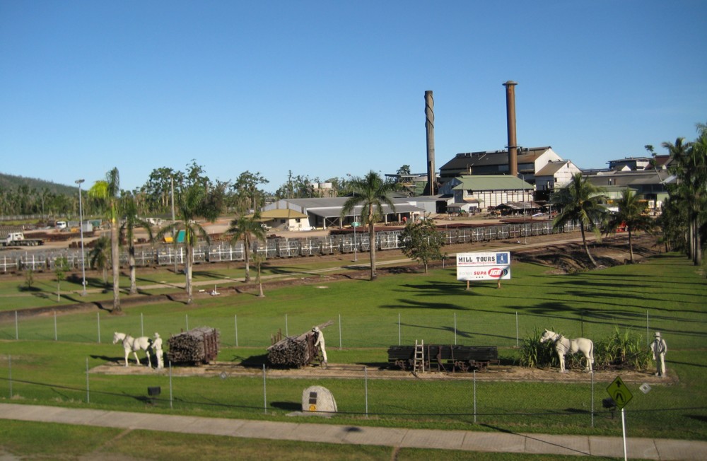
Babinda is a rural town and locality in the Cairns Region, Queensland, Australia. In the , the locality of Babinda had a population of 1,253 people. Geography Babinda is located south of Cairns. The town is noted for its proximity to Queensland's two highest mountains Mount Bartle Frere (Queensland's highest peak) and Mount Bellenden Ker. Babinda and Tully annually compete for the Golden Gumboot, an award for Australia's wettest town. Babinda is usually the winner, recording an annual average rainfall of over each year. History Babinda takes its name from the local Indigenous Australian language for ''mountain''. Other sources, however, claim it is a Yidinji word for ''water'', possibly referring to the high rainfall of the area. Babinda State School opened on 4 November 1914. Babinda Post Office opened by 1915 (a ''Babinda Creek'' receiving office had been open since 1891). The Babinda Sugar Mill opened on 15 September 1915. It closed on 23 February 2011. Babinda Pres ... [...More Info...] [...Related Items...] OR: [Wikipedia] [Google] [Baidu] |
Mirriwinni, Queensland
Mirriwinni is a rural town and locality in the Cairns Region, Queensland, Australia. The spelling ''Miriwinni'' has also been used historically, but ''Mirriwinni'' is the official spelling from 8 October 2010. In the , the locality of Mirriwinni had a population of 447 people. Geography The town is south of the centre of the locality. The Russell River forms the eastern and south-eastern boundary, while Babinda Creek forms part of the northern boundary. The foothills of Mount Bartle Frere form the western boundary. Most of the land in the locality is flat low-lying land (approx 10 metres above sea level) and is used for farming, predominantly growing sugarcane. However, in the western edge of the locality, the land rises to up to 150 metres above sea level heading towards the peaks of Mount Bartle Frere in the adjacent locality of Wooroonooran. The Bruce Highway and the North Coast railway line traverse the locality from south to west, both passing through the town. There ... [...More Info...] [...Related Items...] OR: [Wikipedia] [Google] [Baidu] |
Bellenden Ker, Queensland
Bellenden Ker is a rural town and locality in the Cairns Region, Queensland, Australia. In the , the locality of Bellenden Ker had a population of 252 people. History Bellenden Ker State School opened on 14 August 1922. Bellenden Ker Post Office opened on 1 July 1936 and closed on 23 November 1974. In the , Bellenden Ker had a population of 475 people. In the , the locality of Bellenden Ker had a population of 252 people. Education Bellenden Ker State School is a government primary (Prep-6) school for boys and girls at Harvey Creek Road (). In 2018, the school had an enrolment of 10 students with 2 teachers (1 full-time equivalent) and 4 non-teaching staff (1 full-time equivalent). There are no secondary schools in Bellenden Ker. The nearest government secondary school is Babina State School in neighbouring Babinda to the south. Amenities There is a boat ramp with jetty on the Russell River Road on the north bank of the Russell River (). It is managed by the Cairns ... [...More Info...] [...Related Items...] OR: [Wikipedia] [Google] [Baidu] |
East Russell, Queensland
East Russell is a coastal locality in the Cairns Region, Queensland, Australia. In the , East Russell had a population of 71 people. Geography East Russell is located on the coast, east of Babinda, slightly north of Innisfail and south of Cairns. The Russell River forms the western border of East Russell. In the north Russell River meets the Mulgrave River at Mutchero Inlet which marks the northern extent of the locality. Much of the coastal area is protected within the Russell River National Park. Several peaks in the park reach elevations above 600 m. High Island, Normanby Island, Round Island, Russell Island and several offshore reefs belong to the Frankland Group National Park Frankland Group is a national park in Queensland, Australia, 1353 km northwest of Brisbane. The five continental islands of the Frankland Group are High Island, Normanby Island, Mabel Island, Round Island and Russell Island, which lie .... The eastern fringe of the locality has ... [...More Info...] [...Related Items...] OR: [Wikipedia] [Google] [Baidu] |
Tully, Queensland
Tully is a town and locality in the Cassowary Coast Region, Queensland, Australia. It is adjacent to the Bruce Highway, approximately south of Cairns by road and north of Townsville. At the , the population was 2,390. Tully is perhaps best known for being one of the wettest towns in Australia and home to the 7.9 metre tall Golden Gumboot. The Tully River (previously known as the Mackay River) was named after Surveyor-General William Alcock Tully in the 1870s. The town of Tully was named after the river when it was surveyed during the erection of the sugar mill in 1924 (although the river does not flow through the town or the locality). During the previous decade, a settlement known as Banyan had grown up on the other side of Banyan Creek. Tully is one of the larger towns of the Cassowary Coast Region. The economic base of the region is agriculture: sugar cane and bananas are the dominant crops. The sugar cane grown at the many farms in the district is processed locally at th ... [...More Info...] [...Related Items...] OR: [Wikipedia] [Google] [Baidu] |
Golden Gumboot
The Golden Gumboot is a competition between the Far North Queensland towns of Tully, Innisfail, and Babinda in Australia for the wettest town of Australia. These towns are located in the Wet Tropics and on land that was previously covered by rainforest. These areas experience some of the highest levels of rainfall in Australia through monsoonal rain and cyclones. The winner for the competition (since 1970) was awarded a rubber boot. Despite the fact that Babinda has had more rainfall than Tully in the last 40 years, The Golden Gumboot monument was erected in Tully by the Tully Lions and Rotary Clubs on 10 May 2003. The project cost, including in-kind contributions, was $90,000. The official opening took place on 10 May 2003. The boot stands at 7.9 metres (25.9 ft) and represents the record rainfall for Tully in 1950. The boot is composed of fibreglass and has a spiral staircase to the top of the boot that allows a view of the town. Historical photographs of floods i ... [...More Info...] [...Related Items...] OR: [Wikipedia] [Google] [Baidu] |
Cairns
Cairns (, ) is a city in Queensland, Australia, on the tropical north east coast of Far North Queensland. The population in June 2019 was 153,952, having grown on average 1.02% annually over the preceding five years. The city is the 5th-most-populous in Queensland, and 15th in Australia. The city was founded in 1876 and named after Sir William Wellington Cairns, following the discovery of gold in the Hodgkinson river. Throughout the late 19th century, Cairns prospered from the settlement of Chinese immigrants who helped develop the region's agriculture. Cairns also served as a port for blackbirding ships, bringing slaves and indentured labourers to the sugar plantations of Innisfail. During World War II, the city became a staging ground for the Allied Forces in the Battle of the Coral Sea. By the late 20th century the city had become a centre of international tourism, and in the early 21st century has developed into a major metropolitan city. Cairns is a popular tourist ... [...More Info...] [...Related Items...] OR: [Wikipedia] [Google] [Baidu] |
Eubenangee, Queensland
Eubenangee is a coastal locality split between the Cairns Region and the Cassowary Coast Region, Queensland, Australia. In the , the population of Eubenangee was 242 people. Geography The larger northern part of the locality () is in Cairns Region with the smaller southern part () in the Cassowary Coast Region. The western part of the locality is very low-lying undeveloped wetland (approx 10 metres above sea level) and forms part of the Eubenangee Swamp National Park. In contrast the north-eastern part of the locality is mountainous undeveloped land rising to Mount Arthur (470 metres above sea level), part of being in the Ella Bay National Park. The developed land is mostly on the fringes of the Eubenangee Swamp National Park; it is mostly used for crop farming with sugarcane predominating. Eubenangee is a watershed with the northern part of the locality draining towards the Russell River (which enters the Coral Sea between Deeral and East Russell) and the southern part ... [...More Info...] [...Related Items...] OR: [Wikipedia] [Google] [Baidu] |
Mount Bartle Frere
Mount Bartle Frere (pronunciation [ˈmæɔnt̥ ˈbɐːɾəɫ ˈfɹɪə]; Ngajanji: Choorechillum) is the highest mountain in Queensland at an elevation of . The mountain was named after Sir Henry Bartle Frere, 1st Baronet, Sir Henry Bartle Frere, a British colonial administrator and then president of the Royal Geographical Society by George Elphinstone Dalrymple in 1873. Bartle Frere was British Governor of Cape Colony at the outset of the Anglo-Zulu War. It is located south of Cairns, Queensland, Cairns in the Wooroonooran National Park southwest of the town of Babinda, Queensland, Babinda on the eastern edge of the Atherton Tablelands. Mount Bartle Frere is part of the Bellenden Ker Range and the watershed of Russell River (Queensland), Russell River. The foothill to summit is entirely covered by rainforest, ranging from typical tropical rainforest in the lowlands to low cloud forest at the cooler summit, where temperatures are up to 10 °C (18 °F) lower than on t ... [...More Info...] [...Related Items...] OR: [Wikipedia] [Google] [Baidu] |
Cairns, Queensland
Cairns (, ) is a city in Queensland, Australia, on the tropical north east coast of Far North Queensland. The population in June 2019 was 153,952, having grown on average 1.02% annually over the preceding five years. The city is the 5th-most-populous in Queensland, and 15th in Australia. The city was founded in 1876 and named after Sir William Wellington Cairns, following the discovery of gold in the Hodgkinson river. Throughout the late 19th century, Cairns prospered from the settlement of Chinese immigrants who helped develop the region's agriculture. Cairns also served as a port for blackbirding ships, bringing slaves and indentured labourers to the sugar plantations of Innisfail. During World War II, the city became a staging ground for the Allied Forces in the Battle of the Coral Sea. By the late 20th century the city had become a centre of international tourism, and in the early 21st century has developed into a major metropolitan city. Cairns is a popular tourist ... [...More Info...] [...Related Items...] OR: [Wikipedia] [Google] [Baidu] |
Cairns Region
The Cairns Region is a local government area in Far North Queensland, Queensland, Australia, centred on the regional city of Cairns. It was established in 2008 by the amalgamation of the City of Cairns and the Shires of Douglas and Mulgrave. However, following public protest and a referendum in 2013, on 1 January 2014, the Shire of Douglas was de-amalgamated from the Cairns Region and re-established as a separate local government authority. The Cairns Regional Council has an estimated operating budget of A$300 million. History First Nations '' Yidinji'' (also known as ''Yidinj'', ''Yidiny'', and ''Idindji'') is an Australian Aboriginal language and a traditional Indigenous country. Its traditional language region is within the local government areas of Cairns Region and Tablelands Region, in such localities as Cairns City (CBD), Gordonvale, and the Mulgrave River, and the southern part of the Atherton Tableland including Atherton and Kairi. '' Tjapukai'' (also known as ... [...More Info...] [...Related Items...] OR: [Wikipedia] [Google] [Baidu] |
Roman Catholic Bishop Of Cairns
The Roman Catholic Diocese of Cairns is a diocese of the Catholic Church located in the state of Queensland, Australia. It is a suffragan diocese of the Archdiocese of Brisbane. The diocese was erected as a vicariate apostolic in 1877 and was elevated to a diocese in 1941. Its territorial remit is Far North Queensland. St Monica's Cathedral is the seat of the Catholic Bishop of Cairns, currently vacant. History Following the discovery of gold near Cooktown in 1872 and the establishment and growth of sugar production during the 1870s, the Bishop of Brisbane, James Quinn, visited Cooktown in 1874. The first church was opened a year later. Quinn had earlier been petitioning the Roman Curia to create a vicariate in north Queensland to minister to Catholics in the region and to evangelise the Aborigines, with the Vicariate Apostolic of Queensland officially created on 27 January 1877 by Pope Pius IX. The Vicariate consisted of all the land in Queensland north of the line ... [...More Info...] [...Related Items...] OR: [Wikipedia] [Google] [Baidu] |
Innisfail, Queensland
Innisfail (from Irish: Inis Fáil) is a regional town and locality in the Cassowary Coast Region, Queensland, Australia. The town was originally called Geraldton until 1910. In the , the town of Innisfail had a population of 7,236 people, while the locality of Innisfail had a population of 1,145 people. Innisfail is the major township of the Cassowary Coast Region and is known for its sugar and banana industries, as well as for being one of Australia's wettest towns. In March 2006, Innisfail gained worldwide attention when severe Tropical Cyclone Larry passed over causing extensive damage. Geography Innisfail's town centre is situated at the junction of the Johnstone River and South Johnstone River, approximately from the coast. It is located near large tracts of old-growth tropical rainforest surrounded by vast areas of extensive farmlands. Queensland's highest mountain, Mount Bartle Frere; part of Australia's Great Dividing Range, is to the north. The town's central bu ... [...More Info...] [...Related Items...] OR: [Wikipedia] [Google] [Baidu] |

%2C_2018.jpg)


