|
Brunnsviken
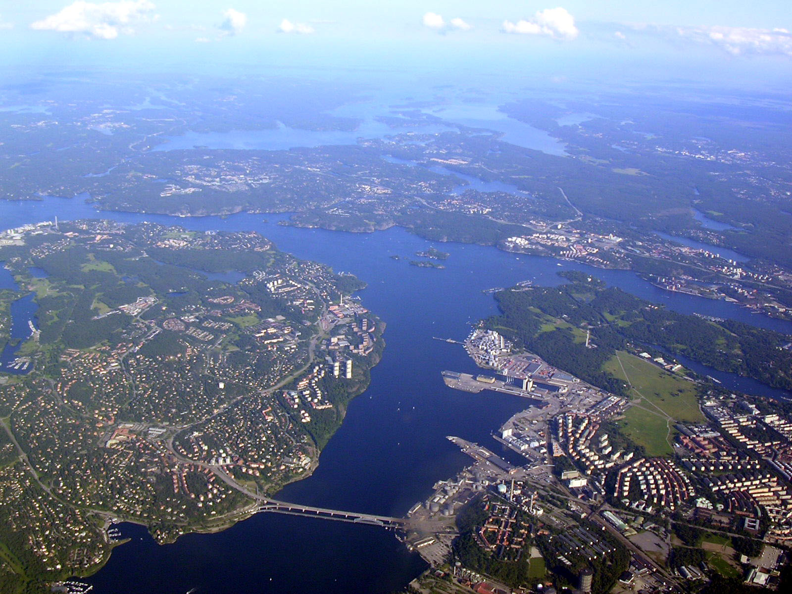
Brunnsviken (literally ''The Bay of Wells'') is a by brackish lake in Sweden located on the boundary between Solna Municipality and Stockholm Municipality, connecting to Lilla Värtan through Ålkistan. It has a perimeter of . Around Brunnsviken there are a wide range of interesting buildings and facilities. Brunnsviken stretches all the way from Vasastaden, Stockholm in the south to Bergshamra, Solna in the north, with Hagaparken along the western shoreline. In the 1700s, Gustav III had plans to build a continuous belt of English parks around the lake. Since 1994, Brunnsviken has been a part of the Royal National City Park The Royal National City Park ( sv, Kungliga nationalstadsparken) is a national city park, established by the Riksdag in 1995, and located in the municipalities of Stockholm, Solna and Lidingö in Sweden. 1/ km²2/ Population per km² Gallery .... References Lakes of Stockholm County Geography of Stockholm {{Stockholm-geo-stub ... [...More Info...] [...Related Items...] OR: [Wikipedia] [Google] [Baidu] |
Ålkistan
Ålkistan (Swedish language, Swedish: "The Eel Hatch") is the name of a canal, and the surrounding area, north of Stockholm, Sweden. The canal connects Lilla Värtan to Lake Brunnsviken, and delimits Bergshamra (Solna), Bergshamra, the northern part of Solna Municipality, Solna, from the northern part of Djurgården. The name ''Ålkistan'' first appears on a map of Djurgården dated 1649, pointing out ''Åhlekijstetorpet'' ("The Eel Hatch Cottage"), ''Åhlekijstebackan'' ("The Eel Hatch Hillside") and ''Åhlekijste wijken'' ("The Eel Hatch Bay"). In a rivulet leading to the bay eels were caught using cages (in Swedish called ''kista'', "coffin"), which gave the area its present name. The cottage is mentioned as a tavern in 1789. By the mid-19th century, mud threatened to cork the rivulet, which would effectively have turned Lake Brunnsviken, being used as refuse dump as it was, into a sewer. King Charles XV of Sweden, Charles XV therefore ordered the present canal to be construc ... [...More Info...] [...Related Items...] OR: [Wikipedia] [Google] [Baidu] |
Hagaparken
Hagaparken ("Haga Park"), or simply Haga in Solna Municipality just north of Stockholm, Sweden, is a vast and popular nature area, with large lawns, woods and gardens. Description Hagaparken is located along the western shoreline of Brunnsviken and is a part of the Royal National City Park. Within the park are Haga Palace, King Gustav III's Pavilion, the Chinese Pavilion, the Haga Echo Temple, the Turkish Kiosk, an older castle ruin (which is not really a ruin as it is the remains of a castle never finished) and several other interesting buildings on the grounds (such as the peculiar Copper Tents and also the Butterfly House). Included in the Haga Park is also the Royal Burial Ground of the Swedish Royal family (since 1922), where several members and ancestors of the present Swedish royal Bernadotte family rest. Ulriksdal Palace ( Swedish: ''Ulriksdals slott'') is a royal palace situated in Hagaparken. History The master plan for development was originally designed by archit ... [...More Info...] [...Related Items...] OR: [Wikipedia] [Google] [Baidu] |
Bergshamra, Solna
Bergshamra is a suburb within the Stockholm urban area in Sweden. Administratively it is in Solna Municipality of Stockholm County. The suburb is surrounded on three sides by water, with the Stocksundet sea strait to the north-east, the Ålkistan channel to the south-east, and the Brunnsviken to the south-west. Bergshamra station is one of the 100 stations of the Stockholm metro The Stockholm metro ( sv, Stockholms tunnelbana) is a rapid transit system in Stockholm, Sweden. The first line opened in 1950, and today the system has 100 stations in use, of which 47 are underground and 53 above ground. There are three colou ... system. Stockholm urban area Metropolitan Stockholm Suburbs in Europe Solna Municipality {{Stockholm-geo-stub ... [...More Info...] [...Related Items...] OR: [Wikipedia] [Google] [Baidu] |
Stockholm
Stockholm () is the Capital city, capital and List of urban areas in Sweden by population, largest city of Sweden as well as the List of urban areas in the Nordic countries, largest urban area in Scandinavia. Approximately 980,000 people live in the Stockholm Municipality, municipality, with 1.6 million in the Stockholm urban area, urban area, and 2.4 million in the Metropolitan Stockholm, metropolitan area. The city stretches across fourteen islands where Mälaren, Lake Mälaren flows into the Baltic Sea. Outside the city to the east, and along the coast, is the island chain of the Stockholm archipelago. The area has been settled since the Stone Age, in the 6th millennium BC, and was founded as a city in 1252 by Swedish statesman Birger Jarl. It is also the county seat of Stockholm County. For several hundred years, Stockholm was the capital of Finland as well (), which then was a part of Sweden. The population of the municipality of Stockholm is expected to reach o ... [...More Info...] [...Related Items...] OR: [Wikipedia] [Google] [Baidu] |
Sweden
Sweden, formally the Kingdom of Sweden,The United Nations Group of Experts on Geographical Names states that the country's formal name is the Kingdom of SwedenUNGEGN World Geographical Names, Sweden./ref> is a Nordic country located on the Scandinavian Peninsula in Northern Europe. It borders Norway to the west and north, Finland to the east, and is connected to Denmark in the southwest by a bridgetunnel across the Öresund. At , Sweden is the largest Nordic country, the third-largest country in the European Union, and the fifth-largest country in Europe. The capital and largest city is Stockholm. Sweden has a total population of 10.5 million, and a low population density of , with around 87% of Swedes residing in urban areas in the central and southern half of the country. Sweden has a nature dominated by forests and a large amount of lakes, including some of the largest in Europe. Many long rivers run from the Scandes range through the landscape, primarily ... [...More Info...] [...Related Items...] OR: [Wikipedia] [Google] [Baidu] |
Lake
A lake is an area filled with water, localized in a basin, surrounded by land, and distinct from any river or other outlet that serves to feed or drain the lake. Lakes lie on land and are not part of the ocean, although, like the much larger oceans, they do form part of the Earth's water cycle. Lakes are distinct from lagoons, which are generally coastal parts of the ocean. Lakes are typically larger and deeper than ponds, which also lie on land, though there are no official or scientific definitions. Lakes can be contrasted with rivers or streams, which usually flow in a channel on land. Most lakes are fed and drained by rivers and streams. Natural lakes are generally found in mountainous areas, rift zones, and areas with ongoing glaciation. Other lakes are found in endorheic basins or along the courses of mature rivers, where a river channel has widened into a basin. Some parts of the world have many lakes formed by the chaotic drainage patterns left over from the la ... [...More Info...] [...Related Items...] OR: [Wikipedia] [Google] [Baidu] |
Brackish
Brackish water, sometimes termed brack water, is water occurring in a natural environment that has more salinity than freshwater, but not as much as seawater. It may result from mixing seawater (salt water) and fresh water together, as in estuaries, or it may occur in brackish fossil aquifers. The word comes from the Middle Dutch root '' brak''. Certain human activities can produce brackish water, in particular civil engineering projects such as dikes and the flooding of coastal marshland to produce brackish water pools for freshwater prawn farming. Brackish water is also the primary waste product of the salinity gradient power process. Because brackish water is hostile to the growth of most terrestrial plant species, without appropriate management it is damaging to the environment (see article on shrimp farms). Technically, brackish water contains between 0.5 and 30 grams of salt per litre—more often expressed as 0.5 to 30 parts per thousand (‰), which is a specific grav ... [...More Info...] [...Related Items...] OR: [Wikipedia] [Google] [Baidu] |
Solna Municipality
Solna Municipality ( sv, Solna kommun or , ) is a municipality in Stockholm County in Sweden, located just north of Stockholm City Centre. Its seat is located in the town of Solna, which is a part of the Stockholm urban area. Solna is one of the richest municipalities in Sweden. The municipality is a part of Metropolitan Stockholm. None of the area is considered rural, which is unusual for Swedish municipalities, which normally are of mixed rural/urban character. Solna is the third smallest municipality in Sweden in terms of area. Solna borders Stockholm Municipality to the south, southeast and northwest; to Sundbyberg Municipality to the west; to Sollentuna Municipality to the north; and to Danderyd Municipality to the northeast. The boundary with Danderyd Municipality is delineated by the Stocksundet strait. There are two parishes in Solna Municipality: Råsunda (population 29,677) and Solna (population 28,317). Solna Parish once included parts of present-day City of Stock ... [...More Info...] [...Related Items...] OR: [Wikipedia] [Google] [Baidu] |
Stockholm Municipality
Stockholm Municipality or the City of Stockholm ( sv, Stockholms kommun or ) is a municipality in Stockholm County in east central Sweden. It has the largest population of the 290 municipalities of the country, but one of the smallest areas, making it the second most densely populated. It is also the most populous municipality in the Nordic countries. Although legally a municipality with the official proper name ''Stockholms kommun'', the municipal assembly () has decided to use the name ''Stockholms stad'' (''City of Stockholm'' in English) whenever possible. This is purely nominal and has no effect on the legal status of the municipality. Geographically, the city comprises the Stockholm City Centre and two suburban areas, Söderort (South Stockholm) and Västerort (West Stockholm). Administratively, it is subdivided into 14 districts (sometimes incorrectly called "boroughs" in English), which are administered by district councils (). Geography Geographically, the City of Sto ... [...More Info...] [...Related Items...] OR: [Wikipedia] [Google] [Baidu] |
Lilla Värtan
Lilla Värtan ( sv, Smaller Värtan) or simply Värtan is a strait in Stockholm, Sweden. Separating mainland Stockholm from the island and municipality Lidingö, it stretches from Blockhusudden in the south to Stora Värtan in the north, and is joined by the Stocksundet mid-way. Two bridges, collectively called Lidingöbron ("Lidingö Bridge") stretch over the strait. While most of the coasts surrounding the strait are occupied by industries and the ferry terminals and oil tanks in the harbour area of Värtahamnen, natural beaches are found in both the southern and the northern end of the strait and the strait forms part of the Royal National City Park. Most common fish species are Baltic herring, sea trout, and salmon. Stationary predator fishes, e.g. northern pike and perch, are exposed to raised levels of mercury. The area is considered an important wintering location for several birds species, including swans, Eurasian coot, common pochard, tufted duck, black-headed gull, ... [...More Info...] [...Related Items...] OR: [Wikipedia] [Google] [Baidu] |
Vasastaden, Stockholm
Vasastaden, or colloquially Vasastan, (Swedish for "Vasa town") is a 3.00 km2 large city district in central Stockholm, Sweden, being a part of Norrmalm borough. The major parks in Vasastaden are Vasaparken and Observatorielunden near the centre and Vanadislunden and Bellevueparken in the north. History Vasastaden proper The city district, most likely named after the street Vasagatan, in its turn named after King Gustav Vasa in 1885, was still a peripheral part of the city in the early 1880s. Before the end of that decade, however, some 150 buildings had been built and only the properties along Odengatan remained vacant. The expansion was preceded by a city plan established in 1879, a slightly more modest edition of the 1866 intentions of city planner Albert Lindhagen, in its turn largely a continuation north of an original 17th-century plan. Like the Baroque plan, the new plan took little or no account of local topographic variations, and where the two fail ... [...More Info...] [...Related Items...] OR: [Wikipedia] [Google] [Baidu] |
Gustav III Of Sweden
Gustav III (29 March 1792), also called ''Gustavus III'', was King of Sweden from 1771 until his assassination in 1792. He was the eldest son of Adolf Frederick of Sweden and Queen Louisa Ulrika of Prussia. Gustav was a vocal opponent of what he saw as the abuse of political privileges seized by the nobility since the death of King Charles XII. Seizing power from the government in a coup d'état, called the Swedish Revolution, in 1772 that ended the Age of Liberty, he initiated a campaign to restore a measure of Royal autocracy, which was completed by the Union and Security Act of 1789, which swept away most of the powers exercised by the Swedish Riksdag (parliament) during the Age of Liberty, but at the same time it opened up the government for all citizens, thereby breaking the privileges of the nobility. A bulwark of enlightened absolutism, Gustav spent considerable public funds on cultural ventures, which were controversial among his critics, as well as military attemp ... [...More Info...] [...Related Items...] OR: [Wikipedia] [Google] [Baidu] |


