|
Brandon Rural District
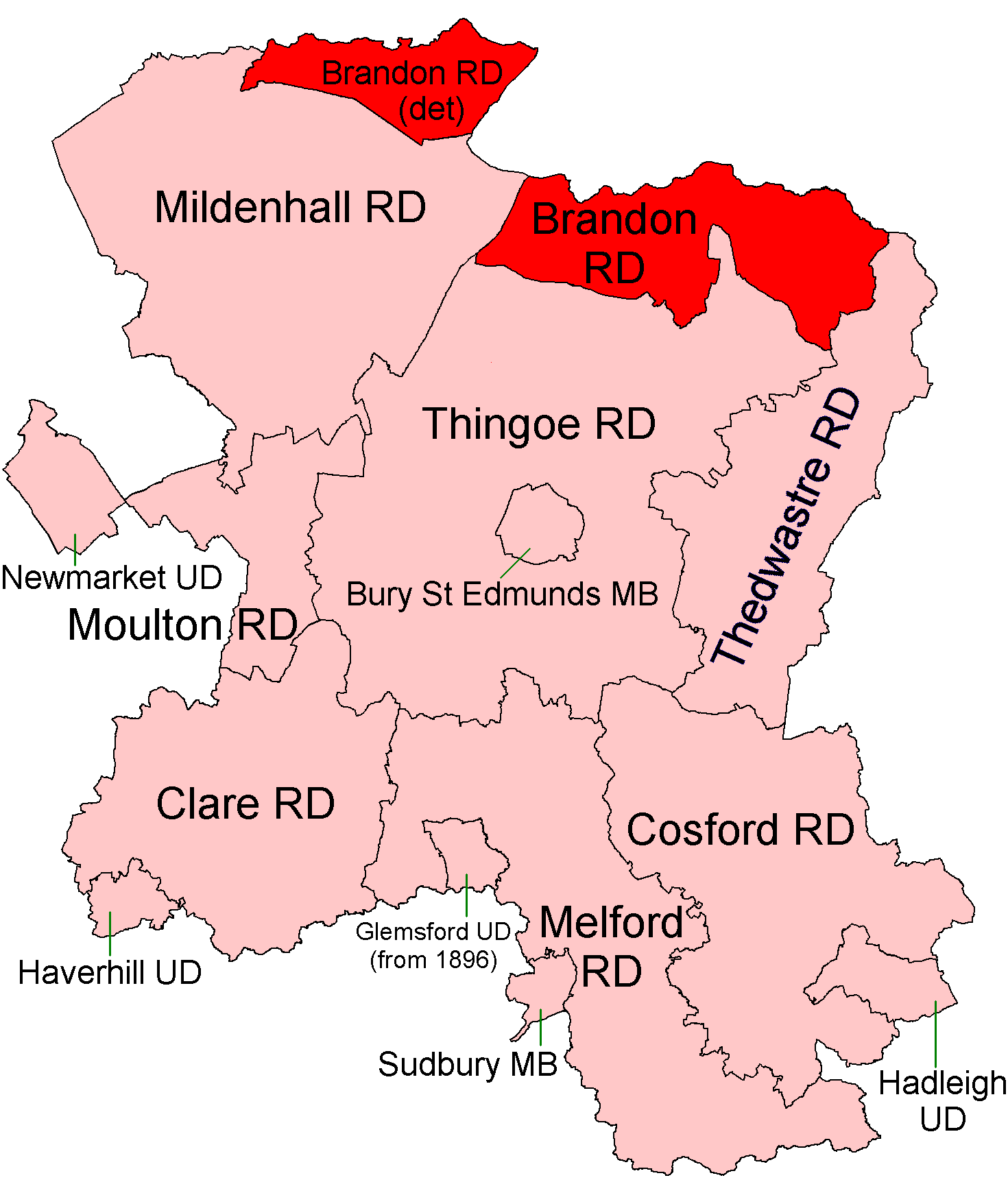
Brandon was a rural district in Suffolk, England from 1894 to 1935. The district was created in 1894 as the Suffolk part of the Thetford rural sanitary district, the Norfolk part becoming Thetford Rural District. This left the westernmost parishes of Brandon and Santon Downham detached from the rest of the district. It was abolished in 1935 and the main section of the district (the parishes of Barnham, Barningham, Coney Weston, Euston, Fakenham Magna, Hepworth, Honington, Hopton, Knettishall, Market Weston, Sapiston and Thelnetham) became part of Thingoe Rural District, which in 1974 became part of the modern Borough of St Edmundsbury. The two western parishes became part of Mildenhall Rural District in 1935, and are now in neighbouring Forest Heath district and then from 1st April 2019 onwards West Suffolk West Suffolk may refer to the following places in Suffolk, England: * West Suffolk (county), a county until 1974 * West Suffolk District, a local government distri ... [...More Info...] [...Related Items...] OR: [Wikipedia] [Google] [Baidu] |
Rural District
Rural districts were a type of local government area – now superseded – established at the end of the 19th century in England, Wales, and Ireland for the administration of predominantly rural areas at a level lower than that of the Administrative county, administrative counties.__TOC__ England and Wales In England and Wales they were created in 1894 (by the Local Government Act 1894) along with Urban district (Great Britain and Ireland), urban districts. They replaced the earlier system of sanitary districts (themselves based on poor law unions, but not replacing them). Rural districts had elected rural district councils (RDCs), which inherited the functions of the earlier sanitary districts, but also had wider authority over matters such as local planning, council house, council housing, and playgrounds and cemeteries. Matters such as education and major roads were the responsibility of county councils. Until 1930 the rural district councillors were also poor law gu ... [...More Info...] [...Related Items...] OR: [Wikipedia] [Google] [Baidu] |
Fakenham Magna
Fakenham Magna (or Great Fakenham) is a village and civil parish in the West Suffolk district of Suffolk in eastern England. The meaning of the word '''Fakenham''' can be split into two: 'Faken' and 'ham', both of which derive from Old English. The former refers to somebody by the name of 'Facca', with the latter meaning 'a village / a homestead', making the direct translation 'Facca's homestead'. '''Magna''' translates from Latin as 'great', hence the alternative name of the village of 'Great Fakenham'. During World War Two, however, the village was referred to as 'Little Fakenham', which was used to avoid confusion with the larger civil parish of Fakenham in Norfolk. Located on the A1088 road around eight miles north-east of Bury St Edmunds and four miles south-east of Thetford, in 2011 its population was 167. The village lacks nearly all basic amenities (such as a shop, a school and a doctor's surgery), with the main features being the Church of St Peter, and the Wildwood G ... [...More Info...] [...Related Items...] OR: [Wikipedia] [Google] [Baidu] |
History Of Suffolk
History (derived ) is the systematic study and the documentation of the human activity. The time period of event before the invention of writing systems is considered prehistory. "History" is an umbrella term comprising past events as well as the memory, discovery, collection, organization, presentation, and interpretation of these events. Historians seek knowledge of the past using historical sources such as written documents, oral accounts, art and material artifacts, and ecological markers. History is not complete and still has debatable mysteries. History is also an academic discipline which uses narrative to describe, examine, question, and analyze past events, and investigate their patterns of cause and effect. Historians often debate which narrative best explains an event, as well as the significance of different causes and effects. Historians also debate the nature of history as an end in itself, as well as its usefulness to give perspective on the problems of the p ... [...More Info...] [...Related Items...] OR: [Wikipedia] [Google] [Baidu] |
West Suffolk District
West Suffolk District is a local government district in Suffolk, England, which was established on 1 April 2019, following the merger of the existing Forest Heath district with the borough of St Edmundsbury. The two councils had already had a joint Chief Executive since 2011. At the 2011 census, the two districts had a combined population of 170,756. It is currently controlled by the Conservative Party. The main towns in the new district are Bury St Edmunds, Newmarket, Brandon, Haverhill and Mildenhall. The district covers a smaller area compared to the former administrative county of West Suffolk, which was abolished by the Local Government Act 1972. Communities The district council area is made up of 5 towns and 97 civil parishes, with the whole area being parished. Towns *Brandon Brandon may refer to: Names and people *Brandon (given name), a male given name *Brandon (surname), a surname with several different origins Places Australia *Brandon, a farm and 1 ... [...More Info...] [...Related Items...] OR: [Wikipedia] [Google] [Baidu] |
Forest Heath
Forest Heath was a local government district in Suffolk, England. Its council was based in Mildenhall. Other towns in the district included Newmarket. The population of the district at the 2011 Census was 59,748. The district's name reflected the fact that it contains parts of both Thetford Forest and the heathlands of Breckland. The district was formed on 1 April 1974, under the Local Government Act 1972, by a merger of Newmarket Urban District and Mildenhall Rural District. Forest Heath district was merged with the borough of St Edmundsbury on 1 April 2019 to form a new West Suffolk district. Forest Heath was the home to two of the largest United States Air Force (USAF) airbases in the UK: RAF Lakenheath and RAF Mildenhall, as well as the headquarters of British horse racing, Newmarket Racecourse. Forest Heath had had a high suicide rate when compared to the rest of Suffolk, to the East of England and to England overall. The reasons for this are unknown. In the Englis ... [...More Info...] [...Related Items...] OR: [Wikipedia] [Google] [Baidu] |
St Edmundsbury (borough)
St Edmundsbury was a local government district and borough in Suffolk, England. It was named after its main town, Bury St Edmunds. The second town in the district was Haverhill. The population of the district was 111,008 at the 2011 Census. The district was formed on 1 April 1974 under the Local Government Act 1972 (along with the abolition of the county of West Suffolk) by the merger of the Borough of Bury St Edmunds, Haverhill Urban District, Clare Rural District and Thingoe Rural District. Until March 2009, its main offices were in Bury St Edmunds (Angel Hill and Western Way). Thereafter, a purpose-built complex named West Suffolk House housed both St Edmundsbury and Suffolk County Council staff. In 2008, the Council submitted a proposal to the Boundary Commission which would see it as central to a new West Suffolk unitary council. However, the proposal was rejected and no unitary scheme for Suffolk was adopted. (For more details see also Suffolk.) In October 2011, St ... [...More Info...] [...Related Items...] OR: [Wikipedia] [Google] [Baidu] |
Thelnetham
Thelnetham is a village and civil parish in the West Suffolk district of Suffolk in eastern England. Located on the southern bank of the River Little Ouse (the Norfolk-Suffolk border), six miles west of Diss, in 2005 its population was 230. The village of Blo' Norton lies on the Norfolk side of the river. The name of the village derives from the Old English words "thel" which means a plank bridge, "elfitu" meaning swans and "hamm" meaning a meadow or enclosure. Hence the village is the "meadow with the plank bridge and the swans". Blo' Norton and Thelnetham Fen North of the village and along the river is the Blo' Norton and Thelnetham Fen Site of Special Scientific Interest, an important calcareous fen wetland site supporting a range of rare species such as black bog rush ''Schoenus nigricans'' and saw sedge ''Cladium mariscus'' plant species. [...More Info...] [...Related Items...] OR: [Wikipedia] [Google] [Baidu] |
Sapiston
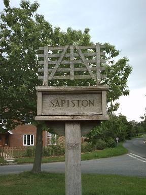
Sapiston is a small village and civil parish in the West Suffolk district of Suffolk in eastern England, located near the Suffolk-Norfolk border. It is in northern Suffolk lying on the river Blackbourn. The place-name 'Sapiston' is first attested in the Domesday Book of 1086, where it appears as ''Sapestuna''. The name is thought to mean 'village of soapmakers', but this is not certain. Eilert Ekwall, ''The Concise Oxford Dictionary of English Place-names'', p.404. Sapiston is bordered to the south-west by Honington, to the north-west by Fakenham Magna, to the north by Euston, to the east by Bardwell, and to the south by Ixworth Thorpe. It is 8 miles from Bury St Edmunds and 6 miles from Thetford in Norfolk. Also nearby are RAF Honington and two Joint RAF/USAF Bases, RAF Lakenheath and RAF Mildenhall. History :Sapiston, a parish in the hundred of Blackbourn, county Suffolk, 3½ miles N.W. of Ixworth, its post town, and 7 from Bury St. Edmund's. The village, which is ... [...More Info...] [...Related Items...] OR: [Wikipedia] [Google] [Baidu] |
Market Weston
Market Weston is a small village and civil parish in the West Suffolk district of Suffolk in eastern England. It is located near the Norfolk border around seven miles east-south-east of Thetford. In 2005 its population was estimated to be 260.Estimates of Total Population of Areas in Suffolk Suffolk County Council 245 people were recorded at 2011 census. The parish also contains the Weston Fen . The village was given a |
Knettishall
Knettishall is a village and civil parish in the West Suffolk district of Suffolk in eastern England. Located on the south bank of the River Little Ouse (the Norfolk-Suffolk border), in 2005 it had a population of 40. From the 2011 census the population of the village was not maintained and it is included in the civil parish of neighbouring Hopton. The parish contains Knettishall Heath Country Park and the remains of RAF Knettishall, a World War II World War II or the Second World War, often abbreviated as WWII or WW2, was a world war that lasted from 1939 to 1945. It involved the vast majority of the world's countries—including all of the great powers—forming two opposin ... airfield. References External links Hopton-cum-Knettishall Parish Council [...More Info...] [...Related Items...] OR: [Wikipedia] [Google] [Baidu] |
Hopton, Suffolk
Hopton is a village and civil parish in the West Suffolk district of Suffolk in eastern England. Located just south of the Norfolk border on the B1111 road between Stanton and Garboldisham, in 2005 it had a population of 650. It shares a parish council with neighbouring Knettishall. All Saints' Church is at the geographical centre of the village, it has regular services and is part of the United Benefice of Stanton, Hopton, Market Weston, Barningham & Coney Weston. Schools There is a primary school, and a pre-school. The primary school feeds students both to Thurston Community College in Thurston and Ixworth Free School in Ixworth Ixworth is a village and civil parish in the West Suffolk district of Suffolk, England, north-east of Bury St Edmunds on the A143 road to Diss and south-east of Thetford. The parish had a population of 2,365 at the 2011 Census. History I .... References External links Hopton cum Knettishall Parish Council [...More Info...] [...Related Items...] OR: [Wikipedia] [Google] [Baidu] |
Honington, Suffolk
Honington is a village and civil parish located in Bardwell Ward and Pakenham and Troston Wards of West Suffolk District Council, Suffolk in eastern England It is near to the border with Norfolk. It lies on the River Black Bourn, about 8 miles (13 km) from Bury St Edmunds and 6 miles (10 km) from Thetford, Norfolk. Much of the farmland belongs to the estate of the Duke of Grafton. The village is known for its RAF station, RAF Honington. It is also near two joint RAF/USAF airfields: RAF Lakenheath and RAF Mildenhall. Honington was the birthplace of the poet Robert Bloomfield. Position Honington is bordered to the north-east by Sapiston, to the north-west by Fakenham Magna, to the north by Euston, to the east by Bardwell, to the south-west by Troston, and to the south by Ixworth Thorpe. History The existence of the village is recorded in the Domesday Book. Before the dissolution of the monasteries under Henry VIII in the late 1530s, the land in the village ... [...More Info...] [...Related Items...] OR: [Wikipedia] [Google] [Baidu] |


.jpg)


