|
Boulder Creek, California
Boulder Creek is a small rural mountain community in the coastal Santa Cruz Mountains. It is a census-designated place (CDP) in Santa Cruz County, California, with a population of 5,429 as of the 2020 census. Throughout its history, Boulder Creek has been home to a logging town and a resort community, as well as a counter-culture haven. Today, it is identified as the gateway town to Big Basin Redwoods State Park. History The Boulder Creek area is in the traditional tribal territory of the Awaswas people, of which there are no living survivors and are spoken for by the Amah Mutsun Tribal Band. According to one anthropologist, the indigenous name for the area was ''Achista'' and tentatively included ''Acsaggi''. The cultural unit, Ohlone, to which the Boulder Creek natives belonged were part of a contiguous set of bands that inhabited the coastal region of present-day California from the San Francisco Bay to the Monterey Peninsula and down to San José and Salinas Valley. ... [...More Info...] [...Related Items...] OR: [Wikipedia] [Google] [Baidu] |
Census-designated Place
A census-designated place (CDP) is a Place (United States Census Bureau), concentration of population defined by the United States Census Bureau for statistical purposes only. CDPs have been used in each decennial census since 1980 as the counterparts of incorporated places, such as self-governing city (United States), cities, town (United States), towns, and village (United States), villages, for the purposes of gathering and correlating statistical data. CDPs are populated areas that generally include one officially designated but currently unincorporated area, unincorporated community, for which the CDP is named, plus surrounding inhabited countryside of varying dimensions and, occasionally, other, smaller unincorporated communities as well. CDPs include small rural communities, Edge city, edge cities, colonia (United States), colonias located along the Mexico–United States border, and unincorporated resort and retirement community, retirement communities and their environs. ... [...More Info...] [...Related Items...] OR: [Wikipedia] [Google] [Baidu] |
Area Code 831
Area code 831 is a telephone area code in the North American Numbering Plan (NANP) for a small region of the U.S. state of California. The numbering plan area (NPA) comprises Monterey County, San Benito County, and Santa Cruz County. The area code was created on July 11, 1998 in a split from area code 408. Service area The service area of NPA 831 includes Big Sur, Monterey Bay, the Salinas Valley, and the southwestern Santa Cruz Mountains. Major cities in the area are Salinas, Hollister, Monterey, Santa Cruz and places in the northern Central Coast. Monterey County * Aromas * Boronda * Carmel Highlands * Carmel Valley Village * Carmel-by-the-Sea * Castroville * Chualar * Del Monte Forest * Del Rey Oaks * Elkhorn * Gonzales * Gorda * Greenfield * Jolon * King City * Las Lomas * Lockwood * Marina * Monterey * Moss Landing * Pacific Grove * Pajaro * Pebble Beach * Prunedale * Salinas * San Ardo * San Lucas * Sand City * Seaside * Soledad * Spreckel ... [...More Info...] [...Related Items...] OR: [Wikipedia] [Google] [Baidu] |
Rancho Zayante
Rancho Zayante was a Mexican land grant in present-day Santa Cruz County, California. The grant, measuring one league by one-half league (2,658 acres), straddled Zayante Creek and the San Lorenzo River. It included most of the present-day communities of Felton, Mount Hermon and Olympia, along with parts of Ben Lomond, Quail Hollow and Brackney, but not Zayante. History Rancho Zayante was granted in 1834 by Governor José Figueroa to Joaquin Buelna, who had been a teacher in San Jose and alcalde of Branciforte (part of today's city of Santa Cruz). Buelna never occupied the land and the grant lapsed. It was re-granted in 1841 by Governor Juan Alvarado to Joseph Ladd Majors. Joseph Ladd Majors (1806–1868), a trapper from Tennessee, came to California in 1834 over the Santa Fe Trail in a party that included Isaac Graham. In 1838, Majors became a naturalized Mexican citizen and, at least temporarily, changed his name to Juan José Crisostomo Mayor. In 1839, Majors married Ma ... [...More Info...] [...Related Items...] OR: [Wikipedia] [Google] [Baidu] |
Mission San Juan Bautista
Mission San Juan Bautista is a Spanish mission in San Juan Bautista, San Benito County, California. Founded on June 24, 1797 by Fermín Lasuén of the Franciscan order, the mission was the fifteenth of the Spanish missions established in present-day California. Named for Saint John the Baptist, the mission is the namesake of the city of San Juan Bautista. Barracks for the soldiers, a nunnery, the Jose Castro House, and other buildings were constructed around a large grassy plaza in front of the church and can be seen today in their original form. The Ohlone, the original residents of the valley, were brought to live at the mission and baptized, followed by Yokuts from the Central Valley. Mission San Juan Bautista has served mass daily since 1797, and today functions as a parish church of the Diocese of Monterey. History Following its creation in 1797, San Juan's population grew quickly. By 1803, there were 1,036 Native Americans living at the mission. Ranching and farmi ... [...More Info...] [...Related Items...] OR: [Wikipedia] [Google] [Baidu] |
Mission Santa Clara De Asís
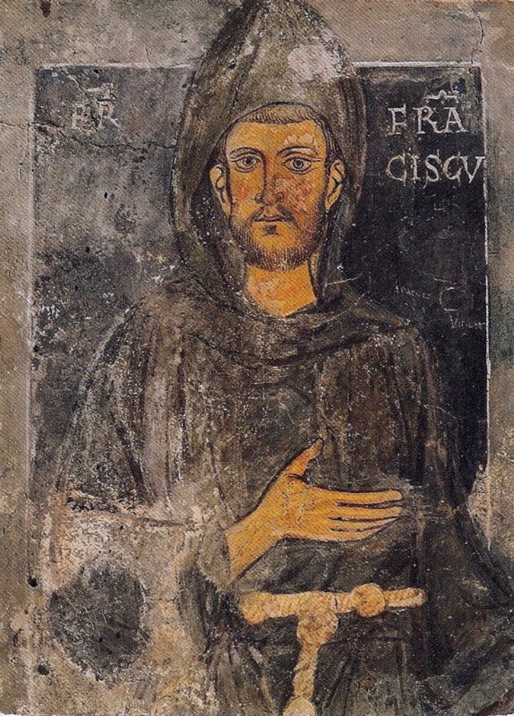
Mission Santa Clara de Asís ( es, Misión Santa Clara de Asís) is a Spanish mission in the city of Santa Clara, California. The mission, which was the eighth in California, was founded on January 12, 1777, by the Franciscan order. Named for Saint Clare of Assisi, who founded the order of the Poor Clares and was an early companion of St. Francis of Assisi, this was the first California mission to be named in honor of a woman. It is the namesake of both the city and county of Santa Clara, as well as of Santa Clara University, which was built around the mission. This is the only mission located on the grounds of a university campus. Although ruined and rebuilt six times, the settlement was never abandoned, and today it functions as the university chapel for Santa Clara University. History The outpost was originally established as ''La Misión Santa Clara de Thamien'' (or ''Mission Santa Clara de Thamien'', a reference to the Tamien people) at the Indian village of ''So-co ... [...More Info...] [...Related Items...] OR: [Wikipedia] [Google] [Baidu] |
Franciscans
, image = FrancescoCoA PioM.svg , image_size = 200px , caption = A cross, Christ's arm and Saint Francis's arm, a universal symbol of the Franciscans , abbreviation = OFM , predecessor = , merged = , formation = , founder = Francis of Assisi , founding_location = , extinction = , merger = , type = Mendicant Order of Pontifical Right for men , status = , purpose = , headquarters = Via S. Maria Mediatrice 25, 00165 Rome, Italy , location = , coords = , region = , services = , membership = 12,476 members (8,512 priests) as of 2020 , language = , sec_gen = , leader_title = Motto , leader_name = ''Pax et bonum'' ''Peace and llgood'' , leader_title2 = Minister General , leader_name2 = ... [...More Info...] [...Related Items...] OR: [Wikipedia] [Google] [Baidu] |
Mission Santa Cruz
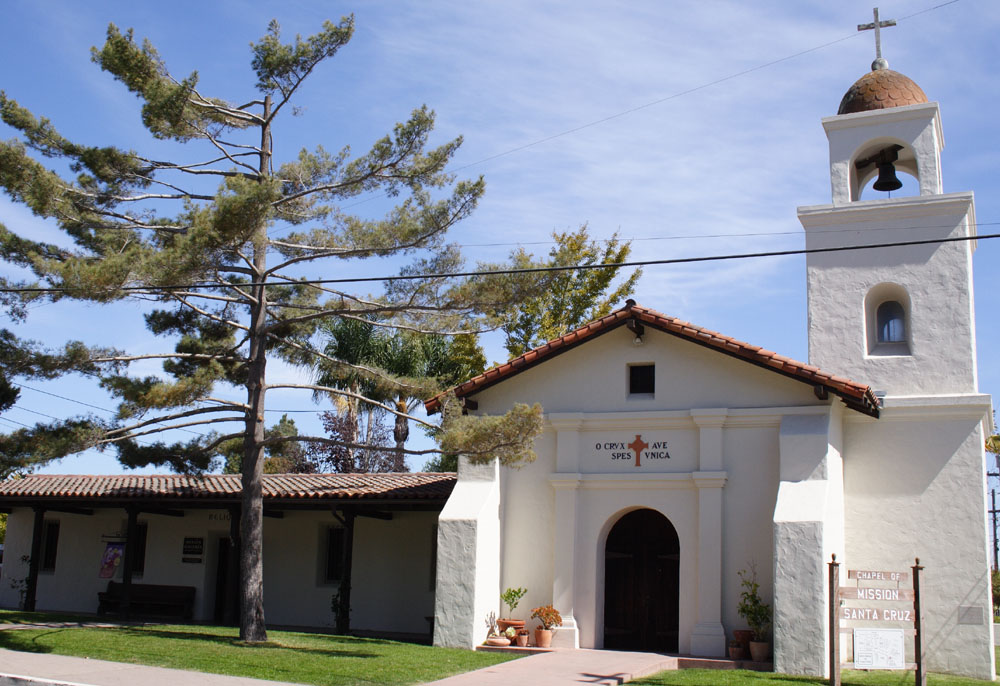
Mission Santa Cruz (''La Misión de la Exaltación de la Santa Cruz'', which translates as the Mission of the Exaltation of the Holy Cross), was the twelfth of twenty-one Spanish missions in California (today's U.S. state), established by the Franciscan order in present-day Santa Cruz, California. The mission was dedicated in 1791 by Father Fermín de Lasuén, second president of the Alta California missions. The mission was named for the feast of the Exaltation of the Cross, adopting the name given to a nearby creek by the missionary priest Juan Crespi, who accompanied the explorer Gaspar de Portolá when he camped on the banks of the San Lorenzo River on October 17, 1769.Yenne, p. 112 As with the other California missions, Mission Santa Cruz served as a site for ecclesiastical conversion of natives, first the people, the original inhabitants of the region (called ''Costeño'' by the Spaniards, and later known as the "Ohlone"). Later, Yokuts people were brought from the east ... [...More Info...] [...Related Items...] OR: [Wikipedia] [Google] [Baidu] |
Gaspar De Portolá
Gaspar de Portolá y Rovira (January 1, 1716 – October 10, 1786) was a Spanish military officer, best known for leading the Portolá expedition into California and for serving as the first Governor of the Californias. His expedition laid the foundations of important Californian cities like San Diego and Monterey, and bestowed names to geographic features throughout California, many of which are still in use. Early life Gaspar de Portolá y Rovira, known in Catalan as Gaspar Portolà i Rovira, was born on 1 January 1716 in Os de Balaguer, in Catalonia, to a family of minor Catalan nobility. Gaspar served as a soldier in the Spanish army in Italy and Portugal. He was commissioned ensign in 1734, and lieutenant in 1743. Following the expulsion of the Jesuits from the Spanish Empire, Portolá was tasked with removing the Jesuits from the Spanish missions in Baja California. He then ensured the missions were turned over to the Franciscans and later to the Dominicans. Exp ... [...More Info...] [...Related Items...] OR: [Wikipedia] [Google] [Baidu] |
Ohlone
The Ohlone, formerly known as Costanoans (from Spanish meaning 'coast dweller'), are a Native American people of the Northern California coast. When Spanish explorers and missionaries arrived in the late 18th century, the Ohlone inhabited the area along the coast from San Francisco Bay through Monterey Bay to the lower Salinas Valley. At that time they spoke a variety of related languages. The Ohlone languages make up a sub-family of the Utian language family. Older proposals place Utian within the Penutian language phylum, while newer proposals group it as Yok-Utian. In pre-colonial times, the Ohlone lived in more than 50 distinct landholding groups, and did not view themselves as a single unified group. They lived by hunting, fishing, and gathering, in the typical ethnographic California pattern. The members of these various bands interacted freely with one another. The Ohlone people practiced the Kuksu religion. Prior to the Gold Rush, the northern California r ... [...More Info...] [...Related Items...] OR: [Wikipedia] [Google] [Baidu] |
Awaswas
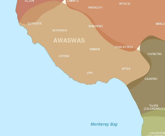
The Awaswas people, also known as Santa Cruz people, are one of eight divisions of the Ohlone Native Americans of Northern California. The Awaswas lived in the Santa Cruz Mountains and along the coast of present-day Santa Cruz County from present-day Davenport to Aptos. The name for this area in Awaswas was Aulinta. Historically, they spoke the Awaswas language, one of the Costanoan language dialects in the Utian family, which became the main language spoken at the Mission Santa Cruz. However, there is evidence that this grouping was more geographic than linguistic, and that the records of the 'Santa Cruz Costanoan' language in fact represent several diverse dialects. The Awaswas territory was bordered by the Pacific Ocean to the west, and other Ohlone people on all other sides: the Ramaytush to the north, Tamien to the east, and the Mutsun and Rumsien to the south. The Awaswas population living between Davenport and Aptos was estimated at 600 people in 1770. Mission ... [...More Info...] [...Related Items...] OR: [Wikipedia] [Google] [Baidu] |
Awaswas Map
The Awaswas people, also known as Santa Cruz people, are one of eight divisions of the Ohlone Native Americans of Northern California. The Awaswas lived in the Santa Cruz Mountains and along the coast of present-day Santa Cruz County from present-day Davenport to Aptos. The name for this area in Awaswas was Aulinta. Historically, they spoke the Awaswas language, one of the Costanoan language dialects in the Utian family, which became the main language spoken at the Mission Santa Cruz. However, there is evidence that this grouping was more geographic than linguistic, and that the records of the 'Santa Cruz Costanoan' language in fact represent several diverse dialects. The Awaswas territory was bordered by the Pacific Ocean to the west, and other Ohlone people on all other sides: the Ramaytush to the north, Tamien to the east, and the Mutsun and Rumsien to the south. The Awaswas population living between Davenport and Aptos was estimated at 600 people in 1770. Mission ... [...More Info...] [...Related Items...] OR: [Wikipedia] [Google] [Baidu] |
Big Basin Redwoods State Park
Big Basin Redwoods State Park is a state park in the U.S. state of California, located in Santa Cruz County, about northwest of Santa Cruz. The park contains almost all of the Waddell Creek watershed, which was formed by the seismic uplift of its rim, and the erosion of its center by the many streams in its bowl-shaped depression. Big Basin is California's oldest State Park, established in 1902, earning its designation as a California Historical Landmark. Its original have been increased over the years to over . It is part of the Northern California coastal forests ecoregion and is home to the largest continuous stand of ancient coast redwoods south of San Francisco. It contains of old-growth forest as well as recovering redwood forest, with mixed conifer, oaks, chaparral and riparian habitats. Elevations in the park vary from sea level to over 600 m (2,000 ft). The climate ranges from foggy and damp near the ocean to sunny, warm ridge tops. The park has ove ... [...More Info...] [...Related Items...] OR: [Wikipedia] [Google] [Baidu] |

.jpg)


