|
Bondelswarts
The Bondelswarts are a Nama people, Nama ethnic group of Southern Africa living in the extreme south of Namibia, in an area centred on the town of Warmbad, Namibia, Warmbad.''Big Swords, Jesuits, and Bondelswarts'', John S. Lowry, p.64 History They rose up against German colonial rule in the Herero and Namaqua genocide, Nama War 1903-1906. They were brutally repressed. They inhabit an arid region around Fish River Canyon and the Richtersveld. In 1922 they were involved in the Bondelswarts Rebellion, a revolt against a tax on dogs, which was violently repressed. References Notes Further reading * * John S. Lowry, ''Big Swords, Jesuits, and Bondelswarts'', 2015. * Brian Wood, ''Namibia 1884-1984: Readings on Namibia's History and Society'', Namibia Support Committee, United Nations Institute for Namibia, 1988 * Alfred T. Moleah, ''Namibia, the Struggle for Liberation'', 1983 * Dean McCleland, ''John Dunn: Part 1 – Background to the Bondelswarts People & the SAC' Na ... [...More Info...] [...Related Items...] OR: [Wikipedia] [Google] [Baidu] |
Bondelswarts Rebellion
The Bondelswarts Rebellion in 1922 (aka the Bondelswarts Uprising or Bondelswarts Affair) was a controversial violent incident in South Africa's League of Nations Mandate of South West Africa, now Namibia. In 1917, the South African mandatory administration had created a tax on dogs, and they increased it in 1921. The tax was rejected by the Bondelswarts, a group of Khoikhoi, who were opposed to various policies of the new administration. They were also protecting five men for whom arrest warrants had been issued. There is disagreement over the details of the dispute, but according to historian Neta Crawford, "most agree that in May 1922 the Bondelswarts prepared to fight, or at least to defend themselves, and the mandatory administration moved to crush what they called a rebellion of 500 to 600 people, of which 200 were said to be armed (although only about 40 weapons were captured after the Bondelswarts were crushed)". Gysbert Reitz Hofmeyr, the Mandatory Administrator of South ... [...More Info...] [...Related Items...] OR: [Wikipedia] [Google] [Baidu] |
Nama People
Nama (in older sources also called Namaqua) are an African ethnic group of South Africa, Namibia and Botswana. They traditionally speak the Nama language of the Khoe-Kwadi language family, although many Nama also speak Afrikaans. The Nama People (or Nama-Khoe people) are the largest group of the Khoikhoi people, most of whom have disappeared as a group, except for the Namas. Many of the Nama clans live in Central Namibia and the other smaller groups live in Namaqualand, which today straddles the Namibian border with South Africa. History For thousands of years, the Khoisan peoples of South Africa and southern Namibia maintained a nomadic life, the Khoikhoi as pastoralists and the San people as hunter-gatherers. The Nama are a Khoikhoi group. The Nama originally lived around the Orange River in southern Namibia and northern South Africa. The early colonialists referred to them as Hottentots. Their alternative historical name, "Namaqua", stems from the addition of the Khoekhoe ... [...More Info...] [...Related Items...] OR: [Wikipedia] [Google] [Baidu] |
Herero And Namaqua Genocide
The Herero and Namaqua genocide or the Herero and Nama genocide was a campaign of ethnic extermination and collective punishment waged by the German Empire against the Herero (Ovaherero) and the Nama in German South West Africa (now Namibia). It was the first genocide of the 20th century, occurring between 1904 and 1908. In January 1904, the Herero people, who were led by Samuel Maharero, and the Nama people, who were led by Captain Hendrik Witbooi, rebelled against German colonial rule. On January 12, they killed more than 100 German settlers in the area of Okahandja, although women, children, missionaries and non-German Europeans were spared. In August, German General Lothar von Trotha defeated the Ovaherero in the Battle of Waterberg and drove them into the desert of Omaheke, where most of them died of dehydration. In October, the Nama people also rebelled against the Germans, only to suffer a similar fate. Between 24,000 and 100,000 Hereros and 10,000 Nama died in the g ... [...More Info...] [...Related Items...] OR: [Wikipedia] [Google] [Baidu] |
Southern Africa
Southern Africa is the southernmost subregion of the African continent, south of the Congo and Tanzania. The physical location is the large part of Africa to the south of the extensive Congo River basin. Southern Africa is home to a number of river systems; the Zambezi River being the most prominent. The Zambezi flows from the northwest corner of Zambia and western Angola to the Indian Ocean on the coast of Mozambique. Along the way, the Zambezi River flows over the mighty Victoria Falls on the border between Zambia and Zimbabwe. Victoria Falls is one of the largest waterfalls in the world and a major tourist attraction for the region. Southern Africa includes both subtropical and temperate climates, with the Tropic of Capricorn running through the middle of the region, dividing it into its subtropical and temperate halves. Countries commonly included in Southern Africa include Angola, Botswana, the Comoros, Eswatini, Lesotho, Madagascar, Malawi, Mauritius, Mozambique, Namib ... [...More Info...] [...Related Items...] OR: [Wikipedia] [Google] [Baidu] |
Namibia
Namibia (, ), officially the Republic of Namibia, is a country in Southern Africa. Its western border is the Atlantic Ocean. It shares land borders with Zambia and Angola to the north, Botswana to the east and South Africa to the south and east. Although Kazungula, it does not border Zimbabwe, less than 200 metres (660 feet) of the Botswanan right bank of the Zambezi, Zambezi River separates the two countries. Namibia gained independence from South Africa on 21 March 1990, following the Namibian War of Independence. Its capital and largest city is Windhoek. Namibia is a member state of the United Nations (UN), the Southern African Development Community (SADC), the African Union (AU) and the Commonwealth of Nations. The driest country in sub-Saharan Africa, Namibia has been inhabited since pre-historic times by the San people, San, Damara people, Damara and Nama people. Around the 14th century, immigration, immigrating Bantu peoples arrived as part of the Bantu expansion. Since ... [...More Info...] [...Related Items...] OR: [Wikipedia] [Google] [Baidu] |
Warmbad, Namibia
Warmbad (Afrikaans and German for ''Warm Bath'', Nama: , Aixa-aibes) is a settlement located in the ǁKaras Region of southern Namibia. It is situated south of Karasburg at the Homs River, close to the border with South Africa, and belongs to the Karasburg electoral constituency. First occupied by traders, hunters, and missionaries of different congregations, the hot springs from which the settlement's name is derived were first exploited at the beginning of the 20th century and are now being developed into a tourist attraction. , uranium was discovered in the area. Climatically, Warmbad lies between the coastal desert and the Karoo. There is winter frost and very little rainfall (annual average: ), the mean medial temperature lies between 12 and 15 degrees. History Pre-colonial period Warmbad was first named in 1760 by scout Jacobus Coetzee, the first documented European to cross the Oranje River into the South West African territory that today forms the state of Namibi ... [...More Info...] [...Related Items...] OR: [Wikipedia] [Google] [Baidu] |
Fish River Canyon
The Fish River Canyon (Afrikaans: ''Visrivier Canyon'' or'' Visrivier Kuil'', german: Fischfluss Canyon), is located in the south of Namibia. It is the largest canyon in Africa, as well as the second most visited tourist attraction in Namibia.Matador Trips - 27 of the deepest canyons you can experience. It features a gigantic ravine, in total about long, up to 27 km wide and in places almost 550 meters deep. The Fish River is the longest interior river in Namibia. It cuts deep into the plateau which is today dry, stony and sparsely covered with hardy drought-resistant plants. The river flows intermittently, usually flooding in late summer; the rest of the year it becomes a chain of long narrow pools. At the lower end of the Fish River Canyon, the hot springs resort of ǀAi-ǀAis is situated. Public view points are near Hobas, a camp site 70 km north of ǀAi-ǀAis. This part of the canyon is part of the ǀAi-ǀAis/Richtersveld Transfrontier Park. The other 90 k ... [...More Info...] [...Related Items...] OR: [Wikipedia] [Google] [Baidu] |
Richtersveld
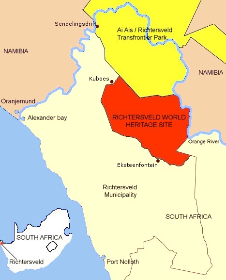
The Richtersveld is a desert landscape characterised by rugged kloofs and high mountains, situated in the north-western corner of South Africa’s Northern Cape province. It is full of changing scenery from flat, sandy, coastal plains, to craggy sharp mountains of volcanic rock and the lushness of the Orange River, which forms the border with neighboring Namibia. The area ranges in altitude from sea level, to at Cornellberg. Located in the north-western side of the Northern Cape province in South Africa, the Richtersveld is regarded as the only arid biodiversity hotspot on earth and the majority of the area is inscribed on UNESCO's World Heritage List due to its cultural values. The Nama people of Richtersveld claimed title to their traditional land and set aside this conservancy for future research and tourism. The northern part of the area was proclaimed in 1991 after 18 years of negotiations between the National Parks Board and the local Nama people who continue to liv ... [...More Info...] [...Related Items...] OR: [Wikipedia] [Google] [Baidu] |
Ethnic Groups In Namibia
Namibia (, ), officially the Republic of Namibia, is a country in Southern Africa. Its western border is the Atlantic Ocean. It shares land borders with Zambia and Angola to the north, Botswana to the east and South Africa to the south and east. Although it does not border Zimbabwe, less than 200 metres (660 feet) of the Botswanan right bank of the Zambezi River separates the two countries. Namibia gained independence from South Africa on 21 March 1990, following the Namibian War of Independence. Its capital and largest city is Windhoek. Namibia is a member state of the United Nations (UN), the Southern African Development Community (SADC), the African Union (AU) and the Commonwealth of Nations. The driest country in sub-Saharan Africa, Namibia has been inhabited since pre-historic times by the San, Damara and Nama people. Around the 14th century, immigrating Bantu peoples arrived as part of the Bantu expansion. Since then, the Bantu groups, the largest being the Ovambo, ... [...More Info...] [...Related Items...] OR: [Wikipedia] [Google] [Baidu] |


