|
Bhiman
Bhiman (Nepali भिमान ) is a town in Kamalamai Municipality Ward no. 11 in Sindhuli District in the Janakpur Zone of south-eastern Nepal. At the time of the 1991 Nepal census it had a population of 7,609 people living in 1,389 individual households. Geography Bhiman is an important town in Sindhuli District as it is a gateway to the district from terai region of Nepal. It is at a distance of 19 Kilometers from Bardibas. Bhiman is located on B.P. Koirala Highway, and is only 18 Kilometers from district headquarter Sindhulimadi. Bhiman - Katahari road passes through the town. The town of Bhiman lies close to the bank of Kamala River. A small seasonal river Bhiman Khola also flows near the town. Bhiman is located at . Education Bhiman is an important educational hub in Sindhuli district. Bhiman has a number of schools from primary level to college level. Bhiman has three secondary schools and a primary school, Shri Jana Jagriti Higher Secondary School and campus, Sc ... [...More Info...] [...Related Items...] OR: [Wikipedia] [Google] [Baidu] |
Sindhuli District
Sindhuli District ( ne, सिन्धुली जिल्ला), a part of the Bagmati Province, is one of the seventy-seven districts of Nepal, a landlocked country of South Asia. The district, with Sindhulimadhi Kamalamai as its district headquarters and covers an area of . In 2001, it had a population of 279,821, in 2011 the population was 296,192.Household and population by districts, Central Bureau of Statistics (CBS) Nepal 
Etymology i) Before being annexed as an integral part of Nepal, it was under the governance ...[...More Info...] [...Related Items...] OR: [Wikipedia] [Google] [Baidu] |
Kamalamai
Kamalamai (former name: Sindhulimadi; ne, सिन्धुलीमाडी) is a municipality in Sindhuli District, in the Bagmati Province of central south Nepal. At the time of the 2011 Nepal census it had a population of 39,413 people in 9,304 households. The city is located in the Sindhuli Valley of central south Nepal. The historic symbol of the valley, Sindhuli Gadhi fort, is at the peak of a hill of the Mahabharata range. The city is in the plain valley made by the Kamla River. Kamalamai Municipality is the largest municipality of Nepal according to area. History The occupation of the Kuti Pass in about 1756 stopped the valley's trade with Tibet. Finally, King Prithvi Narayan Shah entered the valley after the victory of Kirtipur. King Jaya Prakash Malla of Kathmandu sought help from the British and so the East India Company sent a contingent of soldiers under Captain Kinloch in 1767. The British force was defeated at Sindhuli by Prithvi Narayan Shah's army. It was th ... [...More Info...] [...Related Items...] OR: [Wikipedia] [Google] [Baidu] |
Municipality
A municipality is usually a single administrative division having corporate status and powers of self-government or jurisdiction as granted by national and regional laws to which it is subordinate. The term ''municipality'' may also mean the governing body of a given municipality. A municipality is a general-purpose administrative subdivision, as opposed to a special-purpose district. The term is derived from French and Latin . The English word ''municipality'' derives from the Latin social contract (derived from a word meaning "duty holders"), referring to the Latin communities that supplied Rome with troops in exchange for their own incorporation into the Roman state (granting Roman citizenship to the inhabitants) while permitting the communities to retain their own local governments (a limited autonomy). A municipality can be any political jurisdiction, from a sovereign state such as the Principality of Monaco, to a small village such as West Hampton Dunes, New York. Th ... [...More Info...] [...Related Items...] OR: [Wikipedia] [Google] [Baidu] |
Kamala River
The Kamala River (Hindi and ne, कमला नदी kamalā nadī) originates from Nepal and flows through Indian state of Bihar. Course The Kamala originates from Churia Range near Maithan which is near Sindhuli Gadhi in Sindhuli District of Nepal at an elevation of . It flows in a southerly direction crossing Kamala Khoj area and after passing through a gorge above Chauphat it flows into the terai area of Nepal at Chisapani. The Kamala forms the border between Siraha and Dhanusa districts in the terai. During the monsoon the river swells up and thus causes devastating river bank erosion. Tao River and Baijnath Khola River merges with Kamala at Maini It enters Indian territory in Madhubani district in Bihar, upstream of Jainagar. A barrage known as Kamala barrage has been constructed by the State Government near Jainagar. It joins the river Kareh (Bagmati) at Badlaghat in Khagaria district and the combined stream flows into the Koshi nearby. While one of its branches ... [...More Info...] [...Related Items...] OR: [Wikipedia] [Google] [Baidu] |
Biratnagar
Biratnagar () is a metropolitan city in Nepal, which serves as the capital of Province No. 1. With a population of 242,548 as per the 2011 census, it is the largest city in the province and also the headquarters of Morang district. As per the preliminary report of 2021 Nepal census, Biratnagar has an estimated city population of 244,750. It is one of the cities of the ''Greater Birat Development Area'' which incorporates the cities of Biratnagar-Itahari-Gothgau- Biratchowk-Dharan primarily located on the Koshi Highway in Eastern Nepal, with an estimated total urban agglomerated population of 804,300 people living in 159,332 households. Biratnagar is located east of the capital, Kathmandu, and north of the bordering town of Jogbani in the Indian state of Bihar. Biratnagar was declared a metropolitan city on 22 May 2017, a merger with additional wards pushing the total population to over 240,000. It is the sixth most populous city of Nepal after Kathmandu, Pokhara, Bharatpu ... [...More Info...] [...Related Items...] OR: [Wikipedia] [Google] [Baidu] |
Pokhara
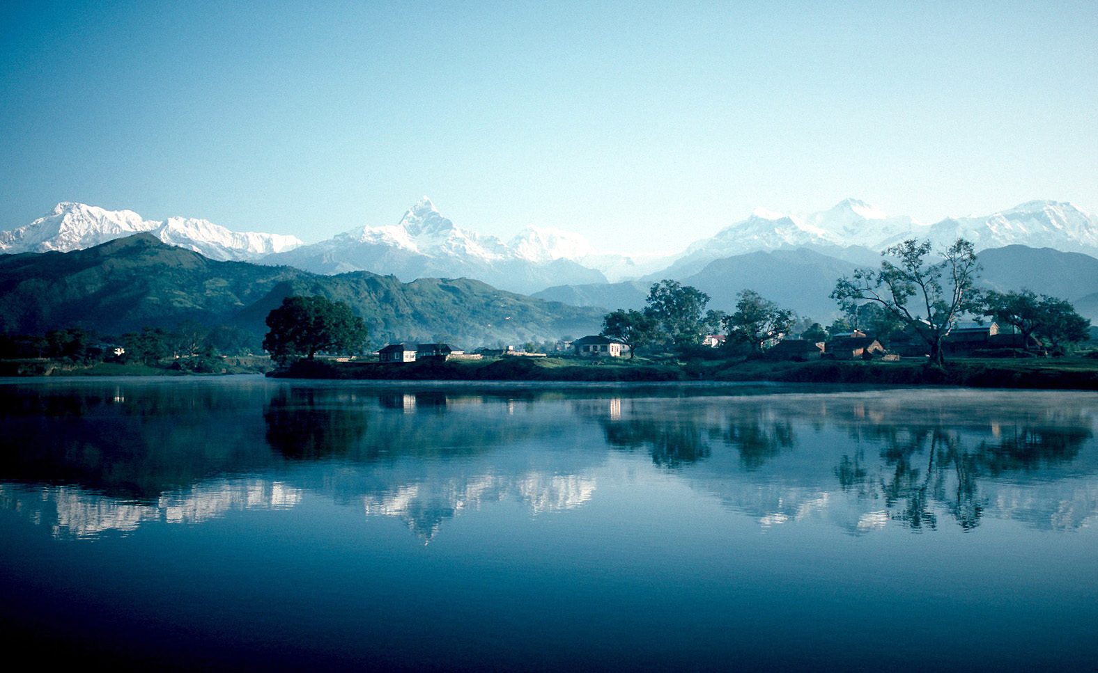
Pokhara ( ne, पोखरा, ) is a metropolis, metropolitan city in Nepal, which serves as the capital of Gandaki Province. It is the List of cities in Nepal, second most populous city of Nepal after Kathmandu, with 518,452 inhabitants living in 101,669 households in 2021 Nepal census, 2021. It is the country's largest metropolitan city in terms of area. The city also serves as the headquarters of Kaski District. Pokhara is located west of the capital, Kathmandu. The city is on the shore of Phewa Lake, and sits at an elevation of approximately 822m. The Annapurna Range, with three out of the ten highest peaks in the world—Dhaulagiri, Annapurna, Annapurna I and Manaslu—is within of the valley. Pokhara is considered the tourism capital of Nepal, being a base for trekkers undertaking the Annapurna Circuit through the Annapurna Conservation Area region of the Annapurna ranges in the Himalayas. The city is also home to many of the elite Gurkha soldiers, soldiers native to So ... [...More Info...] [...Related Items...] OR: [Wikipedia] [Google] [Baidu] |
Kathmandu
, pushpin_map = Nepal Bagmati Province#Nepal#Asia , coordinates = , subdivision_type = Country , subdivision_name = , subdivision_type1 = Province , subdivision_name1 = Bagmati Province , subdivision_type2 = District , subdivision_name2 = Kathmandu , established_title = , founder = Manjushri , parts_type = No. of Wards , parts = 32 , seat_type = , seat = , government_footnotes = , government_type = Mayor–council government , governing_body = Kathmandu Metropolitan Government, , leader_title = Mayor , leader_name = Balendra Shah ( Ind.) , leader_title1 = Deputy mayor , leader_name1 = Sunita Dangol (UML) , leader_title2 = Executive Officer , leader_name2 = Basanta Adhikari , unit_pref ... [...More Info...] [...Related Items...] OR: [Wikipedia] [Google] [Baidu] |
Mahendra Highway
Mahendra Highway (), also called East-West Highway () runs across the Terai geographical region of Nepal, from Mechinagar in the east to Bhim Datta in the west, cutting across the entire width of the country. It is the longest highway in Nepal and was constructed by cooperation of various countries. Overview The highway is mostly a single lane in each direction. It is a major infrastructure element because east–west travel was previously limited to the Hulaki Highway built during the Rana regime, expensive and limited air travel, or Nepalese trains and buses. The highway crosses the Terai from east to west for over . Connecting Nepal from Kakarbhitta (Mechinagar Municipality) to West Mahendra Nagar in the east, this is the longest highway in Nepal till now. Bharatpur city and Chitwan valley are located towards the central part of this highway. The major destinations along and around the highway are Mechinagar, Bhadrapur, Itahari, Janakpur, Bharatpur, Butwal, Siddharthanag ... [...More Info...] [...Related Items...] OR: [Wikipedia] [Google] [Baidu] |
Tribhuwan University
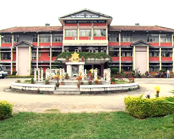
Tribhuvan University (TU; ne, त्रिभुवन विश्वविद्यालय) is a public university located in Kirtipur, Kathmandu. Established in 1959, TU is the oldest university in Nepal. In terms of enrollment, it is the 12th largest university in the world. The college offers 1000 undergraduate and 500 postgraduate programs across a wide range of disciplines. Additionally, the institution has 30 constituent campuses and over 600 affiliated colleges across the country. Because it is government-funded, the tuition fees are less expensive than those of private (affiliated) college campuses. History Established on 25 June 1959 (or 11 Ashar 2016 BS), Tribhuvan University is the oldest and largest university in Nepal. The university was named after the late King Tribhuvan. In its early years, all the postgraduate classes were held at Tripureshwor Campus. The administrative office was also located in Tripureshwor. It was only in 1967 that the university was ... [...More Info...] [...Related Items...] OR: [Wikipedia] [Google] [Baidu] |
Digital Himalaya
The Digital Himalaya project was established in December 2000 by Mark Turin, Alan Macfarlane, Sara Shneiderman, and Sarah Harrison. The project's principal goal is to collect and preserve historical multimedia materials relating to the Himalaya, such as photographs, recordings, and journals, and make those resources available over the internet and offline, on external storage media. The project team have digitized older ethnographic collections and data sets that were deteriorating in their analogue formats, so as to protect them from deterioration and make them available and accessible to originating communities in the Himalayan region and a global community of scholars. The project was founded at the Department of Anthropology of the University of Cambridge, moved to Cornell University in 2002 (when a collaboration with the University of Virginia was initiated), and then back to the University of Cambridge in 2005. From 2011 to 2014, the project was jointly hosted between the Uni ... [...More Info...] [...Related Items...] OR: [Wikipedia] [Google] [Baidu] |
Bardibas
Bardibas is a municipal area (municipality) and a town located in Mahottari District of Madhesh Province of Nepal. It is located at latitude: 26°54'6.84" to 27°08'46.90" and longitude: 85°47'42.67" to 85°56'42.97". The municipality is surrounded by Dhanusha District in the East and Sarlahi District in the West, Bagmati Province falls in the North and Bhangaha, Aurahi and Gaushala municipalities are located in the South. Total population of the municipality in 2011 Nepal census) had 66354 and total area of the municipality is . In 2021 census the population of Bardibas increased to 68353. The municipality is divided into total 14 wards. The municipality was established on 2 December 2014 merging the then four VDCs of Bardibas, Maisthan, Gauribas and Kisan Nagar. In 2015, when Government of Nepal decided to dissolve the old thousands of VDCs and declare new 753 local level body then four more VDCs were merged with this municipality, those municipalities were: Hathilet, ... [...More Info...] [...Related Items...] OR: [Wikipedia] [Google] [Baidu] |


