|
Banat Krajina
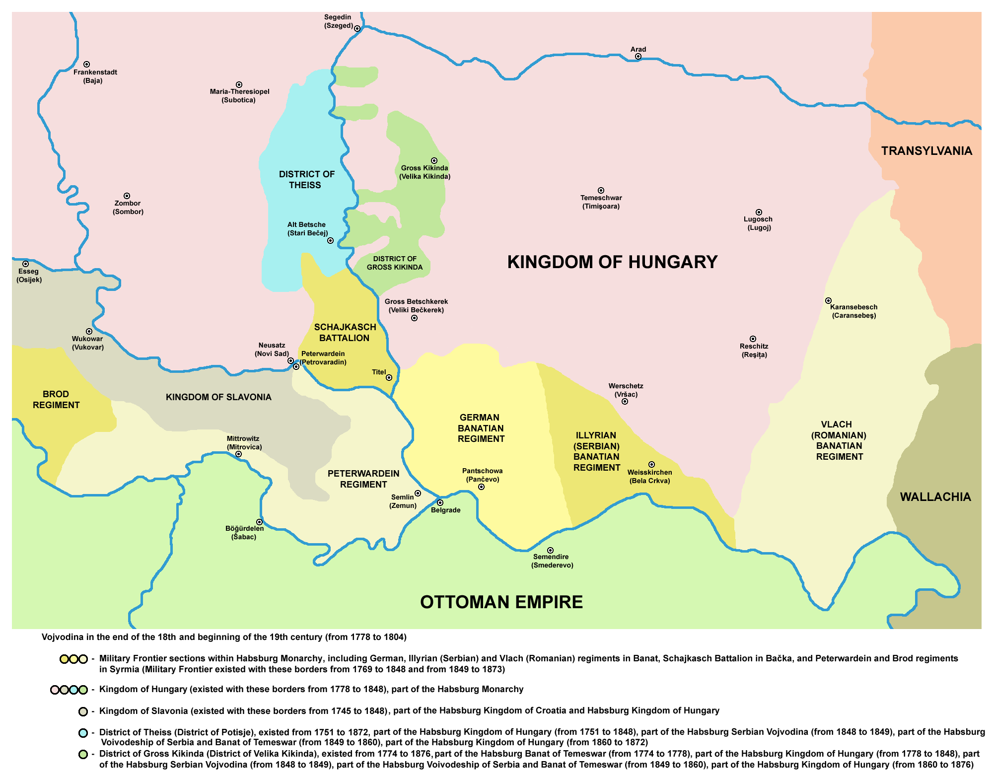
The Banat Military Frontier or simply Banat Frontier ( sr, Банатска крајина/Banatska krajina; ro, Granița militară Bănățeană) was a district of the Habsburg monarchy's Military Frontier located in the Banat region. It was formed out of territories of the Banat of Temeswar. Today, the territory is split between Hungary, Serbia and Romania. Geography The Frontier was divided into Serb (''Illyrian''), German ('' Danube Swabian'') and Romanian (''Vlach'') sections. It included parts of modern-day Banat and the south-eastern part of Bačka region, known as Šajkaška. Some of the important cities and places were: Pančevo, Bela Crkva, Titel, Žabalj, Alibunar, Kovin, and Caransebeş. History The military province of Habsburg monarchy known as the Banat of Temeswar was created in 1718. In 1751, Maria Theresa introduced a civil administration for the northern part of the province. The southern part remained under military administration and was organized as the B ... [...More Info...] [...Related Items...] OR: [Wikipedia] [Google] [Baidu] |
Administrative Divisions
Administrative division, administrative unit,Article 3(1). country subdivision, administrative region, subnational entity, constituent state, as well as many similar terms, are generic names for geographical areas into which a particular, independent sovereign state (country) is divided. Such a unit usually has an administrative authority with the power to take administrative or policy decisions for its area. Usually, the countries have several levels of administrative divisions. The common names for the principal (largest) administrative divisions are: states (i.e. "subnational states", rather than sovereign states), provinces, lands, oblasts, governorates, cantons, prefectures, counties, regions, departments, and emirates. These, in turn, are often subdivided into smaller administrative units known by names such as circuits, counties, ''comarcas'', raions, '' județe'', or districts, which are further subdivided into the municipalities, communes or communities consti ... [...More Info...] [...Related Items...] OR: [Wikipedia] [Google] [Baidu] |
Titel
Titel ( sr-Cyrl, Тител, hu, Titel) is a town and municipality located in the South Bačka District of the province of Vojvodina, Serbia. The town of Titel has a population of 5,247, while the population of the municipality of Titel is 15,738. It is located in southeastern part of the geographical region of Bačka, known as Šajkaška. Name In Serbian, the town is known as ''Titel'' (Тител), in Hungarian as ''Titel'', in German as ''Titel'' (and sometimes ''Theisshügel''), and in Latin as ''Titulium''. History The Titel Plateau is an elevated region between the Danube and Tisza rivers, close to the confluence; about ; roughly . It has an ellipsoid form and is characterized by steep slopes at the margins. It has a substantial loess cover and is often called the Titel Loess Plateau; the loess on the plateau is considered to contain the most detailed terrestrial palaeoclimate records in Europe, with a thick and apparently continuous record extending to the middle and ... [...More Info...] [...Related Items...] OR: [Wikipedia] [Google] [Baidu] |
Bela Crkva, Banat
Bela Crkva ( sr-cyrl, Бела Црква, ; german: Weißkirchen; hu, Fehértemplom; ro, Biserica Albă) is a town and municipality located in the South Banat District of the autonomous province of Vojvodina, Serbia. The town has a population of 8,868, while the Bela Crkva municipality has 17,285 inhabitants. Bela Crkva lakes at the outskirts of the town are a popular summer tourist destination. Name The name of the town ''Bela Crkva'' means "white church" in Serbian. In Romanian, the town is known as ''Biserica Albă'' (formerly Albești), in German as ''Weißkirchen'', in Hungarian as ''Fehértemplom'' (formerly Fejéregyház), and in Turkish as ''Aktabya''. History Neolithic findings of ceramics and burial with Greek-style pots dating to late fifth century BC are founded in the area. The town was founded in 1717 when this region was included into the Habsburg monarchy. It was part of the Banatian Military Frontier of the Monarchy and, since 1774, was a seat of the ... [...More Info...] [...Related Items...] OR: [Wikipedia] [Google] [Baidu] |
Caransebeș
Caransebeș (; german: Karansebesch; hu, Karánsebes, Hungarian pronunciation: ) is a municipiu, city in Caraș-Severin County, part of the Banat region in southwestern Romania. It is located at the confluence of the Timiș (river), River Timiș with the Sebeș River (Timiș), River Sebeș, the latter coming from the Țarcu Mountains. To the west, it is in direct contact with the Banat Hills. It is an important railroad node, being located approximately 40 km away from Reșița, 21 km from Oțelu Roșu, 70 km from Hațeg and about 25 km from the Muntele Mic ski resort, in the Țarcu Mountains. One village, Jupa ( hu, Zsuppa), is administered by the city. Climate Caransebeș has a humid continental climate (''Cfb'' in the Köppen climate classification). It is rather mild. Sub-Mediterranean climatic influences are present to some extent. Temperatures do not drop too low in winter (with an average of 0,-15 °C), but summers can be warm (30-38 °C avera ... [...More Info...] [...Related Items...] OR: [Wikipedia] [Google] [Baidu] |
Slavonian Military Frontier
The Slavonian Military Frontier ( hr, Slavonska vojna krajina or ; german: Slawonische Militärgrenze; sr, Славонска војна крајина; hu, Szlavón határőrvidék) was a district of the Military Frontier, a territory in the Habsburg monarchy, first during the period of the Austrian Empire and then during the Austro-Hungarian Monarchy. It was formed out of territories the Habsburgs conquered from the Ottoman Empire and included southern parts of Slavonia and Syrmia; today the area it covered is mostly in eastern Croatia, with its easternmost parts in northern Serbia (mostly in Vojvodina region). Divisions The Slavonian Military Frontier was divided between three regiments: Regiment N°VII, based at Vinkovci; Regiment N°VIII, based at Nova Gradiška and Regiment N°IX, based at Petrovaradin. Other important towns in the area included Sremski Karlovci, Stara Pazova, Zemun, and Sremska Mitrovica. History During the history, name Slavonian Military Fronti ... [...More Info...] [...Related Items...] OR: [Wikipedia] [Google] [Baidu] |
Wallachia
Wallachia or Walachia (; ro, Țara Românească, lit=The Romanian Land' or 'The Romanian Country, ; archaic: ', Romanian Cyrillic alphabet: ) is a historical and geographical region of Romania. It is situated north of the Lower Danube and south of the Southern Carpathians. Wallachia is traditionally divided into two sections, Muntenia (Greater Wallachia) and Oltenia (Lesser Wallachia). Dobruja could sometimes be considered a third section due to its proximity and Dobruja#Wallachian rule, brief rule over it. Wallachia as a whole is sometimes referred to as Muntenia through identification with the larger of the two traditional sections. Wallachia was founded as a principality in the early 14th century by Basarab I of Wallachia, Basarab I after a rebellion against Charles I of Hungary, although the first mention of the territory of Wallachia west of the river Olt River, Olt dates to a charter given to the voivode Seneslau in 1246 by Béla IV of Hungary. In 1417, Wallachia was fo ... [...More Info...] [...Related Items...] OR: [Wikipedia] [Google] [Baidu] |
Transylvania
Transylvania ( ro, Ardeal or ; hu, Erdély; german: Siebenbürgen) is a historical and cultural region in Central Europe, encompassing central Romania. To the east and south its natural border is the Carpathian Mountains, and to the west the Apuseni Mountains. Broader definitions of Transylvania also include the western and northwestern Romanian regions of Crișana and Maramureș, and occasionally Banat. Transylvania is known for the scenery of its Carpathian landscape and its rich history. It also contains Romania's second-largest city, Cluj-Napoca, and other iconic cities and towns such as Brașov, Sibiu, Târgu Mureș, Alba Iulia and Sighișoara. It is also the home of some of Romania's List of World Heritage Sites in Romania, UNESCO World Heritage Sites such as the villages with fortified churches in Transylvania, Villages with fortified churches, the Historic Centre of Sighișoara, the Dacian Fortresses of the Orăștie Mountains and the Rosia Montana Mining Cultural Landsc ... [...More Info...] [...Related Items...] OR: [Wikipedia] [Google] [Baidu] |
Voivodeship Of Serbia And Banat Of Temeschwar
, conventional_long_name = Voivodeship of Serbia and Temes Banate , common_name = Serbia and Banat , subdivision = Crownland , nation = the Austrian Empire , year_start = 1849 , date_start = 18 November , year_end = 1860 , date_end = 27 December , event_start = , event_end = , government_type = Voivodeship , p1 = Serbian Vojvodina , flag_p1 = Flag of Serbian Vojvodina.svg , p2 = Kingdom of Hungary (1526–1867) , flag_p2 = Flag of the Habsburg Monarchy.svg , s1 = Austrian Empire , flag_s1 = Flag of the Habsburg Monarchy.svg , s2 = , flag_s2 = , s3 = , image_flag = Flag of Serbian Vojvodina.svg , flag = Flag of Vojvodina , image_coat = Coat of arms of Serbian Vojvodina.svg , symbol = Coat of arms of Vojvodina , image_map = Wojwodowena und Banat.jpg , today = SerbiaRomaniaHungary , capital = Temeschwar , currency = The Voivodeship of Serbia and Banat of Temeschwar or Serbia ... [...More Info...] [...Related Items...] OR: [Wikipedia] [Google] [Baidu] |
Principality Of Serbia
The Principality of Serbia ( sr-Cyrl, Књажество Србија, Knjažestvo Srbija) was an autonomous state in the Balkans that came into existence as a result of the Serbian Revolution, which lasted between 1804 and 1817. Its creation was negotiated first through an unwritten agreement between Miloš Obrenović I, Prince of Serbia, Miloš Obrenović, leader of the Second Serbian Uprising, and Ottoman Empire, Ottoman official Marashli Pasha. It was followed by the series of legal documents published by the Sublime Porte in 1828, 1829 and finally, 1830—the Hatt-i Sharif. Its ''de facto'' independence ensued in 1867, following the evacuation of the remaining Ottoman troops from the Belgrade Fortress and the country; its independence was recognized internationally in 1878 by the Treaty of Berlin (1878), Treaty of Berlin. In 1882 the country was elevated to the status of Kingdom of Serbia, kingdom. Background and establishment The Serbian revolutionary leaders—first Karađ ... [...More Info...] [...Related Items...] OR: [Wikipedia] [Google] [Baidu] |
Maria Theresa Of Austria
Maria Theresa Walburga Amalia Christina (german: Maria Theresia; 13 May 1717 – 29 November 1780) was ruler of the Habsburg monarchy, Habsburg dominions from 1740 until her death in 1780, and the only woman to hold the position ''suo jure'' (in her own right). She was the sovereign of Archduchy of Austria, Austria, Kingdom of Hungary, Hungary, Kingdom of Croatia (Habsburg), Croatia, Crown of Bohemia, Bohemia, Principality of Transylvania (1711–1867), Transylvania, Duchy of Mantua, Mantua, Duchy of Milan, Milan, Kingdom of Galicia and Lodomeria, Lodomeria and Galicia, the Austrian Netherlands, and Duchy of Parma, Parma. By marriage, she was Duchess of Lorraine, Grand Duchess of Tuscany and Holy Roman Empress. Maria Theresa started her 40-year reign when her father, Emperor Charles VI, died on 20 October 1740. Charles VI paved the way for her accession with the Pragmatic Sanction of 1713 and spent his entire reign securing it. He neglected the advice of Prince Eugene of Savoy, ... [...More Info...] [...Related Items...] OR: [Wikipedia] [Google] [Baidu] |


