|
Ballymoreen
Ballymurreen (), also written Ballymoreen, is a civil parish and an electoral division in County Tipperary, Ireland. It is one of 21 civil parishes in the barony of Eliogarty. As a Church of Ireland parish, it was in the diocese of Cashel. The ruins of a church are still to be seen in Ballymurreen townland, at the junction of a minor road from Holycross with the R639, but there was no parish church in modern times, members of the established church attending services in the neighbouring parish of Borrisleigh, at Littleton which is located between the exclave of Rathcunikeen and the main part of Ballymoreen. Electoral division The code number assigned to the electoral division by the Central Statistics Office is 22062. At the time of both the 1911 census, the division was smaller than the civil parish of the same name, containing just three townlands ( Curraheen, Parkstown and Liskeveen) of the seven that belong to the civil parish; the four other townlands from B ... [...More Info...] [...Related Items...] OR: [Wikipedia] [Google] [Baidu] |
Ballymoreen (civil Parish)
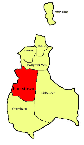
Ballymurreen (), also written Ballymoreen, is a civil parish and an electoral division in County Tipperary, Ireland. It is one of 21 civil parishes in the barony of Eliogarty. As a Church of Ireland parish, it was in the diocese of Cashel. The ruins of a church are still to be seen in Ballymurreen townland, at the junction of a minor road from Holycross with the R639, but there was no parish church in modern times, members of the established church attending services in the neighbouring parish of Borrisleigh, at Littleton which is located between the exclave of Rathcunikeen and the main part of Ballymoreen. Electoral division The code number assigned to the electoral division by the Central Statistics Office is 22062. At the time of both the 1911 census, the division was smaller than the civil parish of the same name, containing just three townlands ( Curraheen, Parkstown and Liskeveen) of the seven that belong to the civil parish; the four other townlands from Ball ... [...More Info...] [...Related Items...] OR: [Wikipedia] [Google] [Baidu] |
Littleton (electoral Division)
Littleton is an electoral division in County Tipperary in Ireland. The code number assigned it by the Central Statistics Office is 22071. Electoral divisions were originally created in the 1830s as part of the implementation of the Poor Laws. Neighbouring divisions, such as Moycarkey, Ballymurreen, Rahealty and Twomileborris were created to help elect the Board of Guardians for the Thurles poor law union; however Littleton division was not created at that time. When it was finally created (which must have been before 1911 because it was used in the census that year and was probably before the 1891 census because the 1911 returns compared the divisional population with that in 1891 and 1901, which would have been meaningless if the areas were different), it was assembled from townlands taken from neighbouring divisions. Relationship to civil parishes At the time of both the 1911 and the 2011 census, the division included townlands from several civil parishes: Galbooly, Ball ... [...More Info...] [...Related Items...] OR: [Wikipedia] [Google] [Baidu] |
Eliogarty
Eliogarty (Irish: ''Éile Uí Fhógarta'') is a barony in County Tipperary, Ireland. This geographical unit of land is one of 12 baronies in County Tipperary. Its chief town is Thurles. The barony lies between Ikerrin to the north (whose chief town is Roscrea), Kilnamanagh Upper to the west (whose chief town is Borrisoleigh), Middle Third to the south (whose chief town is Cashel) and County Kilkenny to the east. It is currently administered by Tipperary County Council. Legal context Baronies were created after the Norman invasion of Ireland as divisions of counties and were used the administration of justice and the raising of revenue. While baronies continue to be officially defined units, they have been administratively obsolete since 1898. However, they continue to be used in land registration and in specification, such as in planning permissions. In many cases, a barony corresponds to an earlier Gaelic túath which had submitted to the Crown. This is probably true in the ca ... [...More Info...] [...Related Items...] OR: [Wikipedia] [Google] [Baidu] |
List Of Civil Parishes Of Ireland
Civil parishes in Ireland are based on the medieval Christian parishes, adapted by the English administration and by the Church of Ireland. The parishes, their division into townlands and their grouping into baronies, were recorded in the Down Survey undertaken in 1656-58 by surveyors under William Petty. The purpose was primarily cadastral, recording land boundaries and ownership. The civil parishes are not administrative units. They differ from Catholic parishes, which are generally larger. Antrim There are 77 civil parishes in County Antrim. *Aghagallon *Aghalee * Ahoghill * Antrim *Ardclinis *Armoy *Ballinderry *Ballintoy * Ballyclug * Ballycor * Ballylinny * Ballymartin *Ballymoney *Ballynure *Ballyrashane *Ballyscullion *Ballyscullion Grange * Ballywillin * Billy *Blaris * Camlin *Carncastle *Carnmoney *Carrickfergus (or St Nicholas) * Connor *Cranfield * Culfeightrin * Derryaghy *Derrykeighan * Doagh Grange *Donegore * Drumbeg *Drummaul * Drumtullagh, Grange of * Dunaghy ... [...More Info...] [...Related Items...] OR: [Wikipedia] [Google] [Baidu] |
Parkstown
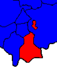
Parkstown is a townland in County Tipperary in Ireland. Occupying 624 acres, it is located in the civil parish of Ballymoreen in the barony of Eliogarty in the poor law union of Thurles. Its name in Irish, ''Baile na Páirce'', was, in mid-20th century, used as the official Irish name of the village of Horse and Jockey, the northern half of which is built on the townland, at its south-western corner; it appeared on official road-signs and was the name used in the postmark at the post office in the village. Parkstown House There is a townland house or estate house, ''Parkstown House''. The Lamphier family lived at Parkstown House from at least the 1770s; Thomas John Lanphier was the freeholder in 1776. Henry Langley lived there in 1814 and John Pennefather Lamphier was living there in 1837 and in the early 1850s; he held the property, whose buildings were valued at more than £23, from the Court of Chancery and was the occupant at the time of its sale in 1852. The Parkstown ... [...More Info...] [...Related Items...] OR: [Wikipedia] [Google] [Baidu] |
Curraheen, Ballymoreen
Curraheen is a townland in County Tipperary in Ireland. Occupying 895 acres, it is located in the civil parish of Ballymoreen in the barony of Eliogarty in the poor law union of Thurles Thurles (; ''Durlas Éile'') is a town in County Tipperary, Ireland. It is located in the civil parish of the same name in the barony of Eliogarty and in the ecclesiastical parish of Thurles (Roman Catholic parish), Thurles. The cathedral ch .... {Dead link, date=December 2023 , bot=InternetArchiveBot , fix-attempted=yes References [...More Info...] [...Related Items...] OR: [Wikipedia] [Google] [Baidu] |
Ballymoreen (townland)
Ballymoreen, or Ballymurreen (), is a townland in the civil parish of the same name in County Tipperary in Ireland. It is within the historical barony of Eliogarty in the south-east corner of North Tipperary, between Littleton and Horse and Jockey. Evidence of ancient settlement in Ballymurreen include a number of ringfort sites, a ruined church and graveyard dating to at least the 17th century, and the former site of a tower house and bawn A bawn is the defensive wall surrounding an Irish tower house. It is the anglicised version of the Irish word ''bábhún'' (sometimes spelt ''badhún''), possibly meaning "cattle-stronghold" or "cattle-enclosure".See alternative traditional spe .... The townland, which is in area, had a population of 65 as of the 2011 census. References Townlands of County Tipperary Eliogarty {{Tipperary-geo-stub ... [...More Info...] [...Related Items...] OR: [Wikipedia] [Google] [Baidu] |
Liskeveen, County Tipperary
Liskeveen, also written Liskevin or Liscaveen, is a townland in County Tipperary in Ireland. Occupying 1453 acres, it is located in the civil parish of Ballymoreen in the barony of Eliogarty Eliogarty (Irish: ''Éile Uí Fhógarta'') is a barony in County Tipperary, Ireland. This geographical unit of land is one of 12 baronies in County Tipperary. Its chief town is Thurles. The barony lies between Ikerrin to the north (whose chief to ... in the poor law union of Thurlesl. There are two estate houses in the townland. Heathview House was marked on the first edition of the Ordnance Survey map as Liskeveen House. The house now called Liskeveen House was marked on the first edition of the Ordnance Survey map as Fanny Ville. in the Landed Estates Database at the National University ... [...More Info...] [...Related Items...] OR: [Wikipedia] [Google] [Baidu] |
Parkstown, County Tipperary
Parkstown is a townland in County Tipperary in Ireland. Occupying 624 acres, it is located in the civil parish of Ballymoreen in the barony of Eliogarty in the poor law union of Thurles. Its name in Irish, ''Baile na Páirce'', was, in mid-20th century, used as the official Irish name of the village of Horse and Jockey, the northern half of which is built on the townland, at its south-western corner; it appeared on official road-signs and was the name used in the postmark at the post office in the village. Parkstown House There is a townland house or estate house, ''Parkstown House''. The Lamphier family lived at Parkstown House from at least the 1770s; Thomas John Lanphier was the freeholder in 1776. Henry Langley lived there in 1814 and John Pennefather Lamphier was living there in 1837 and in the early 1850s; he held the property, whose buildings were valued at more than £23, from the Court of Chancery and was the occupant at the time of its sale in 1852. The Par ... [...More Info...] [...Related Items...] OR: [Wikipedia] [Google] [Baidu] |
Curraheen, Thurles, County Tipperary
Curraheen is a townland in County Tipperary in Ireland. Occupying 895 acres, it is located in the civil parish of Ballymoreen in the barony of Eliogarty in the poor law union of Thurles Thurles (; ''Durlas Éile'') is a town in County Tipperary, Ireland. It is located in the civil parish of the same name in the barony of Eliogarty and in the ecclesiastical parish of Thurles (Roman Catholic parish), Thurles. The cathedral ch .... {Dead link, date=December 2023 , bot=InternetArchiveBot , fix-attempted=yes References [...More Info...] [...Related Items...] OR: [Wikipedia] [Google] [Baidu] |
Rathcunikeen
Rathcunikeen or Rathcumrikeen is a townland in the civil parish of Ballymurreen, County Tipperary in Ireland. It is an exclave of the parish, as it is surrounded by the neighbouring civil parish of Two-Mile-Borris Two-Mile Borris (also written Twomileborris or Two Mile Borris; and locally Borris or TMB) is a village in County Tipperary, Ireland. The village is located on the L4202 road at the junction with the Ballyduff Road, close to the N75 and from .... References {{reflist Townlands of County Tipperary ... [...More Info...] [...Related Items...] OR: [Wikipedia] [Google] [Baidu] |
Rahinch, County Tipperary
Rathinch is a townland A townland ( ga, baile fearainn; Ulster-Scots: ''toonlann'') is a small geographical division of land, historically and currently used in Ireland and in the Western Isles in Scotland, typically covering . The townland system is of Gaelic origi ... in the civil parish of Ballymurreen, County Tipperary. At the time of the 1911 census, there were three households, containing people of four different surnames (Delaney, Woodlock, Kearney and Cass) in the townland. According to death notices appearing in 2012, the townland still contained people bearing the two latter surnames. References {{reflist Townlands of County Tipperary ... [...More Info...] [...Related Items...] OR: [Wikipedia] [Google] [Baidu] |


