|
Ballymoreen (civil Parish)
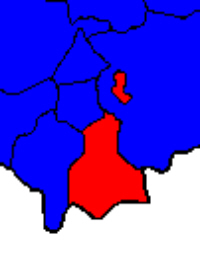
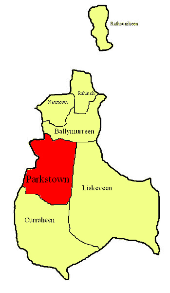
Ballymurreen (), also written Ballymoreen, is a civil parish and an electoral division in County Tipperary, Ireland. It is one of 21 civil parishes in the barony of Eliogarty. As a Church of Ireland parish, it was in the diocese of Cashel. The ruins of a church are still to be seen in Ballymurreen townland, at the junction of a minor road from Holycross with the R639, but there was no parish church in modern times, members of the established church attending services in the neighbouring parish of Borrisleigh, at Littleton which is located between the exclave of Rathcunikeen and the main part of Ballymoreen. Electoral division The code number assigned to the electoral division by the Central Statistics Office is 22062. At the time of both the 1911 census, the division was smaller than the civil parish of the same name, containing just three townlands ( Curraheen, Parkstown and Liskeveen) of the seven that belong to the civil parish; the four other townlands from Ball ... [...More Info...] [...Related Items...] OR: [Wikipedia] [Google] [Baidu] |
Central Statistics Office (Ireland)
The Central Statistics Office (CSO; ga, An Phríomh-Oifig Staidrimh) is the statistical agency responsible for the gathering of "information relating to economic, social and general activities and conditions" in Ireland, in particular the National Census which is held every five years. The office is answerable to the Taoiseach and has its main offices in Cork.The Director General of the CSO is Pádraig Dalton. History The CSO was established on a statutory basis in 1994 to reduce the number of separate offices responsible for collecting statistics for the state. The CSO had existed, as an independent ad hoc office within the Department of the Taoiseach since June 1949, and its work greatly increased in the following decades particularly from 1973 with Ireland joining the European Community. Previous to the 1949 reforms, statistics were collected by the Statistics Branch of Department of Industry and Commerce on the creation of the Irish Free State in 1922. The Statistics Bra ... [...More Info...] [...Related Items...] OR: [Wikipedia] [Google] [Baidu] |
Ordnance Survey Ireland
Ordnance Survey Ireland (OSI; ga, Suirbhéireacht Ordanáis Éireann) is the national mapping agency of Ireland. It was established on 4 March 2002 as a body corporate. It is the successor to the former Ordnance Survey of Ireland. It and the Ordnance Survey of Northern Ireland (OSNI) are the ultimate successors to the Irish operations of the British Ordnance Survey. OSI is part of the Irish public service. OSI has made modern and historic maps of the state free to view on its website. OSI is headquartered at Mountjoy House in the Phoenix Park in Dublin. Mountjoy House was also the headquarters, until 1922, of the Irish section of the British Ordnance Survey. Organisation Under the Ordnance Survey Ireland Act 2001, the Ordnance Survey of Ireland was dissolved and a new corporate body called Ordnance Survey Ireland was established in its place. OSI is now an autonomous corporate body, with a remit to cover its costs of operation from its sales of data and derived products, wh ... [...More Info...] [...Related Items...] OR: [Wikipedia] [Google] [Baidu] |
Acre
The acre is a unit of land area used in the imperial Imperial is that which relates to an empire, emperor, or imperialism. Imperial or The Imperial may also refer to: Places United States * Imperial, California * Imperial, Missouri * Imperial, Nebraska * Imperial, Pennsylvania * Imperial, Texa ... and United States customary units#Units of area, US customary systems. It is traditionally defined as the area of one Chain (unit), chain by one furlong (66 by 660 feet), which is exactly equal to 10 square chains, of a square mile, 4,840 square yards, or 43,560 square feet, and approximately 4,047 m2, or about 40% of a hectare. Based upon the International yard and pound, international yard and pound agreement of 1959, an acre may be declared as exactly 4,046.8564224 square metres. The acre is sometimes abbreviated ac but is usually spelled out as the word "acre".National Institute of Standards and Technolog(n.d.) General Tables of Units of Measurement . Traditionally, i ... [...More Info...] [...Related Items...] OR: [Wikipedia] [Google] [Baidu] |
Rathcunikeen
Rathcunikeen or Rathcumrikeen is a townland in the civil parish of Ballymurreen, County Tipperary in Ireland. It is an exclave of the parish, as it is surrounded by the neighbouring civil parish of Two-Mile-Borris Two-Mile Borris (also written Twomileborris or Two Mile Borris; and locally Borris or TMB) is a village in County Tipperary, Ireland. The village is located on the L4202 road at the junction with the Ballyduff Road, close to the N75 and from .... References {{reflist Townlands of County Tipperary ... [...More Info...] [...Related Items...] OR: [Wikipedia] [Google] [Baidu] |
Rahinch, County Tipperary
Rathinch is a townland A townland ( ga, baile fearainn; Ulster-Scots: ''toonlann'') is a small geographical division of land, historically and currently used in Ireland and in the Western Isles in Scotland, typically covering . The townland system is of Gaelic origi ... in the civil parish of Ballymurreen, County Tipperary. At the time of the 1911 census, there were three households, containing people of four different surnames (Delaney, Woodlock, Kearney and Cass) in the townland. According to death notices appearing in 2012, the townland still contained people bearing the two latter surnames. References {{reflist Townlands of County Tipperary ... [...More Info...] [...Related Items...] OR: [Wikipedia] [Google] [Baidu] |
Parkstown
Parkstown is a townland in County Tipperary in Ireland. Occupying 624 acres, it is located in the civil parish of Ballymoreen in the barony of Eliogarty in the poor law union of Thurles. Its name in Irish, ''Baile na Páirce'', was, in mid-20th century, used as the official Irish name of the village of Horse and Jockey, the northern half of which is built on the townland, at its south-western corner; it appeared on official road-signs and was the name used in the postmark at the post office in the village. Parkstown House There is a townland house or estate house, ''Parkstown House''. The Lamphier family lived at Parkstown House from at least the 1770s; Thomas John Lanphier was the freeholder in 1776. Henry Langley lived there in 1814 and John Pennefather Lamphier was living there in 1837 and in the early 1850s; he held the property, whose buildings were valued at more than £23, from the Court of Chancery and was the occupant at the time of its sale in 1852. The Parkstown ... [...More Info...] [...Related Items...] OR: [Wikipedia] [Google] [Baidu] |
Newtown, Ballymurreen
Newtown, Eliogarty (Ballymurreen) is a townland in the Barony of Eliogarty in County Tipperary, Ireland. It is in the civil parish of Ballymurreen. It is one of 19 townlands known as Newtown (Irish Irish may refer to: Common meanings * Someone or something of, from, or related to: ** Ireland, an island situated off the north-western coast of continental Europe ***Éire, Irish language name for the isle ** Northern Ireland, a constituent unit ...: ''An Baile Nua'') in County Tipperary. References Townlands of County Tipperary {{Tipperary-geo-stub ... [...More Info...] [...Related Items...] OR: [Wikipedia] [Google] [Baidu] |
Curraheen, Ballymoreen
Curraheen is a townland in County Tipperary in Ireland. Occupying 895 acres, it is located in the civil parish of Ballymoreen in the barony of Eliogarty in the poor law union of Thurles Thurles (; ''Durlas Éile'') is a town in County Tipperary, Ireland. It is located in the civil parish of the same name in the barony of Eliogarty and in the ecclesiastical parish of Thurles (Roman Catholic parish), Thurles. The cathedral ch .... {Dead link, date=December 2023 , bot=InternetArchiveBot , fix-attempted=yes References [...More Info...] [...Related Items...] OR: [Wikipedia] [Google] [Baidu] |
Townland
A townland ( ga, baile fearainn; Ulster-Scots: ''toonlann'') is a small geographical division of land, historically and currently used in Ireland and in the Western Isles in Scotland, typically covering . The townland system is of Gaelic origin, pre-dating the Norman invasion, and most have names of Irish origin. However, some townland names and boundaries come from Norman manors, plantation divisions, or later creations of the Ordnance Survey.Connolly, S. J., ''The Oxford Companion to Irish History, page 577. Oxford University Press, 2002. ''Maxwell, Ian, ''How to Trace Your Irish Ancestors'', page 16. howtobooks, 2009. The total number of inhabited townlands in Ireland was 60,679 in 1911. The total number recognised by the Irish Place Names database as of 2014 was 61,098, including uninhabited townlands, mainly small islands. Background In Ireland a townland is generally the smallest administrative division of land, though a few large townlands are further divided into h ... [...More Info...] [...Related Items...] OR: [Wikipedia] [Google] [Baidu] |
Littleton (electoral Division)
Littleton is an electoral division in County Tipperary in Ireland. The code number assigned it by the Central Statistics Office is 22071. Electoral divisions were originally created in the 1830s as part of the implementation of the Poor Laws. Neighbouring divisions, such as Moycarkey, Ballymurreen, Rahealty and Twomileborris were created to help elect the Board of Guardians for the Thurles poor law union; however Littleton division was not created at that time. When it was finally created (which must have been before 1911 because it was used in the census that year and was probably before the 1891 census because the 1911 returns compared the divisional population with that in 1891 and 1901, which would have been meaningless if the areas were different), it was assembled from townlands taken from neighbouring divisions. Relationship to civil parishes At the time of both the 1911 and the 2011 census, the division included townlands from several civil parishes: Galbooly, Ball ... [...More Info...] [...Related Items...] OR: [Wikipedia] [Google] [Baidu] |
Liskeveen, County Tipperary
Liskeveen, also written Liskevin or Liscaveen, is a townland in County Tipperary in Ireland. Occupying 1453 acres, it is located in the civil parish of Ballymoreen in the barony of Eliogarty Eliogarty (Irish: ''Éile Uí Fhógarta'') is a barony in County Tipperary, Ireland. This geographical unit of land is one of 12 baronies in County Tipperary. Its chief town is Thurles. The barony lies between Ikerrin to the north (whose chief to ... in the poor law union of Thurlesl. There are two estate houses in the townland. Heathview House was marked on the first edition of the Ordnance Survey map as Liskeveen House. The house now called Liskeveen House was marked on the first edition of the Ordnance Survey map as Fanny Ville. in the Landed Estates Database at the National University ... [...More Info...] [...Related Items...] OR: [Wikipedia] [Google] [Baidu] |


