|
Bussell Island
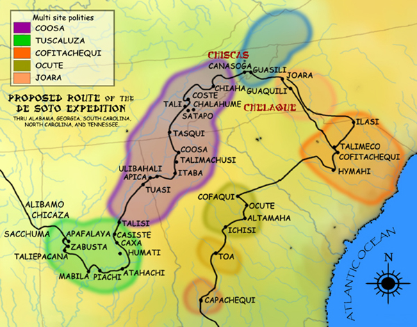
Bussell Island, formerly Lenoir Island, is an island located at the mouth of the Little Tennessee River, at its confluence with the Tennessee River in Loudon County, near the U.S. city of Lenoir City, Tennessee. The island was inhabited by various Native American cultures for thousands of years before the arrival of early European explorers. The Tellico Dam and a recreational area occupy part of the island. Part of the island was added in 1978 to the National Register of Historic Places for its archaeological potential. Native American habitation of Bussell Island dates to the Late Archaic period (c. 3000–1000 BC).Bobby Braly and Shannon KoernerA History of Archaeology in Tennessee. ''Tennessee Archaeology: A Synthesis'' (Chapter 2). p. 12-14. The island is believed to have been the location of the capital of ''Coste''—a Mississippian-period chiefdom visited by Spanish explorer Hernando de Soto in 1540—and was later part of the domain of the Overhill Cherokee and the r ... [...More Info...] [...Related Items...] OR: [Wikipedia] [Google] [Baidu] |
Loudon County, Tennessee
Loudon County is a county in the U.S. state of Tennessee. It is located in the central part of East Tennessee. As of the 2020 census, the population was 54,886. Its county seat is Loudon. Loudon County is included in the Knoxville, TN Metropolitan Statistical Area. History Loudon County was formed on May 27, 1870, from portions of Roane, Monroe and Blount counties.Joe Spence,Loudon County" ''Tennessee Encyclopedia of History and Culture''. Retrieved: 22 October 2013. Originally, it was named Christiana County, but a few days later the name was changed to Loudon in honor of nearby colonial-era Fort Loudoun. The fort was named for John Campbell, 4th Earl of Loudoun and a commander of British forces during the French and Indian Wars. In August 1870, the county officers were chosen. On September 5, 1870, the county court was organized at the Baptist Church in Loudon. This church became the temporary quarters of the county court until the new building, built by J. W. Clark ... [...More Info...] [...Related Items...] OR: [Wikipedia] [Google] [Baidu] |
Woodland Period
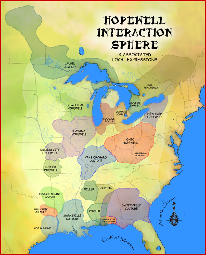
In the classification of :category:Archaeological cultures of North America, archaeological cultures of North America, the Woodland period of North American pre-Columbian cultures spanned a period from roughly 1000 Common Era, BCE to European contact in the eastern part of North America, with some archaeologists distinguishing the Mississippian period, from 1000 CE to European contact as a separate period. The term "Woodland Period" was introduced in the 1930s as a generic term for prehistoric, prehistoric sites falling between the Archaic period in the Americas, Archaic hunter-gatherers and the agriculturalist Mississippian cultures. The Eastern Woodlands cultural region covers what is now eastern Canada south of the Subarctic region, the Eastern United States, along to the Gulf of Mexico. This period is variously considered a developmental stage, a time period, a suite of technological adaptations or "traits", and a "family tree" of cultures related to earlier Archaic cultures. ... [...More Info...] [...Related Items...] OR: [Wikipedia] [Google] [Baidu] |
Coosa Chiefdom
The Coosa chiefdom was a powerful Native American paramount chiefdom in what are now Gordon and Murray counties in Georgia, in the United States."Late Prehistoric/Early Historic Chiefdoms (ca. A.D. 1300-1850)" ''''. Retrieved July 22, 2010. It was inhabited from about 1400 until about 1600, and dominated several smaller chiefdoms. The total population of Coosa's area of influence, reaching into present-day Tennessee and Alabama, has been estimated at 50,000. |
Vonore, Tennessee
Vonore is a town in Monroe County, Tennessee, Monroe County, which is located on the southeast border of the U.S. state of Tennessee. The population was 1,574 as of the 2020 United States census, 2020 census. The city hall, library, community center, police department, and fire department are located on Church Street. History Vonore developed at the confluence of the Little Tennessee River and the Tellico River, a place of indigenous settlement for thousands of years. It was a center of numerous Cherokee towns along the rivers. Vonore is near the center of one of the richest archaeological regions in the southeastern United States. The now-submerged Icehouse Bottom site was occupied by indigenous cultures in the region as early as 7500 B.C. The now-submerged Mialoquo (Cherokee town), Rose Island was home to a significant Woodland period (c. 1000 B.C. – 1000 A.D.) settlement. Later the Cherokee had the town there known as Mialoquo (Cherokee town), Mialoguo. A substantial M ... [...More Info...] [...Related Items...] OR: [Wikipedia] [Google] [Baidu] |
French Broad River
The French Broad River is a river in the U.S. states of North Carolina and Tennessee. It flows from near the town of Rosman in Transylvania County, North Carolina, into Tennessee, where its confluence with the Holston River at Knoxville forms the beginning of the Tennessee River. The river flows through the counties of Transylvania, Buncombe, Henderson, and Madison in North Carolina, and Cocke, Jefferson, Sevier, and Knox in Tennessee. It drains large portions of the Pisgah National Forest and the Cherokee National Forest. Course The headwaters of the French Broad River are near the town of Rosman in Transylvania County, North Carolina, just northwest of the Eastern Continental Divide near the northwest border of South Carolina. They spill from a 50-foot waterfall called Courthouse Falls at the terminus of Courthouse Creek near Balsam Grove. The waterfall feeds into a creek that becomes the North Fork, which joins the West Fork west of Rosman. South of Rosman, the stre ... [...More Info...] [...Related Items...] OR: [Wikipedia] [Google] [Baidu] |
Douglas Dam
Douglas Dam is a hydroelectric dam on the French Broad River in Sevier County, Tennessee, in the southeastern United States. The dam is operated by the Tennessee Valley Authority (TVA), which built the dam in record time in the early 1940s to meet emergency energy demands at the height of World War II. Douglas Dam is a straight reinforced concrete gravity-type dam 1705 feet (520 m) long and 202 feet (62 m) high, impounding the Douglas Lake. The dam was named for Douglas Bluff, a cliff overlooking the dam site prior to construction.Tennessee Valley Authority, ''The Douglas Project: A Comprehensive Report on the Planning, Design, Construction, and Initial Operations of the Douglas Project'', Technical Report No. 10 (Washington, D.C.: U.S. Government Printing Office, 1949), pp. 1–12, 28. Location and access The French Broad River winds its way westward from the Appalachian Mountains, gaining considerable strength after absorbing the Pigeon River and Nolichucky River near Ne ... [...More Info...] [...Related Items...] OR: [Wikipedia] [Google] [Baidu] |
Chiaha
Chiaha was a Native American chiefdom located in the lower French Broad River valley in modern East Tennessee, in the southeastern United States. They lived in raised structures within boundaries of several stable villages. These overlooked the fields of maize, beans, squash, and tobacco, among other plants which they cultivated. Chiaha was the northern extreme of the paramount Coosa chiefdom's sphere of influence in the 16th century when the Spanish expeditions of Hernando de Soto and Juan Pardo passed through the area. The Chiaha chiefdom included parts of modern Jefferson and Sevier counties, and may have extended westward into Knox, Blount and Monroe counties. The Spanish explorers' accounts of Chiaha provide a rare first-hand glimpse of life in a Dallas phase Mississippian-era village. The Dallas culture, named after Dallas Island near Chattanooga, where its distinct characteristics were first observed, dominated much of East Tennessee between approximately 1300 and ... [...More Info...] [...Related Items...] OR: [Wikipedia] [Google] [Baidu] |
Nolichucky River
The Nolichucky River is a river that flows through Western North Carolina and East Tennessee, in the southeastern United States. Traversing the Pisgah National Forest and the Cherokee National Forest in the Blue Ridge Mountains, the river's watershed is home to some of the highest mountains in the Appalachians, including Mount Mitchell in North Carolina, the highest point in the eastern United States. The river is a tributary of the French Broad River, and is impounded by Nolichucky Dam near Greeneville, Tennessee. Hydrography The Nolichucky River rises as the confluence of the North Toe River and the Cane River near the community of Huntdale, North Carolina. The stream succeeds the North Toe as the boundary between Yancey County and Mitchell County, North Carolina. Trending roughly westward, it flows along the northern base of Flattop Mountain. The gorge is especially steep on its north side. Geologically, the area is predominantly underlain by metamorphic rock of Precambrian ... [...More Info...] [...Related Items...] OR: [Wikipedia] [Google] [Baidu] |
Blue Ridge Mountains
The Blue Ridge Mountains are a physiographic province of the larger Appalachian Mountains range. The mountain range is located in the Eastern United States, and extends 550 miles southwest from southern Pennsylvania through Maryland, West Virginia, Virginia, North Carolina, South Carolina, Tennessee, and Georgia. This province consists of northern and southern physiographic regions, which divide near the Roanoke River gap. To the west of the Blue Ridge, between it and the bulk of the Appalachians, lies the Great Appalachian Valley, bordered on the west by the Ridge and Valley province of the Appalachian range. The Blue Ridge Mountains are known for having a bluish color when seen from a distance. Trees put the "blue" in Blue Ridge, from the isoprene released into the atmosphere. This contributes to the characteristic haze on the mountains and their perceived color. Within the Blue Ridge province are two major national parks – the Shenandoah National Park in the northern secti ... [...More Info...] [...Related Items...] OR: [Wikipedia] [Google] [Baidu] |
Hernando De Soto
Hernando de Soto (; ; 1500 – 21 May, 1542) was a Spanish explorer and '' conquistador'' who was involved in expeditions in Nicaragua and the Yucatan Peninsula. He played an important role in Francisco Pizarro's conquest of the Inca Empire in Peru, but is best known for leading the first European expedition deep into the territory of the modern-day United States (through Florida, Georgia, Alabama, Mississippi, and most likely Arkansas). He is the first European documented as having crossed the Mississippi River. De Soto's North American expedition was a vast undertaking. It ranged throughout what is now the southeastern United States, both searching for gold, which had been reported by various Native American tribes and earlier coastal explorers, and for a passage to China or the Pacific coast. De Soto died in 1542 on the banks of the Mississippi River; different sources disagree on the exact location, whether it was what is now Lake Village, Arkansas, or Ferriday, Louisia ... [...More Info...] [...Related Items...] OR: [Wikipedia] [Google] [Baidu] |
Burial Mounds
A tumulus (plural tumuli) is a mound of Soil, earth and Rock (geology), stones raised over a grave or graves. Tumuli are also known as barrows, burial mounds or ''kurgans'', and may be found throughout much of the world. A cairn, which is a mound of stones built for various purposes, may also originally have been a tumulus. Tumuli are often categorised according to their external apparent shape. In this respect, a long barrow is a long tumulus, usually constructed on top of several burials, such as passage graves. A round barrow is a round tumulus, also commonly constructed on top of burials. The internal structure and architecture of both long and round barrows has a broad range; the categorization only refers to the external apparent shape. The method of may involve a dolmen, a cist, a mortuary enclosure, a mortuary house, or a chamber tomb. Examples of barrows include Duggleby Howe and Maeshowe. Etymology The word ''tumulus'' is Latin for 'mound' or 'small hill', which ... [...More Info...] [...Related Items...] OR: [Wikipedia] [Google] [Baidu] |


