|
Bundesstraße 71
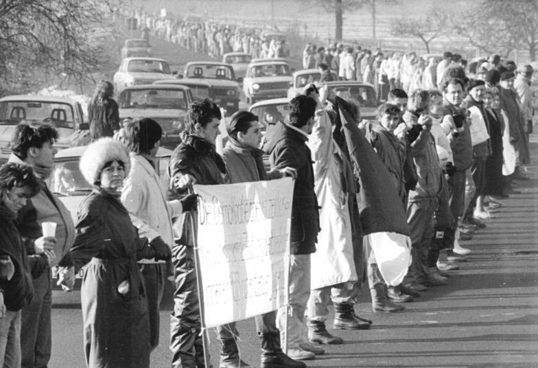
The Bundesstraße 71 (abbr: B 71) is one of the longer German federal roads numbered in the 60s and 70s series. It begins at the B 6 in Bremerhaven by the Unterweser and ends in Könnern near Halle (Saale) in Saxony-Anhalt. To begin with it is one of the east-west links across the Elbe-Weser Triangle and runs in a gentle curve via Bremervörde (48 km, briefly with the B 74) and Zeven (71 km) over the ''Hansa Line'' A 1 (83 km) to the district town of Rotenburg (Wümme) (97 km). Here it crosses the B 75 and continues past the Lüneburg Heath to Soltau (133 km), where it crosses the B 3. Carrying on towards the east it runs through heathland to Uelzen (190 km), where the road again crosses another major federal route, the B 4. Next it runs through the Elbufer-Drawehn Nature Park and crosses the old Inner German Border and present-day state border between Lower Saxony and Saxony-Anhalt at kilometre marker 222. I ... [...More Info...] [...Related Items...] OR: [Wikipedia] [Google] [Baidu] |
Bundesstraße 6
The Bundesstraße 6 (abbr. B6) is a German federal highway running from Bremerhaven on the North Sea coast in a southeasterly direction through the states of Lower Saxony, Bremen, Saxony-Anhalt and Saxony to Görlitz on the Polish border. History East of Leipzig, the B6 (except of the ring roads around Meißen, Dresden and Bischofswerda) largely follows the historic course of the '' Via Regia Lusatiae Superioris'', part of the medieval ''Via Regia''. In 1937, the northwestern section of the former ''Reichsstraße 6'' (R6) was extended from Bremerhaven (Wesermünde) to Cuxhaven. Before World War II and the implementation of the Oder–Neisse line, the R6 road continued southeastwards from Görlitz via Hirschberg (present-day Jelenia Góra, Poland) and Schweidnitz (Świdnica) to the Silesian capital Breslau (Wrocław) and from there via Oels (Oleśnica) as far as the former Polish border near Groß Wartenberg (Syców). The sections between Görlitz/Zgorzelec and Syc ... [...More Info...] [...Related Items...] OR: [Wikipedia] [Google] [Baidu] |
Uelzen
Uelzen (; officially the ''Hanseatic Town of Uelzen'', German: ''Hansestadt Uelzen'', , Low German ''Ülz’n'') is a town in northeast Lower Saxony, Germany, and capital of the county of Uelzen. It is part of the Hamburg Metropolitan Region, a Hanseatic town and an independent municipality. Uelzen is characterised by timber-framed architecture and also has some striking examples of North German brick Gothic. The county town earned pan-regional fame when Friedensreich Hundertwasser was selected to redesign the station: the final work of the celebrated Viennese artist and architect was ceremonially opened in 2000 as the Hundertwasser Station, Uelzen, and has since been a popular tourist magnet. The Polabian name for Uelzen is (spelled ''Wiltzaus'' in older German reference material), possibly derived from or (< Slavic *) 'alder'. Geography Loca ...
|
Magdeburg Ring
Magdeburg (; nds, label= Low Saxon, Meideborg ) is the capital and second-largest city of the German state Saxony-Anhalt. The city is situated at the Elbe river. Otto I, the first Holy Roman Emperor and founder of the Archdiocese of Magdeburg, was buried in the city's cathedral after his death. Magdeburg's version of German town law, known as Magdeburg rights, spread throughout Central and Eastern Europe. In the Late Middle Ages, Magdeburg was one of the largest and most prosperous German cities and a notable member of the Hanseatic League. One of the most notable people from the city is Otto von Guericke, famous for his experiments with the Magdeburg hemispheres. Magdeburg has been destroyed twice in its history. The Catholic League sacked Magdeburg in 1631, resulting in the death of 25,000 non-combatants, the largest loss of the Thirty Years' War. During the World War II the Allies bombed the city in 1945 and destroying much of it. After World War II the city belon ... [...More Info...] [...Related Items...] OR: [Wikipedia] [Google] [Baidu] |
Bundesstraße 1
The Bundesstraße 1 (abbr. B1) is a German federal highway running in an east-west direction from the Netherlands, Dutch border near Aachen to the Poland, Polish border at Küstrin-Kietz on the Oder River. History The road developed from an ancient east-western trade route connecting the shore of the North Sea at Bruges with the area of Veliky Novgorod, Novgorod. A trade and military road was already mentioned in Ptolemy's ''Geography (Ptolemy), Geography'' about 150 AD, parts of it formed the medieval Westphalian Hellweg trade route, vital for the transport of salt and crops, and the course of the Via Regia, the Ottonian dynasty, Ottonian "royal road" through the Holy Roman Empire from Aachen to Magdeburg. From the late 18th century onwards, parts of the route were rebuilt as a chaussee, mainly in the area between Aachen and Jülich as well as on the nearby territory of the County of Mark, promoted by the Brandenburg-Prussian administration under Heinrich Friedrich Karl vom und ... [...More Info...] [...Related Items...] OR: [Wikipedia] [Google] [Baidu] |
Bundesautobahn 2
is an autobahn in Germany that connects the Ruhr area in the west to Berlin in the east. The A 2 starts at the junction with the A3 near the western city of Oberhausen, passes through the north of the Ruhr valley, through the Münsterland and into Ostwestfalen, crossing the former inner German border and continuing through the Magdeburger Börde to merge into the Berliner Ring shortly before reaching Berlin. Major cities such as Magdeburg, Braunschweig, Hannover and Dortmund are situated very close to the A 2. The A 2 is one of the most important autobahns, connecting several large industrial areas with each other. The A 2 was modified in the late 1990s, and completely rebuilt in the former East Germany. All of the A 2 has 3 travel lanes and a breakdown lane in each direction. History The highway was planned between September 1933 and December 1934 by the construction departments of the company Reichsautobahn in Düsseldorf, Hanover and Merseburg. ... [...More Info...] [...Related Items...] OR: [Wikipedia] [Google] [Baidu] |
Bundesautobahn 14
is an autobahn in eastern Germany. The route comprises two disconnected sections: * The old A 241. A North-South route in Mecklenburg-Vorpommern which runs from Wismar to Schwerin. * The original A 14. A West-East route which starts at the A 2 near Magdeburg in Saxony-Anhalt and terminates at the A 4 at Dresden in Saxony. On the way, it serves Halle and Leipzig. Construction is underway to connect the two sections. Under construction * Lüderitz - Tangerhütte (Opening in 2023). Exit list (planned) (later Schwerin Schwerin (; Mecklenburgisch dialect, Mecklenburgian Low German: ''Swerin''; Latin: ''Suerina'', ''Suerinum'') is the Capital city, capital and List of cities and towns in Germany, second-largest city of the northeastern States of Germany, German ...-Mitte) , - , colspan="3", ---- , - , colspan="3", ---- , - , colspan="3", ---- , - , colspan="3", ---- ... [...More Info...] [...Related Items...] OR: [Wikipedia] [Google] [Baidu] |
Magdeburg
Magdeburg (; nds, label=Low Saxon, Meideborg ) is the capital and second-largest city of the German state Saxony-Anhalt. The city is situated at the Elbe river. Otto I, the first Holy Roman Emperor and founder of the Archdiocese of Magdeburg, was buried in the city's cathedral after his death. Magdeburg's version of German town law, known as Magdeburg rights, spread throughout Central and Eastern Europe. In the Late Middle Ages, Magdeburg was one of the largest and most prosperous German cities and a notable member of the Hanseatic League. One of the most notable people from the city is Otto von Guericke, famous for his experiments with the Magdeburg hemispheres. Magdeburg has been destroyed twice in its history. The Catholic League sacked Magdeburg in 1631, resulting in the death of 25,000 non-combatants, the largest loss of the Thirty Years' War. During the World War II the Allies bombed the city in 1945 and destroying much of it. After World War II the city belonged t ... [...More Info...] [...Related Items...] OR: [Wikipedia] [Google] [Baidu] |
Gardelegen
Gardelegen (; nds, Garlä) is a town in Saxony-Anhalt, Germany. It is situated on the right bank of the Milde, 20 m. W. from Stendal, on the main line of railway Berlin-Hanover. History Gardelegen has a Roman Catholic and three Evangelical churches, a hospital, founded in 1285, and a high-grade school. There are considerable manufactures, notably agricultural machinery and buttons, and its beer has a great reputation. Gardelegen was founded in the 10th century (first named 1196). The castle ''Isenschnibbe'' was owned by the House of Alvensleben from 1378 until 1857. On the neighboring heath Margrave Louis I. of Brandenburg gained, in 1343, a victory over Otto the Mild of Brunswick. In 1358 Gardelegen became a city of the Hanse. It suffered considerably in the Thirty Years' War, and in 1757 barely avoided being burned by the French. On 15 March 1945, 52 people lost their lives during an air raid, and on 13 April 1945, it was the site of a massacre of slave laborers, perpetrated ... [...More Info...] [...Related Items...] OR: [Wikipedia] [Google] [Baidu] |
Altmark
:''See German tanker Altmark for the ship named after Altmark and Stary Targ for the Polish village named Altmark in German.'' The (English: Old MarchHansard, ''The Parliamentary Debates from the Year 1803 to the Present Time ...'', Volume 32. 1 February to 6 March 1816, T.C. Hansard, 1816pp. 82 Article XXIII of the Final Act of the Congress of Vienna) is a historic region in Germany, comprising the northern third of Saxony-Anhalt. As the initial territory of the March of Brandenburg, it is sometimes referred to as the "Cradle of Prussia", as by Otto von Bismarck, a native from Schönhausen near Stendal. Geography The Altmark is located west of the Elbe river between the cities of Hamburg and Magdeburg, mostly included in the districts of Altmarkkreis Salzwedel and Stendal. In the west, the Drawehn hill range and the Drömling depression separate it from the Lüneburg Heath in Lower Saxony; the Altmark also borders the Wendland region in the north and the Magdeburg Börde in th ... [...More Info...] [...Related Items...] OR: [Wikipedia] [Google] [Baidu] |
Lüchow-Dannenberg
Lüchow-Dannenberg is a district in Lower Saxony, Germany, which is usually referred to as Hanoverian Wendland (''Hannoversches Wendland'') or Wendland. It is bounded by (from the west and clockwise) the districts of Uelzen and Lüneburg and the states of Mecklenburg-Western Pomerania (district of Ludwigslust-Parchim), Brandenburg (district of Prignitz) and Saxony-Anhalt (districts of Stendal and Altmarkkreis Salzwedel). History In medieval times the counties of Lüchow and Dannenberg occupied the area (from the early 12th century on). These counties were originally Slavic states that lost their independence to the Duchy of Brunswick-Lüneburg in the beginning of the 14th century. Since that time it was always an eastern extension of different entities, usually states like West Germany. The area was ruled by Lüneburg until 1705 and then became a part of the Electorate of Hanover. When the Kingdom of Hanover was annexed by Prussia (1866), the districts of Lüchow and Dannenber ... [...More Info...] [...Related Items...] OR: [Wikipedia] [Google] [Baidu] |
Salzwedel
Salzwedel (, officially known as Hansestadt Salzwedel; Low German: ''Soltwedel'') is a town in Saxony-Anhalt, Germany. It is the capital of the district (''Kreis'') of Altmarkkreis Salzwedel, and has a population of approximately 21,500. Salzwedel is located on the German Timber-Frame Road. Geography Salzwedel is situated at the river Jeetze in the northwestern part of the Altmark. It is located between Hamburg and Magdeburg. Distances from Uelzen are E, S of Lüchow, N of Gardelegen and W of Arendsee. In 1968 test drillings revealed a significant reservoir of natural gas near the city. Divisions The town Salzwedel consists of Salzwedel proper and the following ''Ortschaften'' or municipal divisions:Hauptsatzung der Hansestadt Salzwedel § 12, 24 October ... [...More Info...] [...Related Items...] OR: [Wikipedia] [Google] [Baidu] |

.jpg)


