|
Brugg
, neighboring_municipalities = Gebenstorf, Habsburg, Hausen, Holderbank, Lupfig, Riniken, Rüfenach, Schinznach, Untersiggenthal, Villigen, Villnachern, Veltheim, Windisch , twintowns = Rottweil (Germany) , website = www.stadt-brugg.ch Brugg (sometimes written as Brugg AG in order to distinguish it from other ''Brugg''s) is a Swiss municipality and a town in the canton of Aargau and is the seat of the district of the same name. The town is located at the confluence of the Aare, Reuss, and Limmat, with the Aare flowing through its medieval part. It is located approximately from the cantonal capital of Aarau; from Zürich; and about from Basel. Brugg is the Swiss German term for bridge (german: Brücke). This is an allusion to the purpose of the medieval town's establishment under the Habsburgs, as the town is located at the narrowest point on the Aare in the Swiss midlands. The Habsburgs’ oldest known residence is located in the ne ... [...More Info...] [...Related Items...] OR: [Wikipedia] [Google] [Baidu] |
Brugg (district)
Brugg District is a district in the Canton of Aargau, Switzerland. The capital of the district is the town of Brugg, Switzerland, Brugg. Geography Brugg District has an area, , of . Of this area, 42.6% is used for agricultural purposes, while 41.3% is forested. The rest of the land, (14.1%) is settled. It is located around the rivers Aare and Reuss (river), Reuss. The northern part of the district, north of the Aare, lies in the Aargau part of the Jura mountains. Demographics Brugg District has a population () of 46,471.Statistical Department of Canton Aargau -Bereich 01 -Bevölkerung accessed 20 January 2010 , there were 1,635 homes with 1 or 2 persons in the household, 8,736 homes with 3 or 4 persons in the household, and 6,792 homes with 5 or more persons in the household. The average number of pe ... [...More Info...] [...Related Items...] OR: [Wikipedia] [Google] [Baidu] |
Hausen, Aargau
Hausen (prior to 2003: Hausen bei Brugg) is a municipality in the district of Brugg in canton of Aargau in Switzerland. History Iron Age graves near Hausen indicate that the area has a long history. The current village is built over a Roman era town, of which the remains of buildings, roads and water lines (including one that is still in operation) are still visible. Modern Hausen is first mentioned in 1254 as ''Husen''. Hausen was part of the original Habsburg lands (german: Eigenamt). Religiously it was part of the parish of Windisch until 1978 when the village built its own Reformed Church. Economically, agriculture (especially vineyards) dominated. Though since the 18th Century, the textile industry has also been important in the village. During the Middle Ages limestone was quarried and in the 2nd half of the 19th Century clay was mined. A bus service to Hausen has existed since 1955. After about 1950 the a strong housing industry led to population growth. With th ... [...More Info...] [...Related Items...] OR: [Wikipedia] [Google] [Baidu] |
Canton Of Aargau
Aargau, more formally the Canton of Aargau (german: Kanton Aargau; rm, Chantun Argovia; french: Canton d'Argovie; it, Canton Argovia), is one of the 26 cantons forming the Swiss Confederation. It is composed of eleven districts and its capital is Aarau. Aargau is one of the most northerly cantons of Switzerland. It is situated by the lower course of the Aare River, which is why the canton is called ''Aar- gau'' (meaning "Aare province"). It is one of the most densely populated regions of Switzerland. History Early history The area of Aargau and the surrounding areas were controlled by the Helvetians, a member of the Celts, as far back as 200 BC. It was eventually occupied by the Romans and then by the 6th century, the Franks. The Romans built a major settlement called Vindonissa, near the present location of Brugg. Medieval Aargau The reconstructed Old High German name of Aargau is ''Argowe'', first unambiguously attested (in the spelling ''Argue'') in 795. The term ... [...More Info...] [...Related Items...] OR: [Wikipedia] [Google] [Baidu] |
Windisch, Switzerland
Windisch is a municipality in the district of Brugg in the canton of Aargau in Switzerland. Etymology Windisch is situated at the site of the Roman legion camp Vindonissa. Originally a Celtic God, the name ''Vindos'' points to a widespread prehistorical cult of Vindos and the most likely origin of the ''Windisch'' place name. In 1064 the current municipality was mentioned as ''Vinse'', and in 1175 as ''Vindisse''. Until the 19th Century the official name was ''Windisch und Oberburg''. History Windisch grew into a regional power following the foundation of Königsfelden Abbey in 1309 in memory of the regicide of King Albert I of Germany in the previous year. Albert was on the way to suppress a revolt in Swabia when he was murdered on May 1, 1308, near Windisch on the Reuss, by his nephew John of Swabi, afterwards called "the Parricide" or "John Parricida", whom he had deprived of his inheritance. After the foundation of the Abbey, the village was placed under the authori ... [...More Info...] [...Related Items...] OR: [Wikipedia] [Google] [Baidu] |
Habsburg, Switzerland
Habsburg (High Alemannic: ''Hapschberg'') is a municipality in the district of Brugg in canton of Aargau in Switzerland. It lies about three kilometres southwest of the town of Brugg, the capital of the district of Brugg. Habsburg is named after Habsburg Castle, built around 1020-1030 for Count Radbot of the nearby county of Klettgau in the Duchy of Swabia, which Habsburg was also a part of at the time. History While Bronze Age and Roman era artifacts have been discovered, a village named Habsburg isn't mentioned until 1027, as ''Habesbur'' or ''Habeburch''. This reference comes from a later (1114) copy of the original 1027 document. In 1114 it was mentioned ''Hauesborc''. The documentation of the village in 1027 is contemporary with Count Radbot's construction of Habsburg Castle. It is believed that they named the castle after a hawk (german: Habicht) seen sitting on its walls. Some historians and linguists believe the name may come from the Middle High German word 'hab ... [...More Info...] [...Related Items...] OR: [Wikipedia] [Google] [Baidu] |
Rüfenach
Rüfenach is a municipality in the district of Brugg in the canton of Aargau in Switzerland. Geography The municipality lies at the foot of the Bruggerberg and the Reinerberg, the southeast foothills of the Jura Mountains. It consists of three villages, Rüfenach, Hinterrein, and Vorderrein. The latter two were part of an independent municipality called Rein until 1898.. Rüfenach lies furthest west in the middle of a flat plain. Hinterrein is slightly higher and lies in the middle. Vorderrein is to the east on a marked hill. The east side of this hill falls sharply to the Aare. The difference in altitude is about . Rüfenach has an area, , of . Of this area, or 47.5% is used for agricultural purposes, while or 40.8% is forested. Of the rest of the land, or 11.5% is settled (buildings or roads), or 0.5% is either rivers or lakes. [...More Info...] [...Related Items...] OR: [Wikipedia] [Google] [Baidu] |
Riniken
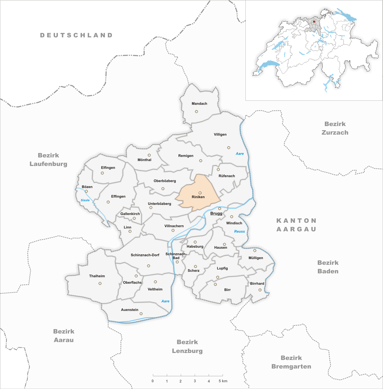
Riniken is a municipality in the district of Brugg in the canton of Aargau in Switzerland. History While Iberg Castle was built in the 11th Century and abandoned in 1200, the village of Riniken is first mentioned in 1253 as ''Rinikon''. The rights to high justice were held by the Habsburgs until 1460, when the rights went to the bailiwick of Schenkenberg under the city of Bern. The low justice right was held, until 1406, by Königsfelden Abbey and after the Protestant Reformation those rights transferred to Bözberg. Religiously, Riniken belonged to the Umiken parish. In 1967 the village received a private cemetery, and in 1978 an ecumenical ecclesiastical center. Starting in 1712, there was a migration of villagers to Dättwil (now part of Baden), as agriculture offered very little money. There was never any industry in Riniken, but in 1960 about half of the workforce worked in the second sector. The recent population growth is mainly due to commuters who have moved in ... [...More Info...] [...Related Items...] OR: [Wikipedia] [Google] [Baidu] |
List Of Towns In Switzerland
Below is a list of towns and cities in Switzerland. Until 2014 municipalities with more than 10,000 inhabitants were considered to be towns (german: Stadt/Städte, french: ville(s), it, città). Since 2014, the Federal Statistical Office (FSO) uses a new algorithm (called german: Statistische Städte 2012, or french: Villes statistiques 2012) to define whether a municipality can be called a town or not; it now also depends on its character. Currently, FSO considers 162 municipalities as towns/cities (german: Statistische Städte, french: Villes statistiques) in Switzerland. Further, some municipalities which would fulfill such a definition nevertheless prefer to understand themselves still as a village, or consequently refer to themselves just as municipalities (german: Gemeinde, french: commune, it, comune). The Swiss definition of a town differs from the definition of a municipality. List of towns and cities This is an alphabetical list of towns or cities (these English term ... [...More Info...] [...Related Items...] OR: [Wikipedia] [Google] [Baidu] |
Umiken
Umiken was a municipality in the district of Brugg in the canton of Aargau in Switzerland. On 1 January 2010 the municipality of Umiken merged into Brugg , neighboring_municipalities = Gebenstorf, Habsburg, Hausen, Holderbank, Lupfig, Riniken, Rüfenach, Schinznach, Untersiggenthal, Villigen, Villnachern, Veltheim, Windisch , twintowns = Rottweil (Germany) , website .... Economy there was a total of 525 workers who lived in the municipality. Of these, 472 or about 89.9% of the residents worked outside Umiken while 45 people commuted into the municipality for work. There were a total of 98 jobs (of at least 6 hours per week) in the municipality. accessed 21 January 2010 Refe ...
|
Villigen
Villigen is a Municipalities of Switzerland, municipality in the district of Brugg (district), Brugg in the Cantons of Switzerland, canton of Aargau in Switzerland. In January 2006, Villigen incorporated the former municipality of Stilli. The Paul Scherrer Institute is primarily located in Villigen, although part is across the Aare river in Würenlingen. Geography Villigen has an area, , of . Of this area, or 34.6% is used for agricultural purposes, while or 49.0% is forested. Of the rest of the land, or 13.5% is settled (buildings or roads), or 2.8% is either rivers or lakes.Swiss Federal Statistical Office-Land Use Statistics 2009 data accessed 25 March 2010 Of the built up area, housing and buildings made up 5.7% and transportation infrastructu ... [...More Info...] [...Related Items...] OR: [Wikipedia] [Google] [Baidu] |
Villnachern
Villnachern is a municipality in the district of Brugg in the canton of Aargau in Switzerland. Geography Villnachern has an area, , of . Of this area, or 29.1% is used for agricultural purposes, while or 49.7% is forested. Of the rest of the land, or 12.5% is settled (buildings or roads), or 7.0% is either rivers or lakes and or 0.7% is unproductive land.Swiss Federal Statistical Office-Land Use Statistics 2009 data accessed 25 March 2010 Of the built up area, housing and buildings made up 7.8% and transportation infrastructure made up 4.2%. 46.9% of the total land area is heavily forested and 2.8% is covered with orchards or small clusters of trees. Of the agricultural land, 17.1% is used for growing crops and 9.2% is pastures, while 2.8% is ... [...More Info...] [...Related Items...] OR: [Wikipedia] [Google] [Baidu] |
Lupfig
Lupfig is a municipality in the district of Brugg in canton of Aargau in Switzerland. On 1 January 2018 the former municipality of Scherz merged into the municipality of Lupfig. History Near the modern village of Lupfig was the source of a Roman aqueduct leading to the camp of Vindonissa. Additionally, Alamanni graves have been discovered near the village. The modern village of Lupfig is first mentioned about 1273 as ''Lupfanch''. The village was part of the Habsburgs core possessions (german: Eigenamt) and is near Habsburg Castle. In the 14th Century, the rights to the low justice and property in the village went to Königsfelden Abbey. When the abbey was dissolved, the property went to the city of Bern. The municipality has owned a tavern since at least 1628. Until 1526 it was part of the Windisch parish, then it went to the Birr parish and in 1715 Lupfig had its own parsonage. Since 1966 the village has had a Catholic chapel of ease. While agriculture was the main ... [...More Info...] [...Related Items...] OR: [Wikipedia] [Google] [Baidu] |


