|
Brownsville, Arkansas
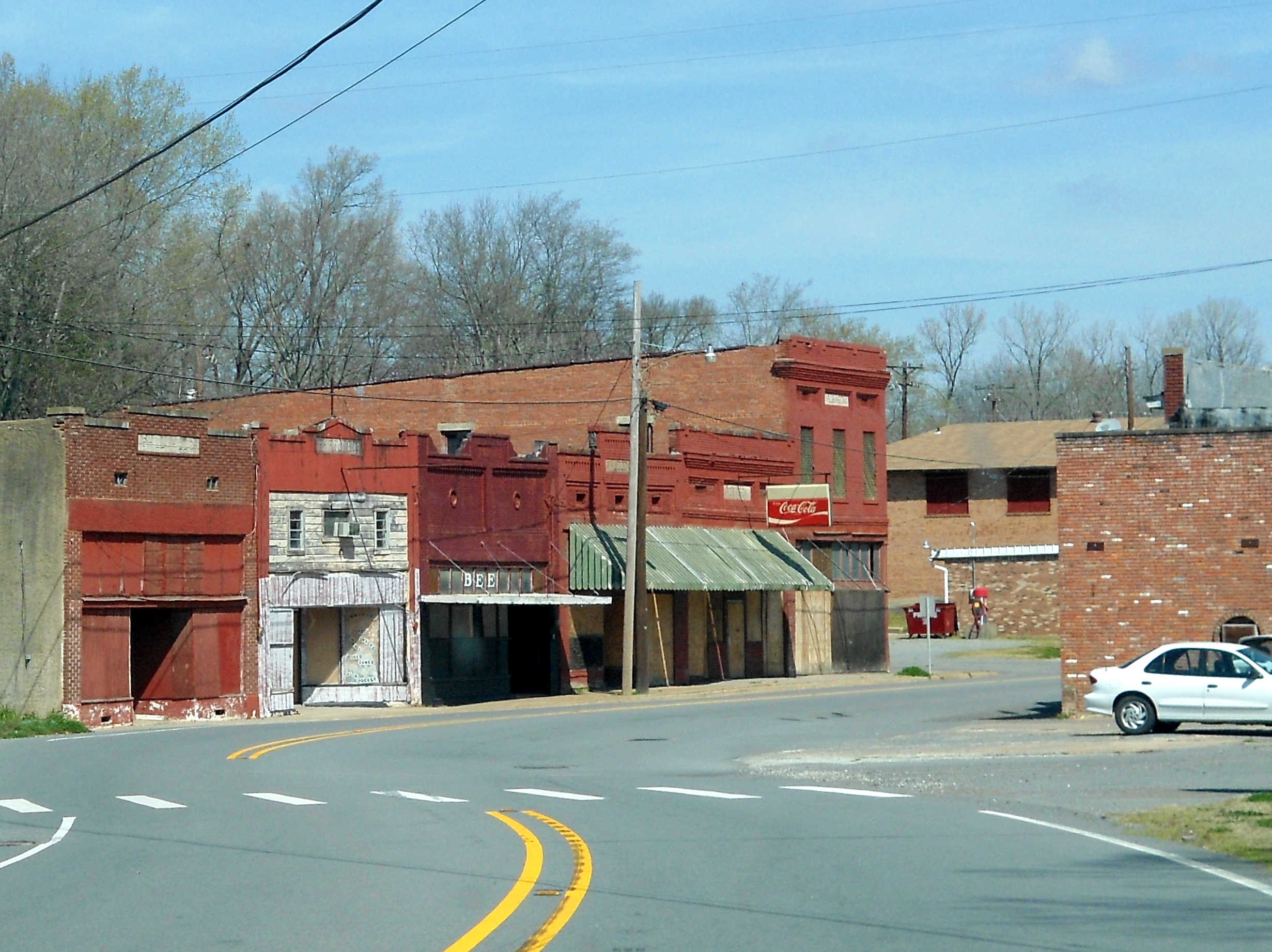
Brownsville is an unincorporated area, unincorporated community in Lonoke County, Arkansas, Lonoke County, Arkansas, United States. The community is on Arkansas Highway 31 north-northeast of Lonoke, Arkansas, Lonoke. Brownsville was established in 1846 in what was at the time part of Prairie County, Arkansas, Prairie County, and it served as the first county seat. The community was named for U.S. Army officer Jacob Brown (Texas soldier), Jacob Brown, who was killed in the Siege of Fort Texas the same year. By 1860, the town's population had grown to 2,000 residents, and it had a courthouse, a hotel, a newspaper, and several churches and businesses. During the American Civil War, a Battle of Brownsville, Arkansas, battle and multiple smaller skirmishes were fought at Brownsville, and soldiers from both sides plundered resources from the town. After the war, the Memphis and Little Rock Railroad bypassed the town to the south, and Prairie County moved its seat to DeValls Bluff, Arkan ... [...More Info...] [...Related Items...] OR: [Wikipedia] [Google] [Baidu] |
Unincorporated Area
An unincorporated area is a region that is not governed by a local municipal corporation. Widespread unincorporated communities and areas are a distinguishing feature of the United States and Canada. Most other countries of the world either have no unincorporated areas at all or these are very rare: typically remote, outlying, sparsely populated or List of uninhabited regions, uninhabited areas. By country Argentina In Argentina, the provinces of Chubut Province, Chubut, Córdoba Province (Argentina), Córdoba, Entre Ríos Province, Entre Ríos, Formosa Province, Formosa, Neuquén Province, Neuquén, Río Negro Province, Río Negro, San Luis Province, San Luis, Santa Cruz Province, Argentina, Santa Cruz, Santiago del Estero Province, Santiago del Estero, Tierra del Fuego Province, Argentina, Tierra del Fuego, and Tucumán Province, Tucumán have areas that are outside any municipality or commune. Australia Unlike many other countries, Australia has only local government in Aus ... [...More Info...] [...Related Items...] OR: [Wikipedia] [Google] [Baidu] |
Arkansas Department Of Transportation
The Arkansas Department of Transportation (ArDOT), formerly the Arkansas Highway and Transportation Department, is a government department in the U.S. state of Arkansas. Its mission is to provide a safe, efficient, aesthetically pleasing and environmentally sound intermodal transportation system for the user. The department is responsible for implementing policy made by the Arkansas State Highway Commission, a board of officials appointed by the Governor of Arkansas to direct transportation policy in the state. The department's director is appointed by the commission to hire staff and manage construction and maintenance on Arkansas's highways. The primary duty of ArDOT is the maintenance and management of the over Arkansas Highway System. The department also conducts planning, public transportation, the State Aid County Road Program, the Arkansas Highway Police, and Federal-Aid project administration. Its headquarters are in Little Rock. History Central control of highway tr ... [...More Info...] [...Related Items...] OR: [Wikipedia] [Google] [Baidu] |
DeValls Bluff, Arkansas
DeValls Bluff is a city in and the county seat of the southern district of Prairie County, Arkansas, United States. The population was 619 at the 2010 census. History Prairie County has always been important to Arkansas for the transportation of people and goods throughout the state. Initially, it was the White River that gave the agricultural county its importance for transport, since waterways were the primary means of long-distance transportation in the period before the development of railroads. Prairie County was cut from Arkansas, Pulaski, Monroe, St. Francis, and White counties in 1846 and included present-day Lonoke County. European settlement in Prairie County came in the 19th century, with Jacob M. DeVall and his son, Chappel, becoming the first recorded settlers around DeValls Bluff according to 1851 tax records. During the Civil War, the city was a trading center on the White River, which continued to be the primary shipping corridor when the Arkansas River was i ... [...More Info...] [...Related Items...] OR: [Wikipedia] [Google] [Baidu] |
Memphis And Little Rock Railroad
The Memphis and Little Rock Railroad was chartered in the U.S. state of Arkansas in 1853. The line ran from Hopefield, Arkansas (now West Memphis) on the east, to Huntersville (now North Little Rock, Arkansas) on the west. The eastern third was completed in 1858 and the western third was built by 1862. During the American Civil War, the Union Army seized control of the line and used the western section to supply its occupation force in Little Rock. The center section was finally completed in 1871. The railroad was subjected to frequent damage from floods and suffered from financial problems. It was sold in 1873, 1877, 1887, 1898, and 1900 before eventually becoming part of the Chicago, Rock Island and Pacific Railroad (Rock Island). Pre-war The Memphis and Little Rock Railroad (M&LR) was chartered by the State of Arkansas on January 10, 1853. Construction of the gauge railroad was estimated to cost $3.2 million. John H. Bradley & Company won the contract to build the line. The s ... [...More Info...] [...Related Items...] OR: [Wikipedia] [Google] [Baidu] |
Battle Of Brownsville, Arkansas
The Battle of Brownsville was fought on August 25, 1863, near what is now Lonoke, Arkansas, between Union forces led by Colonel Washington Geiger and Confederate troops under Brigadier General John S. Marmaduke. Union forces commanded by Major General Frederick Steele were advancing from Helena, Arkansas, towards Little Rock, the state capital of Arkansas. Confederate Major General Sterling Price ordered cavalry led by Marmaduke and Brigadier General Lucius M. Walker to Brownsville in response to the Union advance. Marmaduke's men defended a forward position, while Walker's remained to the rear in some woods; the plan was for Marmaduke to draw Union troops into an ambush. However, Walker did not come to Marmaduke's aid when a Union brigade commanded by Geiger advanced. Geiger's men drove the outnumbered Confederates from their first position. Reforming, Marmaduke attempted to form another line further to the west, but retreated again after delaying the Union advance. Union troops ... [...More Info...] [...Related Items...] OR: [Wikipedia] [Google] [Baidu] |
American Civil War
The American Civil War (April 12, 1861 – May 26, 1865; also known by other names) was a civil war in the United States. It was fought between the Union ("the North") and the Confederacy ("the South"), the latter formed by states that had seceded. The central cause of the war was the dispute over whether slavery would be permitted to expand into the western territories, leading to more slave states, or be prevented from doing so, which was widely believed would place slavery on a course of ultimate extinction. Decades of political controversy over slavery were brought to a head by the victory in the 1860 U.S. presidential election of Abraham Lincoln, who opposed slavery's expansion into the west. An initial seven southern slave states responded to Lincoln's victory by seceding from the United States and, in 1861, forming the Confederacy. The Confederacy seized U.S. forts and other federal assets within their borders. Led by Confederate President Jefferson Davis, ... [...More Info...] [...Related Items...] OR: [Wikipedia] [Google] [Baidu] |
Siege Of Fort Texas
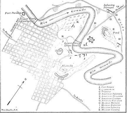
The siege of Fort Texas marked the beginning of active campaigning by the armies of the United States and Mexico during the Mexican–American War. The battle is sometimes called the siege of Fort Brown. Major Jacob Brown, not to be confused with War of 1812 General Jacob Brown, was one of the two Americans killed in action. Background On 28 March 1846, the Army of Occupation under General Zachary Taylor reached the north bank of the Rio Grande. Taylor ordered Captain Joseph K. Mansfield to construct an earthen star fort for 800 men named "Fort Texas".Bauer, K.J., ''The Mexican War, 1846–1848'', New York: Mcmillan, The fort was garrisoned by 500 men under Major Jacob Brown, including the 7th Infantry, Capt. Allen Lowd's four 18-pounders, and Lt. Braxton Bragg's field battery. Mexican General Francisco Mejia's 2,000 men also erected similar fortifications, including for his twenty cannons, for 800 men upstream at the Las Anacuitas ferry crossing, called Fort Paredes; an ... [...More Info...] [...Related Items...] OR: [Wikipedia] [Google] [Baidu] |
Jacob Brown (Texas Soldier)
Jacob Brown (July 19, 1789 – May 9, 1846) was an American Army officer and commander of the U.S. 7th Infantry during the Mexican-American War. Brown was mortally wounded on May 6, 1846 while leading American forces at the Siege of Fort Texas near Brownsville, Texas. Brown was born in Massachusetts and enlisted in the Eleventh United States Infantry on August 3, 1812. He commissionned as an ensign in the Eleventh Infantry on April 15, 1814. On May 17 , 1815, Brown transferred to the Sixth Infantry where he served as regimental quartermaster from April 16 to June 1, 1821. Fort Texas was renamed Fort Brown in his honor with the city of Brownsville, TX Brownsville () is a city in Cameron County in the U.S. state of Texas. It is on the western Gulf Coast in South Texas, adjacent to the border with Matamoros, Mexico. The city covers , and has a population of 186,738 as of the 2020 census. It ... deriving its name from the fort. Promotions References External links * ... [...More Info...] [...Related Items...] OR: [Wikipedia] [Google] [Baidu] |
Prairie County, Arkansas
Prairie County is in the Central Arkansas region of the U.S. state of Arkansas. The county is named for the Grand Prairie, a subregion of the Arkansas Delta known for rice cultivation and aquaculture that runs through the county. Created as Arkansas's 54th county in 1846, Prairie County is home to four incorporated towns, including DeValls Bluff, the southern district county seat, and two incorporated cities, including Des Arc, the northern district county seat. The county is also the site of numerous unincorporated communities and ghost towns. Occupying , Prairie County is the median-sized county in Arkansas. As of the 2010 Census, the county's population is 8,715 people in 4,503 households. Based on population, the county is the ninth-smallest county of the 75 in Arkansas. The county is crossed by Interstate 40 (I-40), a major east–west Interstate highway running from California to North Carolina, as well as four United States highways ( U.S. Route 63 S 63 US 70, US 79, a ... [...More Info...] [...Related Items...] OR: [Wikipedia] [Google] [Baidu] |
Lonoke, Arkansas
Lonoke () is the second most populous city in Lonoke County, Arkansas, United States, and serves as its county seat. According to 2010 United States Census, the population of the city is 4,245. It is part of the Little Rock–North Little Rock– Conway Metropolitan Statistical Area. History Lonoke's history begins with the advance of Union troops through Central Arkansas during the American Civil War. The town of Brownsville was burned to the ground by Union forces after the retreat of Confederate forces westward to Little Rock. After the war, it was decided by the city leaders of Brownsville that a new town should be formed by the nearby railroad so that those who wished to stay could do so. According to local legend, the town was named for a large red oak tree that was found while trees were being chopped down in order to build houses. The official name of the city was originally Lone Oak. However, due to a misprint in the ''Lonoke Democrat'' newspaper, the town' ... [...More Info...] [...Related Items...] OR: [Wikipedia] [Google] [Baidu] |
List Of Sovereign States
The following is a list providing an overview of sovereign states around the world with information on their status and recognition of their sovereignty. The 206 listed states can be divided into three categories based on membership within the United Nations System: 193 UN member states, 2 UN General Assembly non-member observer states, and 11 other states. The ''sovereignty dispute'' column indicates states having undisputed sovereignty (188 states, of which there are 187 UN member states and 1 UN General Assembly non-member observer state), states having disputed sovereignty (16 states, of which there are 6 UN member states, 1 UN General Assembly non-member observer state, and 9 de facto states), and states having a special political status (2 states, both in free association with New Zealand). Compiling a list such as this can be a complicated and controversial process, as there is no definition that is binding on all the members of the community of nations concerni ... [...More Info...] [...Related Items...] OR: [Wikipedia] [Google] [Baidu] |
Arkansas Highway 31
Highway 31 (AR 31, Ark. 31 and Hwy. 31) is a north–south state highway in Central Arkansas. The route of runs from U.S. Route 79B (US 79B) near Pine Bluff north across US 165, US 70, Interstate 40 (I-40) and US 64/US 67/US 167 (Future Interstate 57 ) before terminating at Highway 5 near Romance. Route description The highway begins north of Pine Bluff at US 79B and runs north to intersect Highway 15 near Sherrill. Continuing north of this junction Highway 31 passes the Tucker Unit and passes through farm fields before it enters Lonoke County. The route passes the Walls Farm Barn and Corn Crib, listed on the National Register of Historic Places (NRHP) north of Tomberlin before it has a short concurrency with US 165 through Coy (a rare officially designated exception). Highway 31 continues north through farmland, intersecting Highway 232 at Blakemore before forming a concurrency with US 70 south of Lonoke. The US 70/AR 31 overlap continues into ... [...More Info...] [...Related Items...] OR: [Wikipedia] [Google] [Baidu] |


