|
British Columbia Highway 62
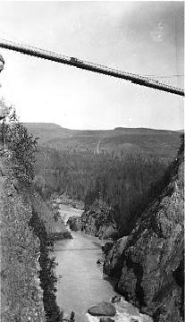
Highway 62, also known as ''High Level Road'', is a spur located in northern British Columbia, running from the junction of the Yellowhead Highway (Highway 16) in New Hazelton to downtown Hazelton. Highway 62 is an unofficial highway. After leaving New Hazelton, the highway crosses the Hagwilget First Nations reserve community. Continuing west, Highway 62 passes over the Bulkley River The Bulkley River in British Columbia is a major tributary of the Skeena River. The Bulkley is long with a drainage basin covering . Much of the Bulkey is paralleled by Highway 16. It flows west from Bulkley Lake past Perow and is joined near ... and through the village of Two Mile before ending on River Road in Hazelton. References {{BritishColumbia-road-stub 62 ... [...More Info...] [...Related Items...] OR: [Wikipedia] [Google] [Baidu] |
Hazelton, British Columbia
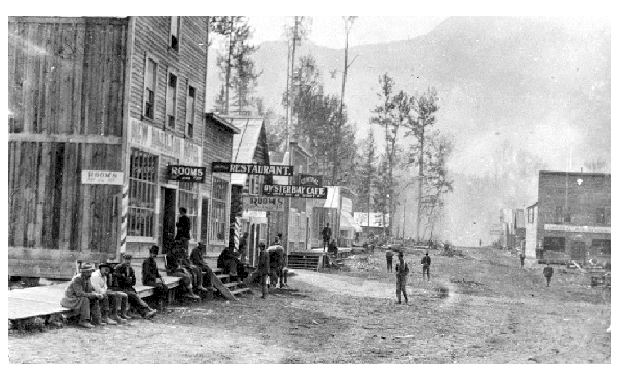
Hazelton is a village located at the junction of the Bulkley and Skeena Rivers in northern British Columbia, Canada. It was founded in 1866 and in 2011 had a population of 305. The nearby larger community of New Hazelton is the northernmost point of the Yellowhead Highway, a major interprovincial highway which runs from Prince Rupert, British Columbia, to Portage la Prairie, Manitoba. The Hazelton area comprises two municipalities (the Village of Hazelton and District of New Hazelton), three unincorporated settlements (South Hazelton, Two Mile and the Kispiox Valley), four First Nations’ villages: three of which are of the Gitxsan people (Gitanmaax, Glen Vowell and Kispiox) and A Wetʼsuwetʼen people, the Hagwilget. First Nations history The Hazeltons are home to the Gitxsan and Wet'suwet'en First Nations. Old Hazelton and Two Mile Hazelton is one of the oldest settlements in northern British Columbia; its European settlement dates back to 1866 when the Collins Overlan ... [...More Info...] [...Related Items...] OR: [Wikipedia] [Google] [Baidu] |
New Hazelton, British Columbia
New Hazelton is a district municipality on Highway 16 in northwest British Columbia, Canada. It is situated northeast of Terrace and northwest of Smithers and in 2016 had a population of 580 people, a decrease of 12.9% comparing to 2011. New Hazelton is one of the "Three Hazeltons", the other two being the original "Old" Hazelton located to the northwest very near to the confluence of the Skeena and Bulkley Rivers and South Hazelton, to the west. Demographics In the 2021 Census of Population conducted by Statistics Canada, New Hazelton had a population of 602 living in 266 of its 305 total private dwellings, a change of from its 2016 population of 580. With a land area of , it had a population density of in 2021. Economy New Hazelton is the service and commerce center for the Kispiox Valley, which includes several first nation communities as well as residents of South Hazelton and Old Hazelton. The population of this area is approximately 6500 people. Due to its lo ... [...More Info...] [...Related Items...] OR: [Wikipedia] [Google] [Baidu] |
Spur Route
A spur route is a short road forming a branch from a longer, more important road such as a freeway, Interstate Highway, or motorway. A bypass or beltway should not be considered a true spur route as it typically reconnects with another or the same major road. Canada In the province of Ontario, most spur routes are designated as A or B, such as Highway 17A, or 7B. A stands for "Alternate Route", and usually links a highway to a town's central core or main attraction, while B stands for "Business Route" or "Bypass", but are used when a main highway is routed around a town and away from its former alignment. The designation of "C" was used twice (Highway 3C and 40C), and is assumed to mean "Connector". Both highways have long since been retired and are now county roads. There was also one road with the D designation (Highway 8D, later the original Highway 102), and this may have stood for "Diversion", as it was along the first completed divided highway in Canada at the time (Coo ... [...More Info...] [...Related Items...] OR: [Wikipedia] [Google] [Baidu] |
British Columbia
British Columbia (commonly abbreviated as BC) is the westernmost province of Canada, situated between the Pacific Ocean and the Rocky Mountains. It has a diverse geography, with rugged landscapes that include rocky coastlines, sandy beaches, forests, lakes, mountains, inland deserts and grassy plains, and borders the province of Alberta to the east and the Yukon and Northwest Territories to the north. With an estimated population of 5.3million as of 2022, it is Canada's third-most populous province. The capital of British Columbia is Victoria and its largest city is Vancouver. Vancouver is the third-largest metropolitan area in Canada; the 2021 census recorded 2.6million people in Metro Vancouver. The first known human inhabitants of the area settled in British Columbia at least 10,000 years ago. Such groups include the Coast Salish, Tsilhqotʼin, and Haida peoples, among many others. One of the earliest British settlements in the area was Fort Victoria, established ... [...More Info...] [...Related Items...] OR: [Wikipedia] [Google] [Baidu] |
Yellowhead Highway
The Yellowhead Highway (french: Route Yellowhead) is a major interprovincial highway in Western Canada that runs from Winnipeg to Graham Island off the coast of British Columbia via Saskatoon and Edmonton. It stretches across the four western Canadian provinces of British Columbia, Alberta, Saskatchewan, and Manitoba and is part of the Trans-Canada Highway system and the larger National Highway System, but should not be confused with the more southerly, originally-designated Trans-Canada Highway. The highway was officially opened in 1970. Beginning in 1990, the green and white Trans-Canada logo was used to designate the roadway. The highway is named for the Yellowhead Pass, the route chosen to cross the Canadian Rockies. The pass and the highway are named after a fur trader and explorer named Pierre Bostonais. He had yellow streaks in his hair, and was nicknamed "Tête Jaune" (Yellowhead). Almost the entire length of the highway is numbered as 16, except for the section in ... [...More Info...] [...Related Items...] OR: [Wikipedia] [Google] [Baidu] |
British Columbia Highway 16
Highway 16 is a highway in British Columbia, Canada. It is an important section of the Yellowhead Highway, a part of the Trans-Canada Highway that runs across Western Canada. The highway closely follows the path of the northern B.C. alignment of the Canadian National Railway. The number "16" was first given to the highway in 1941, and originally, the route that the highway took was more to the north of today's highway, and it was not as long as it is now. Highway 16 originally ran from New Hazelton east to Aleza Lake. In 1947, Highway 16's western end was moved from New Hazelton to the coastal city of Prince Rupert, and in 1953, the highway was re-aligned to end at Prince George. In 1969, further alignment east into Yellowhead Pass was opened to traffic after being constructed up through 1968 and raised to all-weather standards in 1969. Highway 16's alignment on Haida Gwaii was commissioned in 1983 and is connected to the mainland segment via BC Ferries route #11. A series of ... [...More Info...] [...Related Items...] OR: [Wikipedia] [Google] [Baidu] |
New Hazelton
New Hazelton is a district municipality on Highway 16 in northwest British Columbia, Canada. It is situated northeast of Terrace and northwest of Smithers and in 2016 had a population of 580 people, a decrease of 12.9% comparing to 2011. New Hazelton is one of the "Three Hazeltons", the other two being the original "Old" Hazelton located to the northwest very near to the confluence of the Skeena and Bulkley Rivers and South Hazelton, to the west. Demographics In the 2021 Census of Population conducted by Statistics Canada, New Hazelton had a population of 602 living in 266 of its 305 total private dwellings, a change of from its 2016 population of 580. With a land area of , it had a population density of in 2021. Economy New Hazelton is the service and commerce center for the Kispiox Valley, which includes several first nation communities as well as residents of South Hazelton and Old Hazelton. The population of this area is approximately 6500 people. Due to its l ... [...More Info...] [...Related Items...] OR: [Wikipedia] [Google] [Baidu] |
Hagwilget Village First Nation
The Hagwilget Village First Nation is a First Nations band government of the Wet'suwet'en subgroup of the Dakelh (Carrier) people, located at Hagwilget, British Columbia, Canada, which is just east of Hazelton, British Columbia. The band is one of the 13 member governments of the Hereditary Chiefs of the Wet'suwet'en, which functions as a tribal council (but is a traditional government) in alliance with the 35 members of the Hereditary Chiefs of the Gitxsan Gitxsan (also spelled Gitksan) are an Indigenous people in Canada whose home territory comprises most of the area known as the Skeena Country in English (: means "people of" and : means "the River of Mist"). Gitksan territory encompasses approxim .... re [...More Info...] [...Related Items...] OR: [Wikipedia] [Google] [Baidu] |
Bulkley River
The Bulkley River in British Columbia is a major tributary of the Skeena River. The Bulkley is long with a drainage basin covering . Much of the Bulkey is paralleled by Highway 16. It flows west from Bulkley Lake past Perow and is joined near Houston by the Morice River, its major tributary. The Bulkley continues north past Quick, Telkwa and Smithers. It then meets the Skeena River near Hazelton. The Bulkley River is a major tourist destination for anglers targeting wild steelhead.http://www.env.gov.bc.ca/skeena/fish/AMPs/Bulkley_AMP.pdf The river was originally called ''Wet'sinkwha'' ("blue and green river") by the Wet'suwet'en people, the indigenous inhabitants of the Bulkley Valley. The name Bulkley was given for Colonel Charles S. Bulkley, the U.S. Army engineer-in-charge of the survey team who, in 1866, explored the area in preparation for the failed Russian American Telegraph. The project was abandoned because of the success of the trans-Atlantic cable in 1866. The L ... [...More Info...] [...Related Items...] OR: [Wikipedia] [Google] [Baidu] |


