|
Brea Hill, Trebetherick
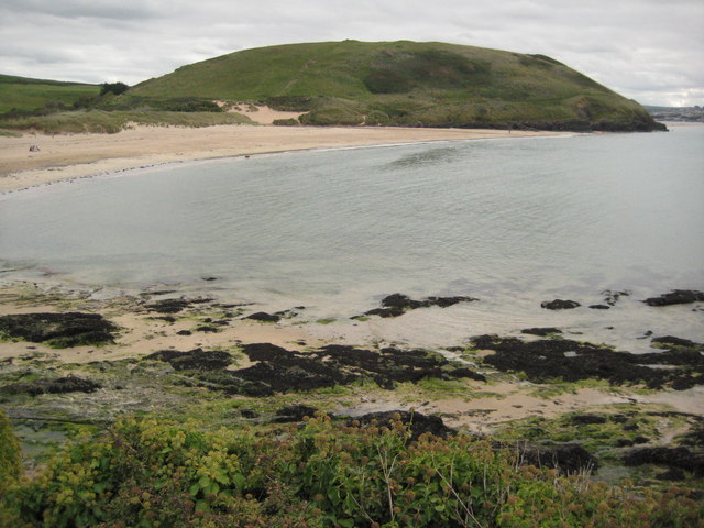
Brea Hill ( kw, Bre, meaning ''hill''), pronounced "Bray Hill" is a round hill beside the River Camel estuary in north Cornwall, England, United KingdomOrdnance Survey: Landranger map sheet 200 ''Newquay & Bodmin'' The hill is highOrdnance Survey: Explorer map (scale 1:25000); Sheet 106 ''Newquay & Padstow'' and there are Bronze Age tumuli (burial mounds) at the summit. The underlying geology in this area of Cornwall is Devonian slates. Brea Hill is situated at the south end of Daymer Bay between the settlements of Trebetherick and Rock in the civil parish of St Minver Lowlands. Cornwall Council online mapping. Retrieved June 2010 approximately five miles northwest of Wadebridge On the west side, Brea Hill rises straight from the foreshore; on the north and south it rises from low sand dunes. To the east, the dunes give way to a golf course and grassland with St Enodoc's Church (where the poet Sir John Betjeman is buried) just below the hill. The South West Coast Path ... [...More Info...] [...Related Items...] OR: [Wikipedia] [Google] [Baidu] |
Rock, Cornwall
Rock ( kw, Pennmeyn) is a coastal fishing village in Cornwall, England, United Kingdom. It is opposite Padstow on the north-east bank of the River Camel estuary. The village is in the civil parish of St Minver, St Minver Lowlands about north-west of Wadebridge.Ordnance Survey: Landranger map sheet 200 ''Newquay & Bodmin'' Ordnance Survey: Explorer map (scale 1:25000); Sheet 106 ''Newquay & Padstow'' Toponymy The original name recorded in 1303 was , Cornish language, Cornish for 'the end or head of stones'. An alternative, ''Blaketorre'' ('Black Tor'), is found in 1337. This had become ''Black Rock'' by the 18th century and was subsequently shortened to Rock. The name of the ferry that operates between Rock and Padstow recalls the old place name. Geography The main residential area is set back from the coast along the road from Pityme and St Minver. To the northeast, Rock is contiguous with the settlements of Splatt, Cornwall, Splatt and Pityme. Stoptide is a southern extensi ... [...More Info...] [...Related Items...] OR: [Wikipedia] [Google] [Baidu] |
Hills Of Cornwall
This is a list of hills in Cornwall based on data compiled in various sources, but particularly th''Database of British and Irish Hills'' Jackson's ''More Relative Hills of Britain'' and the Ordnance Survey 1:25,000 ''Explorer'' and 1:50,000 ''Landranger'' map series. Many of these hills are important historic, archaeological and nature conservation sites, as well as popular hiking and tourist destinations in the county of Cornwall in southwest England. Colour key The table is colour-coded based on the classification or "listing" of the hill. The three types that occur in Cornwall are Marilyns, HuMPs and TuMPs, listings based on topographical prominence. "Prominence" correlates strongly with the subjective significance of a summit. Peaks with low prominences are either subsidiary tops of a higher summit or relatively insignificant independent summits. Peaks with high prominences tend to be the highest points around and likely to have extraordinary views. A Marilyn is a hill ... [...More Info...] [...Related Items...] OR: [Wikipedia] [Google] [Baidu] |
Stepper Point
Stepper Point ( kw, Penn Stuppert) is a headland on the Atlantic coast in north Cornwall, England, United Kingdom. It is at . Stepper Point and Pentire Point stand at either side of the mouth of the River Camel; Stepper to the south-west, Pentire to the north-east. Geography and Geology The headland rises to at its highest point. The land is used for farming and the remains of several defunct stone quarries can be seen. The coast to the east of Stepper Point is on the estuary of the River Camel. This side of the headland boasts the sandhills of Tregirls beach and St George's cove (which is easily accessed from the coast path). A little further north, Harbour Cove and Hawker's Cove (where the Padstow lifeboat was stationed until 1967) are connected at low water by an extensive sandy beach which forms part of a sandbank at the mouth of the estuary known as Doom Bar. Until the 1920s the deep water channel was located close to the headland as far as Harbour Cove, but this h ... [...More Info...] [...Related Items...] OR: [Wikipedia] [Google] [Baidu] |
South West Coast Path
The South West Coast Path is England's longest waymarked long-distance footpath and a National Trail. It stretches for , running from Minehead in Somerset, along the coasts of Devon and Cornwall, to Poole Harbour in Dorset. Because it rises and falls with every river mouth, it is also one of the more challenging trails. The total height climbed has been calculated to be 114,931 ft (35,031 m), almost four times the height of Mount Everest. It has been voted 'Britain's Best Walking route' twice in a row by readers of The Ramblers' ''Walk'' magazine, and regularly features in lists of the world's best walks. The final section of the path was designated as a National Trail in 1978. Many of the landscapes which the South West Coast Path crosses have special status, either as a national park or one of the heritage coasts. The path passes through two World Heritage Sites: the Dorset and East Devon Coast, known as the Jurassic Coast, was designated in 2001, and the Cornwal ... [...More Info...] [...Related Items...] OR: [Wikipedia] [Google] [Baidu] |
John Betjeman
Sir John Betjeman (; 28 August 190619 May 1984) was an English poet, writer, and broadcaster. He was Poet Laureate from 1972 until his death. He was a founding member of The Victorian Society and a passionate defender of Victorian architecture, helping to save St Pancras railway station from demolition. He began his career as a journalist and ended it as one of the most popular British Poets Laureate and a much-loved figure on British television. Life Early life and education Betjeman was born John Betjemann. He was the son of a prosperous silverware maker of Dutch descent. His parents, Mabel (''née'' Dawson) and Ernest Betjemann, had a family firm at 34–42 Pentonville Road which manufactured the kind of ornamental household furniture and gadgets distinctive to Victorians. During the First World War the family name was changed to the less German-looking Betjeman. His father's forebears had actually come from the present day Netherlands more than a century earlier, set ... [...More Info...] [...Related Items...] OR: [Wikipedia] [Google] [Baidu] |
St Enodoc's Church
St. Enodoc Church, Trebetherick (Old kw, Gwenedek, ''St. Guenedoc'') is a chapel in the parish of St Minver. It is located to the south of the village of Trebetherick, Cornwall, England, United Kingdom (). It is a Grade I listed building. Background The church is situated in sand dunes east of Daymer Bay and Brea Hill on the River Camel estuary. Wind-driven sand has formed banks that are almost level with the roof on two sides. From the sixteenth century to the middle of the nineteenth century, the church was virtually buried by the dunes and was known locally as "Sinking Neddy" or "Sinkininny Church". To maintain the tithes required by the church, it had to host services at least once a year, so the vicar and parishioners descended into the sanctuary through a hole in the roof (see Talk). By 1864 it was unearthed and the dunes were stabilized. The church is surrounded by the Church course of the St Enodoc Golf Club. History The church is said to lie on the site of a cave where ... [...More Info...] [...Related Items...] OR: [Wikipedia] [Google] [Baidu] |
Wadebridge
Wadebridge (; kw, Ponswad) is a town and civil parish in north Cornwall Cornwall (; kw, Kernow ) is a historic county and ceremonial county in South West England. It is recognised as one of the Celtic nations, and is the homeland of the Cornish people. Cornwall is bordered to the north and west by the Atlan ..., England, United Kingdom. The town straddles the River Camel upstream from Padstow.Ordnance Survey: Landranger map sheet 200 ''Newquay & Bodmin'' The permanent population was 6,222 in the census of 2001, increasing to 7,900 in the 2011 census. There are two electoral wards in the town (East and West). Their total population is 8,272. Originally known as ''Wade'', it was a dangerous fording point across the river until a bridge was built here in the 15th century, after which the name changed to its present form. The bridge was strategically important during the English Civil War, and Oliver Cromwell went there to take it. Since then, it has been widened t ... [...More Info...] [...Related Items...] OR: [Wikipedia] [Google] [Baidu] |
St Minver
St Minver ( kw, Sen Menvra) is the name of an ecclesiastical parish, a civil parish and a village in north Cornwall, England, United Kingdom. The civil parish of St Minver is in Bodmin Registration District and is nominally divided into St Minver Highlands (to the north and east) and St Minver Lowlands (to the west). The combined parish is bounded on the south and west by the estuary of the River Camel, on the north by the Atlantic coast, and on the east by the parishes of St Endellion and St Kew. The population of the parish in the 2001 census was 2,474 (St Minver Highlands 1025; St Minver Lowlands 1449) decreasing to 2,393 at the 2011 census. Settlements The principal villages in the combined parish are the churchtown of St Minver, Rock, Trebetherick and Polzeath. Other settlements include Tredrizzick, Penmean, Splatt, Porthilly, Pityme and Trevanger. St Minver village is centred on a small square at the crossroads of two unclassified roads. It is situated ... [...More Info...] [...Related Items...] OR: [Wikipedia] [Google] [Baidu] |
Civil Parish
In England, a civil parish is a type of Parish (administrative division), administrative parish used for Local government in England, local government. It is a territorial designation which is the lowest tier of local government below districts of England, districts and metropolitan and non-metropolitan counties of England, counties, or their combined form, the Unitary authorities of England, unitary authority. Civil parishes can trace their origin to the ancient system of Parish (Church of England), ecclesiastical parishes, which historically played a role in both secular and religious administration. Civil and religious parishes were formally differentiated in the 19th century and are now entirely separate. Civil parishes in their modern form came into being through the Local Government Act 1894, which established elected Parish councils in England, parish councils to take on the secular functions of the vestry, parish vestry. A civil parish can range in size from a sparsely ... [...More Info...] [...Related Items...] OR: [Wikipedia] [Google] [Baidu] |
Trebetherick
Trebetherick ( kw, Trebedrek) is a village on the north coast of Cornwall. It is situated on the east side of the River Camel estuary approximately six miles (10 km) north of Wadebridge and half a mile (800 metres) south of Polzeath.Ordnance Survey: Landranger map sheet 200 ''Newquay & Bodmin'' Trebetherick straddles the Polzeath to Wadebridge road and extends west to Daymer Bay and northwest to Trebetherick Point, a rocky headland in the estuary, where the remains of shipwrecks can be seen on the foreshore. The National Trust owns land adjacent to Trebetherick Point. Geography South of Trebetherick Point is Daymer Bay with a sandy beach sheltered from the Atlantic. The beach provides safe bathing for holidaying families and is also popular with windsurfers. At the south end of Daymer Bay Brea Hill rises to 62 metres (203 feet) with several tumuli at the summit. Behind Daymer Bay's sand dunes and south of Trebetherick is the St Enodoc Golf Club's golf course. Bet ... [...More Info...] [...Related Items...] OR: [Wikipedia] [Google] [Baidu] |
View From Brea Hill To St
A view is a sight or prospect or the ability to see or be seen from a particular place. View, views or Views may also refer to: Common meanings * View (Buddhism), a charged interpretation of experience which intensely shapes and affects thought, sensation, and action * Graphical projection in a technical drawing or schematic ** Multiview orthographic projection, standardizing 2D images to represent a 3D object * Opinion, a belief about subjective matters * Page view, a visit to a World Wide Web page * Panorama, a wide-angle view * Scenic viewpoint, an elevated location where people can view scenery * World view, the fundamental cognitive orientation of an individual or society encompassing the entirety of the individual or society's knowledge and point-of-view Places * View, Kentucky, an unincorporated community in Crittenden County * View, Texas, an unincorporated community in Taylor County Arts, entertainment, and media Music * ''View'' (album), the 2003 debut album by ... [...More Info...] [...Related Items...] OR: [Wikipedia] [Google] [Baidu] |


