|
Branjina
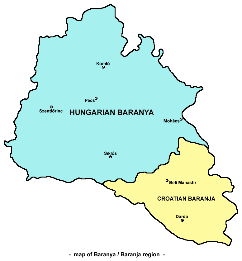
Branjina ( hu, Baranyakisfalud, sr-Cyrl, Брањина) is a settlement in the region of Baranja, Croatia. Administratively, it is located in the Popovac municipality within the Osijek-Baranja County. Population is 322 people. Until the end of World War II, the Inhabitants was Danube Swabians, also called locally as ''Stifolder'', because there Ancestors once came at the 17th century and 18th century from Fulda (district). Mostly of the former German Settlers was expelled to Allied-occupied Germany Germany was already de facto occupied by the Allies from the real fall of Nazi Germany in World War II on 8 May 1945 to the establishment of the East Germany on 7 October 1949. The Allies (United States, United Kingdom, Soviet Union, and Franc ... and Allied-occupied Austria in 1945-1948, about the Potsdam Agreement. References {{Authority control Populated places in Osijek-Baranja County Baranya (region) ... [...More Info...] [...Related Items...] OR: [Wikipedia] [Google] [Baidu] |
Popovac, Osijek-Baranja County
Popovac ( hu, Baranyabán, sr-Cyrl, Поповац) is a village and municipality in Osijek-Baranja County, Croatia. There are 2,084 inhabitants in the municipality (2011 census). Popovac is underdeveloped municipality which is statistically classified as the First Category Area of Special State Concern by the Government of Croatia. Until the end of World War II, the majority of the Inhabitants was Danube Swabians, also called locally as ''Stifolder'', because there Ancestors once came at the 17th century and 18th century from Fulda (district). Mostly of the former German Settlers was expelled to Allied-occupied Germany and Allied-occupied Austria in 1945-1948, about the Potsdam Agreement. Name Its name derived from the Slavic word "pop" ("priest" in English). In Hungarian, the village is known as ''Baranyabán''. Demographics As of 2011, ethnic groups in the municipality are: *71.40% Croats *17.03% Serbs *3.89% Hungarians *1.54% Romani *1.39% Slovenians Before World War ... [...More Info...] [...Related Items...] OR: [Wikipedia] [Google] [Baidu] |
Osijek-Baranja County
Osijek-Baranja County (, hr, Osječko-baranjska županija, hu, Eszék-Baranya megye) is a county in Croatia, located in northeastern Slavonia and Baranja. Its center is Osijek. Other towns include Đakovo, Našice, Valpovo, Belišće, and Beli Manastir. History Osijek-Baranja County was established in 1992, with border changes in 1997. Stifolder The ''Stifolder'' or ''Stiffoller Shvove'' are a Roman Catholic subgroup of the so called Danube Swabians. Their ancestors once came ca. 1717 - 1804 from the Hochstift Fulda and surroundings (Roman Catholic Diocese of Fulda), and settled in the Baranja area, such as in Jagodnjak, etc. They retained their own German dialect and culture, until the end of WW2. After WW2, the majority of Danube Swabians were expelled to Allied-occupied Germany and Allied-occupied Austria as a consequence of the Potsdam Agreement. Only a few people can speak the old Stiffolerisch Schvovish dialect. A salami is named after this people. Administrative di ... [...More Info...] [...Related Items...] OR: [Wikipedia] [Google] [Baidu] |
Baranya (region)
Baranya or Baranja ( hr, Baranja, ; hu, Baranya, ) is a geographical and historical region between the Danube and the Drava rivers. Its territory is divided between Hungary and Croatia. In Hungary, the region is included into Baranya county, while in Croatia, it is included into Osijek-Baranja county. Name The name of the region come from the Slavic word 'bara', which means 'marsh', 'bog', thus the name of Baranya means 'marshland'. Even today large parts of the region are swamps, such as the natural reservation Kopački Rit in its southeast. Another theory states that the name of the region comes from the Croatian and Hungarian word 'bárány', which means ram of 'ovis'. History Historically, the region of Baranya was part of the Roman Empire, the Hunnic Empire, the Kingdom of the Ostrogoths, the Kingdom of the Lombards, the Avar Kingdom, the Frankish Empire, the Balaton Principality, the Bulgarian Empire, the Kingdom of Hungary, the Ottoman Empire, the Habsburg monarc ... [...More Info...] [...Related Items...] OR: [Wikipedia] [Google] [Baidu] |
Croatia
, image_flag = Flag of Croatia.svg , image_coat = Coat of arms of Croatia.svg , anthem = "Lijepa naša domovino"("Our Beautiful Homeland") , image_map = , map_caption = , capital = Zagreb , coordinates = , largest_city = capital , official_languages = Croatian , languages_type = Writing system , languages = Latin , ethnic_groups = , ethnic_groups_year = 2021 , religion = , religion_year = 2021 , demonym = , government_type = Unitary parliamentary republic , leader_title1 = President , leader_name1 = Zoran Milanović , leader_title2 = Prime Minister , leader_name2 = Andrej Plenković , leader_title3 = Speaker of Parliament , leader_name3 = Gordan Jandroković , legislature = Sabor , sovereignty_type ... [...More Info...] [...Related Items...] OR: [Wikipedia] [Google] [Baidu] |
Danube Swabians
The Danube Swabians (german: Donauschwaben ) is a collective term for the ethnic German-speaking population who lived in various countries of central-eastern Europe, especially in the Danube River valley, first in the 12th century, and in greater numbers in the 17th and 18th centuries. Most were descended from earlier 18th-century Swabian settlers from Upper Swabia, the Swabian Jura, northern Lake Constance, the upper Danube, the Swabian-Franconian Forest, the Southern Black Forest and the Principality of Fürstenberg, followed by Hessians, Bavarians, Franconians and Lorrainers recruited by Austria to repopulate the area and restore agriculture after the expulsion of the Ottoman Empire. They were able to keep their language and religion and initially developed strongly German communities in the region with German folklore. Thousands also came from Eastern Europe. The Danube Swabians were given their German name by German ethnographers in the early 20th century. In the 21st cen ... [...More Info...] [...Related Items...] OR: [Wikipedia] [Google] [Baidu] |
Fulda (district)
The Fulda District (; ) is a ''Kreis'' (district) in the north-east of Hesse, Germany. Neighboring districts are Hersfeld-Rotenburg, Wartburgkreis, Schmalkalden-Meiningen, Rhön-Grabfeld, Bad Kissingen, Main-Kinzig, Vogelsbergkreis. History The district was created in 1821, when the duchy of Fulda became a province of Hesse, and was split into four districts. In 1866 the north of Hesse became a part of Prussia, including the Gersfeld area which previously belonged to Bavaria. In 1927 the city of Fulda left the district to become a district-free city, and in 1932 the remaining district was merged with the district of Gersfeld. In 1972, the previously small municipalities were merged into 23 bigger ones, and in 1974 the city of Fulda lost its status as district-free city and joined the district again. In 1972 the major part of the Hünfeld district was added to the district. Geography The district is located in the Rhön and Vogelsberg mountains. The main river of the district ... [...More Info...] [...Related Items...] OR: [Wikipedia] [Google] [Baidu] |
Allied-occupied Germany
Germany was already de facto occupied by the Allies from the real fall of Nazi Germany in World War II on 8 May 1945 to the establishment of the East Germany on 7 October 1949. The Allies (United States, United Kingdom, Soviet Union, and France) asserted joint authority and sovereignty at the 1945 Berlin Declaration. At first, defining Allied-occupied Germany as all territories of the former German Reich before Nazi annexing Austria; however later in the 1945 Potsdam Conference of Allies, the Potsdam Agreement decided the new German border as it stands today. Said border gave Poland and the Soviet Union all regions of Germany (eastern parts of Pomerania, Neumark, Posen-West Prussia, Free City of Danzig, East-Prussia & Silesia) east of the Oder–Neisse line and divided the remaining "Germany as a whole" into the four occupation zones for administrative purposes under the three Western Allies (the United States, the United Kingdom, and France) and the Soviet Union. Although the ... [...More Info...] [...Related Items...] OR: [Wikipedia] [Google] [Baidu] |
Allied-occupied Austria
The Allied occupation of Austria started on 8 May 1945 with the fall of Nazi Germany and ended with the Austrian State Treaty on 27 July 1955. After the in 1938, Austria had generally been recognized as part of Nazi Germany. In 1943, however, the Allies agreed in the Declaration of Moscow that Austria would instead be regarded as the first victim of Nazi aggression, and treated as a liberated and independent country after the war. In the immediate aftermath of World War II, Austria was divided into four zones and jointly occupied by the United Kingdom, the Soviet Union, the United States, and France. Vienna was similarly subdivided, but the central district was collectively administered by the Allied Control Council. Whereas Germany was divided into East and West Germany in 1949, Austria remained under joint occupation of the Western Allies and the Soviet Union until 1955; its status became a controversial subject in the Cold War until the warming of relations known as th ... [...More Info...] [...Related Items...] OR: [Wikipedia] [Google] [Baidu] |
Potsdam Agreement
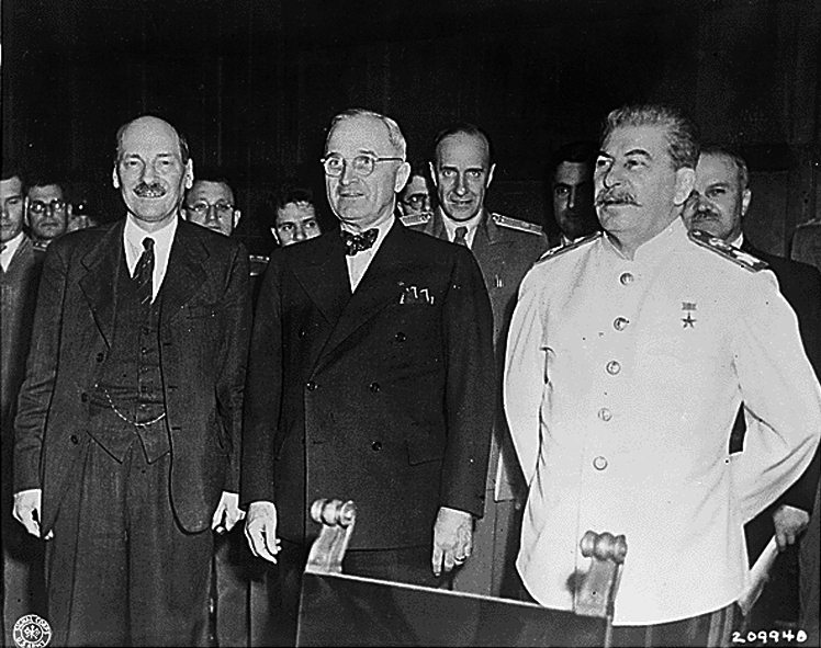
The Potsdam Agreement (german: Potsdamer Abkommen) was the agreement between three of the Allies of World War II: the United Kingdom, the United States, and the Soviet Union on 1 August 1945. A product of the Potsdam Conference, it concerned the military occupation and reconstruction of Germany, its border, and the entire European Theatre of War territory. It also addressed Germany's demilitarisation, reparations, the prosecution of war criminals and the Flight and expulsion of Germans (1944–1950), mass expulsion of ethnic Germans from various parts of Europe. Executed as a communiqué, the agreement was not a peace treaty according to international law, although it created accomplished facts. It was superseded by the Treaty on the Final Settlement with Respect to Germany signed on 12 September 1990. As De Gaulle had not been invited to the Conference, the French resisted implementing the Potsdam Agreements within their occupation zone. In particular, the French refused to ... [...More Info...] [...Related Items...] OR: [Wikipedia] [Google] [Baidu] |
Populated Places In Osijek-Baranja County
Population typically refers to the number of people in a single area, whether it be a city or town, region, country, continent, or the world. Governments typically quantify the size of the resident population within their jurisdiction using a census, a process of collecting, analysing, compiling, and publishing data regarding a population. Perspectives of various disciplines Social sciences In sociology and population geography, population refers to a group of human beings with some predefined criterion in common, such as location, race, ethnicity, nationality, or religion. Demography is a social science which entails the statistical study of populations. Ecology In ecology, a population is a group of organisms of the same species who inhabit the same particular geographical area and are capable of interbreeding. The area of a sexual population is the area where inter-breeding is possible between any pair within the area and more probable than cross-breeding with in ... [...More Info...] [...Related Items...] OR: [Wikipedia] [Google] [Baidu] |


