|
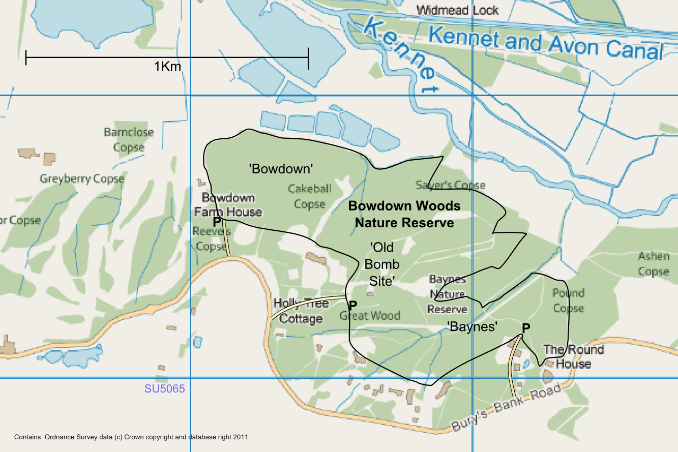
Bowdown Woods (1)
Bowdown and Chamberhouse Woods is a biological Site of Special Scientific Interest south of Thatcham in Berkshire. An area of is a nature reserve managed by the Berkshire, Buckinghamshire and Oxfordshire Wildlife Trust. The site is an area of ancient woodland lying on the scarp slope north of Greenham Common, close to the eastern edge of Newbury, most of which is a Nature Reserve open to the public. Nature Reserve It has a diverse range of tree species, an 'exceptionally rich woodland ground flora' and a diverse fauna, notably birds, reptiles, dragonflies and butterflies. The Nature Reserve is open to the public and has three car parks, all accessed from Bury's Bank Road, between Greenham and Thatcham. The three access points relate to the three areas of the reserve, each of which has its own history. Baynes Wood Baynes Wood (itself comprising Great Wood and Parklodge Gully) is at the south-eastern end of the reserve, and may have been part of Chamberhouse Park. It is shown ... [...More Info...] [...Related Items...] OR: [Wikipedia] [Google] [Baidu] |
Site Of Special Scientific Interest
A Site of Special Scientific Interest (SSSI) in Great Britain or an Area of Special Scientific Interest (ASSI) in the Isle of Man and Northern Ireland is a conservation designation denoting a protected area in the United Kingdom and Isle of Man. SSSI/ASSIs are the basic building block of site-based nature conservation legislation and most other legal nature/geological conservation designations in the United Kingdom are based upon them, including national nature reserves, Ramsar sites, Special Protection Areas, and Special Areas of Conservation. The acronym "SSSI" is often pronounced "triple-S I". Selection and conservation Sites notified for their biological interest are known as Biological SSSIs (or ASSIs), and those notified for geological or physiographic interest are Geological SSSIs (or ASSIs). Sites may be divided into management units, with some areas including units that are noted for both biological and geological interest. Biological Biological SSSI/ASSIs may ... [...More Info...] [...Related Items...] OR: [Wikipedia] [Google] [Baidu] |
Thatcham
Thatcham is an historic market town and civil parish in the English county of Berkshire, centred 3 miles (5 km) east of Newbury, 14 miles (24 km) west of Reading and 54 miles (87 km) west of London. Geography Thatcham straddles the River Kennet, the Kennet and Avon Canal and the A4. The parish currently covers the town of Thatcham, with its suburbs of Henwick, Dunston Park and Colthrop, and the village of Crookham including Crookham Common and the eastern ranges of the old RAF Greenham Common airfield. The historic parish once also covered Midgham, Cold Ash, Ashmore Green and Greenham. Thatcham Reed Beds, just to the south of the town, is a site of Special Scientific Interest (SSSI). Etymology The name may have been derived from that of a Saxon chief called ''Tace'' (or perhaps ''Tac'' or ''Tec''), who established a village in around 500 AD. The settlement might have been known as ''Taceham'' - ''ham'' meaning village in Saxon. However some of the earliest ... [...More Info...] [...Related Items...] OR: [Wikipedia] [Google] [Baidu] |
Berkshire
Berkshire ( ; in the 17th century sometimes spelt phonetically as Barkeshire; abbreviated Berks.) is a historic county in South East England. One of the home counties, Berkshire was recognised by Queen Elizabeth II as the Royal County of Berkshire in 1957 because of the presence of Windsor Castle, and letters patent were issued in 1974. Berkshire is a county of historic origin, a ceremonial county and a non-metropolitan county without a county council. The county town is Reading. The River Thames formed the historic northern boundary, from Buscot in the west to Old Windsor in the east. The historic county, therefore, includes territory that is now administered by the Vale of White Horse and parts of South Oxfordshire in Oxfordshire, but excludes Caversham, Slough and five less populous settlements in the east of the Royal Borough of Windsor and Maidenhead. All the changes mentioned, apart from the change to Caversham, took place in 1974. The towns of Abingdon, Didcot, Far ... [...More Info...] [...Related Items...] OR: [Wikipedia] [Google] [Baidu] |
Berkshire, Buckinghamshire And Oxfordshire Wildlife Trust
The Berkshire, Buckinghamshire and Oxfordshire Wildlife Trust (BBOWT), is a wildlife trust covering the counties of Berkshire, Buckinghamshire and Oxfordshire in England England is a country that is part of the United Kingdom. It shares land borders with Wales to its west and Scotland to its north. The Irish Sea lies northwest and the Celtic Sea to the southwest. It is separated from continental Europe b .... The trust was formerly called the Berkshire, Buckinghamshire and Oxfordshire Naturalists' Trust (BBONT). __TOC__ Sites Berkshire Buckinghamshire Oxfordshire Notes References External links Berkshire, Buckinghamshire and Oxfordshire Wildlife Trust website {{DEFAULTSORT:Berkshire, Buckinghamshire And Oxfordshire Wildlife Trust Wildlife Trusts of England ... [...More Info...] [...Related Items...] OR: [Wikipedia] [Google] [Baidu] |
Newbury, Berkshire
Newbury is a market town in the county of Berkshire, England, and is home to the administrative headquarters of West Berkshire Council. The town centre around its large market square retains a rare medieval Cloth Hall, an adjoining half timbered granary, and the 15th-century St Nicolas Church, along with 17th- and 18th-century listed buildings. As well as being home to Newbury Racecourse, it is the headquarters of Vodafone and software company Micro Focus International. In the valley of the River Kennet, south of Oxford, north of Winchester, southeast of Swindon and west of Reading. Newbury lies on the edge of the Berkshire Downs; part of the North Wessex Downs Area of outstanding natural beauty, north of the Hampshire-Berkshire county boundary. In the suburban village of Donnington lies the part-ruined Donnington Castle and the surrounding hills are home to some of the country's most famous racehorse training grounds (centred on nearby Lambourn). To the south is a narro ... [...More Info...] [...Related Items...] OR: [Wikipedia] [Google] [Baidu] |
RAF Greenham Common
Royal Air Force Greenham Common or RAF Greenham Common is a former Royal Air Force station in the civil parishes of Greenham and Thatcham in the English county of Berkshire. The airfield was southeast of Newbury, about west of London. Opened in 1942, it was used by the United States Air Force during the Second World War and during the Cold War, and later as a base for nuclear weapons. After the Cold War ended, it was closed in September 1992. The airfield was also known for the Greenham Common Women's Peace Camp held outside its gates in the 1980s in protest against the stationing of cruise missiles on the base. In 1997 Greenham Common was designated as public parkland. History Second World War The Greenham Lodge Estate, which was set in the midst on Greenham Common, was requisitioned by the Air Ministry in 1941. The first arrival was the U.S. Army Air Forces (USAAF) 51st Troop Carrier Wing Headquarters, arriving in September 1942. The 51st TCW controlled the three troop c ... [...More Info...] [...Related Items...] OR: [Wikipedia] [Google] [Baidu] |
Sites Of Special Scientific Interest In Berkshire
Site most often refers to: * Archaeological site * Campsite, a place used for overnight stay in an outdoor area * Construction site * Location, a point or an area on the Earth's surface or elsewhere * Website, a set of related web pages, typically with a common domain name It may also refer to: * Site, a National Register of Historic Places property type * SITE (originally known as ''Sculpture in the Environment''), an American architecture and design firm * Site (mathematics), a category C together with a Grothendieck topology on C * ''The Site'', a 1990s TV series that aired on MSNBC * SITE Intelligence Group, a for-profit organization tracking jihadist and white supremacist organizations * SITE Institute, a terrorism-tracking organization, precursor to the SITE Intelligence Group * Sindh Industrial and Trading Estate, a company in Sindh, Pakistan * SITE Centers, American commercial real estate company * SITE Town, a densely populated town in Karachi, Pakistan * S.I.T.E Indust ... [...More Info...] [...Related Items...] OR: [Wikipedia] [Google] [Baidu] |
Sites Of Special Scientific Interest Notified In 1983
Site most often refers to: * Archaeological site * Campsite, a place used for overnight stay in an outdoor area * Construction site * Location, a point or an area on the Earth's surface or elsewhere * Website, a set of related web pages, typically with a common domain name It may also refer to: * Site, a National Register of Historic Places property type * SITE (originally known as ''Sculpture in the Environment''), an American architecture and design firm * Site (mathematics), a category C together with a Grothendieck topology on C * ''The Site'', a 1990s TV series that aired on MSNBC * SITE Intelligence Group, a for-profit organization tracking jihadist and white supremacist organizations * SITE Institute, a terrorism-tracking organization, precursor to the SITE Intelligence Group * Sindh Industrial and Trading Estate, a company in Sindh, Pakistan * SITE Centers, American commercial real estate company * SITE Town, a densely populated town in Karachi, Pakistan * S.I.T.E Indust ... [...More Info...] [...Related Items...] OR: [Wikipedia] [Google] [Baidu] |
Forests And Woodlands Of Berkshire
A forest is an area of land dominated by trees. Hundreds of definitions of forest are used throughout the world, incorporating factors such as tree density, tree height, land use, legal standing, and ecological function. The United Nations' Food and Agriculture Organization (FAO) defines a forest as, "Land spanning more than 0.5 hectares with trees higher than 5 meters and a canopy cover of more than 10 percent, or trees able to reach these thresholds ''in situ''. It does not include land that is predominantly under agricultural or urban use." Using this definition, '' Global Forest Resources Assessment 2020'' (FRA 2020) found that forests covered , or approximately 31 percent of the world's land area in 2020. Forests are the predominant terrestrial ecosystem of Earth, and are found around the globe. More than half of the world's forests are found in only five countries (Brazil, Canada, China, Russia, and the United States). The largest share of forests (45 percent) are in th ... [...More Info...] [...Related Items...] OR: [Wikipedia] [Google] [Baidu] |


.jpg)
