|
Borrego Valley Groundwater Basin
Borrego Valley Groundwater Basin, located in the very southern region of California, is one of the driest basins in the state. With climate change predicted to have strong effects into foreseeable future, the region is viewed with a skepticism in the sustainable use of water at current rates of consumption. Both natural and man-made geographic divisions within this basin allow for a closer inspection of the various management techniques implemented throughout the years, and provide a basis for what may be pursued for an uncertain future. Geography of region The Borrego Valley Groundwater Basin is housed underneath the Borrego Valley, which lies in both San Diego and Imperial counties of southern California. It reaches from the San Ysidro Mountains in San Diego County, to the east, where it enters Imperial County. As of 2016, the California Department of Water Resources split this basin into two sub-basins, Borrego Springs and Ocotillo Wells. The total surface area of this basi ... [...More Info...] [...Related Items...] OR: [Wikipedia] [Google] [Baidu] |
California Department Of Water Resources
The California Department of Water Resources (DWR) is part of the California Natural Resources Agency and is responsible for the management and regulation of the State of California's water usage. The department was created in 1956 by Governor Goodwin Knight following severe flooding across Northern California in 1955, where they combined the Division of Water Resources of the Department of Public Works with the State Engineer's Office, the Water Project Authority, and the State Water Resources Board. It is headquartered in Sacramento. History 1850-1875 California recognizes many types of water rights. Prior to the Treaty of Guadalupe Hidalgo, signed in 1848, California was part of Mexico. Riparian rights were the most prevalent type of water right. Under riparian rights, which have their origins in Roman law, a landowner can use water flowing by his property for use on his property. When California became part of the United States, the United States agreed to recognize exist ... [...More Info...] [...Related Items...] OR: [Wikipedia] [Google] [Baidu] |
Anza-Borrego Desert State Park
Anza-Borrego Desert State Park (, '' AN-zə bə-RAY-goh'') is a California State Park located within the Colorado Desert of southern California, United States. The park takes its name from 18th century Spanish explorer Juan Bautista de Anza and ''borrego'', a Spanish word for sheep. With that includes one-fifth of San Diego County, it is the largest state park in California. The park occupies eastern San Diego County and reaches into Imperial and Riverside counties, enveloping two communities: Borrego Springs, which is home to the park's headquarters, and Shelter Valley. Geography The park is an anchor in the Mojave and Colorado Deserts Biosphere Reserve, and adjacent to the Santa Rosa and San Jacinto Mountains National Monument. The great bowl of the surrounding desert is surrounded by mountains, with the Vallecito Mountains to the south and the highest Santa Rosa Mountains to the north which are in the wilderness area, without paved roads and with the only year-round c ... [...More Info...] [...Related Items...] OR: [Wikipedia] [Google] [Baidu] |
United States Geological Survey
The United States Geological Survey (USGS), formerly simply known as the Geological Survey, is a scientific agency of the United States government. The scientists of the USGS study the landscape of the United States, its natural resources, and the natural hazards that threaten it. The organization's work spans the disciplines of biology, geography, geology, and hydrology. The USGS is a fact-finding research organization with no regulatory responsibility. The agency was founded on March 3, 1879. The USGS is a bureau of the United States Department of the Interior; it is that department's sole scientific agency. The USGS employs approximately 8,670 people and is headquartered in Reston, Virginia. The USGS also has major offices near Lakewood, Colorado, at the Denver Federal Center, and Menlo Park, California. The current motto of the USGS, in use since August 1997, is "science for a changing world". The agency's previous slogan, adopted on the occasion of its hundredt ... [...More Info...] [...Related Items...] OR: [Wikipedia] [Google] [Baidu] |
Groundwater Recharge
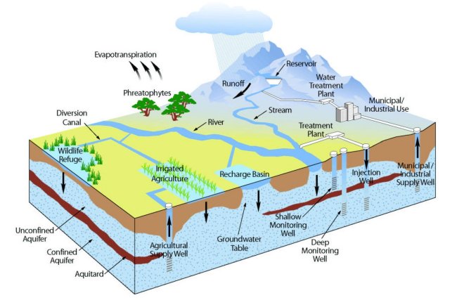
Groundwater recharge or deep drainage or deep percolation is a hydrologic process, where water moves downward from surface water to groundwater. Recharge is the primary method through which water enters an aquifer. This process usually occurs in the vadose zone below plant roots and is often expressed as a flux to the water table surface. Groundwater recharge also encompasses water moving away from the water table farther into the saturated zone. Recharge occurs both naturally (through the water cycle) and through anthropogenic processes (i.e., "artificial groundwater recharge"), where rainwater and or reclaimed water is routed to the subsurface. Processes Water is recharged naturally by rain and snow melt and to a smaller extent by surface water (rivers and lakes). Recharge may be impeded somewhat by human activities including paving, development, or logging. These activities can result in loss of topsoil resulting in reduced water infiltration, enhanced surface runoff and ... [...More Info...] [...Related Items...] OR: [Wikipedia] [Google] [Baidu] |
Salton Sea
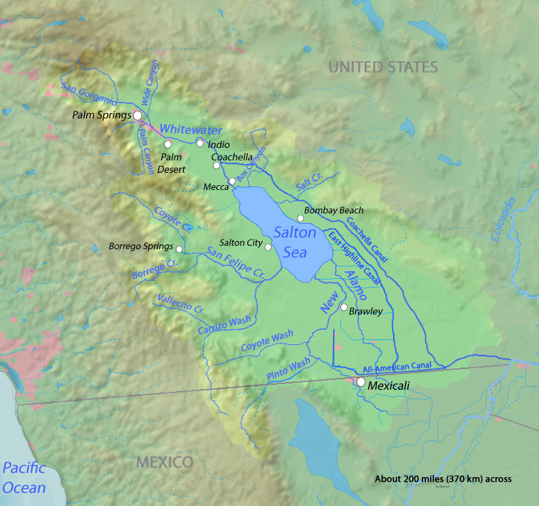
The Salton Sea is a shallow, landlocked, highly saline body of water in Riverside and Imperial counties at the southern end of the U.S. state of California. It lies on the San Andreas Fault within the Salton Trough that stretches to the Gulf of California in Mexico. Over millions of years, the Colorado River has flowed into the Imperial Valley and deposited alluvium (soil), creating fertile farmland, building up the terrain, and constantly moving its main course and river delta. For thousands of years, the river has alternately flowed into the valley, or diverted around it, creating either a saline lake called Lake Cahuilla, or a dry desert basin, respectively. When the Colorado River flows into the valley, the lake level depends on river flows and the balance between inflow and evaporative loss. When the river diverts around the valley, the lake dries completely, as it did around 1580. Hundreds of archaeological sites have been found in this region, indicating possibly long-ter ... [...More Info...] [...Related Items...] OR: [Wikipedia] [Google] [Baidu] |
Sustainable Groundwater Management Act
The Sustainable Groundwater Management Act (SGMA) is a three-bill package that passed the California state legislature and was signed into California state law by Governor Jerry Brown in September 2014. Its purpose is to ensure better local and regional management of groundwater use and it seeks to have a sustainable groundwater management in California by 2042. It emphasizes local management and formed groundwater sustainability agencies (GSAs) from local and regional authorities. Proposition 1 provides $100 million to financially support sustainable groundwater management as well as cleanup and storage. Background Groundwater in California is used by 85% of the population, mostly used by the agriculture industry as the main water source for crops. For years, groundwater use has been poorly managed and under-regulated to a point where the state is facing major depletion. Groundwater is particularly crucial in California because the dearth of surface water means that it ... [...More Info...] [...Related Items...] OR: [Wikipedia] [Google] [Baidu] |
Geography Of San Diego County, California
Geography (from Greek: , ''geographia''. Combination of Greek words ‘Geo’ (The Earth) and ‘Graphien’ (to describe), literally "earth description") is a field of science devoted to the study of the lands, features, inhabitants, and phenomena of Earth. The first recorded use of the word γεωγραφία was as a title of a book by Greek scholar Eratosthenes (276–194 BC). Geography is an all-encompassing discipline that seeks an understanding of Earth and its human and natural complexities—not merely where objects are, but also how they have changed and come to be. While geography is specific to Earth, many concepts can be applied more broadly to other celestial bodies in the field of planetary science. One such concept, the first law of geography, proposed by Waldo Tobler, is "everything is related to everything else, but near things are more related than distant things." Geography has been called "the world discipline" and "the bridge between the human a ... [...More Info...] [...Related Items...] OR: [Wikipedia] [Google] [Baidu] |
Landforms Of California
A landform is a natural or anthropogenic land feature on the solid surface of the Earth or other planetary body. Landforms together make up a given terrain, and their arrangement in the landscape is known as topography. Landforms include hills, mountains, canyons, and valleys, as well as shoreline features such as bays, peninsulas, and seas, including submerged features such as mid-ocean ridges, volcanoes, and the great ocean basins. Physical characteristics Landforms are categorized by characteristic physical attributes such as elevation, slope, orientation, stratification, rock exposure and soil type. Gross physical features or landforms include intuitive elements such as berms, mounds, hills, ridges, cliffs, valleys, rivers, peninsulas, volcanoes, and numerous other structural and size-scaled (e.g. ponds vs. lakes, hills vs. mountains) elements including various kinds of inland and oceanic waterbodies and sub-surface features. Mountains, hills, plateaux, and plains are the fou ... [...More Info...] [...Related Items...] OR: [Wikipedia] [Google] [Baidu] |
.jpg)


.jpg)