|
Blackwood Plateau
Blackwood Plateau is a part of the Blackwood River landscape between the Whicher Scarp and the Scott Coastal Plain Scott Coastal Plain is a plain that lies between the Blackwood Plateau and the south coast of Western Australia, east of Augusta and Cape Leeuwin. The name of the plain is derived from the river that drains the western portion of the plain, the ... in Southwest Australia. It is also known as the Donnybrook sunkland. Notes {{reflist, 30em Blackwood River ... [...More Info...] [...Related Items...] OR: [Wikipedia] [Google] [Baidu] |
Blackwood River
The Blackwood River is a major river and catchment in the South West of Western Australia. Course The river begins at the junction of Arthur River and Balgarup River near Quelarup and travels in a south westerly direction through the town of Bridgetown then through Nannup until it discharges into the Southern Ocean at Hardy Inlet near the town of Augusta. Hardy Inlet has a number of islands – namely Molloy Island and Thomas Island. The mouth of the river has attracted interest in its various points of opening and closing over the last 100 years, Duke Head at the west side being a benchmark location for the shifting mouth. The river has 42 tributaries including Dinninup Brook, Balingup Brook, St John Brook, Boyup Brook, Tweed River, Ti Tree Gully, Christmas Creek and Tanjannerup Creek. Catchment The river has a total catchment area of stretching from Kukerin in the east to Hardy Inlet in the west, and from Darkan in the north to Augusta in the south. Several m ... [...More Info...] [...Related Items...] OR: [Wikipedia] [Google] [Baidu] |
Whicher Scarp
Whicher Range, also known as Whicher Scarp, is a range in the South West region of Western Australia. The range has an average elevation of above sea level. Bounded by the Swan Coastal Plain to the west and the south, the Darling Scarp to the north and the Blackwood Plateau to the east, the range is approximately south of Busselton. The range has the form of a crescent shaped scarp. Composed of lateritic Mesozoic sediments, the range marks the southern and western edge of the Yilgarn Block. Ecological fragility The range is also the location of endemic rare flora and this had been identified in the 1970s. It has also been surveyed more recently in 2008, showing that further interest in the range's floristic uniqueness deserved more study. The most critically endangered species that inhabits the Whicher range is ''Petrophile latericola'' also known as Laterite petrophile, Ironstone Petrophile or the Ironstone Pixie Mop, which has a range of approximately within t ... [...More Info...] [...Related Items...] OR: [Wikipedia] [Google] [Baidu] |
Scott Coastal Plain
Scott Coastal Plain is a plain that lies between the Blackwood Plateau and the south coast of Western Australia, east of Augusta and Cape Leeuwin. The name of the plain is derived from the river that drains the western portion of the plain, the Scott River The Scott River is a U.S. Geological Survey. National Hydrography Dataset high-resolution flowline dataThe National Map accessed March 9, 2011 river in Siskiyou County, California, United States. It is a tributary of the Klamath River, one of the .... Notes {{reflist, 30em South West (Western Australia) ... [...More Info...] [...Related Items...] OR: [Wikipedia] [Google] [Baidu] |
Southwest Australia
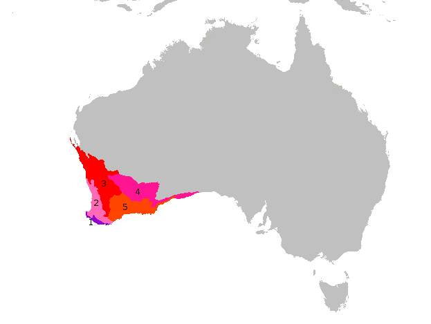
Southwest Australia is a biogeographic region in Western Australia. It includes the Mediterranean-climate area of southwestern Australia, which is home to a diverse and distinctive flora and fauna. The region is also known as the Southwest Australia Global Diversity Hotspot, as well as Kwongan. Geography The region includes the Mediterranean forests, woodlands, and scrub ecoregions of Western Australia. The region covers 356,717 km2, consisting of a broad coastal plain 20-120 kilometres wide, transitioning to gently undulating uplands made up of weathered granite, gneiss and laterite. Bluff Knoll in the Stirling Range is the highest peak in the region, at 1,099 metres (3,606 ft) elevation. Desert and xeric shrublands lie to the north and east across the centre of Australia, separating Southwest Australia from the other Mediterranean and humid-climate regions of the continent. Climate The region has a wet-winter, dry-summer Mediterranean climate, one of five such regio ... [...More Info...] [...Related Items...] OR: [Wikipedia] [Google] [Baidu] |

