|
Black Rock (Great Salt Lake)
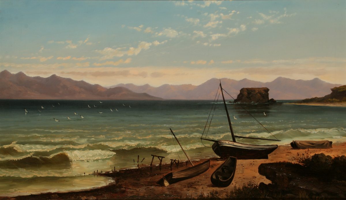
The Black Rock on Great Salt Lake near Lake Point, Utah is a historic landmark. It was added to the National Register of Historic Places in 2021 as part of the Black Rock Site. The site includes Black Rock and foundation ruins of the former Black Rock Resort. The site was the location, in 1847, of "the first recreational bathing in the Great Salt Lake in recorded history." The ill-fated Donner Party, taking the Hastings Cutoff alternative route to California, came by in 1846. Journal entries and interviews describe the Donner Party meeting the "Hastings Trail" on the south side of the Great Salt Lake in August 1846. In later interviews Donner Party member, Reed, was quoted multiple times saying that they had met Lansford Hastings near the landmark (on the eastern border of Lake Point) known as Black Rock and that they were the ones who had given the rock its name. The rock was described in 1870 by travel guide writer Fitz Ludlow as grim and ugly, yet part of a charming scene:"A ... [...More Info...] [...Related Items...] OR: [Wikipedia] [Google] [Baidu] |
Great Salt Lake
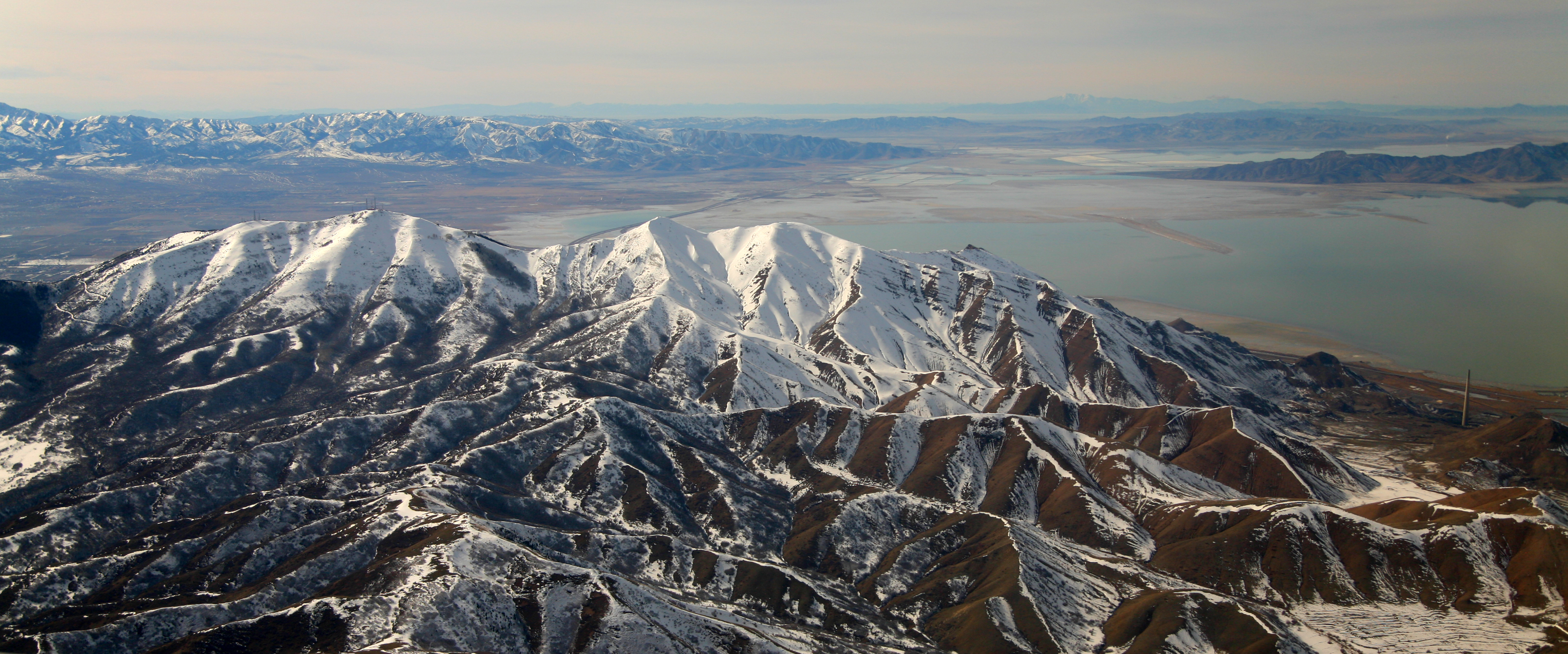
The Great Salt Lake is the largest saltwater lake in the Western Hemisphere and the eighth-largest terminal lake in the world. It lies in the northern part of the U.S. state of Utah and has a substantial impact upon the local climate, particularly through lake-effect snow. It is a remnant of Lake Bonneville, a prehistoric body of water that covered much of western Utah. The area of the lake can fluctuate substantially due to its low average depth of . In the 1980s, it reached a historic high of , and the West Desert Pumping Project was established to mitigate flooding by pumping water from the lake into the nearby desert. In 2021, after years of sustained drought and increased water diversion upstream of the lake, it fell to its lowest recorded area at 950 square miles (2,460 km²), falling below the previous low set in 1963. Continued shrinkage could turn the lake into a bowl of toxic dust, poisoning the air around Salt Lake City. The lake's three major tributaries, the ... [...More Info...] [...Related Items...] OR: [Wikipedia] [Google] [Baidu] |
Alfred Lambourne
Alfred Lambourne (February 2, 1850 – June 6, 1926) is an English-born American artist and author. In the 1860s, he and his family moved to the American West with the Mormon pioneers. He is best remembered for his paintings, but he also wrote short fiction for Mormon periodicals, accessed Feb. 27, 2009 and other works of musings and poetry. Biography Lambourne was born to William and Martha Wernham in , Berkshire, England on the River Lambourn. The family e ...[...More Info...] [...Related Items...] OR: [Wikipedia] [Google] [Baidu] |
National Register Of Historic Places In Salt Lake County, Utah
This is a list of the National Register of Historic Places listings in Salt Lake County, Utah, except those in Salt Lake City. Listings for Salt Lake City can be found here. This is intended to be a complete list of the properties and districts on the National Register of Historic Places in Salt Lake County, Utah, United States. Latitude and longitude coordinates are provided for many National Register properties and districts; these locations may be seen together in a map. There are more than 350 properties and districts listed on the National Register in the county, including six National Historic Landmarks. More than 200 of these sites, including four National Historic Landmarks, are located in Salt Lake City, and are listed separately; the 146 sites outside the city, including two National Historic Landmarks, are listed here. Six other sites in the county outside of Salt Lake City were once listed on the Register, but have been removed. __TOC__ Current listings ... [...More Info...] [...Related Items...] OR: [Wikipedia] [Google] [Baidu] |
National Register Of Historic Places In Tooele County, Utah
This is a list of the National Register of Historic Places listings in Tooele County, Utah. This is intended to be a complete list of the properties and districts on the National Register of Historic Places in Tooele County, Utah, Tooele County, Utah, United States. Latitude and longitude coordinates are provided for many National Register properties and districts; these locations may be seen together in a map. There are 29 properties listed on the National Register in the county, including 1 National Historic Landmark. __TOC__ Current listings See also * List of National Historic Landmarks in Utah * National Register of Historic Places listings in Utah References External links {{Tooele County, Utah Lists of National Register of Historic Places in Utah by county, Tooele Tooele County, Utah, * National Register of Historic Places in Tooele County, Utah, * ... [...More Info...] [...Related Items...] OR: [Wikipedia] [Google] [Baidu] |
Adobe Rock
Adobe Rock is described by the USGS as a pediment (geology) at Lake Point, Utah. The large rock outcropping sits adjacent to SR-36 just north of SR-138 at Mills Junction. Because of its distance from the steep incline of the Oquirrh Mountains and its prominent location on the edge of a hill, Adobe Rock has served as a natural landmark in Tooele Valley ever since the first pioneers traversed the Hastings Cutoff trail. Though not officially a national monument like its nearby peer Black Rock (Great Salt Lake), it has equal significance as a navigating landmark and cultural significance as a monument with businesses using the Adobe Rock name, books using its images on their covers, and Lake Point, Utah depicting its likeness as their city logo. History On July 27, 1947, The Daughters of Utah Pioneers installed a Utah Historical Marker on the west side of Adobe Rock to designate it as a historical monument in Tooele County, Utah. The marker says it was placed by the Tooele County C ... [...More Info...] [...Related Items...] OR: [Wikipedia] [Google] [Baidu] |
Antelope Island
Antelope Island, with an area of 42 square miles (109 km2), is the largest of ten islands located within the Great Salt Lake in the US state of Utah. The island lies in the southeastern portion of the lake, near Salt Lake City and Davis County, and becomes a peninsula when the lake is at extremely low levels. It is protected as Antelope Island State Park. The first known non-natives to visit the island were John C. Frémont and Kit Carson during exploration of the Great Salt Lake in 1845, who "rode on horseback over salt from the thickness of a wafer to twelve inches" and "were informed by the Indians that there was an abundance of fresh water on it and plenty of antelope". It is said they shot a pronghorn antelope on the island and in gratitude for the meat they named it Antelope Island. Antelope Island has natural scenic beauty and holds populations of pronghorn, bighorn sheep, American bison, porcupine, badger, coyote, bobcat, mule deer, and millions of waterfowl. The bis ... [...More Info...] [...Related Items...] OR: [Wikipedia] [Google] [Baidu] |
Oquirrh Mountains
The Oquirrh Mountains is a mountain range that runs north-south for approximately 30 miles (50 km) to form the west side of Utah's Salt Lake Valley, separating it from Tooele Valley. The range runs from northwestern Utah County–central & eastern Tooele County, to the south shore of the Great Salt Lake. The highest elevation is Flat Top Mountain at 10,620 ft (3,237 m). The name Oquirrh was taken from the Goshute word meaning "wood sitting."William Bright, ed. ''Native American Placenames of the United States'' (2004, University of Oklahoma Press) The Oquirrh Mountains have been mined for gold, silver, lead, and most famously for copper, as home of the porphyry copper deposit at Bingham Canyon Mine The Bingham Canyon Mine, more commonly known as Kennecott Copper Mine among locals, is an open-pit mining operation extracting a large porphyry copper deposit southwest of Salt Lake City, Utah, in the Oquirrh Mountains. The mine is the largest m ..., one of the worl ... [...More Info...] [...Related Items...] OR: [Wikipedia] [Google] [Baidu] |
Salt Lake County, Utah
Salt Lake County is located in the U.S. state of Utah. As of the 2020 United States Census, the population was 1,185,238, making it the most populous county in Utah. Its county seat and largest city is Salt Lake City, the state capital. The county was created in 1850. Salt Lake County is the 37th most populated county in the United States and is one of four counties in the Rocky Mountains to make it into the top 100. (Others being Denver County and El Paso County, Colorado and Clark County, Nevada.) Salt Lake County is the only county of the first class in Utah - under the Utah Code (Title 17, Chapter 50, Part 5) is a county with a population of 700,000 or greater. Salt Lake County occupies the Salt Lake Valley, as well as parts of the surrounding mountains, the Oquirrh Mountains to the west and the Wasatch Range to the east (essentially the entire Jordan River watershed north of the Traverse Mountains). In addition, the northwestern section of the county includes part of th ... [...More Info...] [...Related Items...] OR: [Wikipedia] [Google] [Baidu] |
Tooele County, Utah
Tooele County ( ) is a County (United States), county in the U.S. state of Utah. As of the 2010 United States Census, the population was 58,218. Its county seat and largest city is Tooele, Utah, Tooele. The county was created in 1850 and organized the following year. Tooele County is part of the Salt Lake City, UT Salt Lake City metropolitan area, Metropolitan Statistical Area. A 2008 CNNMoney.com article identified Tooele as the County (United States), U.S. county experiencing the greatest job growth since 2000. The western half is mostly covered by the Great Salt Lake Desert and includes the city of Wendover, Utah, Wendover (the immediate neighbor of West Wendover, Nevada) and Ibapah, Utah, Ibapah. Within the central section lies Skull Valley, between the Cedar Mountains (Tooele County, Utah), Cedar and the Stansbury Mountains. It contains a few small towns as well as the Dugway Proving Ground. The population centers are on the eastern edge in the Tooele Valley, between the S ... [...More Info...] [...Related Items...] OR: [Wikipedia] [Google] [Baidu] |
Albert Tissandier
Albert Tissandier (1839 – 5 September 1906) was a French architect, aviator, illustrator, editing, editor and archaeologist. He was the brother of adventurer Gaston Tissandier with whom he collaborated in writing the magazine ''La Nature'', a French language scientific journal aimed at the popular science, popularization of science. He and his brother demonstrated the first electric powered flight. Early years and ''La Nature'' Born in Paris in 1839, Albert Tissandier was a loyal and assiduous companion of his brother, Gaston Tissandier. As an architect, he was involved in a large number of projects. Though his brother was nominally the sole founder of ''La Nature'', a scientific journal aimed at the popularization of science, Albert contributed extensively to the magazine, mostly as an illustrator and editor. He was heavily involved in it from the very first issue in 1873 until his retirement in 1905, less than a year before his death. Aviation career His devotion to aer ... [...More Info...] [...Related Items...] OR: [Wikipedia] [Google] [Baidu] |
James Taylor Harwood
James Taylor Harwood (8 April 1860, Lehi, Utah – 16 October 1940, Salt Lake City) was an American painter, engraver and art teacher. He was the first artist from Utah to exhibit at the Salon (Paris), Paris Salon, in 1892.Doris Ostrander Dawdy, ''Artists of the American West : a biographical dictionary'', Chicago, Sage Books, 1974 Biography He was born to James Harwood, a maker of Horse harness, harnesses, and his wife Sarah Jane née Taylor. He displayed an early talent for art; taking lessons with the local painters, George M. Ottinger, Alfred Lambourne and Dan Weggeland. This was followed, in 1885, by studies at the San Francisco Art Institute, California School of Design in San Francisco, under the direction of Virgil Macey Williams.*Robert S. Olpin, ''Artists of Utah'', Salt Lake City, Gibbs Smith, 1999 He returned to Utah in 1887 and opened a studio, painting portraits and giving lessons. One of his students, Harriet Richards (1870-1922), would later become his wife.Wil ... [...More Info...] [...Related Items...] OR: [Wikipedia] [Google] [Baidu] |
Waldo Midgley
Waldo may refer to: People * Waldo (given name), a list of people and fictional characters * Waldo (surname), a list of people * Waldo (footballer) (1934-2019), full name Waldo Machado da Silva, Brazilian footballer Places Canada * Waldo, British Columbia, a ghost town United States Inhabited places * Waldo, Alabama, a town * Waldo, Arkansas, a city * Waldo, former name of Sausalito, California, a city * Waldo Junction, California, formerly Waldo, an unincorporated community * Waldo, Florida, a city ** Waldo Historic District, Waldo, Florida * Waldo, Kansas, a small town ** Waldo Township, Russell County, Kansas, the surrounding township * Waldo, Kansas City, Missouri, a city neighborhood * Waldo, Magoffin County, Kentucky * Waldo County, Maine ** Waldo, Maine, a town * Waldo, Missouri, an unincorporated community * Waldo, New Mexico, an unincorporated area * Waldo, Ohio, a village ** Waldo Township, Marion County, Ohio, the surrounding township * Waldo, Oregon, a gh ... [...More Info...] [...Related Items...] OR: [Wikipedia] [Google] [Baidu] |


