|
Bimbister
Bimbister is a village on the Orkney Islands, Scotland. The A986 is the main road through the village. The Bronze Age cemetery, the Knowes of Trotty, which includes twelve surviving burial mounds, lies to the east of the village. Bimbister is within the parish of Birsay and Harray. See also *Knowes of Trotty *Prehistoric Scotland *Liddle Burnt Mound Liddle Burnt Mound is a Bronze Age site on the island of South Ronaldsay, Orkney. The site consists of the remains of a building and a mound that surrounds it on three sides.Hedges 1985, p. 17 The purpose of the site is controversial, but most inv ... References External links The Megalithic Portal - Appiehouse Standing Stone [...More Info...] [...Related Items...] OR: [Wikipedia] [Google] [Baidu] |
Birsay
Birsay () (Old Norse: ''Birgisherað'') is a parish in the north west corner of The Mainland of Orkney, Scotland. Almost all the land in the parish is devoted to agriculture: chiefly grassland used to rear beef cattle. There are various ancient monuments in the parish. Ancient monuments Two important ancient monuments are maintained by Historic Scotland and bring many visitors to the area in summer. These are the prehistoric and Norse settlements on the tidal island of Brough of Birsay and the ruins of the Earl's Palace on the Mainland opposite, at the northern end of the village. On the western part of Mainland Orkney's north shore there is other evidence of prehistoric man, including the well preserved ruins of the Broch of Gurness. Earl's Palace The late 16th century palace was built by Robert Stewart, 1st Earl of Orkney (1533–93). Though extensively ruined, it can be seen to have consisted of four ranges round an open courtyard, with small towers at the corners, an u ... [...More Info...] [...Related Items...] OR: [Wikipedia] [Google] [Baidu] |
Harray
Harray (pronounced ) ( non, Herað; nrn, Herrað) is a parish on Mainland, Orkney, Scotland. It has the unique distinction of being the only parish without a coastline, instead being landlocked and sitting next to a freshwater loch. Harray is surrounded by almost all the other parishes of the west mainland, extending southward from Birsay until it reaches the A965. Harray is mostly flat and swampy, and has many mounds or 'howes' (from the Old Norse word '' Haugr'' meaning mound or hill). Excavations have revealed a burial cist in the largest mound as well as a Bronze Age The Bronze Age is a historic period, lasting approximately from 3300 BC to 1200 BC, characterized by the use of bronze, the presence of writing in some areas, and other early features of urban civilization. The Bronze Age is the second pri ... building nearby. References Villages on Mainland, Orkney Parishes of Orkney Tumuli in Scotland {{Orkney-geo-stub ... [...More Info...] [...Related Items...] OR: [Wikipedia] [Google] [Baidu] |
Orkney
Orkney (; sco, Orkney; on, Orkneyjar; nrn, Orknøjar), also known as the Orkney Islands, is an archipelago in the Northern Isles of Scotland, situated off the north coast of the island of Great Britain. Orkney is 10 miles (16 km) north of the coast of Caithness and has about 70 islands, of which 20 are inhabited. The largest island, the Mainland, Orkney, Mainland, has an area of , making it the List of islands of Scotland, sixth-largest Scottish island and the List of islands of the British Isles, tenth-largest island in the British Isles. Orkney’s largest settlement, and also its administrative centre, is Kirkwall. Orkney is one of the 32 Subdivisions of Scotland, council areas of Scotland, as well as a Orkney (Scottish Parliament constituency), constituency of the Scottish Parliament, a Lieutenancy areas of Scotland, lieutenancy area, and an counties of Scotland, historic county. The local council is Orkney Islands Council, one of only three councils in Scotland with ... [...More Info...] [...Related Items...] OR: [Wikipedia] [Google] [Baidu] |
Orkney And Shetland (UK Parliament Constituency)
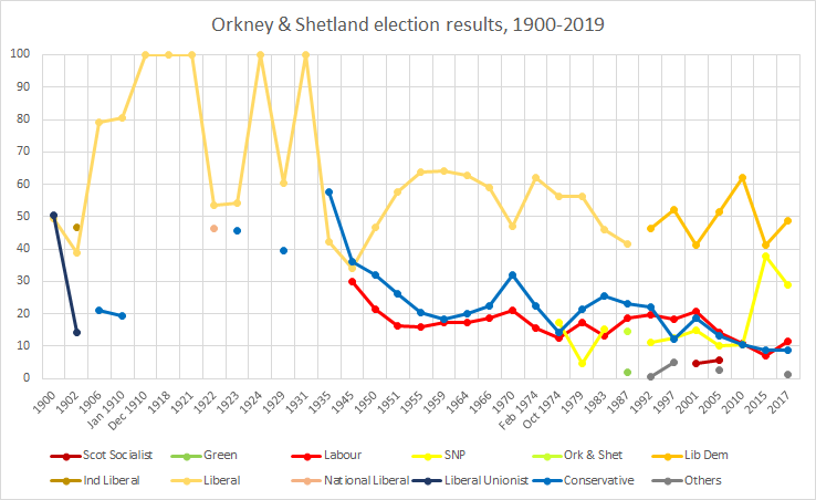
Orkney and Shetland is a constituency of the House of Commons of the Parliament of the United Kingdom. It elects one Member of Parliament (MP) by the first past the post system of election. In the Scottish Parliament, Orkney and Shetland are separate constituencies. The constituency was historically known as Orkney and Zetland (an alternative name for Shetland). In the 2014 Scottish independence referendum, 65.4% of the constituency's electors voted for Scotland to stay part of the United Kingdom. Creation The British parliamentary constituency was created in 1708 following the Acts of Union, 1707 and replaced the former Parliament of Scotland shire constituency of Orkney & Zetland. Boundaries The constituency is made up of the two northernmost island groups of Scotland, Orkney and Shetland. A constituency of this name has existed continuously since 1708. However, before 1918 the town of Kirkwall (the capital of Orkney) formed part of the Northern Burghs constituency. It i ... [...More Info...] [...Related Items...] OR: [Wikipedia] [Google] [Baidu] |
Orkney (Scottish Parliament Constituency)
Orkney is a constituency of the Scottish Parliament ( Holyrood) covering the council area of Orkney. It elects one Member of the Scottish Parliament (MSP) by the first past the post method of election. It is also one of eight constituencies in the Highlands and Islands electoral region, which elects seven additional members, in addition to the eight constituency MSPs, to produce a form of proportional representation for the region as a whole. Orkney has been held by the Liberal Democrats at all elections since the formation of the Scottish Parliament in 1999, with the current MSP being Liam McArthur, who won the seat at the 2007 Scottish Parliament election. The former Deputy First Minister Jim Wallace represented the constituency from 1999 to 2007. Electoral region Orkney is part of the Highlands and Islands electoral region; the other seven constituencies of are Argyll and Bute, Caithness, Sutherland and Ross, Inverness and Nairn, Moray, Na h-Eileanan an Iar, Shet ... [...More Info...] [...Related Items...] OR: [Wikipedia] [Google] [Baidu] |
Orkney Islands
Orkney (; sco, Orkney; on, Orkneyjar; nrn, Orknøjar), also known as the Orkney Islands, is an archipelago in the Northern Isles of Scotland, situated off the north coast of the island of Great Britain. Orkney is 10 miles (16 km) north of the coast of Caithness and has about 70 islands, of which 20 are inhabited. The largest island, the Mainland, has an area of , making it the sixth-largest Scottish island and the tenth-largest island in the British Isles. Orkney’s largest settlement, and also its administrative centre, is Kirkwall. Orkney is one of the 32 council areas of Scotland, as well as a constituency of the Scottish Parliament, a lieutenancy area, and an historic county. The local council is Orkney Islands Council, one of only three councils in Scotland with a majority of elected members who are independents. The islands have been inhabited for at least years, originally occupied by Mesolithic and Neolithic tribes and then by the Picts. Orkney was col ... [...More Info...] [...Related Items...] OR: [Wikipedia] [Google] [Baidu] |
A986 Road (Great Britain)
List of A roads in zone 9 in Great Britain starting north of the A8, east of the A9 (roads beginning with 9). Single- and double-digit roads Triple-digit roads Four-digit roads See also * B roads in Zone 9 of the Great Britain numbering scheme * List of motorways in the United Kingdom This list of motorways in the United Kingdom is a complete list of motorways in the United Kingdom. Note that the numbering scheme used for Great Britain does not include roads in Northern Ireland, which are allocated numbers on an ad hoc basis ... * Transport in Aberdeen#Roads * Transport in Edinburgh#Road network * Transport in Scotland#Road References {{UK road lists 9 ... [...More Info...] [...Related Items...] OR: [Wikipedia] [Google] [Baidu] |
Bronze Age
The Bronze Age is a historic period, lasting approximately from 3300 BC to 1200 BC, characterized by the use of bronze, the presence of writing in some areas, and other early features of urban civilization. The Bronze Age is the second principal period of the three-age system proposed in 1836 by Christian Jürgensen Thomsen for classifying and studying ancient societies and history. An ancient civilization is deemed to be part of the Bronze Age because it either produced bronze by smelting its own copper and alloying it with tin, arsenic, or other metals, or traded other items for bronze from production areas elsewhere. Bronze is harder and more durable than the other metals available at the time, allowing Bronze Age civilizations to gain a technological advantage. While terrestrial iron is naturally abundant, the higher temperature required for smelting, , in addition to the greater difficulty of working with the metal, placed it out of reach of common use until the end o ... [...More Info...] [...Related Items...] OR: [Wikipedia] [Google] [Baidu] |
Knowes Of Trotty
The Knowes of Trotty is a Bronze Age cemetery located in Mainland, Orkney in Scotland. The ancient site consists of a group of twelve surviving burial mounds (or barrows), dating to 2030–1770 BC. Along with cremated human remains, four gold discs and a number of amber beads and pendants were discovered in the largest mound in 1858. Knowes of Trotty is one of the earliest group of burial mounds in Orkney and one of the largest Bronze Age cemeteries in the United Kingdom. Description The site The Knowes of Trotty Bronze Age burial site is located east of the Loch of Harray, in Mainland, Orkney. Twelve burial mounds are situated at the bottom of the western slopes of the Ward of Redland. The mounds are laid out in two rows, and range in diameter from , and in height from in height. The largest mound, is at the north end of the group and is in diameter, in height, and sits on an elevated platform. The barrows were originally surrounded by a stone cairn which was then covered i ... [...More Info...] [...Related Items...] OR: [Wikipedia] [Google] [Baidu] |
Gazetteer For Scotland
The ''Gazetteer for Scotland'' is a gazetteer covering the geography, history and people of Scotland. It was conceived in 1995 by Bruce Gittings of the University of Edinburgh and David Munro of the Royal Scottish Geographical Society, and contains 25,870 entries as of July 2019. It claims to be "the largest dedicated Scottish resource created for the web". The Gazetteer for Scotland provides a carefully researched and editorially validated resource widely used by students, researchers, tourists and family historians with interests in Scotland. Following on from a strong Scottish tradition of geographical publishing, the ''Gazetteer for Scotland'' is the first comprehensive gazetteer to be produced for the country since Francis Groome's ''Ordnance Gazetteer of Scotland'' (1882-6) (the text of which is incorporated into relevant entries). The aim is not to produce a travel guide, of which there are many, but to write a substantive and thoroughly edited description of the count ... [...More Info...] [...Related Items...] OR: [Wikipedia] [Google] [Baidu] |
Prehistoric Scotland
Archaeology and geology continue to reveal the secrets of prehistoric Scotland, uncovering a complex past before the Romans brought Scotland into the scope of recorded history. Successive human cultures tended to be spread across Europe or further afield, but focusing on this particular geographical area sheds light on the origin of the widespread remains and monuments in Scotland, and on the background to the history of Scotland. The extent of open countryside untouched by intensive farming, together with past availability of stone rather than timber, has given Scotland a wealth of accessible sites where the ancient past can be seen. The remote prehistory of Scotland Scotland is geologically alien to Europe, comprising a sliver of the ancient continent of Laurentia (which later formed the bulk of North America). During the Cambrian period the crustal region which became Scotland formed part of the continental shelf of Laurentia, then still south of the equator. Laurentia was s ... [...More Info...] [...Related Items...] OR: [Wikipedia] [Google] [Baidu] |
Liddle Burnt Mound
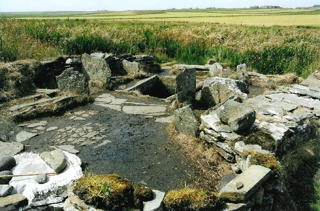
Liddle Burnt Mound is a Bronze Age site on the island of South Ronaldsay, Orkney. The site consists of the remains of a building and a mound that surrounds it on three sides.Hedges 1985, p. 17 The purpose of the site is controversial, but most investigators believe burnt mounds hosted a "domestic function", perhaps related to cooking. Description The Liddle Burnt Mound is located on Liddle Farm; the farmer, Ronald Simison, had been using the mound as a quarry for road metal until he came across stone structures in 1972.Ritchie 1995, p. 94 He alerted Colin Renfrew who was excavating at Quanterness. John Hedges, a member of his team, investigated the site and recognized the remains of a stone building at the centre of the mound. The building is oval with thick external walls. From these, interior walls project into the main room creating compartments, one of which houses a hearth. In the centre of the structure is a large recessed, stone tank, lined with flagstones and rendered wa ... [...More Info...] [...Related Items...] OR: [Wikipedia] [Google] [Baidu] |


