|
Bhaupur, Kanpur
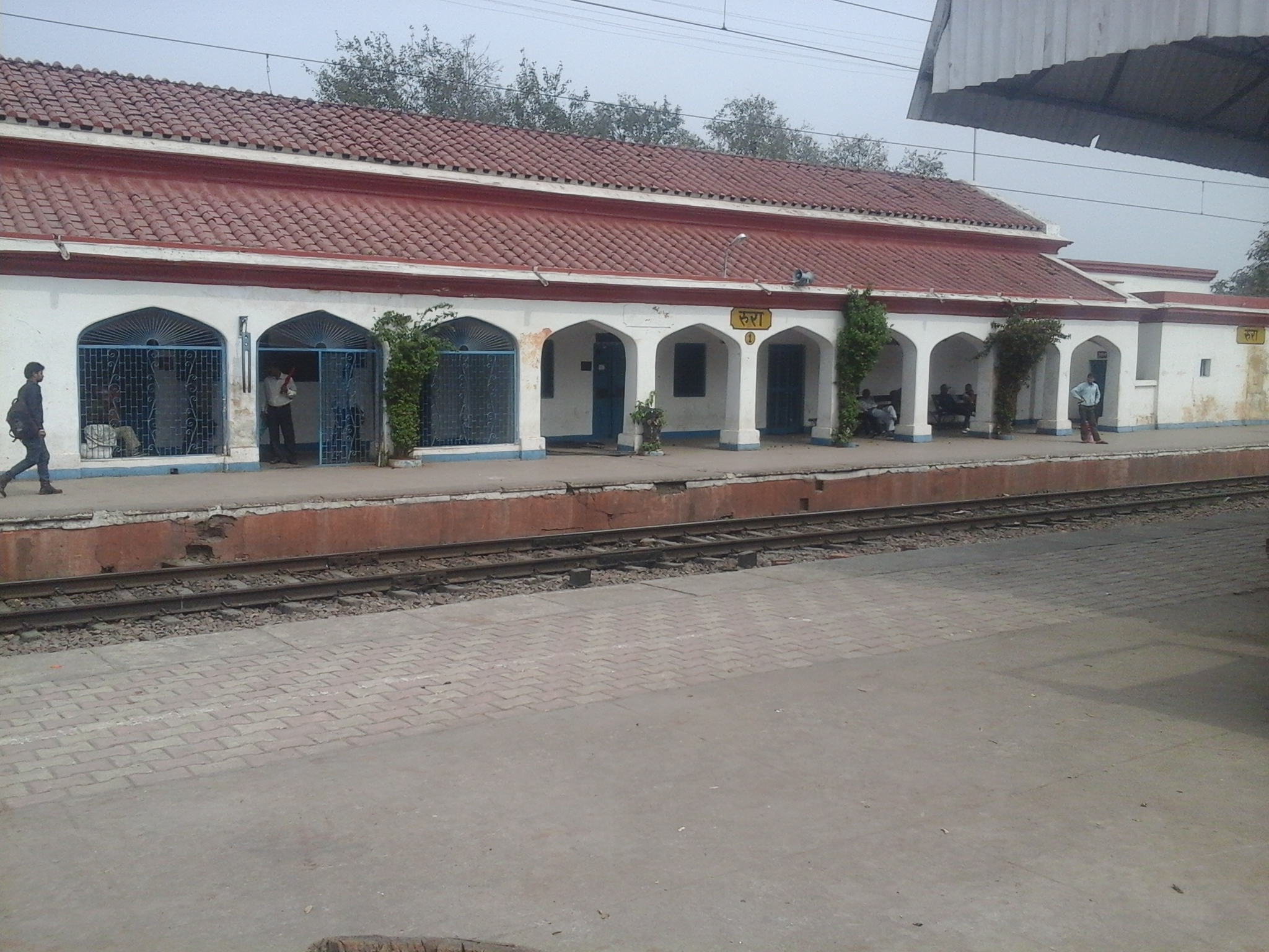
Bhaupur is a town in Kanpur Dehat district in the state of Uttar Pradesh, India.With World Bank funding development of Bhaupur Industrial Sector UPSIDC Amritsar-Kolkata dedicated freight corridor is being carried out. It is located in Maitha development block of Akbarpur tehsil. Nearby villages are Ranjitpur, Bhadhpur, Bhool, Dharmangadpur, Naubasta, Pratappur, Raipalpur, Rasatpur, pachehara and Surar Transport Bhaupur is well connected by road and rail. Bhaupur Railway Station is on the Agra-Kanpur rail route. Kanpur-Etawah passenger and Kanpur-Tundla Passenger are among the main trains that pass through this station. To the east, Panki Station (11 km) is the nearest Station. Going west, Maitha (10 km) is the next station. Kanpur Central Railway Station is the nearest major railway station. Station Code is: BPU Nearest International Airport is Amausi Airport or Chaudhary Charan Singh International Airport (IATA: LKO, ICAO: VILK) having regular scheduled flig ... [...More Info...] [...Related Items...] OR: [Wikipedia] [Google] [Baidu] |
Bhaupur Railway Station Nameplate
Bhaupur may refer to: * Bhaupur, Kanpur Bhaupur is a town in Kanpur Dehat district in the state of Uttar Pradesh, India.With World Bank funding development of Bhaupur Industrial Sector UPSIDC Amritsar-Kolkata dedicated freight corridor is being carried out. It is located in Maitha d ... * Bhaupur, Ambedkar Nagar {{disambig ... [...More Info...] [...Related Items...] OR: [Wikipedia] [Google] [Baidu] |
Kanpur Dehat District
Kanpur Dehat district is a district in Uttar Pradesh state in northern India. The administrative headquarters of the district are at Mati- Akbarpur. This district is part of Kanpur division. Kanpur was formerly spelled Cawnpore. History The site of the Battle of Madarpur, fought between the Bhumihar zamindars and the Mughal Empire in 1528CE took place within the present-day Kanpur Dehat district. Kanpur District was divided into two districts, namely Kanpur Nagar and Kanpur Dehat in year 1977. The two were reunited again in 1979 and again separated in 1981. Uttar Pradesh government decided to rename Kanpur Dehat district as Ramabai Nagar district on 1 July 2010. In July 2012, it was returned to Kanpur Dehat. Tehsils in Kanpur Dehat district # Akbarpur # Bhognipur # Derapur #Rasulabad #Sikandara #Maitha Political representatives Legislative Council Legislative Assembly Parliamentary constituencies Transport The district is well connected by railways. Three rail t ... [...More Info...] [...Related Items...] OR: [Wikipedia] [Google] [Baidu] |
Uttar Pradesh
Uttar Pradesh (; , 'Northern Province') is a state in northern India. With over 200 million inhabitants, it is the most populated state in India as well as the most populous country subdivision in the world. It was established in 1950 after India had become a republic. It was a successor to the United Provinces (UP) during the period of the Dominion of India (1947–1950), which in turn was a successor to the United Provinces (UP) established in 1935, and eventually of the United Provinces of Agra and Oudh established in 1902 during the British Raj. The state is divided into 18 divisions and 75 districts, with the state capital being Lucknow, and Prayagraj serving as the judicial capital. On 9 November 2000, a new state, Uttaranchal (now Uttarakhand), was created from Uttar Pradesh's western Himalayan hill region. The two major rivers of the state, the Ganges and its tributary Yamuna, meet at the Triveni Sangam in Prayagraj, a Hindu pilgrimage site. Ot ... [...More Info...] [...Related Items...] OR: [Wikipedia] [Google] [Baidu] |
India
India, officially the Republic of India (Hindi: ), is a country in South Asia. It is the seventh-largest country by area, the second-most populous country, and the most populous democracy in the world. Bounded by the Indian Ocean on the south, the Arabian Sea on the southwest, and the Bay of Bengal on the southeast, it shares land borders with Pakistan to the west; China, Nepal, and Bhutan to the north; and Bangladesh and Myanmar to the east. In the Indian Ocean, India is in the vicinity of Sri Lanka and the Maldives; its Andaman and Nicobar Islands share a maritime border with Thailand, Myanmar, and Indonesia. Modern humans arrived on the Indian subcontinent from Africa no later than 55,000 years ago., "Y-Chromosome and Mt-DNA data support the colonization of South Asia by modern humans originating in Africa. ... Coalescence dates for most non-European populations average to between 73–55 ka.", "Modern human beings—''Homo sapiens''—originated in Africa. Then, int ... [...More Info...] [...Related Items...] OR: [Wikipedia] [Google] [Baidu] |
UP State Industrial Development Corporation
Uttar Pradesh State Industrial Development Authority (UPSIDA), formerly UP State Industrial Development Corporation, is a corporation of Government of Uttar Pradesh, which promotes industries and develops industrial infrastructure in the State. Its industrial areas are equipped with infrastructure facilities likes roads, drains, internal power lines, street lights, etc. Corporation has developed 159 Industrial areas (including Uttarakhand) and 23 residential areas encompassing 41948 acres of land with a wide range of infrastructure facilities. The Corporation comes under the Department of Infrastructure and Industrial Development of the Government of Uttar Pradesh. History UPSIDC was incorporated as a company limited by shares on 29 March 1961. Its authorized capital is ₹40 crores and paid-up share capital is ₹24,07,51,000 as on March, 2015. It is one of the six infrastructure sector State Public sector enterprises, other five being, Uttar Pradesh State Bridge Corporati ... [...More Info...] [...Related Items...] OR: [Wikipedia] [Google] [Baidu] |
Amritsar
Amritsar (), historically also known as Rāmdāspur and colloquially as ''Ambarsar'', is the second largest city in the Indian state of Punjab, after Ludhiana. It is a major cultural, transportation and economic centre, located in the Majha region of Punjab. The city is the administrative headquarters of the Amritsar district. According to the United Nations, as of 2018, Amritsar is the second-most populous city in Punjab and the most populous metropolitan region in the state with a population of roughly 2 million. Amritsar is the centre of the Amritsar Metropolitan Region. According to the 2011 census, the population of Amritsar was 1,989,961. It is one of the ten Municipal Corporations in the state, and Karamjit Singh Rintu is the current Mayor of the city. The city is situated north-west of Chandigarh, 455 km (283 miles) north-west of New Delhi, and 47 km (29.2 miles) north-east of Lahore, Pakistan, with the Indo-Pak Border (Attari-Wagah) being only away. Am ... [...More Info...] [...Related Items...] OR: [Wikipedia] [Google] [Baidu] |
Kolkata
Kolkata (, or , ; also known as Calcutta , the official name until 2001) is the capital of the Indian state of West Bengal, on the eastern bank of the Hooghly River west of the border with Bangladesh. It is the primary business, commercial, and financial hub of Eastern India and the main port of communication for North-East India. According to the 2011 Indian census, Kolkata is the seventh-most populous city in India, with a population of 45 lakh (4.5 million) residents within the city limits, and a population of over 1.41 crore (14.1 million) residents in the Kolkata Metropolitan Area. It is the third-most populous metropolitan area in India. In 2021, the Kolkata metropolitan area crossed 1.5 crore (15 million) registered voters. The Port of Kolkata is India's oldest operating port and its sole major riverine port. Kolkata is regarded as the cultural capital of India. Kolkata is the second largest Bengali-speaking city after Dhaka ... [...More Info...] [...Related Items...] OR: [Wikipedia] [Google] [Baidu] |
Maitha
Maitha is a village in Kanpur Dehat district in the state of Uttar Pradesh, India.Maitha is founded new tehsil in Kanpur Dehat district and comes under Kanpur Metropolitan Area Maitha Village Maitha village is situated from Maitha Railway Station towards north -east at a distance 10 kilometer. maitha is block.most popular birth place of swami baskranand saraswati and his temple & mata sumbaha devi temple. Maitha Railway Station In the name of Maitha is a Railway Station on the route North Central Railway between Kanpur Central and Etawah. The passengers trains are available here towards east to Kanpur and towards west to Etawah Etawah also known as Ishtikapuri is a city on the banks of Yamuna River in the state of Western Uttar Pradesh in India. It is the administrative headquarters of Etawah District. Etawah's population of 256,838 (as per 2011 population census) m .... There is also a settlement near Maitha Railway Station. It has shops, schools, petrol pump and s ... [...More Info...] [...Related Items...] OR: [Wikipedia] [Google] [Baidu] |
Akbarpur, Ramabai Nagar
Akbarpur is a town in Kanpur Dehat district in the state of Uttar Pradesh, India. Demographics India census, Akbarpur had a population of 17,368. Males constitute 53% of the population and females 47%. Akbarpur has an average literacy rate of 57%, lower than the national average of 59.5%; with 58% of the males and 42% of females literate. 18% of the population is under 6 years of age. Connectivity Railways Akbarpur is not Railway station but it is connected with Rura (NCR) Railway station. Rura is connected with express &super fast trains to Delhi, Howrah, Lucknow.Agra, Patna, Meerut, Jammu etc. Rura is a main Railway Station of Akbarpur, (Kanpur Dehat) . Another mini railway station is Lalpur. Airways Kanpur Airport is nearest airport. Roadways Golden Quadrilateral National Highway 19 (India) passes through Akbarpur city District Kanpur Dehat. Which is connected to all major cities of India. Lucknow-Jhansi another National High Way passes through its. A C, non A C & Sle ... [...More Info...] [...Related Items...] OR: [Wikipedia] [Google] [Baidu] |
Bhaupur Railway Station
Bhaupur may refer to: * Bhaupur, Kanpur Bhaupur is a town in Kanpur Dehat district in the state of Uttar Pradesh, India.With World Bank funding development of Bhaupur Industrial Sector UPSIDC Amritsar-Kolkata dedicated freight corridor is being carried out. It is located in Maitha d ... * Bhaupur, Ambedkar Nagar {{disambig ... [...More Info...] [...Related Items...] OR: [Wikipedia] [Google] [Baidu] |
Amausi Airport
Chaudhary Charan Singh International Airport is an international airport serving Lucknow, the capital of the Indian state of Uttar Pradesh. It is located in the Amausi area of the city 14 km far from the city centre, and was earlier also known as ''Amausi International Airport''. It was later renamed in 2008 after Chaudhary Charan Singh, the fifth prime minister of India. It is owned and operated by the Lucknow International Airport Limited (LIAL), a public–private consortium led by Adani Group. CCSIA is the 11th busiest airport in terms of passenger traffic in India. It handled around 2.5 million passengers, with 22,954 aircraft movement in the fiscal year 2020–2021 and handled around 5.5 million passengers, with 38,494 aircraft movement in the fiscal year 2019–2020. Due to an air travel ban during the global COVID-19 pandemic, passenger traffic declined by 55.1% in the year 2020-2021 and aircraft movements by 40.4% in the same year. The airport has two operatio ... [...More Info...] [...Related Items...] OR: [Wikipedia] [Google] [Baidu] |
Kanpur Chakeri
Chakeri is a census town in Kanpur metropolitan area, situated about 16 kilometres east of Kanpur city in the state of Uttar Pradesh, India. It is an industrial town with textiles and food products as its major productions. Chakeri Airforce Station, North India's second largest Airforce base is situated here. Chakeri also has reputed educational institutions and colleges. Central Leather Research Institute, the only government leather research institute in North India is situated here. Grand Trunk Road made by the great emperor Sher Shah Suri passes from Chakeri. The town is enlisted as a Town Area of Kanpur metropolitan area. Demographics Chakeri has population of 7,526 of which 3,803 are males while 3,723 are females as per report released by Census India 2011. Population of Children with age of 0-6 is 1116 which is 14.83% of total population of Chakeri (CT). In Chakeri Census Town, Female Sex Ratio is of 979 against state average of 912. Moreover, Child Sex Ratio in Chake ... [...More Info...] [...Related Items...] OR: [Wikipedia] [Google] [Baidu] |


