|
Bergenwood, North Bergen
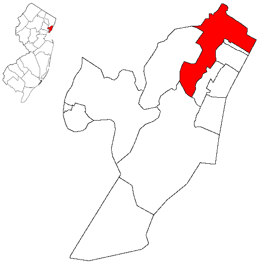
Bergenwood is a long narrow district of North Bergen, New Jersey in the northern central part of the township between Kennedy Boulevard and Tonnelle Avenue, characterized by the steep slopes on the west side of the Hudson Palisades as they descend to the New Jersey Meadowlands. Topography Bergenwood is the North Bergen district in which the township's distinction of being the U.S. municipality with the second-most hills, behind only San Francisco, is most evident. The unusual topography also makes for another oddity. The north-south streets in Bergenwood (and on much of the western slope of North Bergen) keep their names (Newkirk, Durham, Liberty, Columbia, and Grand among them) but often do not run contiguously. In some cases they are broken up into seven or eight sections. (Addresses are taken from the numbered east-west streets which more or less follow the urban grid of North Hudson municipalities.) Built form Bergenwood is a dense residential area of mostly two-family ho ... [...More Info...] [...Related Items...] OR: [Wikipedia] [Google] [Baidu] |
New Durham, North Bergen
New Durham is a neighborhood in North Bergen Township in Hudson County, New Jersey, United States. It is located near the foot of Union Turnpike and Bergen Turnpike, and south of the Tonnelle Avenue Station of the Hudson Bergen Light Rail. It is one of the few residential areas along the otherwise industrial/commercial Tonnelle Ave, and site of one of the town's main post offices. The area was the site of the colonial American community centered on the Three Pigeons when most of North Hudson was called Bergen Woods, a name recalled in Bergenwood Section on the steep slopes of the west side of the Hudson Palisades. Bergen Turnpike was one of the plank roads Hackensack Plank Road, crossing the Bergen Hill and the Hackensack Meadows that joined the village at Bergen Square with that at Hackenack that had been made the county seat of then much larger Bergen County in 1710. A congregation, established in the 1800s, still uses the name for their church. New Durham was a statio ... [...More Info...] [...Related Items...] OR: [Wikipedia] [Google] [Baidu] |
List Of Neighborhoods In North Bergen, New Jersey
The following is a list of neighborhoods in North Bergen, New Jersey. * Bergenline runs to Nungesser's at the Fairview border near North Hudson Park. *Bigleys/Three Ditches-a wetlands area between the Northeast Corridor and Secaucus Road. * Racetrack Section-between Bergenline and Kennedy Boulevard on the palisades plateau * Bergenwood, on the steep slopes of the west side of the Palisades * New Durham site of colonial American Three Pigeons near the Bergen Turnpike and Tonnelle Avenue *Meadowview, behind the Municipal Building between the many cemeteries: ** Flower Hill Cemetery, Hoboken Cemetery, and Weehawken Cemetery * Bulls Ferry on the Hudson Waterfront, site of Roc Harbor, Palisades Medical Center and Hudson River Waterfront Walkway *Babbitt from the rail station near North Bergen Yard in Meadowlands * Woodcliff on the Hudson Palisades around North Hudson Park * Transfer Station near the single point border Union City and Jersey City near Paterson Plank Road, K ... [...More Info...] [...Related Items...] OR: [Wikipedia] [Google] [Baidu] |
Hackensack, New Jersey
Hackensack is a city in and the county seat of Bergen County, New Jersey, United States.New Jersey County Map New Jersey Department of State. Accessed July 10, 2017. The area was officially named New Barbadoes Township until 1921, but has informally been known as Hackensack since at least the 18th century. As of the , the city's population was 46,030. An [...More Info...] [...Related Items...] OR: [Wikipedia] [Google] [Baidu] |
Bergen Square
Bergen Square, at the intersection of Bergen Avenue and Academy Street in Jersey City, is in the southwestern part of the much larger Journal Square district. A commercial residential area, it contains an eclectic array of architectural styles including 19th-century row houses, Art Deco retail and office buildings, and is the site of the longest continually-used school site in the United States.There has been a school at the northeast corner of Bergen Square since 1664. See Nearby are the Van Wagenen House (sometimes called the Apple Tree House) and Old Bergen Church, two structures from the colonial period. St. George & St. Shenouda Coptic Orthodox Church founded by early Egyptian immigrants was one of the original Coptic congregations in New Jersey. History The square and the streets around it are the site of what is considered to be the oldest municipality in the state of New Jersey which was first established in 1660 as Bergen in the province of New Netherland and, i ... [...More Info...] [...Related Items...] OR: [Wikipedia] [Google] [Baidu] |
Bergen County
Bergen County is the most populous county in the U.S. state of New Jersey.Annual Estimates of the Resident Population: April 1, 2010 to July 1, 2018 - 2018 Population Estimates , . Accessed May 17, 2019. As of the , the county's population was 955,732, an increase of 50,616 (5.6%) from the 905,116 residents in the [...More Info...] [...Related Items...] OR: [Wikipedia] [Google] [Baidu] |
Maisland
Maisland, or Mais Land, was an area in Hudson County, New Jersey. Location The region of Maisland was located on the western slope of the Hudson Palisades. Under the governorship of Philip Carteret, land in the region of Bergen was sold under the name the "New Mais Land" on May 12, 1668. A Dutch settler named Caspar Stienmets, the judge for court in Bergen, purchased the town lot which amounted to nearly , which included meadowlands and woodlands. The official proceeding allotted the area in the statement: The township of Bergen was divided into several road districts by the freeholders of the Bergen, with the purpose to better regulate the local highway systems. What arose from the annual meeting was the creation of several districts, which remain today somewhat as distinct neighborhoods or cities; some of which were Bergen Woods, Bulls Ferry, Sekakes and Wehauk along with Maisland, and upon the freeholders' decision, an overseer for each district was appointed. The area ... [...More Info...] [...Related Items...] OR: [Wikipedia] [Google] [Baidu] |
Jersey City Heights
The Heights or Jersey City Heights is a district in the north end of Jersey City, New Jersey, atop the New Jersey Palisades overlooking Hoboken to the east and Croxton in the Meadowlands to the west. The southern border of The Heights is generally considered to be north of Bergen Arches and The Divided Highway, while Paterson Plank Road in Washington Park near Transfer Station is its main northern boundary. Its postal area ZIP code is 07307. Neighborhoods and thoroughfares Central Avenue is The Heights' primary commercial thoroughfare, with more than 240 businesses serving the area. Pershing Field (named for General John J Pershing is a memorial park in the center of the district that was built on a military training ground. It offers a green space, baseball fields, a swimming pool and ice-skating rink. The adjacent Jersey City Reservoir No. 3 has been preserved as a state designated wetland and park. Many stately Victorian and Edwardian homes distinguish the Heights ... [...More Info...] [...Related Items...] OR: [Wikipedia] [Google] [Baidu] |
Bergen County, New Jersey
Bergen County is the most populous county in the U.S. state of New Jersey.Annual Estimates of the Resident Population: April 1, 2010 to July 1, 2018 - 2018 Population Estimates , United States Census Bureau. Accessed May 17, 2019. As of the , the county's population was 955,732, an increase of 50,616 (5.6%) from the 905,116 residents in the [...More Info...] [...Related Items...] OR: [Wikipedia] [Google] [Baidu] |
Fairview Cemetery (Westfield, New Jersey)
Fairview Cemetery & Arboretum is a cemetery and accredited arboretum in Westfield, New Jersey. It is a member of the American Public Gardens Association. The cemetery was founded in 1868 and is 105 acres. It is "non-sectarian, non-profit organization, owned and operated solely for the benefit of its Property Owners." Notable burials * Virginia Apgar (1909–1974), founder of Neonatology and the Apgar score *Charles Newell Fowler (1922–1989) *Whitney Houston (1963–2012), her daughter Bobbi Kristina Brown (1993–2015) and her father John Russell Houston, Jr. (1920–2003) *1971 murder victims of John Emil List (Frederick List, Helen List, Patricia List, John Jr. List) *Claydes Charles Smith (1948–2006), co-founder of Kool & the Gang *William Miller Sperry (1839–1927), namesake of the William Miller Sperry Observatory and brother of Thomas Sperry. * Joshua Bryant (law enforcement) (1852–1898) was Cranford, New Jersey's first African-Am ... [...More Info...] [...Related Items...] OR: [Wikipedia] [Google] [Baidu] |
Machpelah Cemetery, North Bergen
The Machpelah Cemetery, also spelled as "Macpelah Cemetery", or "Macphelah Cemetery", is a cemetery in Hudson County, New Jersey. Location Machpelah Cemetery is located at 5810 Tonnelle Avenue, in North Bergen, New Jersey. It is one of several burial sites along the western slope of the Hudson Palisades, which rise to the east above sea-level, including the adjacent Hoboken Cemetery, and nearby Grove Church Cemetery, Weehawken Cemetery, and Flower Hill Cemetery, which together constitute a string of green open spaces in North Hudson County. The entrance is just north of the Tonnelle Avenue terminus of the Hudson Bergen Light Rail. History Name Machpelah is a name given to numerous cemeteries in the United States. The Cave of the Patriarchs or the Cave of Machpelah (Hebrew: מערת המכפלה, ''Me'arat HaMachpela'', Trans. "Doubled Cave") is a cave-within-a-cave located in Hebron, Israel, that Biblical tradition ascribes the status of the burial tomb for Abraham, ... [...More Info...] [...Related Items...] OR: [Wikipedia] [Google] [Baidu] |
Grove Church Cemetery
The Grove Church Cemetery is a nonsectarian cemetery,Brooklyn Fairchild Sons, p. 63. located on the western slope of the Hudson Palisades, along with several other cemeteries in a string of green open space, in Hudson County, New Jersey, United States. The Grove Church, who owns the cemetery, is one of the oldest religious bodies in the area, and it has had an operating cemetery since 1847. Throughout its history, prominent families have been buried there, as well as American Civil war veterans. There have also been reports of vandalism and misuse of the property since the 19th century, and in 2007 some of the cemetery grounds were occupied by the homeless. Location Grove Church Cemetery is located at 1132 46th Street in North Bergen, New Jersey. The cemetery also fronts Kennedy Boulevard which in the 19th century was known as Dallytown Road, or Bergenwood Road. Overlooking into the Secaucus, it starts at the top and extends onto the middle of the western face of the ... [...More Info...] [...Related Items...] OR: [Wikipedia] [Google] [Baidu] |


