|
Bemaraha Nature Reserve
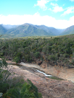
Tsingy de Bemaraha Strict Nature Reserve is a nature reserve located near the western coast of Madagascar in Melaky Region at . The area was listed as a UNESCO World Heritage Site in 1990 due to the unique geography, preserved mangrove forests, and wild bird and lemur populations. National Park The southern end of the protected area has subsequently been changed into the Tsingy de Bemaraha National Park, covering . The northern end of the protected area remains as a strict nature reserve (Réserve Naturelle Intégrale) covering . It is characterised by needle-shaped limestone formations, above cliffs over the Manambolo River. The incredibly sharp limestone formations can cut through equipment and flesh easily, which makes traversing them extremely difficult. The word "Tsingy" is derived from a local word meaning "the place where one cannot walk barefoot". Tourism Tourists can access the national park by road from Morondava, a town 150 km south of the park. Limit ... [...More Info...] [...Related Items...] OR: [Wikipedia] [Google] [Baidu] |
World Heritage Committee
The World Heritage Committee selects the sites to be listed as UNESCO World Heritage Sites, including the World Heritage List and the List of World Heritage in Danger, defines the use of the World Heritage Fund and allocates financial assistance upon requests from States Parties. It comprises representatives from 21 state parties that are elected by the General Assembly of States Parties for a four-year term. These parties vote on decisions and proposals related to the World Heritage Convention and World Heritage List. According to the World Heritage Convention, a committee member's term of office is six years. However many State's Parties choose to voluntarily limit their term to four years, in order to give other States Parties an opportunity to serve. All members elected at the 15th General Assembly (2005) voluntarily chose to reduce their term of office from six to four years. Deliberations of the World Heritage Committee are aided by three advisory bodies, the IUCN, ICOMO ... [...More Info...] [...Related Items...] OR: [Wikipedia] [Google] [Baidu] |
Tsingy De Bemaraha
Tsingy de Bemaraha Strict Nature Reserve is a nature reserve located near the western coast of Madagascar in Melaky Region at . The area was listed as a UNESCO World Heritage Site in 1990 due to the unique geography, preserved mangrove forests, and wild bird and lemur populations. National Park The southern end of the protected area has subsequently been changed into the Tsingy de Bemaraha National Park, covering . The northern end of the protected area remains as a strict nature reserve (Réserve Naturelle Intégrale) covering . It is characterised by needle-shaped limestone formations, above cliffs over the Manambolo River. The incredibly sharp limestone formations can cut through equipment and flesh easily, which makes traversing them extremely difficult. The word "Tsingy" is derived from a local word meaning "the place where one cannot walk barefoot". Tourism Tourists can access the national park by road from Morondava, a town 150 km south of the park. Limited access ... [...More Info...] [...Related Items...] OR: [Wikipedia] [Google] [Baidu] |
Geography Of Madagascar
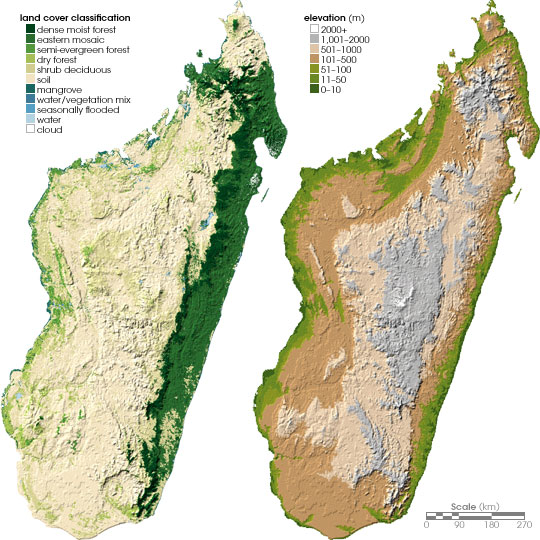
Madagascar is a large island in the Indian Ocean off the eastern coast of southern Africa, east of Mozambique. It has a total area of with of land and of water. Madagascar is the fourth largest island and the 2nd largest island country in the world. The highest point is Maromokotro, in the Tsaratanana Massif region in the north of the island, at . The capital Antananarivo is in the Central Highlands near the centre of the island. It has the 25th largest Exclusive Economic Zone of . Madagascar is 400 kilometres (250 miles) east of mainland Africa. Geographical regions Madagascar can be divided into five general geographical regions: the east coast, the Tsaratanana Massif, the Central Highlands, the west coast, and the southwest. The highest elevations parallel the east coast. The total size is , which makes it the world's second largest island country. East coast The east coast consists of a narrow band of lowlands about fifty kilometers wide, formed from the sedimentatio ... [...More Info...] [...Related Items...] OR: [Wikipedia] [Google] [Baidu] |
National Parks Of Madagascar
This list of national parks of Madagascar includes all officially recognized protected areas as of 2015. The protected areas network of Madagascar is managed by the Madagascar National Parks Association (PNM-ANGAP). The network includes three types of protected areas: Strict Nature Reserves (IUCN category Ia), National Parks (IUCN category II) and Wildlife Reserves (IUCN category IV). At the 2003 IUCN World Parks Congress in Durban, the Malagasy President, Marc Ravalomanana, announced an initiative to more than triple the area under protection from approximately to over (from 3% to 10% of Madagascar's area). This "Durban Vision", as it has been dubbed, involved broadening the definition of protected areas in the country and legislation has been passed to allow the creation of four new categories of protected area: Natural Parks (IUCN category II), Natural Monuments (IUCN category III), Protected Landscapes (IUCN category V), and Natural Resource Reserves (IUCN category VI). As we ... [...More Info...] [...Related Items...] OR: [Wikipedia] [Google] [Baidu] |

