|
Bellarine Rail Trail
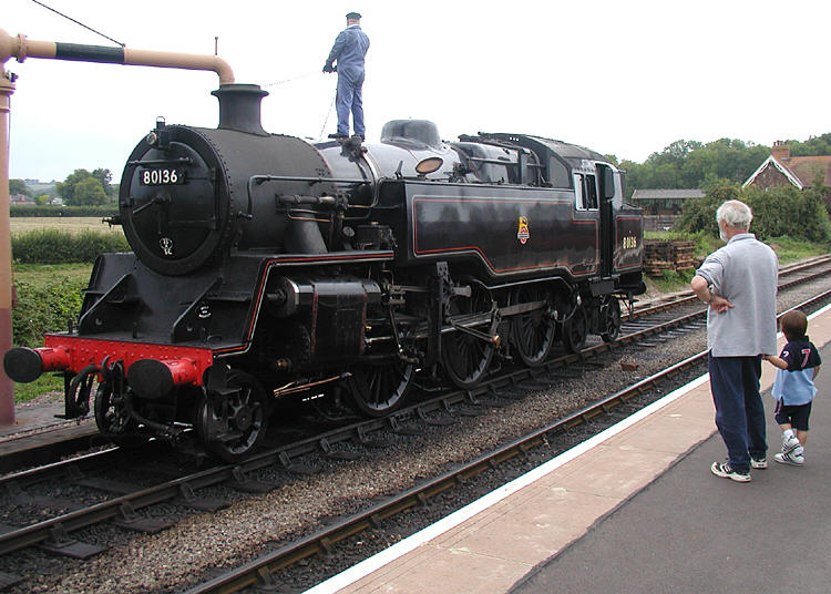
The Bellarine Rail Trail is a 32 km walking and cycling track on the Bellarine Peninsula, in Victoria, Australia, that follows the route of the former South Geelong to Queenscliff branch line. It runs from South Geelong to Queenscliff, passing through the towns of Leopold, Curlewis and Drysdale. The rails have been removed from the western section between South Geelong and Drysdale. Sections of the rail trail between South Geelong Station and the Bellarine Highway, and Melaluka Rd, through Leopold and Curlewis to Drysdale are sealed to provide a quality surface in high traffic areas. the surrounding reserves feature areas of remnant, indigenous vegetation, creating an interesting, safe and tranquil environment for users. The Bellarine Railway operates a tourist railway between Drysdale and Queenscliff, and the walking track runs parallel to the railway in this 16 km eastern section. The route traverses farmland with scattered patches and strips of native vegeta ... [...More Info...] [...Related Items...] OR: [Wikipedia] [Google] [Baidu] |
Bellarine Rail Trail Start-finish In Queenscliff, 05
The Bellarine Peninsula (Wathawurrung: ''Balla-wein'' or ''Biteyong'') is a peninsula located south-west of Melbourne in Victoria, Australia, surrounded by Port Phillip, Corio Bay and Bass Strait. The peninsula, together with the Mornington Peninsula, separates Port Phillip Bay from Bass Strait. The peninsula itself was originally occupied by Indigenous Australian clans of the Wathaurong nation, prior to European settlement in the early 19th century. Early European settlements were initially centred on wheat and grain agriculture, before the area became a popular tourist destination with most visitors arriving by paddle steamer on Port Phillip in the late 19th century. Today, approximately 55,000 people live on the peninsula and unlike its cousin, the |
Tourist Railway
A heritage railway or heritage railroad (US usage) is a railway operated as living history to re-create or preserve railway scenes of the past. Heritage railways are often old railway lines preserved in a state depicting a period (or periods) in the history of rail transport. Definition The British Office of Rail and Road defines heritage railways as follows:...'lines of local interest', museum railways or tourist railways that have retained or assumed the character and appearance and operating practices of railways of former times. Several lines that operate in isolation provide genuine transport facilities, providing community links. Most lines constitute tourist or educational attractions in their own right. Much of the rolling stock and other equipment used on these systems is original and is of historic value in its own right. Many systems aim to replicate both the look and operating practices of historic former railways companies. Infrastructure Heritage railway lines ... [...More Info...] [...Related Items...] OR: [Wikipedia] [Google] [Baidu] |
Rail Trails In Victoria (Australia)
Rail or rails may refer to: Rail transport *Rail transport and related matters * Rail (rail transport) or railway lines, the running surface of a railway Arts and media Film * ''Rails'' (film), a 1929 Italian film by Mario Camerini * ''Rail'' (1967 film), a film by Geoffrey Jones for British Transport Films *'' Mirattu'' or ''Rail'', a Tamil-language film and its Telugu dub Magazines * ''Rail'' (magazine), a British rail transport periodical * ''Rails'' (magazine), a former New Zealand based rail transport periodical Other arts * The Rails, a British folk-rock band * Rail (theater) or batten, a pipe from which lighting, scenery, or curtains are hung Technology *Rails framework or Ruby on Rails, a web application framework *Rail system (firearms), a mounting system for firearm attachments *Front engine dragster *Runway alignment indicator lights, a configuration of an approach lighting system *Rule Augmented Interconnect Layout, a specification for expressing guidelines for p ... [...More Info...] [...Related Items...] OR: [Wikipedia] [Google] [Baidu] |
Ted Wilson Trail
The Ted Wilson trail is a 12 kilometre walking and cycling path in north west of Geelong, Victoria (Australia). The path trails along the Western ring road through the suburbs of Corio, Lovely Banks, Bell Post Hill and Hamlyn Heights. It was named in honour of Ted Wilson (former police sergeant and manager of the Bicycle Co-ordination Unit) for his contribution to cycling through the Barwon Regional Bicycle Council and the City of Greater Geelong’s bicycle strategy. Cycling Geelong run an annual memorial ride for Ted Wilson on the trail, providing a sprig of rosemary to participants. In 2014, the City of Greater Geelong started The Greenway Project which committed to planting over 60,000 trees and 20,000 shrubs and grasses by 2018 along the trail. External links Ted Wilson Trail - City of Greater GeelongThe Greenway projectTed Wilson Trail facebook See also * Cycling in Geelong Cycling in Geelong, Victoria is common for recreation and competition, but less so for ut ... [...More Info...] [...Related Items...] OR: [Wikipedia] [Google] [Baidu] |
Cycling In Geelong
Cycling in Geelong, Victoria is common for recreation and competition, but less so for utility and commuting. Geelong has a discontinuous network of off-road trails and on-road bicycle lanes. Geelong's major shared riding and walking trails are the Bellarine Rail Trail, Barwon river, Bay, Ted Wilson and Waurn Ponds creek trails. A series of rider fatalities and the safety of bike riding in and around Geelong has received media and political attention. A 2016 announcement of plans for a two-way separated bike lane in central Geelong was welcomed by bike groups. History The Geelong Cycling Club (formerly the Geelong West Cycling Club) started in 1911. In 1977 efforts were made to improve cycling in Geelong with Australia's first bike plan launched by Hubert Opperman. The plan's credo was that "''every street is a cycling street''". The plan was also widely recognised at the time as a model for bicycle planning. As a result of the plan, a recreational cycling group called t ... [...More Info...] [...Related Items...] OR: [Wikipedia] [Google] [Baidu] |
Bellarine Rail Trail Map Stevage
The Bellarine Peninsula (Wathawurrung: ''Balla-wein'' or ''Biteyong'') is a peninsula located south-west of Melbourne in Victoria, Australia, surrounded by Port Phillip, Corio Bay and Bass Strait. The peninsula, together with the Mornington Peninsula, separates Port Phillip Bay from Bass Strait. The peninsula itself was originally occupied by Indigenous Australian clans of the Wathaurong nation, prior to European settlement in the early 19th century. Early European settlements were initially centred on wheat and grain agriculture, before the area became a popular tourist destination with most visitors arriving by paddle steamer on Port Phillip in the late 19th century. Today, approximately 55,000 people live on the peninsula and unlike its cousin, the |
Woodland
A woodland () is, in the broad sense, land covered with trees, or in a narrow sense, synonymous with wood (or in the U.S., the ''plurale tantum'' woods), a low-density forest forming open habitats with plenty of sunlight and limited shade (see differences between British, American, and Australian English explained below). Woodlands may support an understory of shrubs and herbaceous plants including grasses. Woodland may form a transition to shrubland under drier conditions or during early stages of primary or secondary succession. Higher-density areas of trees with a largely closed canopy that provides extensive and nearly continuous shade are often referred to as forests. Extensive efforts by conservationist groups have been made to preserve woodlands from urbanization and agriculture. For example, the woodlands of Northwest Indiana have been preserved as part of the Indiana Dunes. Definitions United Kingdom ''Woodland'' is used in British woodland management to mean tre ... [...More Info...] [...Related Items...] OR: [Wikipedia] [Google] [Baidu] |
Eucalypt
Eucalypt is a descriptive name for woody plants with capsule fruiting bodies belonging to seven closely related genera (of the tribe Eucalypteae) found across Australasia: ''Eucalyptus'', '' Corymbia'', '' Angophora'', ''Stockwellia'', ''Allosyncarpia'', ''Eucalyptopsis'' and ''Arillastrum''. Taxonomy For an example of changing historical perspectives, in 1991, largely genetic evidence indicated that some prominent ''Eucalyptus'' species were actually more closely related to ''Angophora'' than to other eucalypts; they were accordingly split off into the new genus ''Corymbia''. Although separate, all of these genera and their species are allied and it remains the standard to refer to the members of all seven genera ''Angophora'', ''Corymbia'', ''Eucalyptus'', ''Stockwellia'', ''Allosyncarpia'', ''Eucalyptopsis'' and ''Arillastrum'' as "eucalypts" or as the eucalypt group. The extant genera ''Stockwellia'', ''Allosyncarpia'', ''Eucalyptopsis'' and ''Arillastrum'' comprise six k ... [...More Info...] [...Related Items...] OR: [Wikipedia] [Google] [Baidu] |
Arable Land
Arable land (from the la, arabilis, "able to be ploughed") is any land capable of being ploughed and used to grow crops.''Oxford English Dictionary'', "arable, ''adj''. and ''n.''" Oxford University Press (Oxford), 2013. Alternatively, for the purposes of agricultural statistics, the term often has a more precise definition: A more concise definition appearing in the Eurostat glossary similarly refers to actual rather than potential uses: "land worked (ploughed or tilled) regularly, generally under a system of crop rotation". In Britain, arable land has traditionally been contrasted with pasturable land such as heaths, which could be used for sheep-rearing but not as farmland. Arable land area According to the Food and Agriculture Organization of the United Nations, in 2013, the world's arable land amounted to 1.407 billion hectares, out of a total of 4.924 billion hectares of land used for agriculture. Arable land (hectares per person) Non-arable land ... [...More Info...] [...Related Items...] OR: [Wikipedia] [Google] [Baidu] |
Bellarine Railway
The Bellarine Railway, formerly the Bellarine Peninsula Railway, is a volunteer-operated steam-driven tourist railway located in Victoria, Australia. It operates on a 16 km section of a formerly disused branch line on the Bellarine Peninsula between the coastal town of Queenscliff and Drysdale, near Geelong. History as a working railway The original line was commissioned in September 1878, and opened on 21 May 1879. It connected Queenscliff with South Geelong station, the terminus of the Geelong line, and the junction of the Warrnambool line. It was acknowledged at the time that although passenger traffic alone might not justify a railway line, military traffic from both the port and Fort Queenscliff—a key defence installation—would warrant its construction. It initially carried passenger, goods and military traffic, and continued to do so for several decades. In the first few months of operation, it carried only one service per day, but at its peak, in January ... [...More Info...] [...Related Items...] OR: [Wikipedia] [Google] [Baidu] |
Drysdale, Victoria
Drysdale is a rural township near Geelong, Victoria, Australia, located on the Bellarine Peninsula. The town has an approximate population of over 3,700. Drysdale forms part of an urban area, along with nearby Clifton Springs, Victoria, Clifton Springs, that had an estimated population of 13,494 Estimated resident population, 30 June 2016. at June 2016. The town is named after Anne Drysdale whose estate "Coriyule" still sits above the township. The area was formerly known as McLeod's Waterholes and Bellarine. A township began to develop in the late 1840s and a Post Office (known as Bellarine until 1862) opened on 1 January 1855. From 1902 until 1951 Murrudoc Post Office to the west operated in the area also known as Murradoc. The railway reached the Drysdale railway station, local railway station from South Geelong on the way to Queenscliff in 1879, and remained in Victorian Railways service until 1976. It is now the western terminus of the tourist orientated Bellarine Railway. T ... [...More Info...] [...Related Items...] OR: [Wikipedia] [Google] [Baidu] |


