|
Beit Amin
Beit Amin ( ar, بيت أمين) is a Palestinian village in the Qalqilya Governorate in the western West Bank, located south of Qalqilya. According to the Palestinian Central Bureau of Statistics, the village had a population of approximately 1,147 inhabitants in 2006. Location Beit Amin is located 8.35km south-east of Qalqiliya. It is bordered by Sanniriya to the east, ''Al Mudawwar'' and ''‘Izbat al Ashqar'' to the south, ''‘Izbat Salman'' to the west, and ‘Azzun ‘Atma to the north. History In 1882 the PEF's ''Survey of Western Palestine'' noted ''Khurbet Beit Yemin'' (under "Archæology"): "Walls, cisterns and rock-cut tomb." British Mandate The village passed to British control they defeated the Ottoman Empire in World War 1. The village was administered under the British Mandate for Palestine until 1948. Jordanian Era In the wake of the 1948 Arab–Israeli War, and after the 1949 Armistice Agreements, Beit Amin came under Jordanian rule. Post-1967 Since the ... [...More Info...] [...Related Items...] OR: [Wikipedia] [Google] [Baidu] |
Arabic Script
The Arabic script is the writing system used for Arabic and several other languages of Asia and Africa. It is the second-most widely used writing system in the world by number of countries using it or a script directly derived from it, and the third-most by number of users (after the Latin and Chinese scripts). The script was first used to write texts in Arabic, most notably the Quran, the holy book of Islam. With the religion's spread, it came to be used as the primary script for many language families, leading to the addition of new letters and other symbols. Such languages still using it are: Persian (Farsi/Dari), Malay ( Jawi), Uyghur, Kurdish, Punjabi (Shahmukhi), Sindhi, Balti, Balochi, Pashto, Lurish, Urdu, Kashmiri, Rohingya, Somali and Mandinka, Mooré among others. Until the 16th century, it was also used for some Spanish texts, and—prior to the language reform in 1928—it was the writing system of Turkish. The script is written from right to left in a cu ... [...More Info...] [...Related Items...] OR: [Wikipedia] [Google] [Baidu] |
World War I
World War I (28 July 1914 11 November 1918), often abbreviated as WWI, was one of the deadliest global conflicts in history. Belligerents included much of Europe, the Russian Empire, the United States, and the Ottoman Empire, with fighting occurring throughout Europe, the Middle East, Africa, the Pacific, and parts of Asia. An estimated 9 million soldiers were killed in combat, plus another 23 million wounded, while 5 million civilians died as a result of military action, hunger, and disease. Millions more died in genocides within the Ottoman Empire and in the 1918 influenza pandemic, which was exacerbated by the movement of combatants during the war. Prior to 1914, the European great powers were divided between the Triple Entente (comprising France, Russia, and Britain) and the Triple Alliance (containing Germany, Austria-Hungary, and Italy). Tensions in the Balkans came to a head on 28 June 1914, following the assassination of Archduke Franz Ferdin ... [...More Info...] [...Related Items...] OR: [Wikipedia] [Google] [Baidu] |
Israeli West Bank Barrier
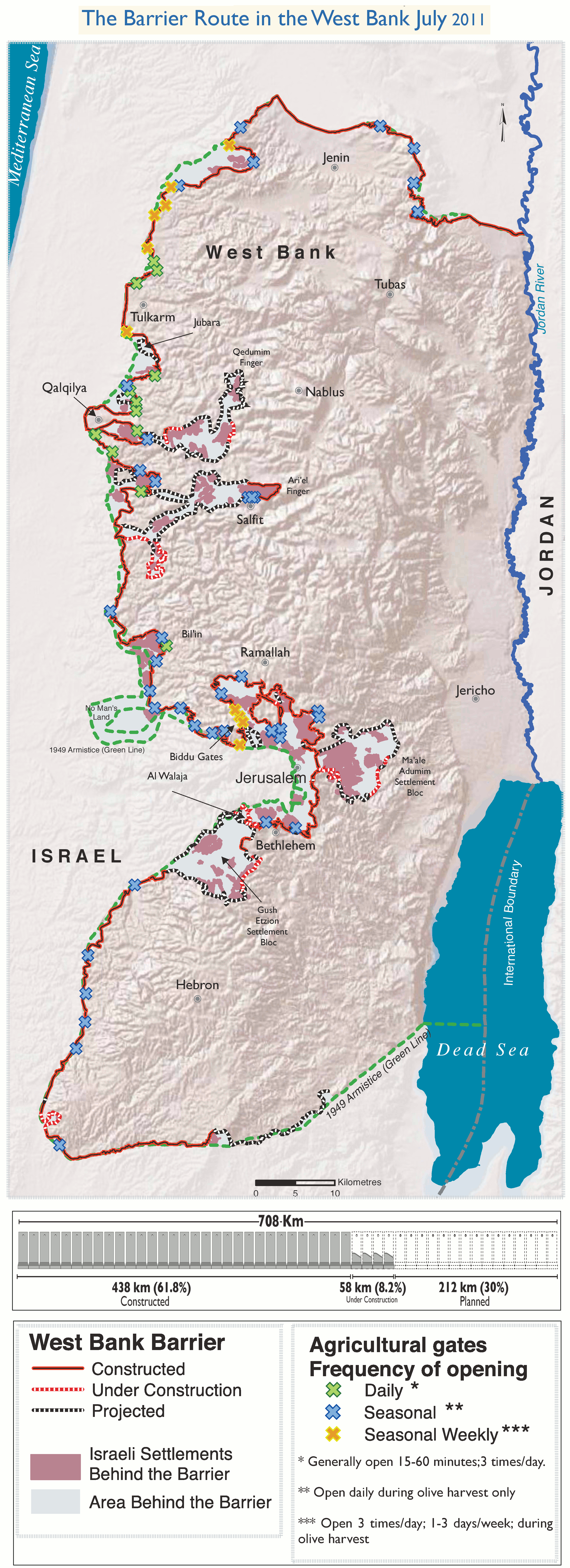
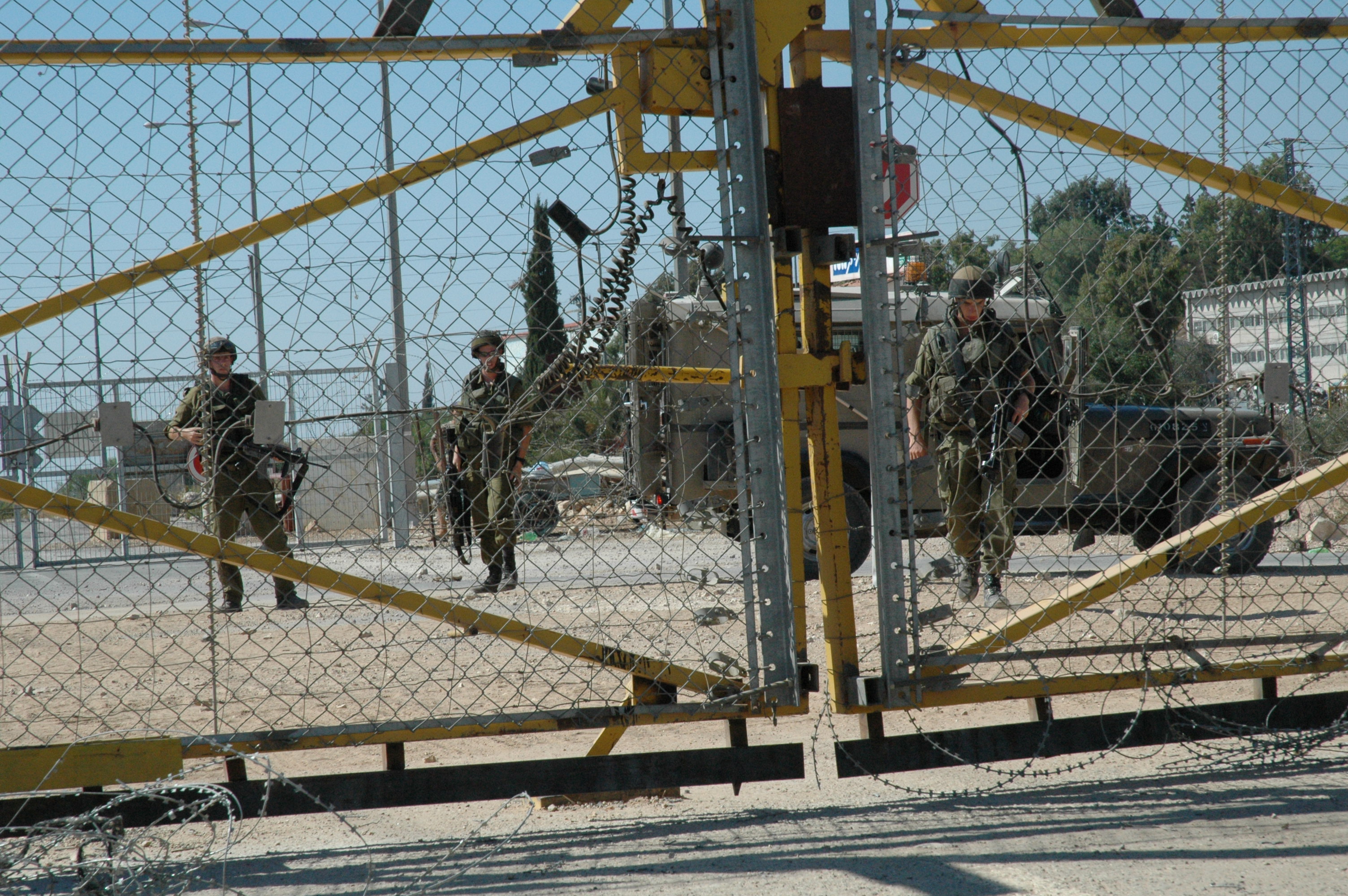
The Israeli West Bank barrier, comprising the West Bank Wall and the West Bank fence, is a separation barrier built by Israel along the Green Line and inside parts of the West Bank. It is a contentious element of the Israeli–Palestinian conflict: Israel describes the wall as a necessary security barrier against Palestinian terrorism, whereas Palestinians describe it as an element of racial segregation and a representation of Israeli apartheid. At a total length of upon completion, the route traced by the barrier is more than double the length of the Green Line, with 15% of its length running along the Green Line or inside Israel, and the remaining 85% running as much as inside the West Bank, effectively isolating about 9% of the land and approximately 25,000 Palestinians from the rest of the Palestinian territory. The barrier was built by Israel following a wave of Palestinian political violence and incidents of terrorism inside Israel during the Second Intifada, which ... [...More Info...] [...Related Items...] OR: [Wikipedia] [Google] [Baidu] |
Shi'ar Tikvah
Sha'arei Tikva ( he, שַׁעֲרֵי תִּקְוָה, ''lit.'' Gates of Hope) is an Israeli settlement in the West Bank at an elevation of 200 metres. Located northeast of Rosh HaAyin and one kilometre east of the Green Line near Elkana, it is organised as a community settlement and falls under the jurisdiction of Shomron Regional Council. It had a population of around 6,000 as of January 2017. The international community considers Israeli settlements in the West Bank illegal under international law, but the Israeli government disputes this. History According to ARIJ, Israel confiscated land from three nearby Palestinian villages in order to construct Sha'arei Tikva: *the largest part were taken from Azzun Atma, which lost 2,689 dunums to Sha'arei Tikva and Oranit, *8 dunams were taken from Mas-ha, *3 dunums were taken from Beit Amin Beit Amin ( ar, بيت أمين) is a Palestinian village in the Qalqilya Governorate in the western West Bank, located south of Qalqilya. Ac ... [...More Info...] [...Related Items...] OR: [Wikipedia] [Google] [Baidu] |
Israeli Settlement
Israeli settlements, or Israeli colonies, are civilian communities inhabited by Israeli citizens, overwhelmingly of Jewish ethnicity, built on lands occupied by Israel in the 1967 Six-Day War. The international community considers Israeli settlements to be illegal under international law, though Israel disputes this. Israeli settlements currently exist in the West Bank (including East Jerusalem), claimed by the State of Palestine as its sovereign territory, and in the Golan Heights, widely viewed as Syrian territory. East Jerusalem and the Golan Heights have been effectively annexed by Israel, though the international community has rejected any change of status in both territories and continues to consider each occupied territory. Although the West Bank settlements are on land administered under Israeli military rule rather than civil law, Israeli civil law is "pipelined" into the settlements, such that Israeli citizens living there are treated similarly to those livi ... [...More Info...] [...Related Items...] OR: [Wikipedia] [Google] [Baidu] |
Mas-ha
Mas-ha ( ar, مسحة) is a Palestinian village located in the Salfit Governorate in the northern West Bank, 24 kilometers southwest of Nablus. According to the Palestinian Central Bureau of Statistics, it had a population of 2,003 in 2007. increasing slightly in the 1931 census to 87 Muslims in a total of 20 houses. In the 1945 statistics the population was 110, all Muslims, while the total land area was 8,263 dunams, according to an official land and population survey. Of this, 1,612 were allocated for plantations and irrigable land, 2,482 for cereals, while 18 dunams were classified as built-up (urban) areas. File:Biddya 1941.jpg, Mas-ha 1941 1:20,000 File:Biddya 1945.jpg, Mas-ha 1945 1:250,000 Jordanian era In the wake of the 1948 Arab–Israeli War, and after the 1949 Armistice Agreements, Mas-ha came under Jordanian rule. In 1961, the population was 478. Post-1967 Since the Six-Day War in 1967, Mas-ha has been under Israeli occupation. In the early 2000s, there wer ... [...More Info...] [...Related Items...] OR: [Wikipedia] [Google] [Baidu] |
Area C (West Bank)
Area C ( he, שטח C; ar, منطقة ج) is an West Bank Areas in the Oslo II Accord, Oslo II administrative division of the West Bank, defined as "areas of the West Bank outside West_Bank_Areas_in_the_Oslo_II_Accord#Area_B, Areas A and B". Area C constitutes about 61 percent of the West Bank territory; the area was committed in 1995 under West_Bank_Areas_in_the_Oslo_II_Accord, the Oslo II Accord to be "gradually transferred to Palestinian jurisdiction" (with an option for land swaps under a final agreement), but such transfer did not happen. Area C (excluding East Jerusalem), which along with Area B is under Israeli military control since June 1967, is home to roughly 400,000 Israeli settlers, and approximately 300,000 Palestinians; who live in more than 500 residential areas located partially or fully in Area C. The Jewish population in Area C is administered by the Israeli Judea and Samaria Area administration, whereas the Palestinian population is directly administered by ... [...More Info...] [...Related Items...] OR: [Wikipedia] [Google] [Baidu] |
Area B
The Palestinian enclaves are areas in the West Bank designated for Palestinians under a variety of Israeli–Palestinian peace process, U.S. and Israeli-led proposals to end the Israeli-Palestinian conflict. The enclaves are Israel and apartheid, often compared to the Bantustans, nominally self-governing black homelands created in apartheid-era South Africa, and are therefore referred to as bantustans. They have been referred to figuratively as the Palestinian archipelago, among other terms. The "islands" first took official form as Areas A and B under the 1995 Oslo II Accord. This arrangement was explicitly intended to be temporary with Area C (West Bank), Area C (the rest of the West Bank) to "be gradually transferred to Palestinian jurisdiction" by 1997; however, no such transfers were made. The area of the West Bank currently under partial civil control of the Palestinian National Authority is composed of 165 "islands". The creation of this arrangement has been described by ... [...More Info...] [...Related Items...] OR: [Wikipedia] [Google] [Baidu] |
Oslo II Accord
The Interim Agreement on the West Bank and the Gaza Strip commonly known as Oslo II or Oslo 2, was a key and complex agreement in the Israeli–Palestinian peace process. Because Oslo II was signed in Taba, Egypt, Taba, it is sometimes called the Taba Agreement. The Oslo Accords envisioned the establishment of a Palestinian interim self-government in the Palestinian territories. Oslo II created the West Bank Areas in the Oslo II Accord, Areas A, B and C in the West Bank. The Palestinian National Authority, Palestinian Authority was given some limited powers and responsibilities in the Areas A and B and a prospect of negotiations on a final settlement based on Security Council Resolutions 242 and 338. The Accord was officially signed on 28 September 1995. Historical context The Oslo II Accord was first signed in Taba (Egypt), Taba (in the Sinai Peninsula, Egypt) by Israel and the PLO on 24 September 1995 and then four days later on 28 September 1995 by Israeli Prime Minister Yitz ... [...More Info...] [...Related Items...] OR: [Wikipedia] [Google] [Baidu] |
Israeli Occupation Of The West Bank
The Israeli occupation of the West Bank began on 7 June 1967, when Israeli forces captured and occupied the territory (including East Jerusalem), then occupied by Jordan, during the Six-Day War, and continues to the present day. The status of the West Bank as a militarily occupied territory has been affirmed by the International Court of Justice and, with the exception of East Jerusalem, by the Israeli Supreme Court. The official view of the Israeli government is that the laws of belligerent occupation do not apply to the territories, which it claims are "disputed", and it administers the West Bank, excepting East Jerusalem, under the Israeli Civil Administration, a branch of the Israeli Ministry of Defense. Considered to be a classic example of an "intractable" conflict, the length of Israel's occupation was already regarded as exceptional after two decades, and is now the longest in modern history. Israel has cited several reasons for retaining the West Bank within its am ... [...More Info...] [...Related Items...] OR: [Wikipedia] [Google] [Baidu] |
Six-Day War
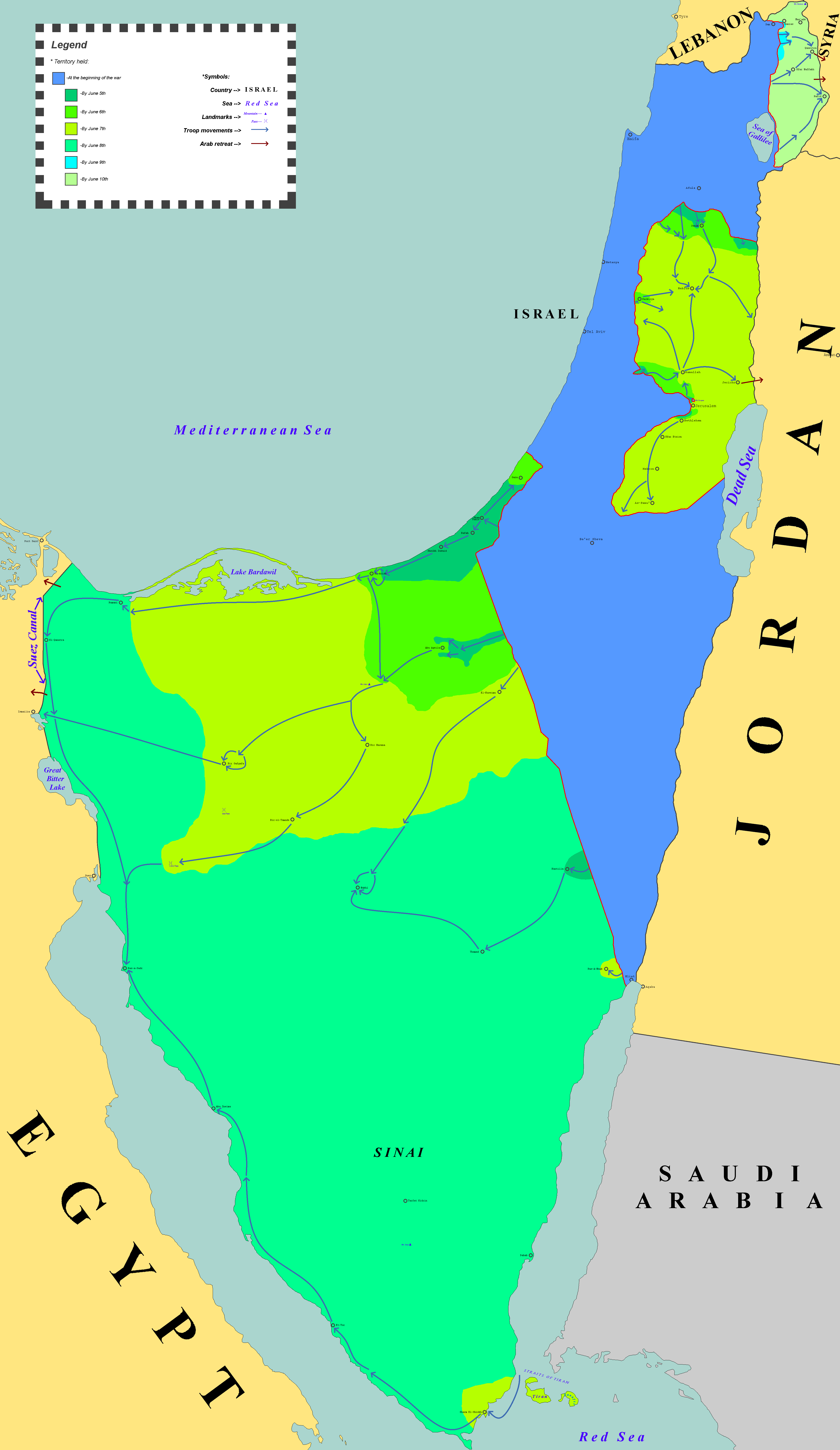
The Six-Day War (, ; ar, النكسة, , or ) or June War, also known as the 1967 Arab–Israeli War or Third Arab–Israeli War, was fought between Israel and a coalition of Arab world, Arab states (primarily United Arab Republic, Egypt, Syria, and Jordan) from 5 to 10 June 1967. Escalated hostilities broke out amid poor relations between Israel and its Arab neighbours following the 1949 Armistice Agreements, which were signed at the end of the 1948 Arab–Israeli War, First Arab–Israeli War. Earlier, in 1956, regional tensions over the Straits of Tiran escalated in what became known as the Suez Crisis, when Israel invaded Egypt over the Israeli passage through the Suez Canal and Straits of Tiran, Egyptian closure of maritime passageways to Israeli shipping, ultimately resulting in the re-opening of the Straits of Tiran to Israel as well as the deployment of the United Nations Emergency Force (UNEF) along the Borders of Israel#Border with Egypt, Egypt–Israel border. In ... [...More Info...] [...Related Items...] OR: [Wikipedia] [Google] [Baidu] |
Jordanian Annexation Of The West Bank
The Jordanian annexation of the West Bank formally occurred on 24 April 1950, after the 1948 Arab–Israeli War, during which Transjordan occupied territory that had previously been part of Mandatory PalestineRaphael Israeli, Jerusalem divided: the armistice regime, 1947–1967, Volume 23 of Cass series – Israeli history, politics, and society, Psychology Press, 2002, p. 23. and had been earmarked by the UN General Assembly Resolution 181 of 29 November 1947 for an independent Arab state to be established there alongside a Jewish state mainly to its west. The annexation tripled the population of Transjordan, from 400,000 to 1,300,000, and the country became a dualistic society with the Palestinian and Transjordanian communities remaining distinct. During the war, Jordan's Arab Legion took control of territory on the western side of the Jordan River, including the cities of Jericho, Bethlehem, Hebron, Nablus and eastern Jerusalem, including the Old City. Following th ... [...More Info...] [...Related Items...] OR: [Wikipedia] [Google] [Baidu] |


