|
Becquerel (Martian Crater)
Becquerel is a 167 km-diameter crater at 22.1°N, 352.0°E on Mars, in Arabia Terra in Oxia Palus quadrangle. It is named after Antoine H. Becquerel. Photographs by the Mars Global Surveyor revealed layered sedimentary rocks in the crater. The layers appear to be only a few meters thick and show little variations in thickness. Recent studies with HiRISE have determined the exact thickness of the layers. The 66 layers measured showed one group of layers to average and another group to average in thickness. Patterns like this are usually produced on Earth through the effects of water; volcanic deposits would not produce ash or laval flows of such regular thickness and in any event, there are no nearby volcanic vents. There are cyclic variations in the thickness of the exposed sedimentary layers, possibly indicating cyclic variations in environmental conditions while the sediment was being laid down. Most of the layers are parallel to each other, suggesting they formed by ... [...More Info...] [...Related Items...] OR: [Wikipedia] [Google] [Baidu] |
Viking Program
The ''Viking'' program consisted of a pair of identical American space probes, ''Viking 1'' and ''Viking 2'', which landed on Mars in 1976. Each spacecraft was composed of two main parts: an orbiter designed to photograph the surface of Mars from orbit, and a lander designed to study the planet from the surface. The orbiters also served as communication relays for the landers once they touched down. The Viking program grew from NASA's earlier, even more ambitious, Voyager Mars program, which was not related to the successful Voyager deep space probes of the late 1970s. ''Viking 1'' was launched on August 20, 1975, and the second craft, ''Viking 2'', was launched on September 9, 1975, both riding atop Titan IIIE rockets with Centaur upper stages. ''Viking 1'' entered Mars orbit on June 19, 1976, with ''Viking 2'' following on August 7. After orbiting Mars for more than a month and returning images used for landing site selection, the orbiters and landers detached; the lander ... [...More Info...] [...Related Items...] OR: [Wikipedia] [Google] [Baidu] |
Mars Reconnaissance Orbiter
''Mars Reconnaissance Orbiter'' (MRO) is a spacecraft designed to study the geology and climate of Mars, provide reconnaissance of future landing sites, and relay data from surface missions back to Earth. It was launched on August 12, 2005, and reached Mars on March 10, 2006. In November 2006, after five months of aerobraking, it entered its final science orbit and began its primary science phase. The cost to develop and operate MRO through the end of its prime mission in 2010 was . The spacecraft continues to operate at Mars, far beyond its intended design life. Due to its critical role as a high-speed data-relay for ground missions, NASA intends to continue the mission as long as possible, at least through the late 2020s. Pre-launch After the twin failures of the ''Mars Climate Orbiter'' and the Mars Polar Lander missions in 1999, NASA reorganized and replanned its Mars Exploration Program. In October 2000, NASA announced its reformulated Mars plans, which reduced the numb ... [...More Info...] [...Related Items...] OR: [Wikipedia] [Google] [Baidu] |
Water On Mars
Almost all water on Mars today exists as ice, though it also exists in small quantities as vapor in the atmosphere. What was thought to be low-volume liquid brines in shallow Martian soil, also called recurrent slope lineae, may be grains of flowing sand and dust slipping downhill to make dark streaks.Recurring Martian Streaks: Flowing Sand, Not Water? Nasa.org 2017-11-20 The only place where water ice is visible at the surface is at the north polar ice cap. Abundant water ice is also present beneath the permanent |
Planetary Nomenclature
Planetary nomenclature, like terrestrial nomenclature, is a system of uniquely identifying features on the surface of a planet or natural satellite so that the features can be easily located, described, and discussed. Since the invention of the telescope, astronomers have given names to the surface features they have discerned, especially on the Moon and Mars. To found an authority on planetary nomenclature, the International Astronomical Union (IAU) was organized in 1919 to designate and standardize names for features on Solar System bodies. How names are approved by the IAU When images are first obtained of the surface of a planet or satellite, a theme for naming features is chosen and a few important features are named, usually by members of the appropriate IAU task group (a commonly accepted planet-naming group). Later, as higher resolution images and maps become available, additional features are named at the request of investigators mapping or describing specific surfaces, ... [...More Info...] [...Related Items...] OR: [Wikipedia] [Google] [Baidu] |
Ore Resources On Mars
Mars may contain ores that would be very useful to colonization of Mars, potential colonists. The abundance of volcanic features together with widespread cratering are strong evidence for a variety of ores. While nothing may be found on Mars that would justify the high cost of transport to Earth, the more ores that future colonists can obtain from Mars, the easier it would be to build colonies there. How deposits are made Ore deposits are produced with the help of large amounts of heat. On Mars, heat can come from molten rock moving under the ground and from crater impacts. Liquid rock under the ground is called magma. When magma sits in underground chambers, slowly cooling over thousands of years, heavier elements sink. These elements, including copper, chromium, iron, and nickel become concentrated at the bottom. When magma is hot, many elements are free to move. As cooling proceeds, the elements bind with each other to form chemical compounds or minerals. Because some elemen ... [...More Info...] [...Related Items...] OR: [Wikipedia] [Google] [Baidu] |
List Of Craters On Mars
__NOTOC__ This is a list of craters on Mars. Impact craters on Mars larger than exist by the hundreds of thousands, but only about one thousand of them have names. Names are assigned by the International Astronomical Union after petitioning by relevant scientists, and in general, only craters that have a significant research interest are given names. Martian craters are named after famous scientists and science fiction authors, or if less than in diameter, after towns on Earth. Craters cannot be named for living people, and names for small craters are rarely intended to commemorate a specific town. Latitude and longitude are given as planetographic coordinates with west longitude. Catalog of named craters The catalog is divided into three partial lists: * List of craters on Mars: A–G * List of craters on Mars: H–N * List of craters on Mars: O–Z Names are grouped into tables for each letter of the alphabet, containing the crater's name (linked if article exists), co ... [...More Info...] [...Related Items...] OR: [Wikipedia] [Google] [Baidu] |
Impact Event
An impact event is a collision between astronomical objects causing measurable effects. Impact events have physical consequences and have been found to regularly occur in planetary systems, though the most frequent involve asteroids, comets or meteoroids and have minimal effect. When large objects impact terrestrial planets such as the Earth, there can be significant physical and biospheric consequences, though atmospheres mitigate many surface impacts through atmospheric entry. Impact craters and Impact structure, structures are dominant landforms on many of the Solar System's solid objects and present the strongest empirical evidence for their frequency and scale. Impact events appear to have played a significant role in the Formation and evolution of the Solar System, evolution of the Solar System since its formation. Major impact events have significantly shaped History of the Earth, Earth's history, and have been implicated in the giant impact theory, formation of the Earth� ... [...More Info...] [...Related Items...] OR: [Wikipedia] [Google] [Baidu] |
Groundwater On Mars
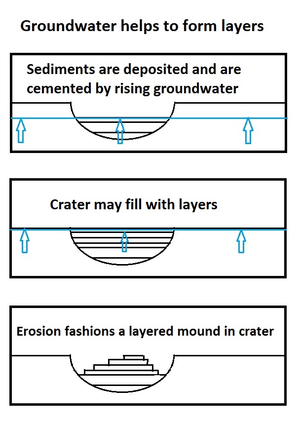
During past ages, there was rain and snow on Mars; especially in the Noachian and early Hesperian epochs. Some moisture entered the ground and formed aquifers. That is, the water went into the ground, seeped down until it reached a formation that would not allow it to penetrate further (such a layer is called impermeable). Water then accumulated forming a saturated layer. Deep aquifers may still exist. Overviews Researchers have found that Mars had a planet-wide groundwater system and several prominent features on the planet have been produced by the action of groundwater. When water rose to the surface or near the surface, various minerals were deposited and sediments became cemented together. Some of the minerals were sulfates that were probably produced when water dissolved sulfur from underground rocks, and then became oxidized when it came into contact with the air. While traveling through the aquifer, the water passed through igneous rock basalt, which would have contai ... [...More Info...] [...Related Items...] OR: [Wikipedia] [Google] [Baidu] |
Climate Of Mars
The climate of Mars has been a topic of scientific curiosity for centuries, in part because it is the only terrestrial planet whose surface can be directly observed in detail from the Earth with help from a telescope. Although Mars is smaller than the Earth, 11% of Earth's mass, and 50% farther from the Sun than the Earth, its climate has important similarities, such as the presence of polar ice caps, seasonal changes and observable weather patterns. It has attracted sustained study from planetologists and climatologists. While Mars' climate has similarities to Earth's, including periodic ice ages, there are also important differences, such as much lower thermal inertia. Mars' atmosphere has a scale height of approximately , 60% greater than that on Earth. The climate is of considerable relevance to the question of whether life is or ever has been present on the planet. The climate briefly received more interest in the news due to NASA measurements indicating increased sublima ... [...More Info...] [...Related Items...] OR: [Wikipedia] [Google] [Baidu] |
Areoid
The gravity of Mars is a natural phenomenon, due to the law of gravity, or gravitation, by which all things with mass around the planet Mars are brought towards it. It is weaker than Earth's gravity due to the planet's smaller mass. The average gravitational acceleration on Mars is 3.72076 ms−2 (about 38% of that of Earth) and it varies. In general, topography-controlled isostasy drives the short wavelength free-air gravity anomalies. At the same time, convective flow and finite strength of the mantle lead to long-wavelength planetary-scale free-air gravity anomalies over the entire planet. Variation in crustal thickness, magmatic and volcanic activities, impact-induced Moho-uplift, seasonal variation of polar ice caps, atmospheric mass variation and variation of porosity of the crust could also correlate to the lateral variations. Over the years models consisting of an increasing but limited number of spherical harmonics have been produced. Maps produced have included free ... [...More Info...] [...Related Items...] OR: [Wikipedia] [Google] [Baidu] |
Fault (geology)
In geology, a fault is a planar fracture or discontinuity in a volume of rock across which there has been significant displacement as a result of rock-mass movements. Large faults within Earth's crust result from the action of plate tectonic forces, with the largest forming the boundaries between the plates, such as the megathrust faults of subduction zones or transform faults. Energy release associated with rapid movement on active faults is the cause of most earthquakes. Faults may also displace slowly, by aseismic creep. A ''fault plane'' is the plane that represents the fracture surface of a fault. A ''fault trace'' or ''fault line'' is a place where the fault can be seen or mapped on the surface. A fault trace is also the line commonly plotted on geologic maps to represent a fault. A ''fault zone'' is a cluster of parallel faults. However, the term is also used for the zone of crushed rock along a single fault. Prolonged motion along closely spaced faults can blur the ... [...More Info...] [...Related Items...] OR: [Wikipedia] [Google] [Baidu] |
Opportunity (rover)
''Opportunity'', also known as MER-B (Mars Exploration Rover – B) or MER-1, is a robotic rover that was active on Mars from 2004 until 2018. ''Opportunity'' was operational on Mars for sols (). Launched on July 7, 2003, as part of NASA's Mars Exploration Rover program, it landed in Meridiani Planum on January 25, 2004, three weeks after its twin, ''Spirit'' (MER-A), touched down on the other side of the planet. With a planned 90- sol duration of activity (slightly less than 92.5 Earth days), ''Spirit'' functioned until it got stuck in 2009 and ceased communications in 2010, while ''Opportunity'' was able to stay operational for sols after landing, maintaining its power and key systems through continual recharging of its batteries using solar power, and hibernating during events such as dust storms to save power. This careful operation allowed ''Opportunity'' to operate for 57 times its designed lifespan, exceeding the initial plan by (in Earth time). By June 10, 2018, when ... [...More Info...] [...Related Items...] OR: [Wikipedia] [Google] [Baidu] |


