|
Bears Ears
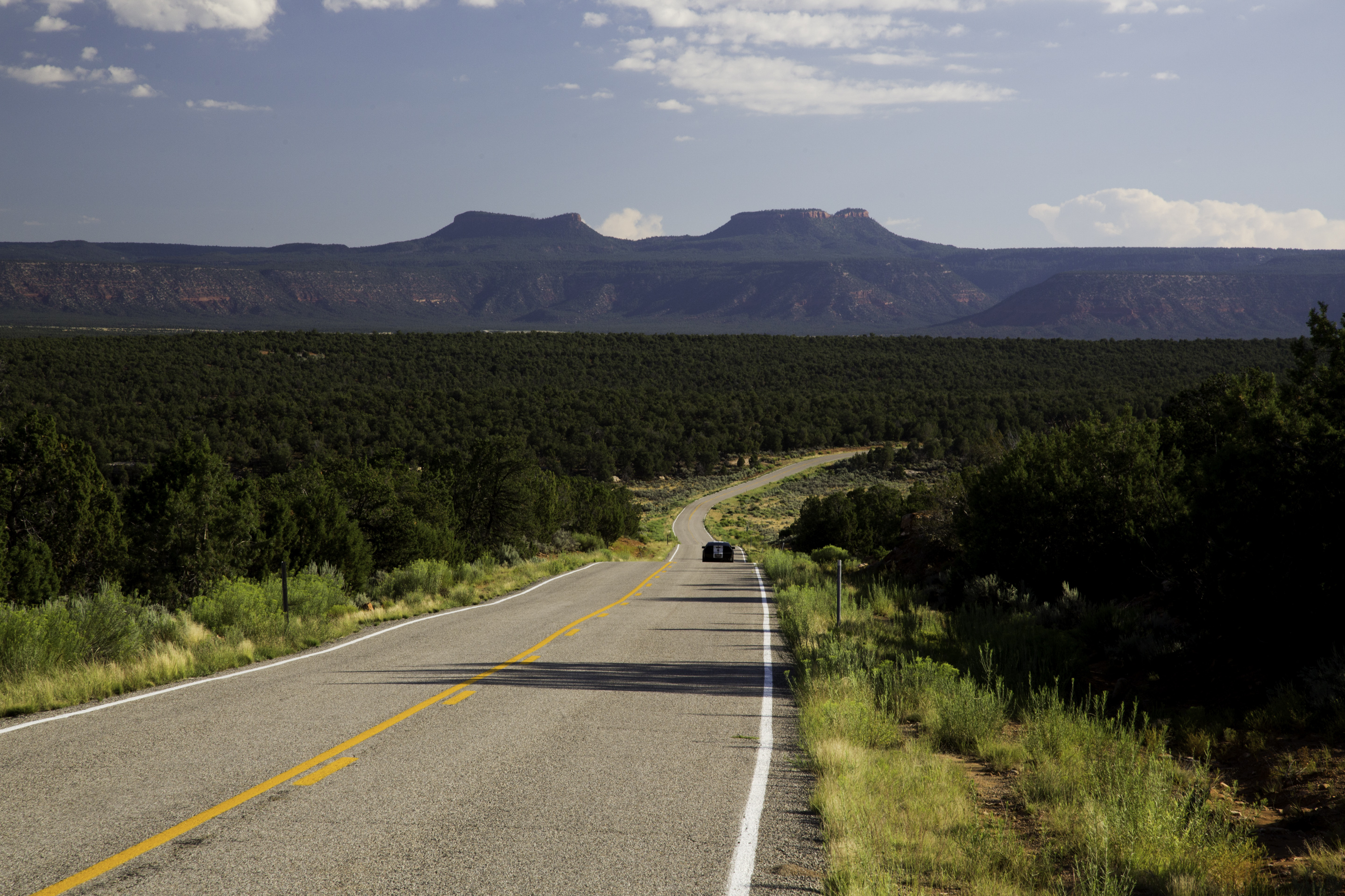
The Bears Ears are a pair of buttes located in San Juan County in southeastern Utah, United States. They are protected as part of and the namesake of the Bears Ears National Monument, managed by the Bureau of Land Management and United States Forest Service. The Bears Ears are bordered on the west by Dark Canyon Wilderness and Beef Basin, on the east by Comb Ridge and on the north by Indian Creek and Canyonlands National Park. Rising above Cedar Mesa to the south, the Bears Ears reach in elevation and are named for their resemblance to the ears of a bear emerging from the horizon. See also * List of mountains in Utah References Further reading * Regina Lopez-WhiteskunkThe fight for Bears Ears, on the road ''High Country News ''High Country News'' is a monthly independent magazine based in Paonia, Colorado, that covers environmental, social, and political issues in the Western United States. Syndicated stories from ''High Country News'' have appeared in ''The New York T . ... [...More Info...] [...Related Items...] OR: [Wikipedia] [Google] [Baidu] |
Utah State Route 261
State Route 261 is a state highway located entirely within south-central San Juan County, Utah. It runs north, from the junction of U.S. Route 163 ( north of Mexican Hat), to the junction with State Route 95, just east of Natural Bridges National Monument. The highway is part of the Utah section of the Trail of the Ancients, a National Scenic Byway. It includes steep switchbacks as it traverses the Moki Dugway. from a website Route description From its southern terminus north of Mexican Hat, SR-261 commences in a westerly direction. After turning north, the route encounters ...[...More Info...] [...Related Items...] OR: [Wikipedia] [Google] [Baidu] |
Dark Canyon Wilderness
Dark Canyon Wilderness is a National Wilderness Preservation System, designated Wilderness Area in the heart of southeast Utah's canyon country, part of the Bears Ears National Monument. The wilderness is named for its high steep walls that narrow in the lower section so that they block the light in the morning and late afternoon. The roughly horseshoe-shaped wilderness is made up of the upper part of Dark Canyon and two major tributaries, Woodenshoe Canyon and Peavine Canyon in the Manti-La Sal National Forest. These canyons all descend from pine-covered Elk Ridge northeast of Natural Bridges National Monument. Dark Canyon continues west within a U.S. Bureau of Land Management primitive area that is recommended for wilderness designation. The last of the main canyon drop steeply through Glen Canyon National Recreation Area into Lake Powell. On December 28, 2016 President Barack Obama proclaimed the 1.35 million acre Bears Ears National Monument, that includes both the Dark Can ... [...More Info...] [...Related Items...] OR: [Wikipedia] [Google] [Baidu] |
Buttes Of Utah
__NOTOC__ In geomorphology, a butte () is an isolated hill with steep, often vertical sides and a small, relatively flat top; buttes are smaller landforms than mesas, plateaus, and tablelands. The word ''butte'' comes from a French word meaning knoll (but of any size); its use is prevalent in the Western United States, including the southwest where ''mesa'' (Spanish for "table") is used for the larger landform. Due to their distinctive shapes, buttes are frequently landmarks in plains and mountainous areas. To differentiate the two landforms, geographers use the rule of thumb that a mesa has a top that is wider than its height, while a butte has a top that is narrower than its height. Formation Buttes form by weathering and erosion when hard caprock overlies a layer of less resistant rock that is eventually worn away. The harder rock on top of the butte resists erosion. The caprock provides protection for the less resistant rock below from wind abrasion which leaves it standing ... [...More Info...] [...Related Items...] OR: [Wikipedia] [Google] [Baidu] |
High Country News
''High Country News'' is a monthly independent magazine based in Paonia, Colorado, that covers environmental, social, and political issues in the Western United States. Syndicated stories from ''High Country News'' have appeared in ''The New York Times'', ''The Atlantic'', ''Rolling Stone'', and other national publications. The non-profit High Country News media organization also produces a website, special reports, and books. Tom Bell, a Wyoming conservationist, rancher, and decorated World War II bombardier, started a newspaper in 1970 that would become the ''High Country News''. He died at the age of 92 in 2016 in Lander, Wyoming, where he had founded ''High Country News''. In 2017, ''High Country News'' became the first non-Native American publication to establish an Indigenous Affairs desk as part of an effort to attract new readers and improve their coverage of Native American issues. Funding ''High Country News'' has more than 35,000 subscribers. In 2017, it received app ... [...More Info...] [...Related Items...] OR: [Wikipedia] [Google] [Baidu] |
List Of Mountains In Utah
Mountains in Utah are numerous and have varying elevations and prominences. Kings Peak, in the Uinta Mountains in Duchesne County, Utah, is the highest point in the state and has the greatest prominence. It has elevation and prominence . It also has topographic isolation of , highest amongst summits of Utah having at least 500 meters of prominence. For lists of the top 50 peaks in Utah by elevation, prominence, and topographic isolation, see List of mountain peaks of Utah. This "List of mountains in Utah" should include all of those (but does not yet) and more. To see locations of all mountains having coordinates in this article (primarily from just three counties in the state, so far) together in one map, click on "Map all coordinates using OSM" at the right side of this page. Partial lists of mountains in just a few of Utah's 29 counties are below. Salt Lake County Mountains in Salt Lake County, Utah include: Utah County Mountains in Utah County, Utah i ... [...More Info...] [...Related Items...] OR: [Wikipedia] [Google] [Baidu] |
Cedar Mesa
Cedar Mesa is a plateau in San Juan County in the southeastern portion of the U.S. state of Utah. It extends from Elk Ridge in the north, Comb Wash to the east, the gorge of the San Juan River to the south, and Grand Gulch to the west, an area of over . The center of the mesa is located at approximately 37°26'N and 109°55'W, at an elevation of . The surrounding terrain has a typical elevation of just Most of Cedar Mesa is included in the newly declared (2016) Bears Ears National Monument. This large difference in elevation has led to the formation of numerous canyons, cliffs, and other erosional features on the edges of the mesa. To the east are several canyons draining into Comb Wash, including Arch, Texas, Mule, Owl, Fish, McCloyd, and Road Canyons. Scattered throughout these canyons are cliff dwellings of the Ancient Puebloans. To the southeast is an eroded area called the Valley of the Gods, and to the southwest is a deep gorge of the San Juan River, called the ... [...More Info...] [...Related Items...] OR: [Wikipedia] [Google] [Baidu] |
Canyonlands National Park
Canyonlands National Park is an American national park located in southeastern Utah near the town of Moab. The park preserves a colorful landscape eroded into numerous canyons, mesas, and buttes by the Colorado River, the Green River, and their respective tributaries. Legislation creating the park was signed into law by President Lyndon Johnson on September 12, 1964. The park is divided into four districts: the Island in the Sky, the Needles, the Maze, and the combined rivers—the Green and Colorado—which carved two large canyons into the Colorado Plateau. While these areas share a primitive desert atmosphere, each retains its own character. Author Edward Abbey, a frequent visitor, described the Canyonlands as "the most weird, wonderful, magical place on earth—there is nothing else like it anywhere." History In the early 1950s, Bates Wilson, then superintendent of Arches National Monument, began exploring the area to the south and west of Moab, Utah. After seeing what is ... [...More Info...] [...Related Items...] OR: [Wikipedia] [Google] [Baidu] |
Comb Ridge
Comb Ridge ( nv, ) is a linear north to south-trending monocline nearly 80 miles long in Southeastern Utah and Northeastern Arizona. Its northern end merges with the Abajo Mountains some eleven miles west of Blanding. It extends essentially due south for to the San Juan River. South of the San Juan the ridge turns to the southwest and is more subdued in expression as it extends for an additional to Laguna Creek east of Kayenta, Arizona.''Geosights, Comb Ridge, San Juan County, Utah,'' May 2012, pp. 9–11 USGS 30x60 quadrangle topographic maps: Blanding, Utah-Colorado; Bluff, Utah-Colorado; Rock Point, Arizona-New Mexico; Kayenta, Arizona It was designated a |
United States Forest Service
The United States Forest Service (USFS) is an agency of the U.S. Department of Agriculture that administers the nation's 154 national forests and 20 national grasslands. The Forest Service manages of land. Major divisions of the agency include the Chief's Office, National Forest System, State and Private Forestry, Business Operations, and Research and Development. The agency manages about 25% of federal lands and is the only major national land management agency not part of the U.S. Department of the Interior, which manages the National Park Service, the U.S. Fish and Wildlife Service, and the Bureau of Land Management. History The concept of national forests was born from Theodore Roosevelt's conservation group, Boone and Crockett Club, due to concerns regarding Yellowstone National Park beginning as early as 1875. In 1876, Congress formed the office of Special Agent in the Department of Agriculture to assess the quality and conditions of forests in the United States. ... [...More Info...] [...Related Items...] OR: [Wikipedia] [Google] [Baidu] |
San Juan County, Utah
San Juan County ( ) is a County (United States), county in the southeastern portion of the U.S. state of Utah. As of the 2010 United States Census, the population was 14,746. Its county seat is Monticello, Utah, Monticello, while its most populous city is Blanding, Utah, Blanding. The Utah State Legislature named the county for the San Juan River (Colorado River), San Juan River, itself named by Spain, Spanish List of explorers, explorers (in honor of John the Apostle, Saint John). San Juan County borders Arizona, Colorado, and New Mexico at the Four Corners. History The Utah Territory authorized creation of San Juan County on February 17, 1880, with territories annexed from Iron County, Utah, Iron, Kane County, Utah, Kane, and Piute County, Piute counties. There has been no change in its boundaries since its creation. Monticello was founded in 1887, and by 1895 it was large enough to be designated the seat of San Juan County. Geography San Juan County lies in the southeaster ... [...More Info...] [...Related Items...] OR: [Wikipedia] [Google] [Baidu] |
Bureau Of Land Management
The Bureau of Land Management (BLM) is an agency within the United States Department of the Interior responsible for administering federal lands. Headquartered in Washington DC, and with oversight over , it governs one eighth of the country's landmass. President Harry S. Truman created the BLM in 1946 by combining two existing agencies: the General Land Office and the Grazing Service. The agency manages the federal government's nearly of subsurface mineral estate located beneath federal, state and private lands severed from their surface rights by the Homestead Act of 1862. Most BLM public lands are located in these 12 western states: Alaska, Arizona, California, Colorado, Idaho, Montana, Nevada, New Mexico, Oregon, Utah, Washington and Wyoming. The mission of the BLM is "to sustain the health, diversity, and productivity of the public lands for the use and enjoyment of present and future generations." Originally BLM holdings were described as "land nobody wanted" because home ... [...More Info...] [...Related Items...] OR: [Wikipedia] [Google] [Baidu] |
Bears Ears National Monument
Bears Ears National Monument is a United States national monument located in San Juan County in southeastern Utah, established by President Barack Obama by presidential proclamation on December 28, 2016. The monument protects of public land surrounding the Bears Ears—a pair of buttes—and the Indian Creek corridor rock climbing area. The Native American names for the buttes have the same meaning in each of the languages represented in the region. The names are listed in the presidential proclamation as "''Hoon’Naqvut'', ''Shash Jáa'' icBegaye, Russell; Nez, Jonathan; et al. (April 16, 2016)"Letter to Obama re Bears Ears initiative" page 1. ''bearsearscoalition.org''. The Bears Ears Inter-Tribal Coalition. Retrieved May 14, 2018. "the Bears Ears Buttes (Shash Jaaʼ)" ''Kwiyaghatʉ Nükavachi/Kwiyagatu Nukavachi'', ''Ansh An Lashokdiwe''"—all four mean "Bears Ears". The area within the monument is largely undeveloped and contains a wide array of historic, cultural and ... [...More Info...] [...Related Items...] OR: [Wikipedia] [Google] [Baidu] |


