|
Baume-les-Messieurs
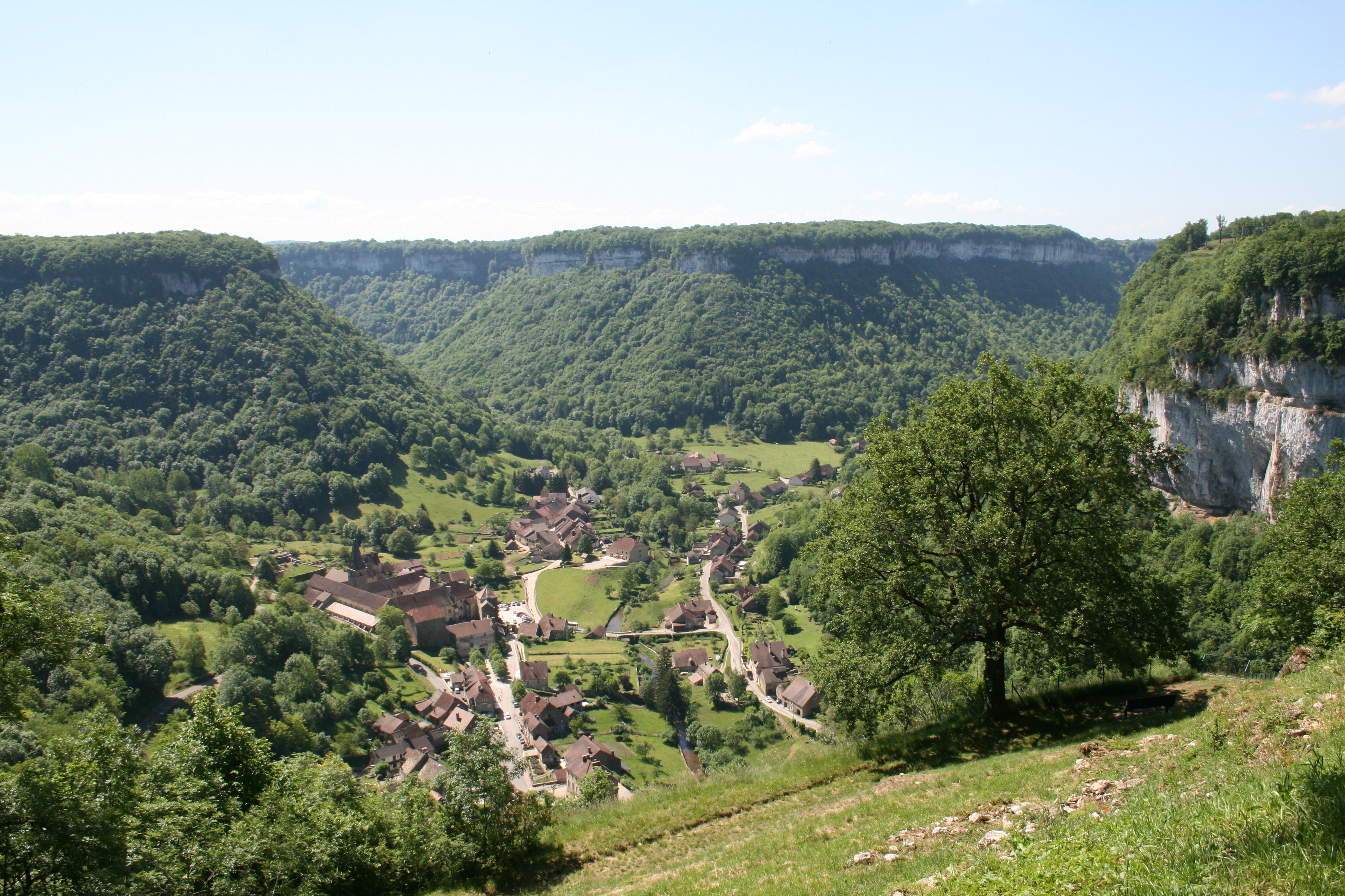
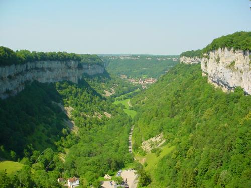
Baume-les-Messieurs () is a commune in the Jura department in the region of Bourgogne-Franche-Comté in eastern France. The village lies within the most extensive of the steephead valleys of the Jura escarpment, the ''Reculée de Baume''. It is therefore almost surrounded by limestone cliffs about 200m high. One of the source rivers of the Seille, the Seille de Baume, has its source within the Reculée and flows through the village. A short tributary of the Seille de Baume, the Dard, merges with the Seille at Baume; at the source of the Dard, also within the Reculée, there is a notable series of caves. The village is dominated by the former Baume Abbey, and in consequence has a significant tourist trade, though this mainly involves day visitors. Conducted tours both of the abbey and of the Dard caves are offered. The GR 59 long-distance footpath passes through the village. Population See also *Baume Abbey *Communes of the Jura department The following is a list o ... [...More Info...] [...Related Items...] OR: [Wikipedia] [Google] [Baidu] |
Baume Abbey
Baume Abbey, in its village of Baume-les-Messieurs, Jura, France, was founded as a Benedictine abbey not far from the still-travelled Roman road linking Besançon and Lyon. It stands near the source of the Dard. Around it the village of Baume-les-Messieurs is congregated. The abbey is known for its sixteenth-century retable. Early history Jean Mabillon followed an early tradition that the abbey had been founded by Saint Columbanus, which would place the foundation in the late sixth century. Bernard Prost says that in 732 Saracen raiders destroyed the obscure community of monks, along with neighboring Château-Châlon and the village of Lons-le-Saunier. It was refounded during the reign of Louis the Pious in the early ninth century by Saint Eutice, probably a disciple of Benedict of Aniane, who was revitalizing and reordering the Benedictine communities of the Gauls. In 817, when Emperor Louis at Aachen divided the monasteries in his lands into three categories, ''monasterium B ... [...More Info...] [...Related Items...] OR: [Wikipedia] [Google] [Baidu] |
Dard (river)
The Dard is a short (2.1 km) tributary of the Seille de Beaume in the department of Jura in France. The Dard rises in the steephead valley known as the ''Reculée de Baume'', and flows through the valley to the village of Baume-les-Messieurs, where it joins the Seille de Beaume. At its source there is a notable series of show cave A show cave—also called tourist cave, public cave, and, in the United States, commercial cave—is a cave which has been made accessible to the public for guided visits. Definition A show cave is a cave that has been made accessible to ...s, which can be visited. References Rivers of France Rivers of Bourgogne-Franche-Comté Rivers of Jura (department) {{France-river-stub ... [...More Info...] [...Related Items...] OR: [Wikipedia] [Google] [Baidu] |
Jura (department)
Jura ( , ) is a department in the Bourgogne-Franche-Comté region in Eastern France. Named after the Jura Mountains, its prefecture is Lons-le-Saunier. Its subprefectures are Dole and Saint-Claude. In 2019, Jura had a population of 259,199.Populations légales 2019: 39 Jura INSEE Its INSEE code is 39. It has a short portion of the border of Switzerland. History Historically, Jura belonged to the |
Communes Of The Jura Department
The following is a list of the 494 communes of the Jura department of France. The communes cooperate in the following intercommunalities (as of 2020):BANATIC Périmètre des EPCI à fiscalité propre. Accessed 3 July 2020. * * |
GR 59
The GR 59 Grande Randonnée long-distance footpath in France connects two mountain ranges across relatively low-lying terrain. In the north, it begins at Ballon d'Alsace in the Vosges at a height of over 1000m. It loses height rapidly, and runs south-south-west through the département of the Haute-Saône to Besançon on the river Doubs (river), Doubs, in the département of the same name. It then follows a circuitous route, partly along the river Loue (a tributary of the Doubs) to Lons-le-Saunier in the département of Jura (department), Jura. At Saint-Amour, Jura, St-Amour just south of Lons, the GR 9 splits from the GR 59 and takes a more easterly route, near the Switzerland, Swiss border, while the GR59 continues into the regions of Bugey and Revermont in the département of Ain, finally rejoining the GR 9 near Yenne on the banks of the Rhône; the GR 9 then continues to the Mediterranean at St-Tropez. Towns and villages that the path passes through, with approximate height ... [...More Info...] [...Related Items...] OR: [Wikipedia] [Google] [Baidu] |
Steephead Valley
A steephead valley, steephead or blind valley is a deep, narrow, flat bottomed valley with an abrupt ending. Such closed valleys may arise in limestone or karst landscapes, where a layer of permeable rock lies above an impermeable substract such as marl. Water flowing through a steephead valley leaves via one or more ponors or sinkholes. Blind valleys are typically dry at their lower ends. If the ponor cannot contain the high runoff during a flood event an intermittent flow may continue through the valley beyond the sink. Such a landform is called a semi-blind or half-blind valley. Development They are created by a stream flowing within the permeable rock and eroding it from within, until the rock above collapses opening up a steep narrow valley which is then further eroded by the stream running across the impermeable valley floor. At the head of the valley the stream emerges from the rock as a spring. Notable examples can be found in the Jura region of France, for example ... [...More Info...] [...Related Items...] OR: [Wikipedia] [Google] [Baidu] |
Espace Communautaire Lons Agglomération
Espace Communautaire Lons Agglomération is the ''communauté d'agglomération'', an intercommunal structure, centred on the town of Lons-le-Saunier. It is located in the Jura department, in the Bourgogne-Franche-Comté region, eastern France. Created in 2017, its seat is in Lons-le-Saunier.CA ECLA (Espace Communautaire Lons Agglomération) (N° SIREN : 200071116) BANATIC. Retrieved 21 November 2022. Its area is 196.7 km2. Its population was 34,189 in 2019, of which 17,189 in Lons-le-Saunier proper.Comparateur de territoire ... [...More Info...] [...Related Items...] OR: [Wikipedia] [Google] [Baidu] |
Seille (Saône)
The Seille () is a river originating in the Jura mountains in France. It is a left tributary of the Saône, joining it in the commune of La Truchère, in Saône-et-Loire. It is long. The river's headwaters are in the ''reculée'' (blind valley) of Ladoye-sur-Seille, approximately 8 km south of Poligny. It is joined by the ''Seille de Beaume'', that springs in the blind valley of Baume-les-Messieurs, in Nevy-sur-Seille. From there it crosses the vineyards of the Jura department, irrigating the communes of Nevy-sur-Seille, Voiteur, and Arlay, before reaching the agricultural plain of Bletterans. It then passes Louhans and the Bresse area in the department of Saône-et-Loire, finally flowing into the Saône at La Truchère, a few kilometers south of Tournus. Near its mouth, the Seille forms a 3047 hectare network of ponds, dunes, and bogs, providing a habitat for a large number of migratory birds, including endangered species and rare plant species. The upper part of t ... [...More Info...] [...Related Items...] OR: [Wikipedia] [Google] [Baidu] |
Communes Of France
The () is a level of administrative division in the French Republic. French are analogous to civil townships and incorporated municipalities in the United States and Canada, ' in Germany, ' in Italy, or ' in Spain. The United Kingdom's equivalent are civil parishes, although some areas, particularly urban areas, are unparished. are based on historical geographic communities or villages and are vested with significant powers to manage the populations and land of the geographic area covered. The are the fourth-level administrative divisions of France. vary widely in size and area, from large sprawling cities with millions of inhabitants like Paris, to small hamlets with only a handful of inhabitants. typically are based on pre-existing villages and facilitate local governance. All have names, but not all named geographic areas or groups of people residing together are ( or ), the difference residing in the lack of administrative powers. Except for the municipal arrondi ... [...More Info...] [...Related Items...] OR: [Wikipedia] [Google] [Baidu] |
Long-distance Footpath
A long-distance trail (or long-distance footpath, track, way, greenway) is a longer recreational trail mainly through rural areas used for hiking, backpacking, cycling, horse riding or cross-country skiing. They exist on all continents except Antarctica. Many trails are marked on maps. Typically, a long-distance route will be at least long, but many run for several hundred miles, or longer. Many routes are waymarked and may cross public or private land and/or follow existing rights of way. Generally, the surface is not specially prepared, and the ground can be rough and uneven in areas, except in places such as converted rail tracks or popular walking routes where stone-pitching and slabs have been laid to prevent erosion. In some places, official trails will have the surface specially prepared to make the going easier. Historically Historically, and still nowadays in countries where most people move on foot or with pack animals, long-distance trails linked far away ... [...More Info...] [...Related Items...] OR: [Wikipedia] [Google] [Baidu] |
Tourism
Tourism is travel for pleasure or business; also the theory and practice of touring (other), touring, the business of attracting, accommodating, and entertaining tourists, and the business of operating tour (other), tours. The World Tourism Organization defines tourism more generally, in terms which go "beyond the common perception of tourism as being limited to holiday activity only", as people "travelling to and staying in places outside their usual environment for not more than one consecutive year for leisure and not less than 24 hours, business and other purposes". Tourism can be Domestic tourism, domestic (within the traveller's own country) or International tourism, international, and international tourism has both incoming and outgoing implications on a country's balance of payments. Tourism numbers declined as a result of a strong economic slowdown (the late-2000s recession) between the second half of 2008 and the end of 2009, and in consequence of t ... [...More Info...] [...Related Items...] OR: [Wikipedia] [Google] [Baidu] |
Cave
A cave or cavern is a natural void in the ground, specifically a space large enough for a human to enter. Caves often form by the weathering of rock and often extend deep underground. The word ''cave'' can refer to smaller openings such as sea caves, rock shelters, and grottos, that extend a relatively short distance into the rock and they are called ''exogene'' caves. Caves which extend further underground than the opening is wide are called ''endogene'' caves. Speleology is the science of exploration and study of all aspects of caves and the cave environment. Visiting or exploring caves for recreation may be called ''caving'', ''potholing'', or ''spelunking''. Formation types The formation and development of caves is known as ''speleogenesis''; it can occur over the course of millions of years. Caves can range widely in size, and are formed by various geological processes. These may involve a combination of chemical processes, erosion by water, tectonic forces, microorgani ... [...More Info...] [...Related Items...] OR: [Wikipedia] [Google] [Baidu] |


