|
Battersea (UK Parliament Constituency)
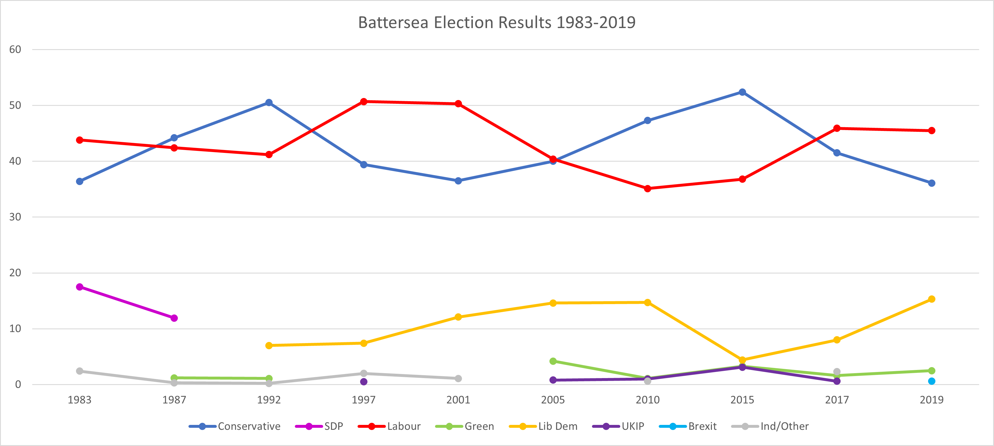
Battersea is a constituency in the London Borough of Wandsworth. It has been represented since 2017 by Marsha de Cordova of the Labour Party. The seat has had two periods of existence (1885–1918 and 1983 to date). In the first Parliament after the seat's re-creation it was Labour-represented, bucking the national result, thereafter from 1987 until 2017 the affiliation of the winning candidate was that of the winning party nationally – a 30-year bellwether. In the 2016 referendum to leave the European Union, the constituency voted remain by an estimated 77%, the highest by a constituency with a Conservative MP at the time. Boundaries 1885–1918: Wards 2 and 3 of Battersea Parish, and that part of No. 4 Ward bounded on the south by Battersea Rise, and on the east by St John's Road. 1983–2010: The London Borough of Wandsworth wards of Balham, Fairfield, Latchmere, Northcote, Queenstown, St John, St Mary's Park and Shaftesbury. St John Ward was abolished for the 2002 W ... [...More Info...] [...Related Items...] OR: [Wikipedia] [Google] [Baidu] |
Greater London
Greater may refer to: *Greatness, the state of being great *Greater than, in inequality (mathematics), inequality *Greater (film), ''Greater'' (film), a 2016 American film *Greater (flamingo), the oldest flamingo on record *Greater (song), "Greater" (song), by MercyMe, 2014 *Greater Bank, an Australian bank *Greater Media, an American media company See also * * {{Disambiguation ... [...More Info...] [...Related Items...] OR: [Wikipedia] [Google] [Baidu] |
Tooting (UK Parliament Constituency)
Tooting is a constituency created in 1974 in Greater London. It is represented in the House of Commons of the UK Parliament since 2016 by Dr. Rosena Allin-Khan, a member of the Labour Party. Boundaries 1974–1983: The London Borough of Wandsworth wards of Bedford, Furzedown, Graveney, Springfield, and Tooting. 1983–2010: As above plus Earlsfield, and Nightingale 2010–present: As above minus Springfield, plus Wandsworth Common. Tooting is the south-eastern third of the London Borough of Wandsworth. In addition to Tooting, it includes the districts of Earlsfield, Furzedown and Streatham Park and part of Balham. The constituency includes part of Wandsworth Common, a rectangular open space that lends its name to one of the seven wards. Tooting since 2010 is bordered to the west by Putney and Wimbledon; to the other three compass points by Mitcham and Morden, Streatham and Battersea. History The constituency was created for the February 1974 election from areas which, ... [...More Info...] [...Related Items...] OR: [Wikipedia] [Google] [Baidu] |
Clapham Common
Clapham Common is a large triangular urban park in Clapham, south London, England. Originally common land for the parishes of Battersea and Clapham, it was converted to parkland under the terms of the Metropolitan Commons Act 1878. It is of green space, with three ponds and a Victorian bandstand. It is overlooked by large Georgian and Victorian mansions and nearby Clapham Old Town. Holy Trinity Clapham, an 18th-century Georgian church overlooking the park, is important in the history of the evangelical Clapham Sect. Half of the park is within the London Borough of Wandsworth, and the other half is within the London Borough of Lambeth. History Originally common land for the parishes of Battersea and Clapham, William Hewer was among the early Londoners to build adjacent to it. Samuel Pepys, the diarist, died at Hewer's house in 1703. The land had been used for cricket in 1700 and was drained in the 1760s, and from the 1790s onwards fine houses were built around the common ... [...More Info...] [...Related Items...] OR: [Wikipedia] [Google] [Baidu] |
Wandsworth Common
Wandsworth Common is a public common in Wandsworth, in the London Borough of Wandsworth, south London. It is and is maintained and regulated by Wandsworth Council. It is also a Ward of the London Borough of Wandsworth. The population of the ward at the 2011 Census was 15,247. Amenities There are a number of ponds and a lake, which can be used for fishing (with a permit). The lake is partially fenced off for the benefit of bird life, while other areas feature wooden pedestrian board walks, or open water's edge access. A small brick bridge crosses over the lake's waters at one point, connecting two pedestrian pathways. A railway line running between Clapham Junction and Wandsworth Common railway stations broadly divides the common into two strips, west and east. A footbridge crosses the railway approximately halfway along the length of the open part of the common. To the east of the railway line there is a large area which is mainly used for competitive sports (mostly football, to ... [...More Info...] [...Related Items...] OR: [Wikipedia] [Google] [Baidu] |
Fairfield (Wandsworth Ward)
Fairfield is one of the most central wards in the London Borough of Wandsworth, London. Fairfield contains mostly Wandsworth Town and a large neighbourhood in Battersea. Fairfield contains Wandsworth High Street, Old York Road and the council buildings themselves. The ward forms a cross shape, running from Mexfield Road on the edge of Putney in the west, to Plough Road near Clapham Junction in the east, and from the River Thames to the west of Wandsworth Bridge in the north, to Allfarthing Lane to the east of Garratt Lane in the south. Demographics The ward has a young demographic, with 62% of the population between the ages of 20 and 44. 52% of the population is female. Councillors * William Sweet (Conservative Party) * Piers McCausland (Conservative Party) * Rory O'Broin (Conservative Party The Conservative Party is a name used by many political parties around the world. These political parties are generally right-wing though their exact ideologies can range from center- ... [...More Info...] [...Related Items...] OR: [Wikipedia] [Google] [Baidu] |
Wandsworth Town Hall
Wandsworth Town Hall is a municipal building on the corner of Wandsworth High Street and Fairfield Street in Wandsworth, London. The building, which is the headquarters of Wandsworth London Borough Council, is a Grade II listed building. History In the mid-19th century Wandsworth Vestry met in the vestry room of All Saints Church. After civic leaders found this arrangement was inadequate, they decided to procure a purpose-built vestry hall: the site selected was a row of properties in the High Street. The new building was designed by George Patrick in a mixture of the Italianate and French Renaissance styles, built by Mr Parsons of Wandsworth and completed in 1882. It went on to become the headquarters of the Metropolitan Borough of Wandsworth as "Wandsworth Town Hall" in 1900. A modest two-storey structure faced in red-brick over channeled stone, designed by Ernest Elford in the Classical style, and now known as the "civic suite", was erected in the High Street to the east o ... [...More Info...] [...Related Items...] OR: [Wikipedia] [Google] [Baidu] |
South West Main Line
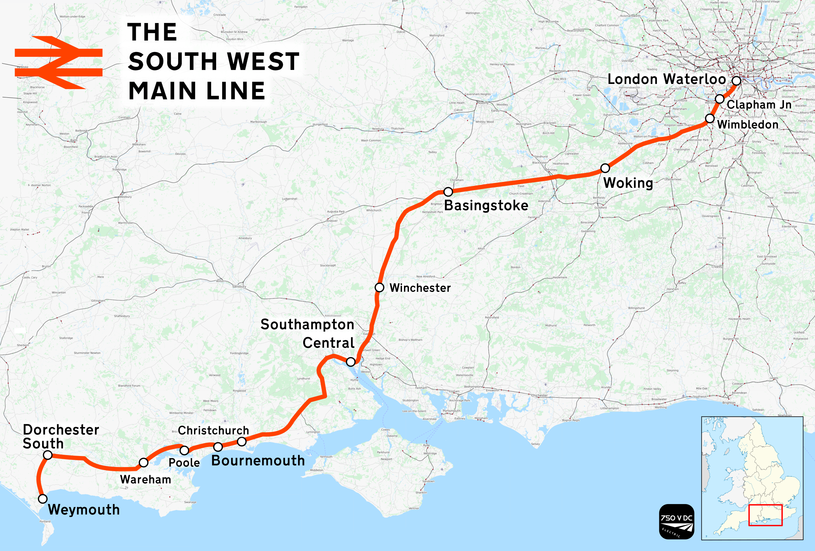
The South West Main Line (SWML) is a 143-mile (230 km) major railway line between Waterloo station in central London and Weymouth on the south coast of England. A predominantly passenger line, it serves many commuter areas including south western suburbs of London and the conurbations based on Southampton and Bournemouth. It runs through the counties of Surrey, Hampshire and Dorset. It forms the core of the network built by the London and South Western Railway, today mostly operated by South Western Railway. Network Rail refers to it as the South West Main Line. Operating speeds on much of the line are relatively high, with large stretches cleared for up to running. The London end of the line has as many as eight tracks plus the two Windsor Lines built separately, but this narrows to four by and continues this way until Worting Junction west of , from which point most of the line is double track. A couple of miles from the Waterloo terminus, the line runs briefly alongside ... [...More Info...] [...Related Items...] OR: [Wikipedia] [Google] [Baidu] |
Queenstown Road Battersea Railway Station
Queenstown Road is a railway station in inner south-west London, south-west of , between and . It is a short walk from Battersea Park station and Battersea Park to the west. It has three platforms, two of which are in use by all stopping services related to the Waterloo to Reading Line: its branch services to Weybridge (via Hounslow) and two separate sets of bidirectional Waterloo-to-Waterloo services via Hounslow using the Hounslow Loop and via Kingston using the Kingston Loop. In addition, 50% of maximum peak hour trains serving the Shepperton branch line call at the station. History The station was opened on 1 November 1877, by the London and South Western Railway, as ''Queen's Road (Battersea)''. The entrance still bears the name Queen's Road, not to be confused with Queens Road Peckham, Walthamstow Queen's Road or Queensway Underground station, which was also originally called Queens Road. Queen's Road was also the name of the road in which the station is locat ... [...More Info...] [...Related Items...] OR: [Wikipedia] [Google] [Baidu] |
Nine Elms
Nine Elms is an area of south-west London, England, within the London Borough of Wandsworth. It lies on the River Thames, with Battersea to the west, South Lambeth to the south and Vauxhall to the east. The area was formerly mainly industrial but is now becoming more residential and commercial in character. It is dominated by Battersea Power Station, various railway lines and New Covent Garden Market. The Battersea Dogs & Cats Home is also in the area. Nine Elms has residential developments along the riverside, including Chelsea Bridge Wharf and Embassy Gardens, and also three large council estates: Carey Gardens, the Patmore Estate and the Savona. History Nine Elms Lane was named around the year 1645, from a row of elm trees bordering the road, though a path probably existed between York House and Vauxhall from the 1200s. In 1838, at the time of construction of the London and Southampton Railway, the area was described as "a low swampy district occasionally overflowed by th ... [...More Info...] [...Related Items...] OR: [Wikipedia] [Google] [Baidu] |
London Heliport
London Heliport , previously called Battersea Heliport and currently known officially as the Edmiston London Heliport for sponsorship reasons, is London's only licensed heliport. The facility, which was built by W. & C. French and opened on 23 April 1959, is located in Battersea on the south bank of the River Thames, southwest of Westminster Bridge and between Wandsworth Bridge and Battersea Railway Bridge. Prior to the official opening, the first aircraft to land at the heliport on 8 April 1959, was a Westland Widgeon Series 2, owned by Westland Aircraft. The heliport, once owned by Westland and then Harrods, is a very small site, making use of a jetty to provide a helipad for take-off and landing, and onshore parking for three to four aircraft, depending upon their size. The heliport provides landing, parking and refuelling services between 08:00 and 21:00 (flights are permitted between 07:00 and 23:00), albeit parking is normally restricted to smaller helicopter categories ... [...More Info...] [...Related Items...] OR: [Wikipedia] [Google] [Baidu] |
Battersea Park
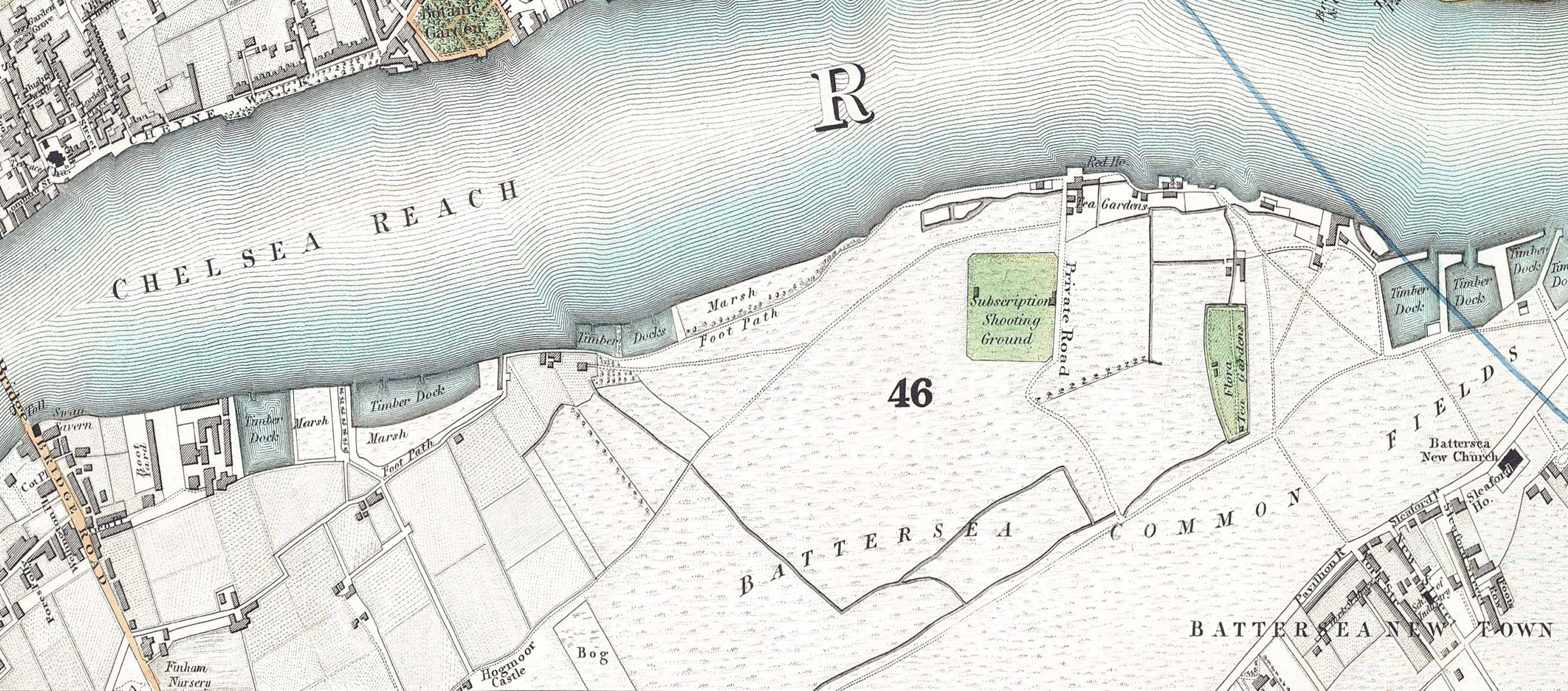
Battersea Park is a 200-acre (83-hectare) green space at Battersea in the London Borough of Wandsworth in London. It is situated on the south bank of the River Thames opposite Chelsea and was opened in 1858. The park occupies marshland reclaimed from the Thames and land formerly used for market gardens. The park is Grade II* listed on the Register of Historic Parks and Gardens. History Prior to 1846, the area now covered by the park was known as Battersea fields, a popular spot for duelling. On 21 March 1829, the Duke of Wellington and the Earl of Winchilsea met on Battersea fields to settle a matter of honour. When it came time to fire, the duke aimed his duelling pistol wide and Winchilsea fired his into the air. Winchilsea later wrote the duke a groveling apology. Separated from the river by a narrow raised causeway, the fields consisted of low, fertile marshes intersected by streams and ditches with the chief crops being carrots, melons, lavender (all the way up to Lave ... [...More Info...] [...Related Items...] OR: [Wikipedia] [Google] [Baidu] |
River Thames
The River Thames ( ), known alternatively in parts as the The Isis, River Isis, is a river that flows through southern England including London. At , it is the longest river entirely in England and the Longest rivers of the United Kingdom, second-longest in the United Kingdom, after the River Severn. The river rises at Thames Head in Gloucestershire, and flows into the North Sea near Tilbury, Essex and Gravesend, Kent, via the Thames Estuary. From the west it flows through Oxford (where it is sometimes called the Isis), Reading, Berkshire, Reading, Henley-on-Thames and Windsor, Berkshire, Windsor. The Thames also drains the whole of Greater London. In August 2022, the source of the river moved five miles to beyond Somerford Keynes due to the heatwave in July 2022. The lower reaches of the river are called the Tideway, derived from its long tidal reach up to Teddington Lock. Its tidal section includes most of its London stretch and has a rise and fall of . From Oxford to th ... [...More Info...] [...Related Items...] OR: [Wikipedia] [Google] [Baidu] |


