|
Bannetze
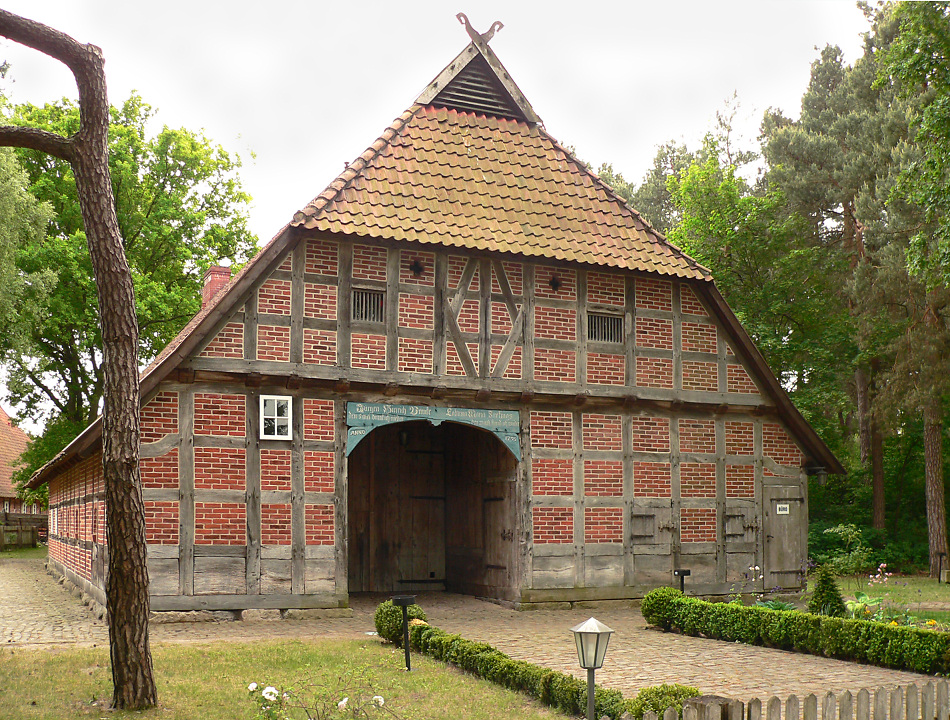
Bannetze is a village and ''Ortschaft'' (municipal division) on the River Aller in the municipality of Winsen (Aller) in the district of Celle in the north German state of Lower Saxony. The '' L180'' state road passes through the village.''SV Grün Weiß Bannetze 1959 e.V.'' at www.bannetze-sport.de. Retrieved on 20 Jun 2010. The village has under 400 inhabitants. Politics The village of Bannetze has a joint council with neighbouring Thören. The council chair is Heinrich Leymers (CDU).Culture and places of interest * The Bannetze Weir on the Aller (''Allerwehr Bannetze'') is the second barrage on the Aller below Celle and was built between 1909 and 1912. The old |
Aller (Germany)
The Aller is a river in the states of Saxony-Anhalt and Lower Saxony in Germany. It is a right-hand, and hence eastern, tributary of the Weser and is also its largest tributary. Its last form the Lower Aller federal waterway (''Bundeswasserstraße''). The Aller was extensively straightened, widened and, in places, dyked, during the 1960s to provide flood control of the river. In a section near Gifhorn, the river meanders in its natural river bed. History Meaning of the name The river's name, which was recorded in 781 as ''Alera'', in 803 as ''Elera'', in 1096 as ''Alara'', has two possible derivations: # A shortened form of ''*Eleraha'', where ''*Eler'' in Old German ''*olisa'' or Old Slavic ''olsa'' (Polish: ''olsza'') would mean ''Erle'' ("alder") and ''aha'' (pronounced in German: ''Acha'') is an old word frequently used in river names to mean "water" (c.f. the Latin ''aqua''). The name of the tree passed into Low German as ''Eller'', which is very close to the word ... [...More Info...] [...Related Items...] OR: [Wikipedia] [Google] [Baidu] |
Winsen (Aller)
Winsen an der Aller () or Winsen (Aller) is a town in the district of Celle in the German state of Lower Saxony. Geography Winsen has around 12,900 inhabitants and lies on the southern perimeter of the Lüneburg Heath, on the banks of the Aller, somewhat to the west of its tributary, the Örtze and about 15 km northwest of Celle. As well as the town itself, the borough of Winsen also includes the villages of Bannetze, Meißendorf, Stedden, Südwinsen, Thören, Walle and Wolthausen. History The name of the town is derived from ''Wynhausen'' (''Wyn'' = ''Weideland'' or meadow). Winsen's church is dedicated to John the Baptist. Because all villages with churches named after this patron saint appeared around 800 it is suspected that this was also when Winsen was founded. Today Winsen is a favourite local recreation and holiday area and, since 1975, has been recognised officially as a climatic health resort (''Luftkurort''). Politics Coat of Arms The coat of arms of the town ... [...More Info...] [...Related Items...] OR: [Wikipedia] [Google] [Baidu] |
Landkreis Celle
Celle () is a district (''Landkreis'') in Lower Saxony, Germany. It is bounded by (from the north and clockwise) the districts of Uelzen, Gifhorn, Hanover and Heidekreis. Geography The district is located in the southernmost parts of the Lüneburg Heath (''Lüneburger Heide''). The Aller River enters the district in the east, runs through the town of Celle and leaves the district in the northwest. It is joined by many tributaries coming from the south. Lüneburg Regional Association To look after cultural matters the Lüneburg Regional Association (''Lüneburgischer Landschaftsverband'') was founded as a registered association (''eingetragener Verein''). Coat of arms The lion and the heart were part of the arms of the Lüneburg, a subdivision of the Duchy of Brunswick-Lüneburg. The Principality was occasionally (but incorrectly) also known as Brunswick-Celle, since Celle was its capital for some time. The only difference is the number of hearts (the original coat o ... [...More Info...] [...Related Items...] OR: [Wikipedia] [Google] [Baidu] |
Lower Saxony
Lower Saxony (german: Niedersachsen ; nds, Neddersassen; stq, Läichsaksen) is a German state (') in northwestern Germany. It is the second-largest state by land area, with , and fourth-largest in population (8 million in 2021) among the 16 ' federated as the Federal Republic of Germany. In rural areas, Northern Low Saxon and Saterland Frisian are still spoken, albeit in declining numbers. Lower Saxony borders on (from north and clockwise) the North Sea, the states of Schleswig-Holstein, Hamburg, , Brandenburg, Saxony-Anhalt, Thuringia, Hesse and North Rhine-Westphalia, and the Netherlands. Furthermore, the state of Bremen forms two enclaves within Lower Saxony, one being the city of Bremen, the other its seaport, Bremerhaven (which is a semi-enclave, as it has a coastline). Lower Saxony thus borders more neighbours than any other single '. The state's largest cities are state capital Hanover, Braunschweig (Brunswick), Lüneburg, Osnabrück, Oldenburg, Hildesheim, Salzgitt ... [...More Info...] [...Related Items...] OR: [Wikipedia] [Google] [Baidu] |
Landstraße
Landstraße (; Central Bavarian: ''Laundstrossn'') is the 3rd municipal district of Vienna, Austria (german: 3. Bezirk). It is near the center of Vienna and was established in the 19th century. Landstraße is a heavily populated urban area with many workers and residential homes. Wien.gv.at webpage (see below: References). It has 89,834 inhabitants in an area of 7.42 km2 (2.9 sq miles). It has existed since about 1200 AD. In 1192, the English king Richard the Lionheart was captured in the Erdberg neighbourhood, after the unsuccessful Third Crusade. The name ''Landstraße'' means "country road". To tourists, it is mostly known for the 18th-century castle and gardens of Belvedere, the residence of Eugene of Savoy, which today houses the Austrian Gallery. Another residence was built by the Russian envoy to Vienna, Count Razumovsky. A more recent point of interest is the Hundertwasserhaus block of flats (apartment block) designed in a dream-like style by the architect and paint ... [...More Info...] [...Related Items...] OR: [Wikipedia] [Google] [Baidu] |
Weir
A weir or low head dam is a barrier across the width of a river that alters the flow characteristics of water and usually results in a change in the height of the river level. Weirs are also used to control the flow of water for outlets of lakes, ponds, and reservoirs. There are many weir designs, but commonly water flows freely over the top of the weir crest before cascading down to a lower level. Etymology There is no single definition as to what constitutes a weir and one English dictionary simply defines a weir as a small dam, likely originating from Middle English ''were'', Old English ''wer'', derivative of root of ''werian,'' meaning "to defend, dam". Function Commonly, weirs are used to prevent flooding, measure water discharge, and help render rivers more navigable by boat. In some locations, the terms dam and weir are synonymous, but normally there is a clear distinction made between the structures. Usually, a dam is designed specifically to impound water behind ... [...More Info...] [...Related Items...] OR: [Wikipedia] [Google] [Baidu] |
Lock (water Transport)
A lock is a device used for raising and lowering boats, ships and other watercraft between stretches of water of different levels on river and canal waterways. The distinguishing feature of a lock is a fixed chamber in which the water level can be varied; whereas in a caisson lock, a boat lift, or on a canal inclined plane, it is the chamber itself (usually then called a caisson) that rises and falls. Locks are used to make a river more easily navigable, or to allow a canal to cross land that is not level. Later canals used more and larger locks to allow a more direct route to be taken. Pound lock A ''pound lock'' is most commonly used on canals and rivers today. A pound lock has a chamber with gates at both ends that control the level of water in the pound. In contrast, an earlier design with a single gate was known as a flash lock. Pound locks were first used in China during the Song Dynasty (960–1279 AD), having been pioneered by the Song politician and naval en ... [...More Info...] [...Related Items...] OR: [Wikipedia] [Google] [Baidu] |
Fishway
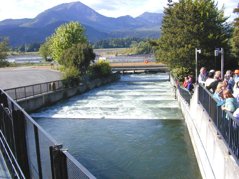
A fish ladder, also known as a fishway, fish pass, fish steps, or fish cannon is a structure on or around artificial and natural barriers (such as dams, locks and waterfalls) to facilitate diadromous fishes' natural migration as well as movements of potamodromous species. Most fishways enable fish to pass around the barriers by swimming and leaping up a series of relatively low steps (hence the term ''ladder'') into the waters on the other side. The velocity of water falling over the steps has to be great enough to attract the fish to the ladder, but it cannot be so great that it washes fish back downstream or exhausts them to the point of inability to continue their journey upriver. History Written reports of rough fishways date to 17th-century France, where bundles of branches were used to make steps in steep channels to bypass obstructions. A pool and weir salmon ladder was built around 1830 by James Smith, a Scottish engineer on the River Teith, near Deanston, Perthshire ... [...More Info...] [...Related Items...] OR: [Wikipedia] [Google] [Baidu] |
Villages In Lower Saxony
A village is a clustered human settlement or community, larger than a hamlet but smaller than a town (although the word is often used to describe both hamlets and smaller towns), with a population typically ranging from a few hundred to a few thousand. Though villages are often located in rural areas, the term urban village is also applied to certain urban neighborhoods. Villages are normally permanent, with fixed dwellings; however, transient villages can occur. Further, the dwellings of a village are fairly close to one another, not scattered broadly over the landscape, as a dispersed settlement. In the past, villages were a usual form of community for societies that practice subsistence agriculture, and also for some non-agricultural societies. In Great Britain, a hamlet earned the right to be called a village when it built a church. [...More Info...] [...Related Items...] OR: [Wikipedia] [Google] [Baidu] |


