|
Ban Kenpha
Ban Kenpha is a village in Houaphanh Province, northeastern Laos Laos (, ''Lāo'' )), officially the Lao People's Democratic Republic ( Lao: ສາທາລະນະລັດ ປະຊາທິປະໄຕ ປະຊາຊົນລາວ, French: République démocratique populaire lao), is a socialist .... It is to the northeast of Vieng Kham, not far from Muang Xon. References Populated places in Houaphanh Province {{Laos-geo-stub ... [...More Info...] [...Related Items...] OR: [Wikipedia] [Google] [Baidu] |
Provinces Of Laos
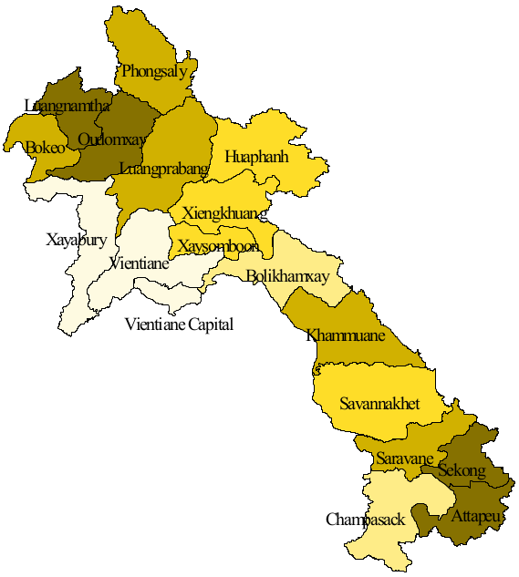
Laos, officially the ''Lao People's Democratic Republic'', is divided into 17 provinces ( Lao ແຂວງ, , , or ) and one prefecture, the Vientiane capital city municipality (ນະຄອນຫຼວງ, nakhon louang, or ''Na Kone Luang Vientiane''). The special administrative zone (ເຂດພິເສດ, ''khet phiset''), Xaisomboun, created in 1994, was dissolved on 13 January 2006. In 2013, parts of the former special administrative zone was reestablished as Xaisomboun province. Provinces and prefectures of Laos Population The population of each province in 2015 is given in the census data. History In 1989 Vientiane prefecture was split from Vientiane province and the capital of Vientiane province moved from Vientiane to Muang Phôn-Hông. In 1994 Xaisômboun khetphiset (special region) was formed from parts of the Bolikhamxai, Vientiane, and Xiangkhoang provinces. In 2006 Xaisomboun special region was dissolved and the Longsan, Xaysomboun, Phun, and Hom dist ... [...More Info...] [...Related Items...] OR: [Wikipedia] [Google] [Baidu] |
Houaphanh Province
Houaphanh province ( Laotian: ຫົວພັນ ; Romanization of Lao: ''Houaphan'') is a province in eastern Laos. Its capital is Xam Neua. Houaphanh province covers an area of . The province is bordered by Vietnam to the north, east, and southeast, Xiangkhouang province to the south and southwest, and Luang Prabang province to the west. The terrain is rugged, with dense, forested mountains forming much of the province, particularly on the western side. The main road running through the province is Route 6. The principal rivers are the Nam Ma, which flows from and into Vietnam, passing the village of Ban Muang-Et, and the Nam Sam, on which the towns of Sam Neua and Sam Tai lie. The province is the home to the Viengxay caves, an extensive network of caves used by the Pathet Lao, and the Hintang Archaeological Park, one of the most important pre-historic sites in northern Laos, dotted with standing megaliths. Houaphanh is one of the poorest areas of Laos, but has dramat ... [...More Info...] [...Related Items...] OR: [Wikipedia] [Google] [Baidu] |
Districts Of Laos
Laos is divided into 17 provinces ( Lao: ແຂວງ, '' khoueng'') and 1 prefecture (''kampheng nakhon''), or capital city municipality (ນະຄອນຫລວງ, '' nakhon luang''). Furthermore, 1 so-called special administrative zone (ເຂດພິເສດ, '' khet phiset'') existed between 1994 and 2006, when it was re-merged into its surrounding provinces (i.e. Vientiane and Xiangkhoang). The Xaisomboun special administrative zone was later recreated as the 17th province. Each province is subdivided into districts ( Lao: ເມືອງ, ''mueang'') and then subdivided into villages ( Lao: ບ້ານ, ''baan''). Districts of Laos :Note — Each district has a code in parentheses displaying the first two digits as the province and the last two as the district representing that province. References External links * * Laos Ministry of Education district maps [...More Info...] [...Related Items...] OR: [Wikipedia] [Google] [Baidu] |
Laos
Laos (, ''Lāo'' )), officially the Lao People's Democratic Republic ( Lao: ສາທາລະນະລັດ ປະຊາທິປະໄຕ ປະຊາຊົນລາວ, French: République démocratique populaire lao), is a socialist state and the only landlocked country in Southeast Asia. At the heart of the Indochinese Peninsula, Laos is bordered by Myanmar and China to the northwest, Vietnam to the east, Cambodia to the southeast, and Thailand to the west and southwest. Its capital and largest city is Vientiane. Present-day Laos traces its historic and cultural identity to Lan Xang, which existed from the 14th century to the 18th century as one of the largest kingdoms in Southeast Asia. Because of its central geographical location in Southeast Asia, the kingdom became a hub for overland trade and became wealthy economically and culturally. After a period of internal conflict, Lan Xang broke into three separate kingdoms: Luang Phrabang, Vientiane and Champasak. In ... [...More Info...] [...Related Items...] OR: [Wikipedia] [Google] [Baidu] |
Muang Xon
Muang Xon is a small river town in Houaphanh Province, northeastern Laos Laos (, ''Lāo'' )), officially the Lao People's Democratic Republic ( Lao: ສາທາລະນະລັດ ປະຊາທິປະໄຕ ປະຊາຊົນລາວ, French: République démocratique populaire lao), is a socialist .... It is to the south by river from Ban Xay, and lies to the southeast of Vieng Kham, and to the north of Vieng Thong. Phou Soy mountain (2257 m) lies to the southwest. Along with Ban Sop Hao, Muang Xon is said to be one of the finest producers of textiles. References {{Laos-geo-stub Populated places in Houaphanh Province ... [...More Info...] [...Related Items...] OR: [Wikipedia] [Google] [Baidu] |
