|
Bamandanga
Bamandanga is a village in Chanditala II community development block of Srirampore subdivision in Hooghly district in the Indian state of West Bengal. Geography Bamandanga is located at . Gram panchayat Villages and census towns in Chanditala gram panchayat are: Bamandanga, Benipur, Chanditala, Kalachhara and Pairagachha. Demographics As per 2011 Census of India, Bamandanga had a total population of 2,743 of which 1,420 (52%) were males and 1,323 (48%) were females. Population below 6 years was 220. The total number of literates in Bamandanga was 2,123 (84.15% of the population over 6 years). Transport The nearest railway station is Gobra railway station on the Howrah-Bardhaman chord line which is part of the Kolkata Suburban Railway The Kolkata Suburban Railway is a suburban rail system serving the Kolkata metropolitan area and its surroundings in India. It is the largest suburban railway network in the country with the highest number of stations. It is also ... [...More Info...] [...Related Items...] OR: [Wikipedia] [Google] [Baidu] |
Kalachhara
Kalachhara is a village in Chanditala II community development block of Srirampore subdivision in Hooghly district in the Indian state of West Bengal. Geography Kalachhara is located at . Chanditala police station serves this Village. Gram panchayat Villages and census towns in Chanditala gram panchayat are: Bamandanga, Benipur, Chanditala, Kalachhara and Pairagachha. Demographics As per 2011 Census of India, Kalachhara had a total population of 4,225 of which 2,134 (51%) were males and 2,091 (49%) were females. Population below 6 years was 385. The total number of literates in Kalachhara was 3,373 (87.84% of the population over 6 years). Transport Railway and road Janai Road railway station is the nearest railway station on the Howrah-Bardhaman chord of Kolkata Suburban Railway network. The main road is SH 15 (Ahilyabai Holkar Road). It is the main road of the village and is connected to NH 19 (old number NH 2). Bus Private Bus * 26 Bonhooghly - Champadanga * 26A Ser ... [...More Info...] [...Related Items...] OR: [Wikipedia] [Google] [Baidu] |
Pairagachha
Pairagachha is a census town in Chanditala II CD Block in Srirampore subdivision of Hooghly district in the Indian state of West Bengal. Geography Location Pairagachha is located at . It has an average elevation of . Kharsarai, Tisa, Kapashanria, Jaykrishnapur, Purba Tajpur, Begampur, Baksa, Panchghara, Chikrand, Janai, Pairagachha, Naiti, Barijhati, Garalgachha and Krishnapur, all the census towns form a series from the northern part of Chanditala II CD Block to its southern part. The only municipality in the area, Dankuni, located outside the CD Block, occupies the south-east corner of the entire cluster. Urbanisation Srirampore subdivision is the most urbanized of the subdivisions in Hooghly district. 73.13% of the population in the subdivision is urban and 26.88% is rural. The subdivision has 6 municipalities and 34 census towns. The municipalities are: Uttarpara Kotrung Municipality, Konnagar Municipality, Serampore Municipality, Baidyabati Municipality, Rishra Munici ... [...More Info...] [...Related Items...] OR: [Wikipedia] [Google] [Baidu] |
Chanditala
Chanditala is a town in Chanditala II community development block of Srirampore subdivision in Hooghly District in the Indian state of West Bengal. Geography Location Chanditala is located at . Police station Chanditala police station has jurisdiction over the Chanditala I CD Block and a part of Chanditala II CD Block. CD Block HQ The headquarters of Chanditala II CD Block are located at Chanditala. Urbanisation Srirampore subdivision is the most urbanized of the subdivisions in Hooghly district. 73.13% of the population in the subdivision is urban and 26.88% is rural. The subdivision has 6 municipalities and 34 census towns. The municipalities are: Uttarpara Kotrung Municipality, Konnagar Municipality, Serampore Municipality, Baidyabati Municipality, Rishra Municipality and Dankuni Municipality. Amongst the CD Blocks in the subdivision, Uttarapara Serampore (census towns shown in a separate map) had 76% urban population, Chanditala I 42%, Chanditala II 69% and Jangipara ... [...More Info...] [...Related Items...] OR: [Wikipedia] [Google] [Baidu] |
Benipur, Hooghly
Benipur is a village in Chanditala II community development block of Srirampore subdivision in Hooghly district in the Indian state of West Bengal. Geography Benipur is located at . Chanditala police station serves this Village. Gram panchayat Villages and census towns in Chanditala gram panchayat are: Bamandanga, Benipur, Chanditala, Kalachhara and Pairagachha. Demographics As per 2011 Census of India, Benipur had a total population of 1,161 of which 585 (50%) were males and 576 (50%) were females. Population below 6 years was 101. The total number of literates in Benipur was 941 (88.77% of the population over 6 years). Transport The nearest railway stations are Gobra railway station and Janai Road railway station on the Howrah-Bardhaman chord line, which is a part of the Kolkata Suburban Railway The Kolkata Suburban Railway is a suburban rail system serving the Kolkata metropolitan area and its surroundings in India. It is the largest suburban railway network ... [...More Info...] [...Related Items...] OR: [Wikipedia] [Google] [Baidu] |
Chanditala II
Chanditala II is a community development block that forms an administrative division in Srirampore subdivision of Hooghly district in the Indian state of West Bengal. Overview The Chanditala II CD Block is part of the Hooghly-Damodar Plain, one of the three natural regions in the district of the flat alluvial plains, that form a part of the Gangetic Delta. The region has many depressions which receive water from the surrounding lands during the rainy season and discharge the water through small channels. Geography Chanditala is located at . Chanditala II CD Block is bounded by Singur CD Block in the north, Sreerampur Uttarpara CD Block in the east, Domjur CD Block, in Howrah district, in the south and Chanditala I CD Block in the west. Dankuni Municipality is in the south-eastern part of the CD Block. It is located 31 km from Chinsurah, the district headquarters. Chanditala II CD Block (including Dankuni municipality) has an area of 70.34 km2. It has 1 panchayat s ... [...More Info...] [...Related Items...] OR: [Wikipedia] [Google] [Baidu] |
States And Territories Of India
India is a federal union comprising 28 states and 8 union territories, with a total of 36 entities. The states and union territories are further subdivided into districts and smaller administrative divisions. History Pre-independence The Indian subcontinent has been ruled by many different ethnic groups throughout its history, each instituting their own policies of administrative division in the region. The British Raj mostly retained the administrative structure of the preceding Mughal Empire. India was divided into provinces (also called Presidencies), directly governed by the British, and princely states, which were nominally controlled by a local prince or raja loyal to the British Empire, which held ''de facto'' sovereignty ( suzerainty) over the princely states. 1947–1950 Between 1947 and 1950 the territories of the princely states were politically integrated into the Indian union. Most were merged into existing provinces; others were organised into ... [...More Info...] [...Related Items...] OR: [Wikipedia] [Google] [Baidu] |
Gobra Railway Station
Gobra railway station is a Kolkata Suburban Railway station on the Howrah–Bardhaman chord line operated by Eastern Railway zone of Indian Railways. It is situated at Gobra, Dankuni in Hooghly district in the Indian state of West Bengal. History The Howrah–Bardhaman chord, the 95 kilometers railway line was constructed in 1917. It was connected with through Dankuni after construction of Vivekananda Setu in 1932. Howrah Howrah (, , alternatively spelled as Haora) is a city in the Indian state of West Bengal. Howrah is located on the western bank of the Hooghly River opposite its twin city of Kolkata. Administratively it lies within Howrah district, and is th ... to Bardhaman chord line including Gobra railway station was electrified in 1964–66. References Railway stations in Hooghly district Howrah railway division Kolkata Suburban Railway stations {{WestBengal-railstation-stub ... [...More Info...] [...Related Items...] OR: [Wikipedia] [Google] [Baidu] |
2011 Census Of India
The 2011 Census of India or the 15th Indian Census was conducted in two phases, house listing and population enumeration. The House listing phase began on 1 April 2010 and involved the collection of information about all buildings. Information for National Population Register (NPR) was also collected in the first phase, which will be used to issue a 12-digit unique identification number to all registered Indian residents by Unique Identification Authority of India. The second population enumeration phase was conducted between 9 and 28 February 2011. Census has been conducted in India since 1872 and 2011 marks the first time biometric information was collected. According to the provisional reports released on 31 March 2011, the Indian population increased to 1.21 billion with a decadal growth of 17.70%. Adult literacy rate increased to 74.04% with a decadal growth of 9.21%. The motto of the census was 'Our Census, Our future'. Spread across 28 states and 8 union territories, t ... [...More Info...] [...Related Items...] OR: [Wikipedia] [Google] [Baidu] |
Gram Panchayat
Gram Panchayat () is a basic village-governing institute in Indian villages. It is a democratic structure at the grass-roots level in India. It is a political institute, acting as cabinet of the village. The Gram Sabha work as the general body of the Gram Panchayat. The members of the Gram Panchayat are elected by the Gram Sabha. There are about 250,000+ Gram Panchayats in India. History Established in various states of India, the Panchayat Raj system has three tiers: Zila Parishad, at the district level; Panchayat Samiti, at the block level; and Gram Panchayat, at the village level. Rajasthan was the first state to establish Gram Panchayat, Bagdari Village (Nagaur District) being the first village where Gram Panchayat was established, on 2 October 1959. The failed attempts to deal with local matters at the national level caused, in 1992, the reintroduction of Panchayats for their previously used purpose as an organisation for local self-governance. Structure Gram P ... [...More Info...] [...Related Items...] OR: [Wikipedia] [Google] [Baidu] |
India
India, officially the Republic of India (Hindi: ), is a country in South Asia. It is the seventh-largest country by area, the second-most populous country, and the most populous democracy in the world. Bounded by the Indian Ocean on the south, the Arabian Sea on the southwest, and the Bay of Bengal on the southeast, it shares land borders with Pakistan to the west; China, Nepal, and Bhutan to the north; and Bangladesh and Myanmar to the east. In the Indian Ocean, India is in the vicinity of Sri Lanka and the Maldives; its Andaman and Nicobar Islands share a maritime border with Thailand, Myanmar, and Indonesia. Modern humans arrived on the Indian subcontinent from Africa no later than 55,000 years ago., "Y-Chromosome and Mt-DNA data support the colonization of South Asia by modern humans originating in Africa. ... Coalescence dates for most non-European populations average to between 73–55 ka.", "Modern human beings—''Homo sapiens''—originated in Africa. Then, int ... [...More Info...] [...Related Items...] OR: [Wikipedia] [Google] [Baidu] |
Srirampore Subdivision
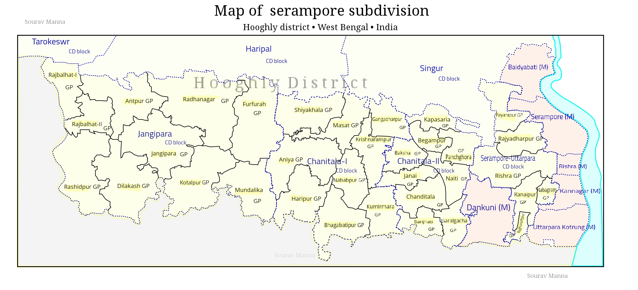
Srirampore subdivision is an administrative subdivision of the Hooghly district in the state of West Bengal, India. Overview Srirampore subdivision is the most urbanised, and the one with the highest density of population, of all the subdivisions of Hooghly district. Urbanisation started with industrialisation of the Hooghly Flats, the narrow strip of land along the Hooghly and spread inland covering a large portion of Hooghly-Damodar Plain, the agriculturally rich alluvial plains lying between the Hooghly and the Damodar. The entire area is a part of the Gangetic Delta. The Hooghly is a tidal river and has a high west bank. The spread of urbanisation obviously affected the livelihood of the people, with a high proportion of workers being engaged in non-agricultural pursuits. Subdivisions The Hooghly district is divided into the following administrative subdivisions: Administrative units 400 px, right Srirampore subdivision has 7 police stations, 4 community developme ... [...More Info...] [...Related Items...] OR: [Wikipedia] [Google] [Baidu] |


