|
Baldy Mountain (Colfax County, New Mexico)
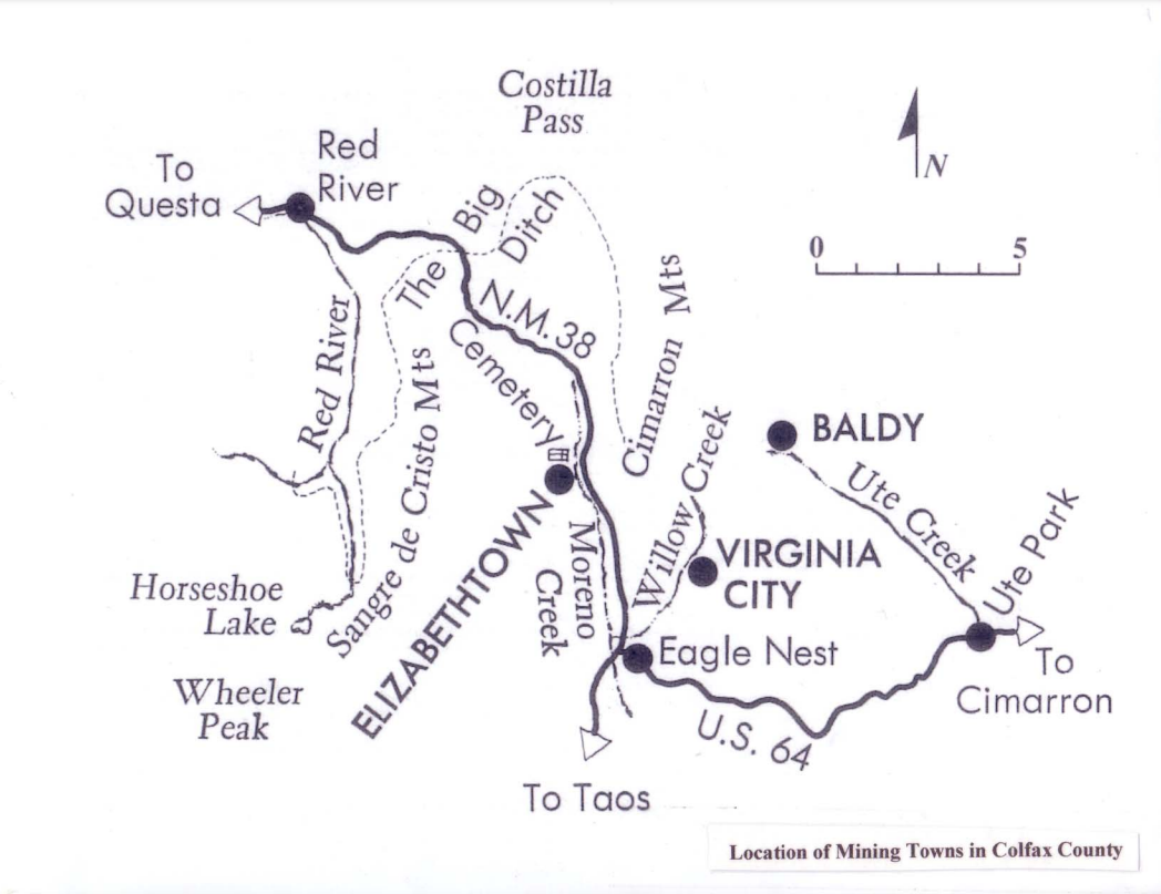
Baldy Mountain (official name), Baldy Peak, Mount Baldy, or Old Baldy is the highest peak in the Cimarron Range, a subrange of the Sangre de Cristo Mountains of New Mexico. It is located in Colfax County, about northeast of Eagle Nest. It rises abruptly, with of vertical relief (in 3 miles/4.8 km), from the Moreno Valley to the west and has a total elevation of . Philmont Scout Ranch Baldy Mountain lies on the northwestern border of the Boy Scouts of America's Philmont Scout Ranch. The valleys on the eastern side of the peak are home to some of the many small camps that are scattered throughout the Ranch. Four wheel drive roads and a radio tower exist high on the western slopes. In 1963 Norton Clapp bought around the mountain and donated it to the Boy Scouts of America. Mining Copper, gold, and silver were mined in the Baldy Mining District starting in 1866, and the top of Baldy Mountain was developed as the Mystic Lode copper mine. Other mines near Baldy Mountain wer ... [...More Info...] [...Related Items...] OR: [Wikipedia] [Google] [Baidu] |
Sangre De Cristo Mountains
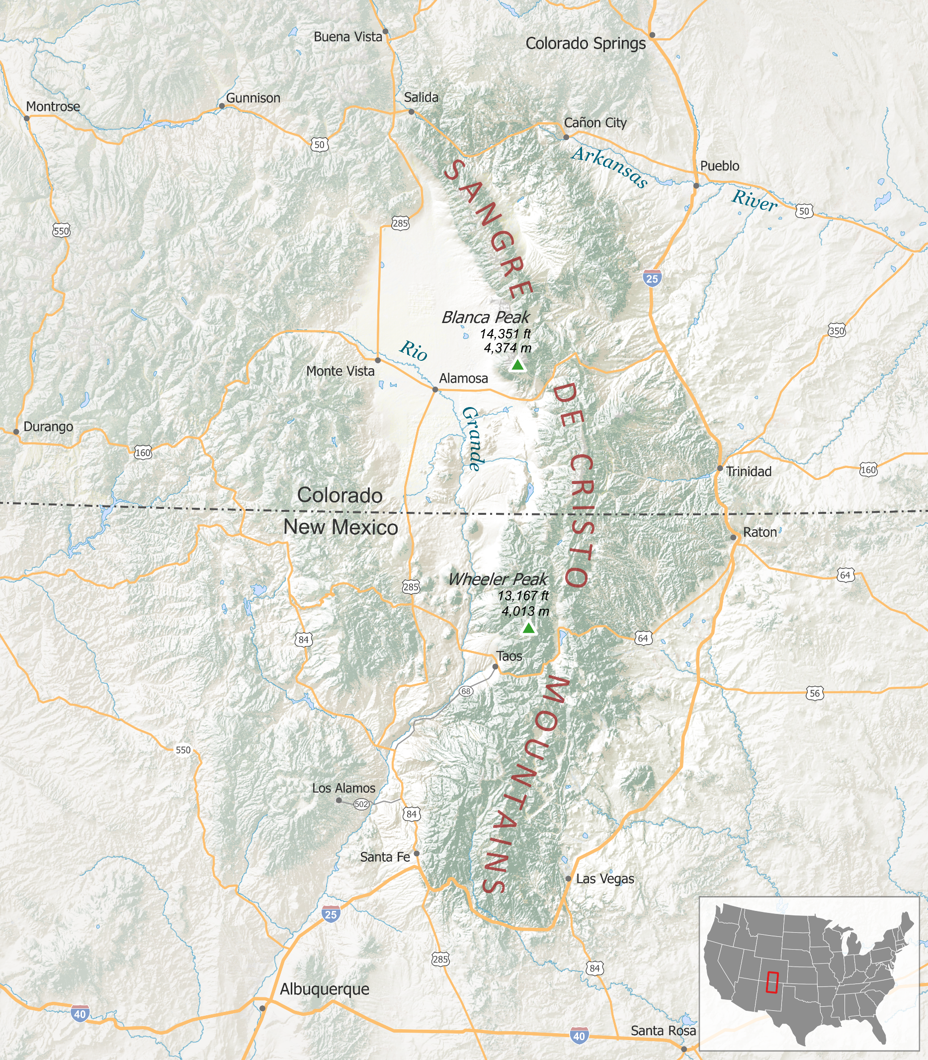
The Sangre de Cristo Mountains ( Spanish for "Blood of Christ") are the southernmost subrange of the Rocky Mountains. They are located in southern Colorado and northern New Mexico in the United States. The mountains run from Poncha Pass in South-Central Colorado, trending southeast and south, ending at Glorieta Pass, southeast of Santa Fe, New Mexico. The mountains contain a number of fourteen thousand foot peaks in the Colorado portion, as well as all the peaks in New Mexico which are over twelve thousand feet. The name of the mountains may refer to the occasional reddish hues observed during sunrise and sunset, and when alpenglow occurs, especially when the mountains are covered with snow. Although the particular origin of the name is unclear, it has been in use since the early 19th century. Before that time the terms "La Sierra Nevada", "La Sierra Madre", "La Sierra", and "The Snowies" (used by English speakers) were used.Robert Julyan, ''The Place Names of New Mexico'', Un ... [...More Info...] [...Related Items...] OR: [Wikipedia] [Google] [Baidu] |
Tooth Of Time
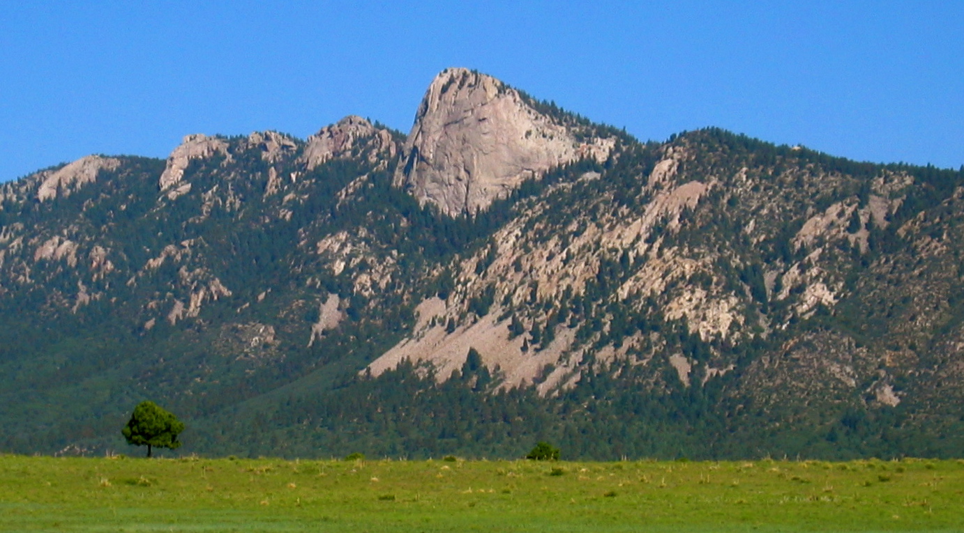
The Tooth of Time is a geological feature on the Philmont Scout Ranch located southwest of Cimarron, New Mexico, United States, and is one of Philmont's most popular sights. It is an igneous intrusion of dacite porphyry formed in the Paleogene Period of the Cenozoic Era some 22-40 million years ago. Santa Fe Trail The Tooth rises prominently from the valley floor, some below, creating a sheer vertical face unable to support substantial plant life. Both its pinkish-gray color and its unusual shape make it a particularly notable geological landmark. It was well known among the overland traders on the Santa Fe Trail, who used it to mark the final seven-day push to Santa Fe, New Mexico. Geology The Tooth was formed when magma from deep within the Earth rose through older rock layers and slowly cooled. Over many thousands of years, the older sedimentary rock eroded and left the harder igneous formation. The sedimentary rock acted as a mold for the intrusive magma, causing it to ... [...More Info...] [...Related Items...] OR: [Wikipedia] [Google] [Baidu] |
Mountains Of New Mexico
A mountain is an elevated portion of the Earth's crust, generally with steep sides that show significant exposed bedrock. Although definitions vary, a mountain may differ from a plateau in having a limited summit area, and is usually higher than a hill, typically rising at least 300 metres (1,000 feet) above the surrounding land. A few mountains are isolated summits, but most occur in mountain ranges. Mountains are formed through tectonic forces, erosion, or volcanism, which act on time scales of up to tens of millions of years. Once mountain building ceases, mountains are slowly leveled through the action of weathering, through slumping and other forms of mass wasting, as well as through erosion by rivers and glaciers. High elevations on mountains produce colder climates than at sea level at similar latitude. These colder climates strongly affect the ecosystems of mountains: different elevations have different plants and animals. Because of the less hospitable terrain and ... [...More Info...] [...Related Items...] OR: [Wikipedia] [Google] [Baidu] |
Geography And Ecology Of Philmont Scout Ranch
Philmont Scout Ranch is located in the Sangre de Cristo Mountains of the Rocky Mountains of New Mexico. Philmont is about across (east to west) at its widest point, and about long (north to south). The southern part of the ranch is mostly grasslands/prairie, while the north is rocky and rugged, but a small part of the eastern area is prairie. Geography Philmont's lowest point is the southeast corner at and the highest point is the peak of Baldy Mountain, located on the ranch's northwest boundary, at . The average rainfall at Philmont ranges from around Base Camp to in the backcountry. There are nine major watersheds at Philmont - the Rayado River, Urraca Creek, Cimarroncito Creek, Sawmill Creek, the Cimarron (La Flecha) River, Turkey Creek, Dean Canyon, the Ponil River, and Ute Creek. Geological history The Tooth of Time, as well as Baldy Mountain, Betty's Bra, Lover's Leap, Cathedral Rock, Hogback Ridge, and many of the ridges in the northwest of the ranch, is an ign ... [...More Info...] [...Related Items...] OR: [Wikipedia] [Google] [Baidu] |
4000 Meter Peaks Of The United States
The following sortable table comprises the 477 mountain peaks of the United States with at least of topographic elevation and at least of topographic prominence.This article defines a significant summit as a summit with at least of topographic prominence, and a major summit as a summit with at least of topographic prominence. All summits in this article have at least 500 meters of topographic prominence. An ultra-prominent summit is a summit with at least of topographic prominence. The summit of a mountain or hill may be measured in three principal ways: #The topographic elevation of a summit measures the height of the summit above a geodetic sea level.All elevations in the 48 states of the contiguous United States include an elevation adjustment from the National Geodetic Vertical Datum of 1929 ( NGVD 29) to the North American Vertical Datum of 1988 ( NAVD 88). For further information, please see this United States National Geodetic Surveybr>noteIf the elev ... [...More Info...] [...Related Items...] OR: [Wikipedia] [Google] [Baidu] |
Culebra Range
) , country= United States , subdivision1_type= States , subdivision1= , parent= Rocky Mountains , geology= , orogeny= , area_mi2= 17193 , range_coordinates= , length_mi= 242 , length_orientation= north-south , width_mi= 120 , width_orientation= east-west , highest= Blanca Peak , elevation_ft= 14351 , coordinates= , highest_location= East of Alamosa, Colorado , map= , map_size= , map_caption= The Sangre de Cristo Mountains (Spanish for "Blood of Christ") are the southernmost subrange of the Rocky Mountains. They are located in southern Colorado and northern New Mexico in the United States. The mountains run from Poncha Pass in South-Central Colorado, trending southeast and south, ending at Glorieta Pass, southeast of Santa Fe, New Mexico. The mountains contain a number of fourteen thousand foot peaks in the Colorado portion, as well as all the peaks in New Mexico which are over twelve thousand feet. The name of the mountains may refer to the occasiona ... [...More Info...] [...Related Items...] OR: [Wikipedia] [Google] [Baidu] |
List Of Peaks Named Baldy
There are a number of peaks named Baldy: Canada * Baldy Mountain (Manitoba), , * Big Baldy Mountain (Vancouver Island, British Columbia), United States Peaks named "Baldy" Peaks named "Baldy Mountain" Peaks named "Baldy Peak" Peaks named "Big Baldy" or "Little Baldy" Peaks named "Mount Baldy" Peaks named "Old Baldy" Peaks with other variants of "Baldy" {{mountainindex, Baldy ... [...More Info...] [...Related Items...] OR: [Wikipedia] [Google] [Baidu] |
Mount Phillips (New Mexico)
Mount Phillips, formerly called Clear Creek Mountain was renamed in 1960 in honor of the then living Waite Phillips, who donated the area to the Boy Scouts of America. It is located in Colfax County, New Mexico, Colfax County about south of Baldy Mountain (Colfax County, New Mexico), Baldy Mountain in the Sangre de Cristo Mountains#Cimarron Range, Cimarron Range, a subrange of the Sangre de Cristo Mountains of New Mexico. Philmont Scout Ranch Mount Phillips is the second highest peak in Boy Scouts of America's Philmont Scout Ranch in the central country on the western perimeter. It is an easy hike from Comanche Peak, but it is a much steeper ascent from Clear Creek to its summit. There are four close trail camps in the area of the summit, but none have water. These are Mount Phillips, Comanche Peak, Thunder Ridge and Red Hills Camps, which, except for Red Hills Camp, are all dry. The staff camp of Clear Creek is the closest camp with water. Geology The mountain consists ... [...More Info...] [...Related Items...] OR: [Wikipedia] [Google] [Baidu] |
French Henry Mine
The French Henry mine is a gold and silver mine located on Baldy Mountain (Colfax County, New Mexico). The mine was in operation intermittently from 1870 to 1938. Part of the Baldy Mining District, the mine has changed ownership many times and is now owned by the Boy Scouts of America as a part of Philmont Scout Ranch. The French Henry is no longer operational. History The French Henry mine was originally discovered in 1869 by a team led by Henry Buruel; the mine's namesake. The deed to the mine was obtained from Lucian Maxwell and mining operations started in 1870. Operations were halted later that same year due to a lack of ability to process the ore. Maxwell's nearby Aztec Mill would not process the ore from the French Henry. Shipping the ore elsewhere to be processed would have been prohibitively expensive. In 1894, mining started again, this time under the Claude Mining and Milling company. The new owners installed a 15 stamp stamp mill along the South Ponil River with a ... [...More Info...] [...Related Items...] OR: [Wikipedia] [Google] [Baidu] |
Colfax County, New Mexico
Colfax County is a county in the U.S. state of New Mexico. As of the 2010 census, the population was 13,750. Its county seat is Raton. It is south from the Colorado state line. This county was named for Schuyler Colfax (18231885), seventeenth Vice President of the United States under U.S. President Ulysses S. Grant. Colfax County is the home of Philmont Scout Ranch and the NRA Whittington Center. History Colfax County was originally part of Taos County, one of the original nine counties created by the New Mexico Territory in 1852. In 1859, the eastern part of Taos County, including all of the territory of Colfax County, was split off to form Mora County. Colfax County was established on January 25, 1869, from the northern part of Mora County. The original county seat was the gold mining town of Elizabethtown. By 1872, when the gold rush in Elizabethtown had died down, the county seat was moved to Cimarron. Cimarron was on the stage coach route along the Mountain Br ... [...More Info...] [...Related Items...] OR: [Wikipedia] [Google] [Baidu] |
Baldy Mining District
The Baldy Mining District was one of the largest gold producing districts in New Mexico. Also sometimes known as the Elizabethtown Mining District, it encompasses Baldy Mountain (Colfax County, New Mexico).McLemore, V.T., 2017, Mining districts and prospect areas of New Mexico: New Mexico Bureau of Geology and Mineral Resources, Resource Map 24, 65 p., scale 1:1,000,000. There is no longer any large scale mining. Most of the land is now owned by the Boy Scouts of America as a part of Philmont Scout Ranch. The Baldy Mining District is approximately 18,247 Acres. History Gold was originally found on Baldy Mountain in 1866. Early in the year of 1866, Native Americans (either from the Ute or Jicarilla Apache tribes) found a large deposit of copper bearing ores. They traded these ores with soldiers at Fort Union. With the Civil war over, the soldiers decided that they could mine the copper for profit. One of the Native Americans showed a soldier where they had found the copper, on ... [...More Info...] [...Related Items...] OR: [Wikipedia] [Google] [Baidu] |
Norton Clapp
Matthew Norton Clapp (April 15, 1906 – April 22, 1995) was a successful businessman, and eventually served as chairman of the Weyerhaeuser Corporation. He was active in civic service and a philanthropist. Early life and career Clapp was born in Pasadena, California. He was named for his maternal grandfather Matthew G. Norton, a Winona, Minnesota lumberman who via the Laird, Norton Company was to help finance the Weyerhaeuser purchase of land in Washington State in 1900. Clapp received an A.B. from Occidental College and a Ph.B in 1928 from the University of Chicago and a J.D. from Chicago in 1929. He practiced law in Tacoma, Washington from 1929 until 1942. He was among the developers of Lakewood Colonial Center in 1937 in what is now Lakewood, WA. It was one of the first shopping centers west of the Mississippi River. In 1938, he converted an existing structure into the Lakewood Ice Arena. He became a trustee of the University of Puget Sound in 1933 and would serve ... [...More Info...] [...Related Items...] OR: [Wikipedia] [Google] [Baidu] |


