|
Bahirawakanda
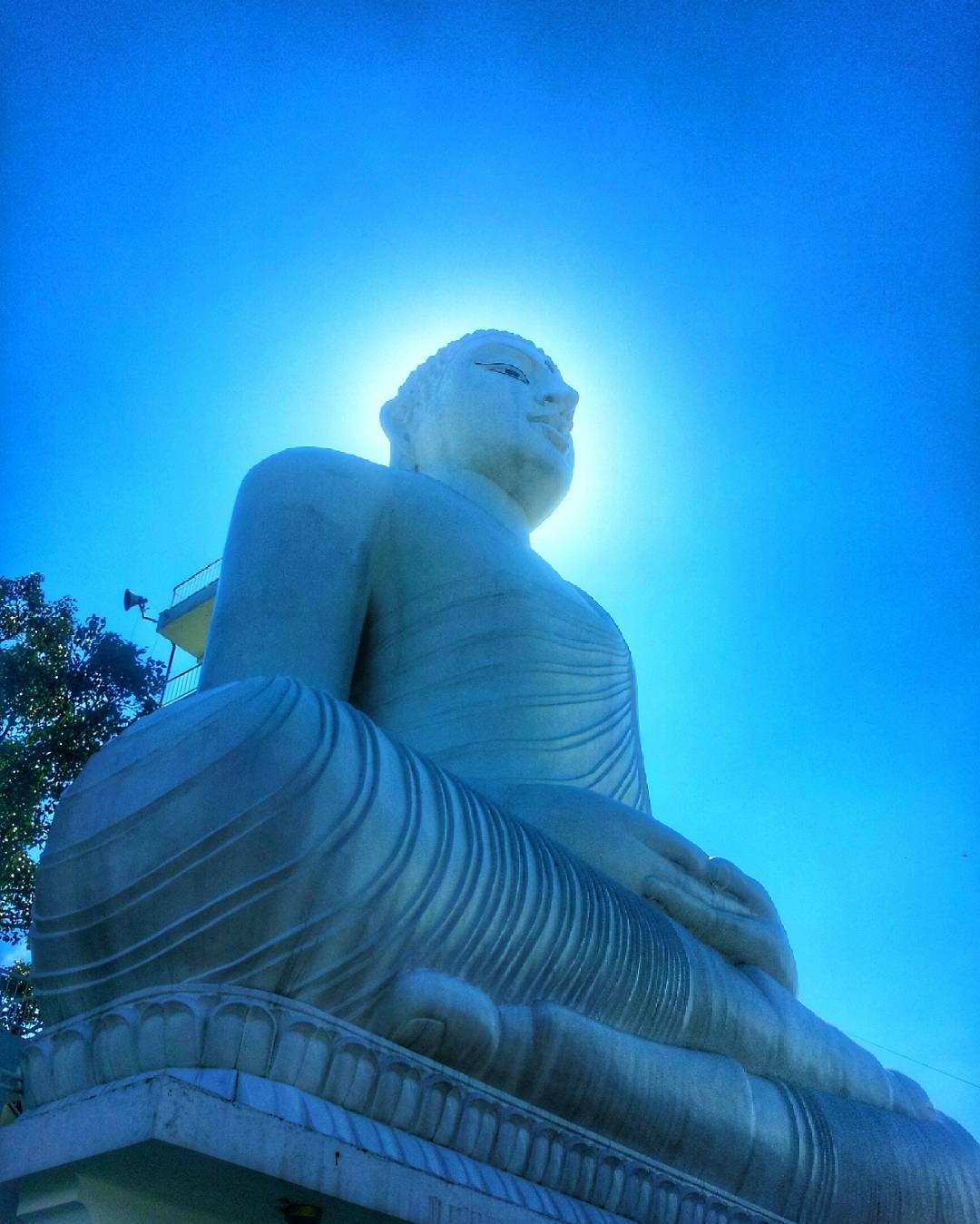
Bahirawakanda ( si, බහිරවකන්ද) is a village in the centre of the Kandy, Sri Lanka. In Sinhala, ''Bahirawa Kanda'' translates to mountain of Bahirawa. According to Sri Lankan myths, Bahirawa is a sanguinary deity associated with earth and territory protection. It is known for the Sri Maha Bodhi Viharaya, construction of which commenced in 1972, under the direction of Ven. Ampitiye Dammarama Thero. It was opened to the public on 1 January 1993, by President Ranasinghe Premadasa. See also *List of towns in Central Province, Sri Lanka Central Province is a province of Sri Lanka, containing the Kandy District, Matale District, and Nuwara Eliya District. The following is a list of settlements in the province. __NOTOC__ A Abasingammedda, Adhikarigama, Agalakumbura, Agalawa ... References External links * Populated places in Kandy District {{KandyDistrict-geo-stub ... [...More Info...] [...Related Items...] OR: [Wikipedia] [Google] [Baidu] |
Sri Maha Bodhi Viharaya
Sri Maha Bodhi Viharaya is a Theravada Buddhist temple in Kandy, Sri Lanka. It is located in Bahirawakanda, approximately from the city centre. The temple is known for its giant Buddha statue. The statue of Buddha is depicted in the position of the ''Dhyana Mudra,'' the posture of meditation associated with his first Enlightenment, and can be seen from almost everywhere in Kandy. It stands at high and is one of the tallest Buddha statues in Sri Lanka. The temple is built on land donated by the Ministry of Lands and Parliamentary Reforms#Ministers, Minister of Lands, Hector Kobbekaduwa, to Ven. Ampitiye Dammarama Thero, a monk from the Amarapura Nikaya in the early 1970s. Initially Dammarama lived in a makeshift dwelling whilst soliciting funds for the construction of the temple. The temple was opposed by the senior monks of the Temple of the Tooth, Sri Dalada Maligawa (Temple of the Sacred Tooth Relic), claiming it would overshadow the centre of the Siyam Nikaya. In the 1980s ... [...More Info...] [...Related Items...] OR: [Wikipedia] [Google] [Baidu] |
Kandy
Kandy ( si, මහනුවර ''Mahanuwara'', ; ta, கண்டி Kandy, ) is a major city in Sri Lanka located in the Central Province. It was the last capital of the ancient kings' era of Sri Lanka. The city lies in the midst of hills in the Kandy plateau, which crosses an area of tropical plantations, mainly tea. Kandy is both an administrative and religious city and is also the capital of the Central Province. Kandy is the home of the Temple of the Tooth Relic ('' Sri Dalada Maligawa''), one of the most sacred places of worship in the Buddhist world. It was declared a world heritage site by UNESCO in 1988. Historically the local Buddhist rulers resisted Portuguese, Dutch, and British colonial expansion and occupation. Etymology The city and the region have been known by many different names and versions of those names. Some scholars suggest that the original name of Kandy was Katubulu Nuwara located near the present Watapuluwa. However, the more popular historical ... [...More Info...] [...Related Items...] OR: [Wikipedia] [Google] [Baidu] |
List Of Towns In Central Province, Sri Lanka
Central Province is a province of Sri Lanka, containing the Kandy District, Matale District, and Nuwara Eliya District. The following is a list of settlements in the province. __NOTOC__ A Abasingammedda, Adhikarigama, Agalakumbura, Agalawatta, Agappola, Agrapatana, Agrapatna, Akarahaduwa, Akkarawatta, Akuramboda, Akurambodwatta, Akurana, Aladeniya, Alagalla Kondagama, Alagalla Pahalagama, Alagoda, Alakagama, Alakola-anga, Alakola-ela, Alakoladeniya, Alakolamada, Alakolamaditta, Alakolawewa, Alanduwaka, Alapalawala, Alapalawela, Alawattegama, Alawattegama, Alawatugama, Alawatugoda, Alayaya, Alhentennawatta, Alkemada, Alubendiyaya, Aludeniya, Alugolla (7°5'N 80°28'E), Alugolla (7°9'N 80°31'E), Alugolla (7°40'N 80°37'E), Alupotawela, Alutgama (7°19'N 80°31'E), Alutgama (7°31'N 80°35'E), Alutgama (7°42'N 80°35'E), Alutgama (7°22'N 80°39'E), Alutgama Mahakumburegammedda, Alutnuwara, Alutnuwara Town, Alutwatta Alutwewa, Aluvih ... [...More Info...] [...Related Items...] OR: [Wikipedia] [Google] [Baidu] |
Provinces Of Sri Lanka
In Sri Lanka, provinces ( si, පළාත, translit=Paḷāta; ta, மாகாணம், translit=Mākāṇam) are the first level administrative division. They were first established by the British rulers of Ceylon in 1833. Over the next century most of the administrative functions were transferred to the districts, the second level administrative division. By the middle of the 20th century the provinces had become merely ceremonial. This changed in 1987 when, following several decades of increasing demand for a decentralization, the 13th Amendment to the 1978 Constitution of Sri Lanka established provincial councils. Currently there are nine provinces. History Anuradhapura Kingdom Administrative areas of the Kingdom of Anuradhapura. Rajarata was the personal domain of the King. It was further divided in to four districts (Desa): Dakkina, Pachhima, Uttara and Pacina Desa. British Ceylon After the British took control of the entire island of Ceylon in 1815 it was divi ... [...More Info...] [...Related Items...] OR: [Wikipedia] [Google] [Baidu] |
Districts Of Sri Lanka
In Sri Lanka, districts ( si, දිස්ත්රික්ක, ''Distrikka'', ta, மாவட்டம், ''Māvaṭṭam'') are the second-level administrative divisions, and are included in a province. There are 25 districts organized into 9 provinces. Each district is administered under a district secretary, who is appointed by the central government. The main tasks of the district secretariat involve coordinating communications and activities of the central government and divisional secretariats. The district secretariat is also responsible for implementing and monitoring development projects at the district level and assisting lower-level subdivisions in their activities, as well as revenue collection and coordination of elections in the district. A district is divided into a number of Divisional Secretary's Divisions (commonly known as DS divisions), which are in turn subdivided into 14,022 grama niladhari divisions. There are 331 DS divisions in the country ... [...More Info...] [...Related Items...] OR: [Wikipedia] [Google] [Baidu] |

