|
Bahadur Khel
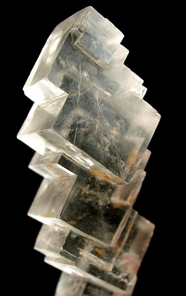
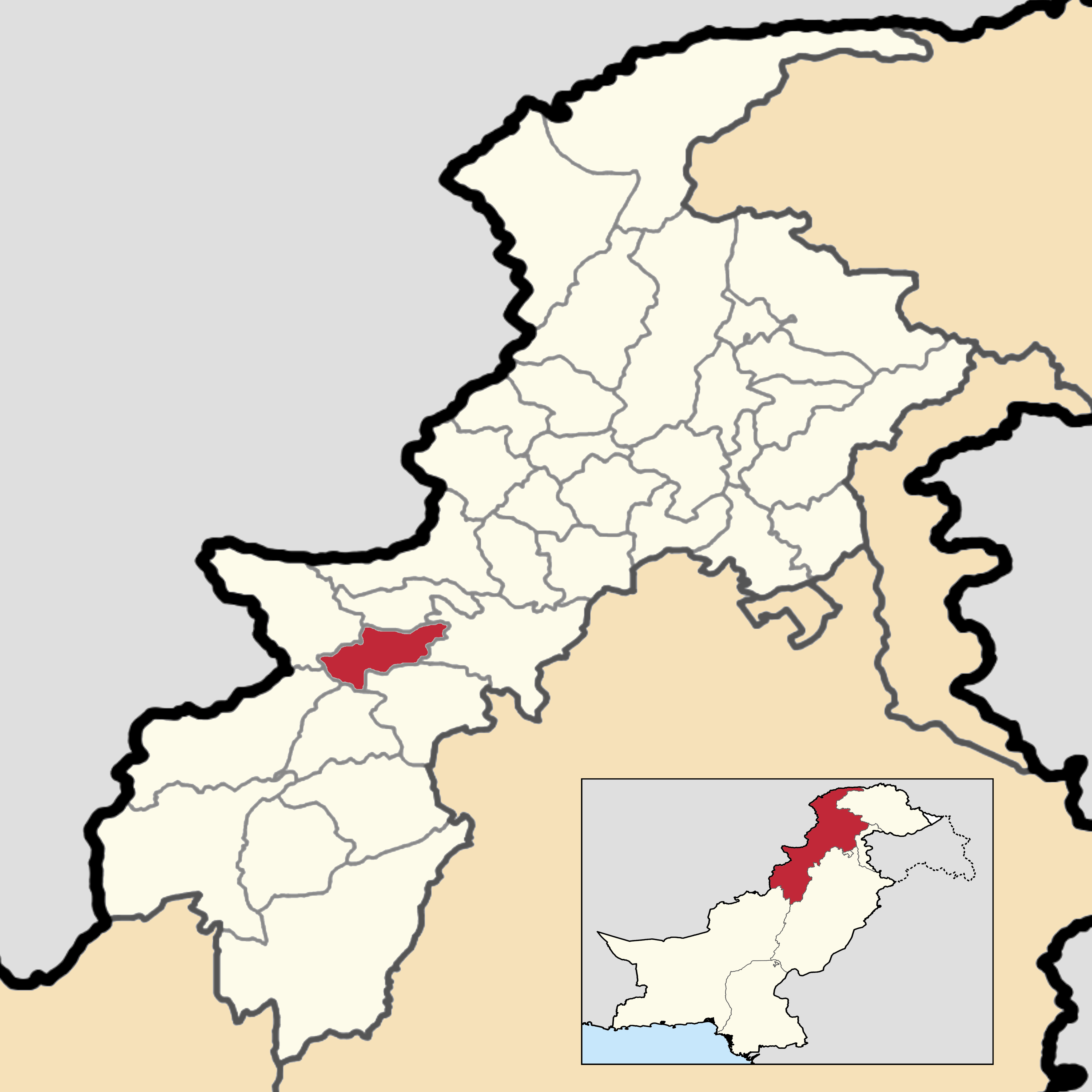
Bahadur Khel is a village and Union Council of Karak District in Khyber Pakhtunkhwa province of Pakistan. It is located at 33°10'57N 70°57'15E with an altitude of 548 metres (1801 feet). The village is the site of an extensive rock salt quarry. The quarry (one mile long by half a mile broad) produces high-quality rock salt suitable for human consumption. The facility is managed by the Pakistan Mineral Development Corporation. Bahadurkhel Para. Para is a tradition which dates back to earlier inhabitation of the village by the founders, who were all khattaks. Para is primarily a visit or expedition towards the mountains of Manzalai, Tareeqa,and Wanjorae Garhy, which are rich sites for harvesting the local fruit called ''gurguray'' (which appears similar to blueberries but is different). The villagers take their food and camping supplies to the mountains, where musical skills, traditional songs and dance are shown in the wild. In total they spend three days in the mountains, and o ... [...More Info...] [...Related Items...] OR: [Wikipedia] [Google] [Baidu] |
Union Councils Of Pakistan
The union councils of Pakistan ( ur, ), referred to as village councils in villages, are an elected local government body consisting of 21 councillors, and headed by a Nazim which is equivalent to a mayor or chairperson and a Naib Nazib (vice chairperson). As of 2007, there are 5,375 rural union councils across 115 districts. They form the third-tier of local government and fifth tier overall. Its structure and responsibilities differ between provinces and territories. Administration Union councils are the primary governmental institution in Pakistan, Union Councils are often known as "Village Councils" in rural areas,the territory represented by a Village Council usually comprises a large village and surrounding areas, often including nearby small villages. The term Union Council may be used for localities that are part of cities. The territory of a Union Council or Village Council is usually part of a Tehsil (county). Less commonly, a Union Council may be part of a City Distr ... [...More Info...] [...Related Items...] OR: [Wikipedia] [Google] [Baidu] |
Karak District
Karak District ( ps, کرک ولسوالۍ, ur, ) is a district in Kohat Division of Khyber Pakhtunkhwa province in Pakistan. It is situated to the south of Kohat District and on the north side of Bannu and Lakki Marwat districts on the main Indus Highway between Peshawar and Karachi – it is 123 km from the provincial capital Peshawar. It gained a district status in 1982, prior to which it was part of Kohat District. It is natively inhabited by the Khattak Pashtun tribe who make the majority of the population. Demographics At the time of the 2017 census the district had a population of 705,362, of which 348,315 were males and 357,004 females. Rural population was 654,276 (92.76%) while the urban population was 51,086 (7.24%). The literacy rate was 63.75% - the male literacy rate was 84.37% while the female literacy rate was 44.41%. 285 people in the district were from religious minorities. Pashto was the predominant language, spoken by 99.16% of the population. Resour ... [...More Info...] [...Related Items...] OR: [Wikipedia] [Google] [Baidu] |
Khyber Pakhtunkhwa
Khyber Pakhtunkhwa (; ps, خېبر پښتونخوا; Urdu, Hindko: خیبر پختونخوا) commonly abbreviated as KP or KPK, is one of the Administrative units of Pakistan, four provinces of Pakistan. Located in the Geography of Pakistan, northwestern region of the country, Khyber Pakhtunkhwa is the smallest province of Pakistan by land area and the Demographics of Pakistan, third-largest province by population after Punjab, Pakistan, Punjab and Sindh. It shares land borders with the Pakistani provinces of Balochistan, Pakistan, Balochistan to the south, Punjab, Pakistan, Punjab to the south-east and province of Gilgit-Baltistan to the north and north-east, as well as Islamabad Capital Territory to the east, Azad Jammu and Kashmir, Autonomous Territory of Azad Jammu and Kashmir to the north-east. It shares an Durand Line, international border with Afghanistan to the west. Khyber Pakhtunkhwa is known as a tourist hot spot for adventurers and explorers and has a varied landsca ... [...More Info...] [...Related Items...] OR: [Wikipedia] [Google] [Baidu] |
Pakistan
Pakistan ( ur, ), officially the Islamic Republic of Pakistan ( ur, , label=none), is a country in South Asia. It is the world's List of countries and dependencies by population, fifth-most populous country, with a population of almost 243 million people, and has the world's Islam by country#Countries, second-largest Muslim population just behind Indonesia. Pakistan is the List of countries and dependencies by area, 33rd-largest country in the world by area and 2nd largest in South Asia, spanning . It has a coastline along the Arabian Sea and Gulf of Oman in the south, and is bordered by India to India–Pakistan border, the east, Afghanistan to Durand Line, the west, Iran to Iran–Pakistan border, the southwest, and China to China–Pakistan border, the northeast. It is separated narrowly from Tajikistan by Afghanistan's Wakhan Corridor in the north, and also shares a maritime border with Oman. Islamabad is the nation's capital, while Karachi is its largest city and fina ... [...More Info...] [...Related Items...] OR: [Wikipedia] [Google] [Baidu] |
Halite
Halite (), commonly known as rock salt, is a type of salt, the mineral (natural) form of sodium chloride ( Na Cl). Halite forms isometric crystals. The mineral is typically colorless or white, but may also be light blue, dark blue, purple, pink, red, orange, yellow or gray depending on inclusion of other materials, impurities, and structural or isotopic abnormalities in the crystals. It commonly occurs with other evaporite deposit minerals such as several of the sulfates, halides, and borates. The name ''halite'' is derived from the Ancient Greek word for "salt", ἅλς (''háls''). Occurrence Halite dominantly occurs within sedimentary rocks where it has formed from the evaporation of seawater or salty lake water. Vast beds of sedimentary evaporite minerals, including halite, can result from the drying up of enclosed lakes and restricted seas. Such salt beds may be hundreds of meters thick and underlie broad areas. Halite occurs at the surface today in playas in regio ... [...More Info...] [...Related Items...] OR: [Wikipedia] [Google] [Baidu] |
Pakistan Mineral Development Corporation
The Pakistan Mineral Development Corporation (PMDC) ( ur, ) is a semi-autonomous corporation attached to the ''Ministry of Petroleum and Natural Resources'', of the Government of Pakistan. It was created in 1973 with an authorized capital of Rs.1,000 million (approximately 10 million U.S. dollars) to expand and help mineral development activities in the country.Govt takes stringent measures for uplift of minerals sector The Nation (Pakistani newspaper), Published 13 October 2021, Retrieved 15 November 2021 PMDC headquarters are in . The company operates salt mine/quarries, coal mines and a silica sand quarry. This compa ... [...More Info...] [...Related Items...] OR: [Wikipedia] [Google] [Baidu] |
British Raj
The British Raj (; from Hindi ''rāj'': kingdom, realm, state, or empire) was the rule of the British Crown on the Indian subcontinent; * * it is also called Crown rule in India, * * * * or Direct rule in India, * Quote: "Mill, who was himself employed by the British East India company from the age of seventeen until the British government assumed direct rule over India in 1858." * * and lasted from 1858 to 1947. * * The region under British control was commonly called India in contemporaneous usage and included areas directly administered by the United Kingdom, which were collectively called British India, and areas ruled by indigenous rulers, but under British paramountcy, called the princely states. The region was sometimes called the Indian Empire, though not officially. As ''India'', it was a founding member of the League of Nations, a participating nation in the Summer Olympics in 1900, 1920, 1928, 1932, and 1936, and a founding member of the United Nations in San F ... [...More Info...] [...Related Items...] OR: [Wikipedia] [Google] [Baidu] |
Kohat Division
Kohat Division is one of seven divisions in Pakistan's Khyber Pakhtunkhwa province. It consists of five districts: Hangu, Karak, Kohat, Kurram, and Orakzai. According to the 2017 Pakistani Census, the division had a population of 3,211,458, making it the third-least populous division in the province, and it spans of area, and this makes it the fourth-largest division by area in the province. Kohat is the division's largest city and namesake, with over 220,000 inhabitants. The division borders Bannu Division to the south and west, Peshawar Division to the north and east, the province of Punjab, Pakistan to its east, and the country of Afghanistan to its northwest. Districts Districts are the administrative unit one level below divisions in the administrative hierarchy of Pakistan. Kohat Division consists of the following five districts: History In 1941, the area which today covers the division (excluding Orakzai and Kurram) was known as Kohat District. Kohat Distr ... [...More Info...] [...Related Items...] OR: [Wikipedia] [Google] [Baidu] |
British India
The provinces of India, earlier presidencies of British India and still earlier, presidency towns, were the administrative divisions of British governance on the Indian subcontinent. Collectively, they have been called British India. In one form or another, they existed between 1612 and 1947, conventionally divided into three historical periods: *Between 1612 and 1757 the East India Company set up Factory (trading post), factories (trading posts) in several locations, mostly in coastal India, with the consent of the Mughal emperors, Maratha Empire or local rulers. Its rivals were the merchant trading companies of Portugal, Denmark, the Netherlands, and France. By the mid-18th century, three ''presidency towns'': Madras, Bombay and Calcutta, had grown in size. *During the period of Company rule in India (1757–1858), the company gradually acquired sovereignty over large parts of India, now called "presidencies". However, it also increasingly came under British government over ... [...More Info...] [...Related Items...] OR: [Wikipedia] [Google] [Baidu] |
Bahader Khel
Bahadur Khel is a village and Union Council of Karak District in Khyber Pakhtunkhwa province of Pakistan. It is located at 33°10'57N 70°57'15E with an altitude of 548 metres (1801 feet). The village is the site of an extensive rock salt quarry. The quarry (one mile long by half a mile broad) produces high-quality rock salt suitable for human consumption. The facility is managed by the Pakistan Mineral Development Corporation. Bahadurkhel Para. Para is a tradition which dates back to earlier inhabitation of the village by the founders, who were all khattaks. Para is primarily a visit or expedition towards the mountains of Manzalai, Tareeqa,and Wanjorae Garhy, which are rich sites for harvesting the local fruit called ''gurguray'' (which appears similar to blueberries but is different). The villagers take their food and camping supplies to the mountains, where musical skills, traditional songs and dance are shown in the wild. In total they spend three days in the mountains, and o ... [...More Info...] [...Related Items...] OR: [Wikipedia] [Google] [Baidu] |
Populated Places In Karak District
Population typically refers to the number of people in a single area, whether it be a city or town, region, country, continent, or the world. Governments typically quantify the size of the resident population within their jurisdiction using a census, a process of collecting, analysing, compiling, and publishing data regarding a population. Perspectives of various disciplines Social sciences In sociology and population geography, population refers to a group of human beings with some predefined criterion in common, such as location, race, ethnicity, nationality, or religion. Demography is a social science which entails the statistical study of populations. Ecology In ecology, a population is a group of organisms of the same species who inhabit the same particular geographical area and are capable of interbreeding. The area of a sexual population is the area where inter-breeding is possible between any pair within the area and more probable than cross-breeding with ind ... [...More Info...] [...Related Items...] OR: [Wikipedia] [Google] [Baidu] |


