|
BR-308
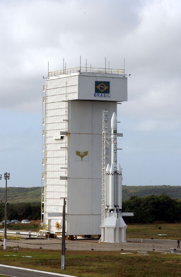
BR-308 is a federal highway that connects the cities of Belém, Pará, and the locality of ''Atracadouro do Cojupe'' in the municipality of Alcântara in Maranhão. It is also designated as part of the Belém–Brasília Highway, in its stretch between Belém and Santa Maria do Pará. Near Alcântara, there is a space center from which satellite launch vehicles are launched, the CLA - Alcântara Space Center. In Latin America, CLA is the only competitor for the Kourou Space Center in French Guiana. UNIAN
The UNIAN or Ukrainian Independent Information Agency of News ( uk, Українське Незалежне Інформаційне ...
[...More Info...] [...Related Items...] OR: [Wikipedia] [Google] [Baidu] |
Belém–Brasília Highway
The Belém–Brasília Highway (in Portuguese: ''Rodovia Belém–Brasília'') is a set of portions of six federal highways of Brazil, of which each portion contributes to the function of connecting the Atlantic port city of Belém in the northern state of Pará and the Brazilian Federal District Brasília in the southern interior. The Belém–Brasília Highway designation applies (between Belém and each respective city) to the following routes: * BR-316 ( Santa Maria do Pará), * BR-308 (Santa Maria do Pará), and * BR-010 ( Estreito). It also applies to * BR-226 between Porto Franco and Wanderlândia, * BR-153 thence to and from Anápolis, and * BR-060 thence to and from Brasília. In each case, the route in question extends beyond one or both of the cities that demarcate the respective stretch of the Belém–Brasília Highway, while the stretch(es) beyond lack that designation. History The Belém–Brasília Highway was the first road built through the central and the mi ... [...More Info...] [...Related Items...] OR: [Wikipedia] [Google] [Baidu] |
Alcântara, Maranhão
Alcântara is a Brazilian municipality in the state of Maranhão. The city has a population of 22,112 (2020) and an area of 1458 km2. The municipality is 30 km away from the state's capital, São Luís. Founded by French explorers in the 16th century, Alcântara was later conquered by the Portuguese, who used the small village as a base to take São Luís from the Dutch in 1646. The city was declared by the Brazilian government as a National Historical Patrimony. The city's economy is based mainly on tourism and fishing. The climate is favorable, characterized by two well-defined seasons: a rainy season from January to June, and a dry season from July to December. The annual average temperature is 26.5 °C, and the wind blows predominantly from the east at an average speed of 12 m/s. Helton da Silva Arruda, a famous Brazilian goalkeeper, was born in the city. The municipality contains a small part of the Baixada Maranhense Environmental Protection Area, a ... [...More Info...] [...Related Items...] OR: [Wikipedia] [Google] [Baidu] |
Maranhão
Maranhão () is a state in Brazil. Located in the country's Northeast Region, it has a population of about 7 million and an area of . Clockwise from north, it borders on the Atlantic Ocean for 2,243 km and the states of Piauí, Tocantins and Pará. The people of Maranhão have a distinctive accent inside the common Northeastern Brazilian dialect. Maranhão is described in books such as '' The Land of the Palm Trees'' by Gonçalves Dias and ''Casa de Pensão'' by Aluísio Azevedo. The dunes of Lençóis are an important area of environmental preservation. Also of interest is the state capital of São Luís, designated a Unesco World Heritage Site. Another important conservation area is the Parnaíba River delta, between the states of Maranhão and Piauí, with its lagoons, desert dunes and deserted beaches or islands, such as the Caju island, which shelters rare birds. Geography The northern portion of the state is a heavily forested plain traversed by numerous rive ... [...More Info...] [...Related Items...] OR: [Wikipedia] [Google] [Baidu] |
Belém
Belém (; Portuguese for Bethlehem; initially called Nossa Senhora de Belém do Grão-Pará, in English Our Lady of Bethlehem of Great Pará) often called Belém of Pará, is a Brazilian city, capital and largest city of the state of Pará in the country's north. It is the gateway to the Amazon River with a busy port, airport, and bus/coach station. Belém lies approximately 100 km upriver from the Atlantic Ocean, on the Pará River, which is part of the greater Amazon River system, separated from the larger part of the Amazon delta by ''Ilha de Marajó'' ( Marajo Island). With an estimated population of 1,499,641 people — or 2,491,052, considering its metropolitan area — it is the 11th most populous city in Brazil, as well as the 16th by economic relevance. It is the second largest in the North Region, second only to Manaus, in the state of Amazonas. Founded in 1616 by the Kingdom of Portugal, Belém was the first European colony on the Amazon but did not beco ... [...More Info...] [...Related Items...] OR: [Wikipedia] [Google] [Baidu] |
Pará
Pará is a state of Brazil, located in northern Brazil and traversed by the lower Amazon River. It borders the Brazilian states of Amapá, Maranhão, Tocantins, Mato Grosso, Amazonas and Roraima. To the northwest are the borders of Guyana and Suriname, to the northeast of Pará is the Atlantic Ocean. The capital and largest city is Belém, which is located at the mouth of the Amazon. The state, which is home to 4.1% of the Brazilian population, is responsible for just 2.2% of the Brazilian GDP. Pará is the most populous state of the North Region, with a population of over 8.6 million, being the ninth-most populous state in Brazil. It is the second-largest state of Brazil in area, at , second only to Amazonas upriver. Its most famous icons are the Amazon River and the Amazon Rainforest. Pará produces rubber (extracted from natural rubber tree groves), cassava, açaí, pineapple, cocoa, black pepper, coconut, banana, tropical hardwoods such as mahogany, and mine ... [...More Info...] [...Related Items...] OR: [Wikipedia] [Google] [Baidu] |
Brazilian Highway System
The Brazilian Highway System ( Portuguese: ''Sistema Nacional de Rodovias'') is a network of trunk roads administrated by the Ministry of Infrastructure of Brazil (MINFRA). It is constructed, managed and maintained by the National Department of Transport Infrastructure (DNIT), federal agency linked to the Ministry of Infrastructure, and the public works departments of state governments. The National Travel System ( Portuguese: ''Sistema Nacional de Viação –'' SNV) comprises the road infrastructure and the operational structure of the different means of transporting people and goods. As for jurisdiction, the national road system is composed of the Federal Road Traffic System ( Portuguese: Sistema Federal de Viação – SFV) and the road systems of the States, the Federal District and the Municipalities. The Investment Partnership Program (PPI) is a major effort to expand and upgrade the network of highways aside with the Federal Highway Concessions Program (PROCROFE). The ... [...More Info...] [...Related Items...] OR: [Wikipedia] [Google] [Baidu] |
Municipalities Of Brazil
The municipalities of Brazil ( pt, municípios do Brasil) are administrative divisions of the Brazilian states. Brazil currently has 5,570 municipalities, which, given the 2019 population estimate of 210,147,125, makes an average municipality population of 37,728 inhabitants. The average state in Brazil has 214 municipalities. Roraima is the least subdivided state, with 15 municipalities, while Minas Gerais is the most subdivided state, with 853. The Federal District cannot be divided into municipalities, which is why its territory is composed of several administrative regions. These regions are directly managed by the government of the Federal District, which exercises constitutional and legal powers that are equivalent to those of the states, as well as those of the municipalities, thus simultaneously assuming all the obligations arising from them. The 1988 Brazilian Constitution treats the municipalities as parts of the Federation and not simply dependent subdivision ... [...More Info...] [...Related Items...] OR: [Wikipedia] [Google] [Baidu] |
Santa Maria Do Pará
Santa Maria do Pará is a municipality in the state of Pará in the Northern region of Brazil. See also *List of municipalities in Pará This is a list of the municipalities in the state of Pará (PA), located in the North Region of Brazil. Pará is divided into 144 municipalities, which are grouped into 22 microregions, which are grouped into 6 mesoregions. [...More Info...] [...Related Items...] OR: [Wikipedia] [Google] [Baidu] |
Alcântara Space Center
The Alcântara Space Center ( pt, Centro Espacial de Alcântara, CEA), former known as ''Alcântara Launch Center'' ( pt, Centro de Lançamento de Alcântara,) is a space center and launching facility of the Brazilian Space Agency in the city of Alcântara, located on Brazil's northern Atlantic coast, in the state of Maranhão.Brazil, Ukraine to launch rocket together in 2010 (December 3, 2009) It is operated by the (). The CEA is the closest launching base to the |
UNIAN
The UNIAN or Ukrainian Independent Information Agency of News ( uk, Українське Незалежне Інформаційне Агентство Новин, УНІАН, translit=Ukrayins'ke Nezalezhne Informatsiyne Ahentstvo Novyn) is a Kyiv-based Ukrainian news agency. It produces and provides political, business and financial information, and a photo reporting service. UNIAN is a part of 1+1 Media Group, related to oligarch Ihor Kolomoyskyi. UNIAN was founded in March 1993 as the Ukrainian Independent Information Agency of News. The agency's offices are at 4 Khreshchatyk Street, adjacent to European Square, in Kyiv. UNIAN offers its press conference hall to interested customers. UNIAN runs a TV channel, UNIAN TV, broadcasting news, analytical programs, documentaries, sport and movies. It is available on satellite, cable and IPTV networks. It broadcasts unencrypted from the AMOS-2 satellite (4.0 W), at 10722 Horizonal, 27500. The channel's General Producer is Vlad ... [...More Info...] [...Related Items...] OR: [Wikipedia] [Google] [Baidu] |

.jpg)


